Maryland Analyzes Coastal Wetlands Susceptibility to Climate Change
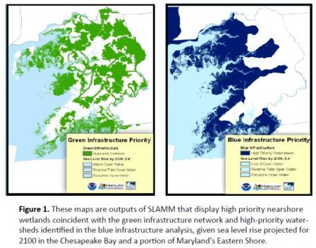
 High Priority Conservation Areas Identified from the SLAMM Analysis.Maryland, a state many consider synonymous with coastal life and livelihoods, has already experienced the loss of several islands and vast acreage of shoreline due to erosion and sea level rise. Maryland’s coastal wetlands are particularly vulnerable to projected climate changes and are already experiencing threats from storms, inundation, and sea level rise –which is occurring at nearly twice the global average-. Accordingly, Maryland’s Department of Natural Resources (MDNR), in partnership with the Maryland Department of the Environment (MDE), has sought to implement wetland restoration and conservation programs to protect the state’s remaining coastal wetlands from climate change.
Maryland used the Sea Level Affecting Marshes Model (SLAMM) to factor in sea level rise projections and gain a comprehensive look at coastal wetland areas throughout the state. This analysis is allowing the state to better identify the wetland migration areas under future sea level rise conditions and identify high priority wetland areas for protection. Data on wetland characteristics including size, species composition, and ecosystem connectivity has helped inform adaptation options by helping identify and prioritize land necessary for preserving current and future ecosystem diversity and functionality. The analysis enabled MDNR officials to provide information on high priority and vulnerable areas for conservation purposes to land managers, conservation planners, and the public. Consequently, this analysis provides land use planners and conservation organizations valuable information to help preserve areas for wetland migration and adapt to higher sea-levels.
| How Did They Do It? | Applicable EPA Tools |
|---|---|
Acknowledged the threat and devised a strategy to analyze vulnerability
|
The Scenario Based Projected Changes Map can illustrate scenarios of projected changes in annual precipitation, 100-year storm events, and sea-level rise to identify climate threats to the coast. |
Maryland developed an analysis to identify areas for current and future acquisition to spur climate adaptation of coastal wetlands
|
Download the Sea Level Affecting Marsh Model (SLAMM Tool) from the U.S. Climate Resiliency Toolkit to help analyze wetland migration under projected sea level rise. |
Identified “Targeted Ecological Areas” that would provide potential migration zones and integrated adaptation criteria into existing programs
|
Synthesis of Adaptation Options for Coastal Areas Guidebook helps identify climate risks to coastal ecosystems and review adaptation options available to coastal managers. Synthesis of Adaptation Options for Coastal Areas Guidebook The Rolling Easements Primer can help identify more than a dozen land use and legal tools for ensuring that intertidal habitats can persist even as sea level rises. |
Similar Cases and More Information
For more information view the EPA’s 2015 State Water Agency Practices for Climate Adaptation – Maryland Document or view the U.S. Climate Resiliency Toolkit Case Study. To see another example of how a coastal community assessed their vulnerability view the Southwest Florida Salt Marsh Vulnerability and Adaptation Plan, or the San Juan Estuary Vulnerability Assessment. To learn more about how climate changes can affect natural resources and threaten drinking water availability through saltwater intrusion, see how Tampa Bay Water diversified their source water to promote resiliency to current and future conditions.
- 2015 State Water Agency Practices for Climate Adaptation – Maryland Document
- U.S. Climate Resiliency Toolkit Case Study
- Southwest Florida Salt Marsh Vulnerability and Adaptation Plan
- San Juan Estuary Vulnerability Assessment
- Tampa Bay Diversifies Water Sources to Reduce Climate Risk
References
- Maryland Department of Natural Resources Exit
- Adapting to Climate Change & Sea Level Rise: A Maryland Statewide SurveyExit
- State Water Agency Practices for Climate Adaptation Database
- Comprehensive Strategy for Reducing Maryland’s Vulnerability to Climate Change (PDF)(40 pp, 12.5 MB) Exit
- Comprehensive Strategy Phase 1 (PDF) (44 pp, 12.4 MB) Exit
- Coastal Land Conservation in Maryland: Targeting Tools and Techniques for Sea Level Rise Adaptation and Response (PDF) (76 pp, 3.4 MB) Exit

