Ecoregion Download Files by State - Region 10
Select a state for descriptive information about that state's Level III and IV ecoregions. Additionally, each state section contains links to downloadable maps in PDF format, and files containing GIS datasets (shapefiles, metadata, and symbology data).
Some Web content for Level IV Ecoregions is under construction. If you do not find a link to a state that has been completed, maps and GIS data are available on the Ecoregion FTP site and web content will be available shortly.
NOTE: maps and GIS files may differ. To make sure you are using the most current ecoregion data, download shapefiles of ecoregions.
- Alaska
GIS Data (shapefiles, metadata and symbology)
- Alaska Level III Shapefile (3 mb)
- Alaska Level III Metadata and Alaska Level III Symbology
- Instructions for applying symbology to ecoregions
Maps (available in PDF format)
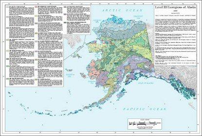
- Level III Ecoregions of Alaska--map and descriptions 32" X 24" (20 mb)
- Original Level III Ecoregions of Alaska--map and descriptions front side 41" X 22" (7 mb)
- Original Level III Ecoregions of Alaska back side 20" X 21" (2 mb)
This map of ecoregions has been produced for Alaska as a framework for organizing and interpreting environmental data for State, national, and international level inventory, monitoring, and research efforts. The map and descriptions for 20 ecological regions were derived by synthesizing information on the geographic distribution of environmental factors such as climate, physiography, geology, permafrost, soils, and vegetation. A qualitative assessment was used to interpret the distributional patterns and relative importance of these factors from place to place (Gallant and others, 1995). Numeric identifiers assigned to the ecoregions are coordinated with those used on the map of “Ecoregions of the Conterminous United States” (Omernik 1987, U.S. EPA 2010) as a continuation of efforts to map ecoregions for the United States. Additionally, the ecoregions for Alaska and the conterminous United States, along with ecological regions for Canada (Wiken 1986) and Mexico, have been combined for maps at three hierarchical levels for North America (Omernik 1995, Commission for Environmental Cooperation, 1997, 2006). Comments regarding this map should be addressed to James Omernik, U.S. Geological Survey, 200 SW 35th Street, Corvallis, OR 97333, (541) 754-4458, omernik.james@epa.gov; or Glenn Griffith, U.S Geological Survey, 200 SW 35th Street, Corvallis, OR 97333, (541) 754-4465, griffith.glenn@epa.gov.
Literature Cited:
Commission for Environmental Cooperation, 1997, Ecological regions of North America – toward a common perspective: Montreal, Commission for Environmental Cooperation, 71 p.
Commission for Environmental Cooperation, 2006, Ecological regions of North America, Level III, Map scale 1:10,000,000, http://www.epa.gov/wed/pages/ecoregions/na_eco.htm.
Gallant, A.L., Binnian, E.F. Omernik, J.M. and Shasby, M.B., 1995, Ecoregions of Alaska: U.S. Geological Survey Professional Paper 1567.
Omernik, J.M., 1987, Ecoregions of the Conterminous United States: Annals of the Association of American Geographers, v. 77, no.1, p. 118-125.
Omernik, J.M., 1995, Ecoregions: a Framework for Managing Ecosystems: The George Wright Forum, v. 12, no.1, p. 35-51.
U.S. Environmental Protection Agency, 2010, Level III ecoregions of the continental United States (revision of Omernik, 1987): Corvallis, Oregon, USEPA – National Health and Environmental Effects Research Laboratory, Map M-1, various scales.
Wiken, E.B., 1986, Terrestrial Ecozones of Canada: Lands Directorate, Environmental Canada Ecological Land Classification Series 19, 26 p.
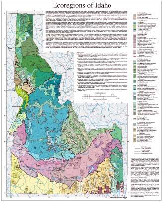
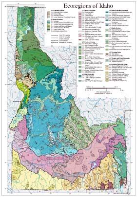
- Idaho
GIS Data (shapefiles, metadata and symbology)
- Idaho Level III Shapefile (479 kb)
- Idaho Level III Metadata and Idaho Level III Symbology
- Idaho Level IV Shapefile (1.9 mb)
- Idaho Level IV Metadata and Idaho Level IV Symbology
- Instructions for applying symbology to ecoregions
Maps (available in PDF format)
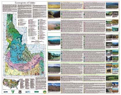
- Level IV Ecoregions of Idaho--poster front side 46" X 36" (6.2 mb)
- Level IV Ecoregions of Idaho--poster back side 46" X 36" (92 kb)
- Level III and IV Ecoregions of Idaho--24" X 26" (1.7 mb)
- Level III and IV Ecoregions of Idaho--page size (1.8 mb)
Ecoregions denote areas of general similarity in ecosystems and in the type, quality, and quantity of environmental resources; they are designed to serve as a spatial framework for the research, assessment, management, and monitoring of ecosystems and ecosystem components. By recognizing the spatial differences in the capacities and potentials of ecosystems, ecoregions stratify the environment by its probable response to disturbance (Bryce and others, 1999). These general purpose regions are critical for structuring and implementing ecosystem management strategies across federal agencies, state agencies, and nongovernment organizations that are responsible for different types of resources within the same geographical areas (Omernik and others, 2000).
The approach used to compile this map is based on the premise that ecological regions can be identified through the analysis of the spatial patterns and the composition of biotic and abiotic phenomena that affect or reflect differences in ecosystem quality and integrity (Wiken, 1986; Omernik, 1987, 1995). These phenomena include geology, physiography, vegetation, climate, soils, land use, wildlife, and hydrology.
The relative importance of each characteristic varies from one ecological region to another regardless of the hierarchical level. A Roman numeral hierarchical scheme has been adopted for different levels of ecological regions. Level I is the coarsest level, dividing North America into 15 ecological regions. Level II divides the continent into 52 regions (Commission for Environmental Cooperation Working Group, 1997). At level III, the continental United States contains 104 ecoregions and the conterminous United States has 84 ecoregions (United States Environmental Protection Agency [USEPA], 2000). Level IV is a further subdivision of level III ecoregions. Explanations of the methods used to define the USEPA’s ecoregions are given in Omernik (1995), Omernik and others (2000), Griffith and others (1994), and Gallant and others (1989).
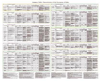
Idaho is made up of semiarid shrub- and grass-covered plains, irrigated agricultural valleys, volcanic plateaus, forested mountains, woodland- and shrubland-covered hills, glaciated peaks, lava fields, and wetlands. Ecological diversity is enormous. There are 10 level III ecoregions and 71 level IV ecoregions in Idaho and many continue into ecologically similar parts of adjacent states.
The level III and IV ecoregion map on this poster was compiled at a scale of 1:250,000 and depicts revisions and subdivisions of earlier level III ecoregions that were originally compiled at a smaller scale (USEPA, 2000; Omernik, 1987). This poster is part of a collaborative project primarily between USEPA Region X, USEPA National Health and Environmental Effects Research Laboratory (Corvallis, Oregon), Idaho Division of Environmental Quality (IDEQ), United States Department of Agriculture–Forest Service (USFS), United States Department of Agriculture–Natural Resources Conservation Service (NRCS), United States Department of the Interior–Bureau of Land Management (BLM), and United States Department of the Interior–Geological Survey (USGS)–Earth Resources Observation Systems (EROS) Data Center.
The project is associated with an interagency effort to develop a common framework of ecological regions. Reaching that objective requires recognition of the differences in the conceptual approaches and mapping methodologies applied to develop the most common ecoregion-type frameworks, including those developed by the USFS (Bailey and others, 1994), the USEPA (Omernik, 1987, 1995), and the NRCS (U.S. Department of Agriculture–Soil Conservation Service, 1981). As each of these frameworks is further refined, their differences are becoming less discernible. Regional collaborative projects such as this one in Idaho, where agreement has been reached among multiple resource management agencies, are a step toward attaining consensus and consistency in ecoregion frameworks for the entire nation.
Literature Cited:
Bailey, R.G., Avers, P.E., King, T., and McNab, W.H., eds., 1994, Ecoregions and subregions of the United States (map) (supplementary table of map unit descriptions compiled and edited by McNab, W.H. and Bailey, R.G.): Washington, D.C., USFS, scale 1:7,500,000.
Bryce, S.A., Omernik, J.M., and Larsen, D.P., 1999, Ecoregions – a geographic framework to guide risk characterization and ecosystem management: Environmental Practice, v. 1, no. 3, p. 141-155.
Commission for Environmental Cooperation Working Group, 1997, Ecological regions of North America – toward a common perspective: Montreal, Commission for Environmental Cooperation, 71 p.
Gallant, A.L., Whittier, T.R., Larsen, D.P., Omernik, J.M., and Hughes, R.M., 1989, Regionalization as a tool for managing environmental resources: Corvallis, Oregon, U.S. Environmental Protection Agency, EPA/600/3-89/060, 152 p.
Griffith, G.E., Omernik, J.M., Wilton, T.F., and Pierson, S.M., 1994, Ecoregions and subregions of Iowa – a framework for water quality assessment and management: Journal of the Iowa Academy of Science, v. 101, no. 1, p. 5-13.
Omernik, J.M., 1987, Ecoregions of the conterminous United States (map supplement): Annals of the Association of American Geographers, v. 77, no. 1, p. 118-125, scale 1:7,500,000.
Omernik, J.M., 1995, Ecoregions – a framework for environmental management, in Davis, W.S. and Simon, T.P., eds., Biological assessment and criteria-tools for water resource planning and decision making: Boca Raton, Florida, Lewis Publishers, p. 49-62.
Omernik, J.M., Chapman, S.S., Lillie, R.A., and Dumke, R.T., 2000, Ecoregions of Wisconsin: Transactions of the Wisconsin Academy of Sciences, Arts, and Letters, v. 88, p. 77-103.
U.S. Department of Agriculture–Soil Conservation Service, 1981, Land resource regions and major land resource areas of the United States: Agriculture Handbook 296, 156 p.
U.S. Environmental Protection Agency, 2000, Level III ecoregions of the continental United States (revision of Omernik, 1987): Corvallis, Oregon, USEPA – National Health and Environmental Effects Research Laboratory, Map M-1, various scales.
Wiken, E., 1986, Terrestrial ecozones of Canada: Ottawa, Environment Canada, Ecological Land Classification Series no. 19, 26 p.
PRINCIPAL AUTHORS: Chad L. McGrath (NRCS), Alan J. Woods (Dynamac Corporation), James M. Omernik (USEPA), Sandra A. Bryce (Dynamac Corporation), Mike Edmondson (IDEQ), John A. Nesser (USFS), James Shelden (USFS), Rex C. Crawford (Washington Department of Natural Resources), Jeffrey A. Comstock (Indus Corporation), and Milton D. Plocher (Dynamac Corporation).
COLLABORATORS AND CONTRIBUTORS: Erwin Cowley (BLM), Carl Davis (USFS), Don A. Essig (IDEQ), Jerry Freeouf (USFS), Pat Green (USFS), Glenn Griffith (NRCS), Jimmy Kagan (Oregon Natural Heritage Program), Scott Lambert (Washington State University), Duane A. Lammers (USFS), John Lott (USFS), Thomas R. Loveland (USGS), Terry Maret (USGS), Michael McIntyre (IDEQ), Christopher Mebane (IDEQ), Neil Peterson (NRCS), Thor D. Thorson (NRCS), and Bill Ypsilantis (BLM).
REVIEWERS: Arthur C. Zack (USFS, Idaho Panhandle National Forest), Gerald J. Niehoff (USFS, Idaho Panhandle National Forest), and Thomas M. Rice (USFS, Rocky Mountain Research Station).
CITING THIS POSTER: McGrath C.L., Woods A.J., Omernik, J.M., Bryce, S.A., Edmondson, M., Nesser, J.A., Shelden, J., Crawford, R.C., Comstock, J.A., and Plocher, M.D., 2002, Ecoregions of Idaho (color poster with map, descriptive text, summary tables, and photographs): Reston, Virginia, U.S. Geological Survey (map scale 1:1,350,000).
This project was partially supported by funds from the USEPA-Office of Research and Development's Environmental Monitoring and Assessment Program through contract 68-C6-005 to Dynamac Corporation.
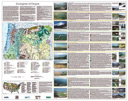
- Oregon
GIS Data (shapefiles, metadata and symbology)
- Oregon Level III Shapefile (409 kb)
- Oregon Level III Metadata and Oregon Level III Symbology
- Oregon Level IV Shapefile (1.73 mb)
- Oregon Level IV Metadata and Oregon Level IV Symbology
- Instructions for applying symbology to ecoregions
Maps (available in PDF format)
- Level IV Ecoregions of Oregon--poster front side 46" X 36" (7.5 mb)
- Level IV Ecoregions of Oregon--poster back side 46" X 36" (712 kb)
- Level III and IV Ecoregions of Oregon--24" X 26" (1.8 mb)
- Level III and IV Ecoregions of Oregon--page size (1.8 mb)
Ecoregions denote areas of general similarity in ecosystems and in the type, quality, and quantity of environmental resources; they are designed to serve as a spatial framework for the research, assessment, management, and monitoring of ecosystems and ecosystem components. By recognizing the spatial differences in the capacities and potentials of ecosystems, ecoregions stratify the environment by its probable response to disturbance (Bryce and others, 1999). Ecoregions are directly applicable to the immediate needs of state agencies, including the development of biological criteria and water quality standards and the establishment of management goals for nonpoint-source pollution (Omernik and Griffith, 1991; Hughes and others, 1990; Whittier and others, 1988). They are also relevant to integrated ecosystem management, an ultimate goal of many federal and state resource management agencies.
The approach used to compile this map is based on the premise that ecological regions can be identified through the analysis of the spatial patterns and the composition of biotic and abiotic phenomena that affect or reflect differences in ecosystem quality and integrity (Wiken, 1986; Omernik, 1987, 1995). These phenomena include geology, physiography, vegetation, climate, soils, land use, wildlife distributions, and hydrology. The relative importance of each characteristic varies from one ecological region to another regardless of the hierarchical level. A Roman numeral hierarchical scheme has been adopted for different levels of ecological regions. Level I is the coarsest level, dividing North America into 15 ecological regions. Level II divides the continent into 52 regions (Commission for Environmental Cooperation Working Group, 1997). At level III, the continental United States contains 104 ecoregions and the conterminous United States has 84 ecoregions (United States Environmental Protection Agency [USEPA], 2003). Level IV is a further subdivision of level III ecoregions. Explanations of the methods used to define the USEPA’s ecoregions are given in Omernik (1995), Omernik and others (2000), Griffith and others (1994), and Gallant and others (1989).
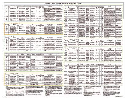
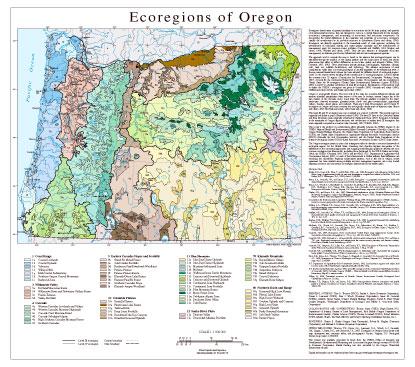
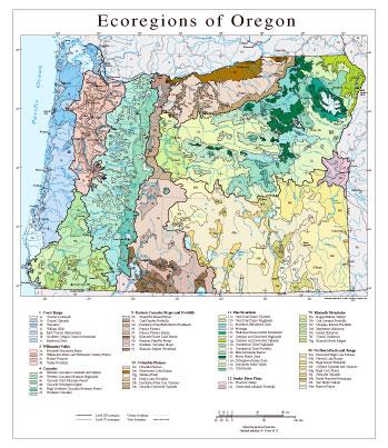
Oregon is ecologically diverse. The west side of the state has a marine-influenced climate and receives plentiful precipitation three seasons of the year. In contrast, eastern Oregon lies in the rain shadow of the Cascades and is much drier. The climatic gradient is evident in the state's landscapes: forested mountains, glaciated peaks, shrub- and grass-covered plains, agricultural valleys, beaches, desert playas, and wetlands. There are 9 level III ecoregions and 65 level IV ecoregions in Oregon and many continue into ecologically similar parts of adjacent states (Bryce and others, 2003; McGrath and others, 2002; Pater and others, 1998).
This level III and IV ecoregion map was compiled at a scale of 1:250,000. The western part was originally published as part of Pater and others (1998). The level IV lines in the Columbia Plateau and Blue Mountains were originally published in Clarke and Bryce (1997). Ecoregion boundaries in the remainder of Oregon depict revisions and subdivisions of earlier level III ecoregions that were originally compiled at a coarser scale (Omernik, 1987; USEPA, 2003).
This poster is the product of a collaborative effort primarily between the USEPA Region X, the USEPA National Health and Environmental Effects Research Laboratory (Corvallis, Oregon), the Oregon Natural Heritage Program, the United States Department of Agriculture–Forest Service (USFS), the United States Department of Agriculture–Natural Resources Conservation Service (NRCS) (formerly the Soil Conservation Service), and the United States Department of the Interior–Geological Survey (USGS)–Earth Resources Observation Systems (EROS) Data Center.
The Oregon ecoregion project is part of an interagency effort to develop a common framework of ecological regions for the United States. Reaching that objective requires recognition of the differences in the conceptual approaches and mapping methodologies applied to develop the most common ecoregion-type frameworks, including those developed by the USFS (Bailey and others, 1994), the USEPA (Omernik, 1987, 1995), and the NRCS (U.S. Department of Agriculture–Soil Conservation Service, 1981). As each of these frameworks is further refined, their differences are becoming less discernible. Regional collaborative projects, such as this one in Oregon, where agreement has been reached among multiple resource management agencies, are a step toward attaining consensus and consistency in ecoregion frameworks for the entire nation.
Literature Cited:
Bailey, R.G., Avers, P.E., King, T., and McNab, W.H., eds., 1994, Ecoregions and subregions of the United States (map) (supplementary table of map unit descriptions compiled and edited by McNab, W.H. and Bailey, R.G.): Washington, D.C., USFS, scale 1:7,500,000.Bryce, S.A., Omernik, J.M., and Larsen, D.P., 1999, Ecoregions – a geographic framework to guide risk characterization and ecosystem management: Environmental Practice, v. 1, no. 3, p. 141-155.
Bryce, S.A., Woods A.J., Morefield, J.D., Omernik, J.M., McKay, T.R., Brackley, G.K., Hall, R.K., Higgins, D.K., McMorran, D.C., Vargas, K.E., Petersen, E.B., Zamudio, D.C., and Comstock, J.A., 2003, Ecoregions of Nevada: Reston, Virginia, U.S. Geological Survey, map scale 1:1,350,000.
Clarke, S.E., and Bryce, S.A., eds., 1997, Hierarchical subdivisions of the Columbia Plateau and Blue Mountains Ecoregions, Oregon and Washington: Portland, Oregon, USFS, Pacific Northwest Research Station, General Technical Report PNW-GTR-395.
Commission for Environmental Cooperation Working Group, 1997, Ecological regions of North America – toward a common perspective: Montreal, Commission for Environmental Cooperation, 71 p.
Gallant, A.L., Whittier, T.R., Larsen, D.P., Omernik, J.M., and Hughes, R.M., 1989, Regionalization as a tool for managing environmental resources: Corvallis, Oregon, U.S. Environmental Protection Agency, EPA/600/3-89/060, 152 p.
Griffith, G.E., Omernik, J.M., Wilton, T.F., and Pierson, S.M., 1994, Ecoregions and subregions of Iowa – a framework for water quality assessment and management: Journal of the Iowa Academy of Science, v. 101, no. 1, p. 5-13.
Hughes, R.M., Whittier, T.R., Rohm, C.M., and Larsen, D.P., 1990, A regional framework for establishing recovery criteria: Environmental Management, v. 14, no. 5, p. 673-683.
McGrath, C.L., Woods A.J., Omernik, J.M., Bryce, S.A., Edmondson, M., Nesser, J.A., Shelden, J., Crawford, R.C., Comstock, J.A., and Plocher, M.D., 2002, Ecoregions of Idaho: Reston, Virginia, U.S. Geological Survey, map scale 1:1,350,000.
Omernik, J.M., 1987, Ecoregions of the conterminous United States (map supplement): Annals of the Association of American Geographers, v. 77, no. 1, p. 118-125, scale 1:7,500,000.
Omernik, J.M., 1995, Ecoregions – a framework for environmental management, in Davis, W.S. and Simon, T.P., eds., Biological assessment and criteria-tools for water resource planning and decision making: Boca Raton, Florida, Lewis Publishers, p. 49-62.
Omernik, J.M., Chapman, S.S., Lillie, R.A., and Dumke, R.T., 2000, Ecoregions of Wisconsin: Transactions of the Wisconsin Academy of Sciences, Arts, and Letters, v. 88, p. 77-103.
Omernik, J.M. and Griffith, G.E., 1991, Ecological regions vs. hydrologic units: frameworks for managing water quality: Journal of Soil and Water Conservation, v. 46, no. 5, p. 334-340.
Pater, D.E., Bryce, S.A., Thorson, T.D., Kagan, J., Chappell, C., Omernik, J.M., Azevedo, S.H., and Woods, A.J., 1998, Ecoregions of Western Washington and Oregon: Reston, Virginia, U.S. Geological Survey, map scale 1:1,350,000.
U.S. Department of Agriculture–Soil Conservation Service, 1981, Land resource regions and major land resource areas of the United States: Agriculture Handbook 296, 156 p.
U.S. Environmental Protection Agency, 2003, Level III ecoregions of the continental United States (revision of Omernik, 1987): Corvallis, Oregon, USEPA – National Health and Environmental Effects Research Laboratory, Map M-1, various scales.
Wiken, E., 1986, Terrestrial ecozones of Canada: Ottawa, Environment Canada, Ecological Land Classification Series no. 19, 26 p.
Whittier, T.R., Hughes, R.M., and Larsen, D.P., 1988, Correspondence between ecoregions and spatial patterns in stream ecosystems in Oregon: Canadian Journal of Fisheries and Aquatic Sciences, v. 45, p. 1264-1278.
PRINCIPAL AUTHORS: Thor D. Thorson (NRCS), Sandra A. Bryce (Dynamac Corporation), Duane A. Lammers (USFS), Alan J. Woods (Dynamac Corporation), James M. Omernik (USEPA, retired), Jimmy Kagan (Oregon Natural Heritage Program), David E. Pater (Water Quality Program, Washington Department of Ecology), and Jeffrey A. Comstock (Indus Corporation).
COLLABORATORS AND CONTRIBUTORS: Thomas Atzet (USFS), Hugh Barrett (U.S. Department of Interior, Bureau of Land Management), Rick Hafele (Oregon Department of Environmental Quality), Charles Johnson (USFS), Thomas Loveland (USGS), Robert Meurisse (USFS, retired), Chad L. McGrath (NRCS), and Robert Ottersberg (Cordilleran Services, Inc.).
REVIEWERS: Sharon E. Clarke (Oregon State University), Robert M. Hughes (Dynamac Corporation), and Michael A. Bollman (Dynamac Corporation).
CITING THIS POSTER: Thorson, T.D., Bryce, S.A., Lammers, D.A., Woods, A.J., Omernik, J.M., Kagan, J., Pater, D.E., and Comstock, J.A., 2003. Ecoregions of Oregon (color poster with map, descriptive text, summary tables, and photographs): Reston, Virginia, U.S. Geological Survey (map scale 1:1,500,000).
This project was partially supported by funds from the USEPA–Office of Research and Development's Environmental Monitoring and Assessment Program through contract 68-C6-005 to Dynamac Corporation. Partial funding was also provided by the Oregon Watershed Enhancement Board. - Washington
GIS Data (shapefiles, metadata and symbology)
- Washington Level III Shapefile (3 mb)
- Washington Level III Metadata and Washington Level III Symbology
- Washington Level IV Shapefile (3 mb)
- Washington Level IV Metadata and Washington Level IV Symbology
- Instructions for applying symbology to ecoregions
Maps (available in PDF format)
Map Thumbnail 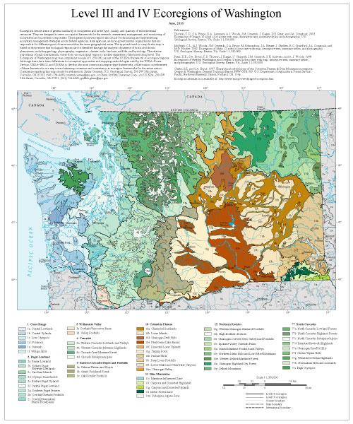 Level III and IV Ecoregions of Washington--map 20" X 24" (8 mb)
Ecoregions denote areas of general similarity in ecosystems and in the type, quality, and quantity of environmental resources. They are designed to serve as a spatial framework for the research, assessment, management, and monitoring of ecosystems and ecosystem components. These general purpose regions are critical for structuring and implementing ecosystem management strategies across federal agencies, state agencies, and non-governmental organizations that are responsible for different types of resources within the same geographical areas. The approach used to compile this map is based on the premise that ecological regions can be identified through the analysis of patterns of biotic and abiotic phenomena, including geology, physiography, vegetation, climate, soils, land use, wildlife, and hydrology. The relative importance of each characteristic varies from one ecological region to another regardless of the hierarchical level. The Ecoregions of Washington map was compiled at a scale of 1:250,000, as part of the US EPA framework of ecological regions. Although there have been differences in conceptual approaches and mapping methodologies used by the USDA–Forest Service, USDA–NRCS, and US EPA to develop the most common ecoregion-type frameworks, collaboration on refinement of these frameworks is a step toward attaining consensus and consistency in ecoregion frameworks for the entire nation. Comments regarding this map should be addressed to James Omernik, U.S. Geological Survey, 200 SW 35th Street, Corvallis, OR 97333, (541) 754-4458, omernik.james@epa.gov; or Glenn Griffith, Dynamac Corp., c/o US EPA, 200 SW 35th Street, Corvallis, OR 97333, (541) 754-4465, griffith.glenn@epa.gov.
Literature Cited:
Thorson, T.D., S.A. Bryce, D.A. Lammers, A.J. Woods, J.M. Omernik, J. Kagan, D.E. Pater, and J.A. Comstock. 2003. Ecoregions of Oregon. (2 sided color poster with map, descriptive text, summary tables, and photographs). U.S. Geological Survey, Reston, VA. Scale 1:1,500,000.
McGrath, C.L., A.J. Woods, J.M. Omernik, S.A. Bryce, M. Edmondson, J.A. Nesser, J. Shelden, R.C. Crawford, J.A. Comstock, and M.D. Plocher. 2002. Ecoregions of Idaho. (2 sided color poster with map, descriptive text, summary tables, and photographs). U.S. Geological Survey, Reston, VA. Scale 1:1,350,000.
Pater, D.E., S.A. Bryce, T.D. Thorson, J. Kagan, C. Chappell, J.M. Omernik, S.H. Azevedo, and A. J. Woods. 1998. Ecoregions of Western Washington and Oregon (2 sided color poster with map, descriptive text, summary tables, and photographs). U.S. Geological Survey, Reston, VA. Scale 1:1,350,000.
Clarke, S.E. and S.A. Bryce. 1997. Hierarchical subdivisions of the Columbia Plateau & Blue Mountains ecoregions, Oregon & Washington. General Technical Report PNW-GTR-395. U.S. Department of Agriculture, Forest Service, Pacific Northwest Research Station, Portland, OR. 114p.