Ecoregion Download Files by State - Region 2
Select a state (click on one of the gray bars below) for descriptive information about that state's Level III and IV ecoregions. Additionally, each state section contains links to downloadable maps in PDF format, and files containing GIS datasets (shapefiles, metadata, and symbology data).
Some Web content for Level IV Ecoregions is under construction. If you do not find a link to a state that has been completed, maps and GIS data are available on the Ecoregion FTP site and web content will be available shortly.
NOTE: maps and GIS files may differ. To make sure you are using the most current ecoregion data, download shapefiles of ecoregions.
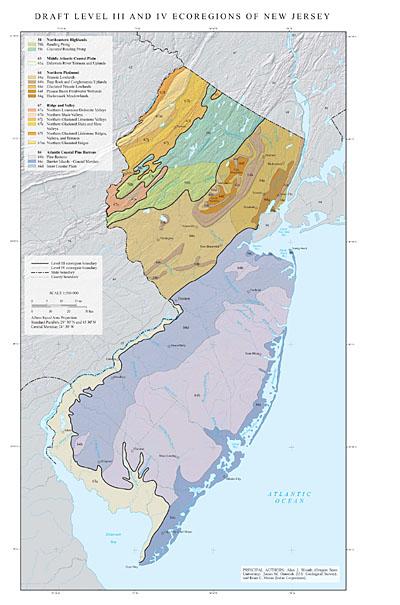
- New Jersey
GIS Data (shapefiles, metadata and symbology)
- New Jersey Level III Shapefile (1.05 mb)
- New Jersey Level III Metadata and New Jersey Level III Symbology
- New Jersey Level IV Shapefile (1.06 mb)
- New Jersey Level IV Metadata and New Jersey Level IV Symbology
- Instructions for applying symbology to ecoregions
Maps (available in PDF format)
- Level IV Ecoregions of New Jersey 16 X 26" (664 kb)
- Level III and IV Ecoregions of New Jersey text descriptions and bibliography
 Level IV Ecoregions of New Jersey 16 X 26" (664 kb)
Ecoregions denote areas of general similarity in ecosystems, and in the type, quality, and quantity of environmental resources. They are general purpose regions that are useful for structuring and implementing ecosystem management strategies across political boundaries (such as state lines) and across agencies (Omernik and others, 2000). Ecoregions stratify the environment according to its probable response to disturbance, and recognize the spatial differences in the capacities and potentials of ecosystems (Bryce, Omernik, and Larsen, 1999).
Ecoregion frameworks are useful for 1) inventorying and assessing national and regional environmental resources, 2) setting regional resource management goals, 3) establishing geographical research frameworks, and 4) developing regional biological criteria and water quality standards (Arkansas Department of Pollution Control and Ecology, 1988; Bazata, 1991; Environment Canada, 1989; Gallant and others, 1989; Heiskary and Wilson, 1989; Hughes, 1989b; Hughes and others, 1987, 1990, 1994; Larsen and others, 1986; Lyons, 1989; Ohio Environmental Protection Agency, 1988; Plotnikoff, 1992; Rohm and others, 1987; U.S. Environmental Protection Agency, Science Advisory Board, 1991; Warry and Hanau, 1993; Whittier and others, 1988).
Ecoregion frameworks have been developed for several countries, including the United States, Canada, New Zealand, and the Netherlands (Bailey, 1976, 1983, 1995; Bailey and others, 1985, 1994; Biggs and others, 1990; Ecological Stratification Working Group, 1995; Klijn, 1994; Omernik, 1987, 1995a; Omernik and Gallant, 1990; U.S. Environmental Protection Agency, 2005; Wiken, 1986). The first compilation of ecoregions in the conterminous United States by the U.S. Environmental Protection Agency (U.S. EPA) was performed at a relatively cursory scale (1:3,168,000), and was published at a smaller scale (1:7,500,000) (Omernik, 1987). Subsequently, this ecoregion framework was expanded to include Alaska and all of North America, revised, and made hierarchical (Gallant and others, 1995; Omernik, 1995b; U.S. Environmental Protection Agency, 2005).
Level I is the coarsest level in the ecoregion hierarchy; it divides North America into 15 ecological regions. Level II divides the continent into 50 regions. At level III, the continental United States contains 104 ecoregions, whereas the conterminous United States has 84. Level IV ecological regions are further subdivisions of level III ecoregions. The exact number of ecological regions at each hierarchical level is still changing slightly as the framework undergoes development at the international, national, and state levels.
Detail resolution on Omernik’s (1987) ecoregion map of the conterminous United States was necessarily limited by its rather small scale of 1:7,500,000. Subsequently, many larger scale, collaborative, state projects refined Omernik’s original ecoregion map, and subdivided its level III ecoregions into level IV ecoregions. Completed level IV ecoregion projects cover Alabama, Arkansas, Colorado, Delaware, Florida, Georgia, Idaho, Illinois, Indiana, Iowa, Kansas, Kentucky, Louisiana, Maryland, Mississippi, Missouri, Montana, Nebraska, Nevada, North Carolina, North Dakota, Ohio, Oklahoma, Oregon, Pennsylvania, South Carolina, South Dakota, Tennessee, Texas, Utah, Virginia, Washington, West Virginia, Wisconsin, and Wyoming. Other state level IV ecoregion projects are in the draft phase including Connecticut, Massachusetts, Minnesota, New Mexico, and Rhode Island. These level IV ecoregion projects have involved state agencies, U.S. EPA regional offices, and the U.S. EPA–National Health and Environmental Effects Research Laboratory, Western Ecology Division in Corvallis, Oregon. Projects have included participation by the U.S. Department of Agriculture–Natural Resources Conservation Service and the U.S. Department of Agriculture–Forest Service as part of an interagency effort to develop a common framework of ecological regions.
In this paper we refine the level III ecoregions of New Jersey, subdivide them into more detailed level IV subdivisions, and provide descriptions for each ecoregion in the state. New Jersey has 5 level III and 17 level IV ecoregions; nearly all level IV ecoregions continue into ecologically similar parts of adjacent states (Woods and others, 1996; Woods and Omernik, 1996).
The procedures used to define New Jersey ecoregions are consistent with those that were used in preceding U.S. EPA ecoregion studies of neighboring states (Woods and others, 1996; Woods and Omernik, 1996). They are based on the premise that ecological regions can be identified through the analysis of biotic and abiotic characteristics that affect or reflect differences in ecosystem quality and integrity (Omernik, 1987, 1995a; Wiken, 1986). Spatial pattern, composition, and spatial correspondence of physiography, natural vegetation, soil, surficial and bedrock geology, climate, land use, land cover, wildlife, and fish were considered as part of the process. The relative importance of each biotic and abiotic characteristic varied from one ecological region to another regardless of the ecoregion hierarchical level. Expert judgment was employed throughout the selection, analysis, and classification of data to define the ecoregions. Information from the literature and input from state and regional experts were very important to this project, as well as the earlier ones in neighboring states. Ecoregion lines were compiled at 1:250,000-scale onto 1:250,000-scale topographic base maps. More detailed explanations about the methods, materials, rationale, and philosophy for the ecoregionalization process can be found in Gallant and others (1989), Omernik (1995a), and Omernik and Gallant (1990).
Evaluation of the ecoregion framework presented in this paper is a necessary future step. U.S. EPA ecoregions have been evaluated extensively in the past, and the most meaningful of these efforts have involved the use of measures of water quality and indices of biotic integrity (IBI’s) (Hughes, 1989a; Larsen and others, 1986, 1988; Whittier and others, 1987; Yoder and Rankin, 1995). A better tool would be a more encompassing index of ecological integrity (IEI) (Omernik, 1995a, 1995b); although an IEI is not available yet, there is considerable interest in at least two states to begin its development. Verification of ecoregions cannot be done by considering individual ecosystem components; this is because the ecoregion framework was not intended to show regional patterns specific to either the flora or fauna of terrestrial ecosystems, nor was it intended to reflect distributions of fish or aquatic macroinvertebrates.
Literature Cited:
Arkansas Department of Pollution Control and Ecology, 1988, Regulations establishing water quality standards for surface waters of the State of Arkansas: Little Rock, Arkansas Department of Pollution Control and Ecology.
Bailey, R.G., 1976, Ecoregions of the United States (map): Ogden, Utah, U.S. Department of Agriculture–Forest Service, Intermountain Region, scale 1:7,500,000.
Bailey, R.G., 1983, Delineation of ecosystem regions: Environmental Management. v. 7, p. 365-373.
Bailey, R.G., 1995, Ecosystem Geography: New York: Springer-Verlag.
Bailey, R.G., Avers, P. E., King, T., and McNab, W.H., 1994, Ecoregions and subregions of the United States (map and table): U.S. Department of Agriculture–Forest Service, scale 1:7,500,000.
Bailey, R.G., Zoltai, S.C., and Wiken, E.B., 1985, Ecoregionalization in Canada and the United States: Geoforum, v. 16, no. 3, p. 265-275.
Bazata, K., 1991, Nebraska stream classification study: Lincoln, Nebraska Department of Environmental Control, Water Quality Division, Surface Water Section.
Biggs, B.J.F., Duncan, M.J., Jowett, I.G., Quinn, J.M., Hickey, C.W., Davis-Colley, R.J., and Close, M.E., 1990, Ecological characterization, classification, and modeling of New Zealand rivers – an introduction and synthesis: New Zealand Journal of Marine and Freshwater Research, v. 24, p. 277-304.
Bryce, S.A., Omernik, J.M., and Larsen, D.P., 1999, Ecoregions – a geographic framework to guide risk characterization and ecosystem management: Environmental Practice, v. 1, no. 3, p. 141-155.
Ecological Stratification Working Group, 1995, A National Ecological Framework for Canada (report and national map): Ottawa/Hull, Agriculture and Agri-Food Canada, Research Branch, Centre for Land and Biological Resources Research and Environment Canada, State of the Environment Directorate, Ecozone Analysis Branch, scale 1:7,500,000.
Environment Canada, 1989, Canada Committee on Ecological Land Classification – Achievements (1976-1989) and Long-term Plan: Ottawa, Ontario, Environment Canada.
Gallant, A. L., Binnian, E.F., Omernik, J.M., and Shasby, M.B., 1995, Ecoregions of Alaska: U.S. Geological Survey Professional Paper 1567.
Gallant, A.L., Whittier, T.R., Larsen, D.P., Omernik, J.M., and Hughes, R.M., 1989, Regionalization as a Tool for Managing Environmental Resources: Corvallis, Oregon, U.S. Environmental Protection Agency EPA/600/3-89/060.
Heiskary, S.A., and Wilson, C.B., 1989, The regional nature of lake quality across Minnesota – an analysis for improving resource management: Journal of the Minnesota Academy of Science, v. 55, no. 1, p. 71-77.
Hughes, R.M., 1989a, The IBI – a quantitative, easily communicated assessment of the health and complexity of entire fish communities: Biological Report, v. 90, no. 5, p. 26-28.
Hughes, R.M, 1989b, Ecoregional biological criteria, in Water Quality Standards for the 21st Century: Dallas, Texas, Proceedings of an U.S. Environmental Protection Agency Conference, 147-151.
Hughes, R.M., Whittier, T.R., Rohm, C.M., and Larsen, D.P., 1990, A regional framework for establishing recovery criteria: Environmental Management, v. 14, no. 5, p. 673-683.
Hughes, R.M., Heiskary, S.A., Mathews, W.J., and Yoder, C.O., 1994, Use of ecoregions in biological monitoring in Loeb, S.L., and Spacie, A. (eds.), Biological Monitoring of Aquatic Systems: Boca Raton, Florida, Lewis Publishers, p. 125-151.
Hughes, R.M., Rexstad, E., and Bond, C.E., 1987, The relationship of aquatic ecoregions, river basins, and physiographic provinces to the ichthyogeographic regions of Oregon: Copeia 1987, no. 2, p. 423-432.
Klijn, F., 1994, Spatially nested ecosystems – guidelines for classification from a hierarchical perspective in Klijn, F. (ed.), Ecosystem Classification for Environmental Management: Dordrecht, The Netherlands, Kluwer Academic Publishers, p. 85-116.
Larsen, D.L., Dudley, D.R., and Hughes, R.M., 1988, A regional approach to assess attainable water quality -- an Ohio case study: Journal of Soil and Water Conservation, v. 43, no. 2, p. 171-176.
Larsen, D.P., Hughes, R.M., Omernik, J.M., Dudley, D.R., Rohm, C.M., Whittier, T.R., Kinney, A.J., and Gallant, A.L., 1986, The correspondence between spatial patterns in fish assemblages in Ohio streams and aquatic ecoregions: Environmental Management, v. 10, p. 815-828.
Lyons, J., 1989, Correspondence between the distributions of fish assemblages in Wisconsin streams and Omernik’s ecoregions: American Midland Naturalist, v. 122, no. 1, p. 163-182.
Ohio Environmental Protection Agency, 1988, Biological Criteria for the Protection of Aquatic Life. Volume 1: The Role of biological data in water quality assessment: Columbus, Ohio Environmental Protection Agency.
Omernik, J.M., 1995a, Ecoregions: a spatial framework for environmental management, in Davis, W.S. and Simon, T.P. (eds.), Biological assessment and criteria, tools for water resource planning and decision making: Boca Raton, Florida, Lewis Publishers, p. 31-47.
Omernik, J.M., 1995b, Ecoregions: a framework for managing ecosystems: The George Wright Forum, v. 12, no. 1, p. 35-50.
Omernik, J.M., 1987, Ecoregions of the conterminous United States (map supplement): Annals of the Association of American Geographers, v. 77, no. 1, p. 118-125, map scale 1:7,500,000.
Omernik, J.M., Chapman, S.S., Lillie, R.A., and Dumke. R.T., 2000, Ecoregions of Wisconsin: Transactions of the Wisconsin Academy of Science, Arts and Letters, v. 88, p. 77-103.
Omernik, J.M., and Gallant, A.L., 1990, Defining regions for evaluating environmental resources, in Global natural resource monitoring and assessments – preparing for the 21st century – proceedings of the international conference and workshop, September 24-30, 1989, Fondazione G. Cini, Isle of San Giorgio Maggiore, Venice, Italy, v. 2, 936-947: Bethesda, Maryland, American Society for Photogrammetry and Remote Sensing.
Plotnikoff, R.W., 1992, Timber/Fish/Wildlife Ecoregion Bioassessment Pilot Project: Olympia, Washington Department of Ecology.
Rohm, C.M., Giese, J.W., and Bennett, C.C., 1987, Evaluation of an aquatic ecoregion classification of streams in Arkansas: Journal of Freshwater Ecology, v. 4, no. 1, p. 127-140.
U.S. Environmental Protection Agency, 2005, Level III ecoregions of the continental United States (revision of Omernik, 1987): Corvallis, Oregon: U.S. Environmental Protection Agency–National Health and Environmental Effects Research Laboratory Map M-1, various scales.
U.S. Environmental Protection Agency, Science Advisory Board, 1991, Evaluation of the ecoregion concept. Report of the ecoregions subcommittee of the ecological processes and effects committee: Washington, D.C., U.S. Environmental Protection Agency, EPA/SAB/EPEC/91/003.
Warry, N.D., and Hanau, M., 1993, The use of terrestrial ecoregions as a regional-scale screen for selecting representative reference sites for water quality monitoring: Environmental Management, v. 17, no. 2, p. 267-276.
Whittier, T.R., Hughes, R.M., and Larsen, D.P., 1988, The correspondence between ecoregions and spatial patterns in stream ecosystems in Oregon: Canadian Journal of Fisheries and Aquatic Sciences, v. 45, p. 1264-1278.
Whittier, T.R., Larsen, D.P., Hughes, R.M., Rohm, C.M., Gallant, A.L., and Omernik, J.M., 1987, The Ohio stream regionalization project: a compendium of results: Corvallis, Oregon: U.S. Environmental Protection Agency, Environmental Research Laboratory, EPA/600/3/-87/025.
Wiken, E., 1986, Terrestrial Ecozones of Canada: Ottawa, Canada, Environment Canada, Ecological Land Classification Series No. 19.
Woods, A.J., and Omernik, J.M., 1996, Ecoregions of Pennsylvania: Pennsylvania Geographer, v. XXXIV, no. 2, p. 3-37.
Woods, A.J., Omernik, J.M., Brown, D.D., and Kiilsgaard, C.W., 1996, Level III and IV ecoregions of Pennsylvania and the Blue Ridge Mountains, the Ridge and Valley, and the Central Appalachians of Virginia, West Virginia, and Maryland: Corvallis, OR.: U.S. Environmental Protection Agency, Western Ecology Division, Report EPA/600R-96/077, 50 p.
Yoder, C.O., and Rankin, E.T., 1995, Biological criteria program development and implementation in Ohio, in Davis, W.S., and Simon, T.P. (eds.), Biological assessment and criteria, tools for water resource planning and decision making: Boca Raton, Florida, Lewis Publishers, p. 109-144.
PRINCIPAL AUTHORS: Alan J. Woods (Oregon State University), James M. Omernik (U.S. Geological Survey), and Brian C. Moran (Indus Corporation).
- New York
GIS Data (shapefiles, metadata and symbology)
- New York Level III Shapefile (2.14 mb)
- New York Level III Metadata and New York Level III Symbology
- New York Level IV Shapefile (2.08 mb)
- New York Level IV Metadata and New York Level IV Symbology
- Instructions for applying symbology to ecoregions
Maps (available in PDF format)
- Level III and IV Ecoregions of New York-- poster front side 45 X 35" (22 mb)
- Summary Table: Characteristics of the Ecoregions of New York-- poster back side 46 X 36" (433 kb)
Map Thumbnails 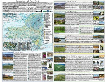 Level III and IV Ecoregions of New York-- poster front side 45 X 35" (22 mb)
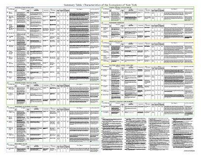 Summary Table: Characteristics of the Ecoregions of New York-- poster back side 46 X 36" (433 kb)
Ecoregions denote areas of general similarity in ecosystems and in the type, quality, and quantity of environmental resources; they are designed to serve as a spatial framework for research, assessment, management, and monitoring of ecosystems and ecosystem components. By recognizing the spatial differences in the capacities and potentials of ecosystems, ecoregions stratify the environment by its probable response to disturbance (Bryce and others, 1999). These general purpose ecological regions are critical for structuring and implementing ecosystem management strategies across federal agencies, state agencies, and nongovernmental organizations that are responsible for different types of resources within the same geographical areas (Omernik and others, 2000).
The New York ecoregion map was compiled at a scale of 1:250,000. It revises and subdivides an earlier national ecoregion map that was originally compiled at a smaller scale (USEPA, 2009; Omernik, 1987). The approach used to compile this map is based on the premise that ecological regions can be identified through the analysis of the composition and spatial pattern of biotic and abiotic phenomena that affect or reflect differences in ecosystem quality and integrity (Wiken, 1986; Omernik, 1987, 1995). These phenomena include geology, physiography, vegetation, climate, soils, land use, wildlife, and hydrology. The relative importance of each characteristic varies from one ecological region to another regardless of its hierarchical level.
A Roman numeral hierarchical scheme distinguishes the different levels of ecological regions. Level I is the coarsest level, dividing North America into 15 ecological regions. Level II divides the continent into 50 regions (Commission for Environmental Cooperation Working Group, 1997). The continental United States contains 104 level III ecoregions and the conterminous United States has 84 ecoregions (United States Environmental Protection Agency [USEPA], 2009). Level IV is a further subdivision of level III ecoregions. Explanations of the methods used to define the USEPA's ecoregions may be found in Omernik (1995, 2004), and Omernik and others (2000).
New York contains great ecological diversity in its low coastal plains, large river valleys, rolling plateaus, glacial lakes, forested mountains, and alpine peaks. Nine level III ecoregions and 42 level IV ecoregions occur in New York and many continue into ecologically similar parts of adjacent states or provinces.
This poster is part of a collaborative project primarily between USEPA Region 2, USEPA National Health and Environmental Effects Research Laboratory (Corvallis, Oregon), U.S. Department of Agriculture (USDA)-Natural Resources Conservation Service (NRCS), U.S. Geological Survey (USGS)-Earth Resources Observation and Science (EROS) Center, New York Natural Heritage Program (NYNHP), New York State Department of Environmental Conservation (NYSDEC), and The Nature Conservancy. The project is associated with an interagency effort to develop a common framework of ecological regions (McMahon and others, 2001). Reaching that objective requires recognition of the differences in conceptual approaches and mapping methodologies, including those developed by the USDA-Forest Service (Bailey and others, 1994; Cleland and others, 2007), the USEPA (Omernik, 1987, 1995; USEPA 2009), and the USDA-NRCS (USDA-Soil Conservation Service, 1981; USDA-Natural Resources Conservation Service, 2006). As each of these frameworks is further refined, their differences become less discernible. Collaborative ecoregion projects, such as this one in New York, are a step toward attaining consensus and consistency in ecoregion frameworks for the entire nation.
Literature Cited:
Bailey, R.G., Avers, P.E., King, T., and McNab, W.H., eds., 1994, Ecoregions and subregions of the United States (supplementary table of map unit descriptions compiled and edited by McNab, W.H. and Bailey, R.G.): Washington, D.C., U.S. Department of Agriculture-Forest Service, map scale 1:7,500,000.
Bryce, S.A., Omernik, J.M., and Larsen, D.P., 1999, Ecoregions - a geographic framework to guide risk characterization and ecosystem management: Environmental Practice, v. 1, no. 3, p. 141-155.
Cleland, D.T., Freeouf, J.A., Keys, J.E., Jr., Nowacki, G.J., Carpenter, C., and McNab, W.H., 2007, Ecological subregions - sections and subsections of the conterminous United States: Washington, D.C., U.S. Department of Agriculture-Forest Service, General Technical Report WO-76, map scale 1:3,500,000.
Commission for Environmental Cooperation Working Group, 1997, Ecological regions of North America - toward a common perspective: Montreal, Commission for Environmental Cooperation, 71 p.
McMahon, G., Gregonis, S.M., Waltman, S.W., Omernik, J.M., Thorson, T.D., Freeouf, J.A., Rorick, A.H., and Keys, J.E., 2001, Developing a spatial framework of common ecological regions for the conterminous United States: Environmental Management, v. 28, no. 3, p. 293-316.
Omernik, J.M., 1987, Ecoregions of the conterminous United States (map supplement): Annals of the Association of American Geographers, v. 77, no. 1, p. 118-125, map scale 1:7,500,000.
McMahon, G., Gregonis, S.M., Waltman, S.W., Omernik, J.M., Thorson, T.D., Freeouf, J.A., Rorick, A.H., and Keys, J.E., 2001, Developing a spatial framework of common ecological regions for the conterminous United States: Environmental Management, v. 28, no. 3, p. 293-316.
Omernik, J.M., 1995, Ecoregions - a framework for environmental management, in Davis, W.S. and Simon, T.P., eds., Biological assessment and criteria-tools for water resource planning and decision making: Boca Raton, Florida, Lewis Publishers, p. 49-62.
Omernik, J.M., 2004, Perspectives on the nature and definition of ecological regions: Environmental Management, v. 34, Supplement 1, p. s27-s38.
Omernik, J.M., Chapman, S.S., Lillie, R.A., and Dumke, R.T., 2000, Ecoregions of Wisconsin: Transactions of the Wisconsin Academy of Sciences, Arts, and Letters, v. 88, p. 77-103.
U.S. Department of Agriculture-Natural Resources Conservation Service, 2006, Land resource regions and major land resource areas of the United States, the Caribbean, and the Pacific Basin: Washington, D.C., U.S. Government Printing Office, Agriculture Handbook 296, 669 p. + map.
U.S. Department of Agriculture-Soil Conservation Service, 1981, Land resource regions and major land resource areas of the United States: Agriculture Handbook 296, 156 p.
U.S. Environmental Protection Agency, 2009, Level III ecoregions of the continental United States (revision of Omernik, 1987): Corvallis, Oregon, USEPA - National Health and Environmental Effects Research Laboratory, Map M-1, various scales.
Wiken, E., 1986, Terrestrial ecozones of Canada: Ottawa, Environment Canada, Ecological Land Classification Series no. 19, 26 p.
PRINCIPAL AUTHORS: Sandra A. Bryce (Dynamac Corporation), Glenn E. Griffith (USGS), James M. Omernik (USGS), Greg Edinger (NYNHP), Steven Indrick (NRCS), Olga Vargas (NRCS), and Douglas Carlson (NYSDEC).
COLLABORATORS AND CONTRIBUTORS: D.J. Evans (NYNHP), Grace Smith (USEPA Region 2), Charles Ferree (The Nature Conservancy), Don Faber-Langendoen (NatureServe), Susan Gawler (NatureServe), Mark Anderson (The Nature Conservancy), Karen Murray (USGS), John Hutchinson (USGS), Jack Wittmann (USGS), Tom Loveland (USGS), Beth Timmons (Raytheon Corporation), and Colleen Burch Johnson (Raytheon Corporation).
REVIEWERS: Robert A. Daniels (New York State Museum), Aissa Feldmann (NYNHP), and Elizabeth Spencer (NYNHP).
CITING THIS POSTER: Bryce, S.A., Griffith, G.E., Omernik, J.M., Edinger, G., Indrick, S., Vargas, O., and Carlson, D., 2010, Ecoregions of New York (color poster with map, descriptive text, summary tables, and photographs): Reston, Virginia, U.S. Geological Survey, map scale 1:1,250,000.
This project was partially supported by funds from the Environmental Protection Agency's Office of Research and Development, Regional Applied Research Effort (RARE) program.