Ecoregion Download Files by State - Region 4
Select a state for descriptive information about that state's Level III and IV ecoregions. Additionally, each state section contains links to downloadable maps in PDF format, and files containing GIS datasets (shapefiles, metadata, and symbology data).
Some Web content for Level IV Ecoregions is under construction. If you do not find a link to a state that has been completed, maps and GIS data are available on the Ecoregion FTP site and web content will be available shortly.
NOTE: maps and GIS files may differ. To make sure you are using the most current ecoregion data, download shapefiles of ecoregions.
- Alabama
GIS Data (shapefiles, metadata and symbology)
- Alabama Level III Shapefile (482 kb)
- Alabama Level III Metadata and Alabama Level III Symbology
- Alabama Level IV Shapefile (951 kb)
- Alabama Level IV Metadata and Alabama Level IV Symbology
- Instructions for applying symbology to ecoregions
Maps (available in PDF format)
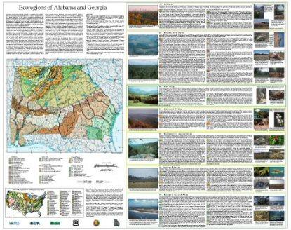
- Level IV Ecoregions of Alabama and Georgia--poster front side 46" X 36" (6.2 mb)
- Level IV Ecoregions of Alabama and Georgia--poster back side 46" X 36" (240 kb)
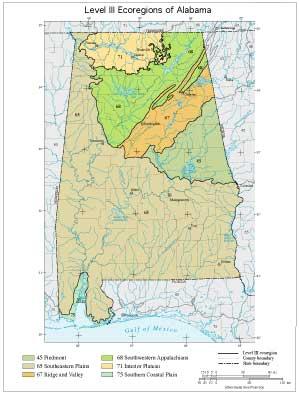
- Level III Ecoregions of Alabama--page size (584 kb)
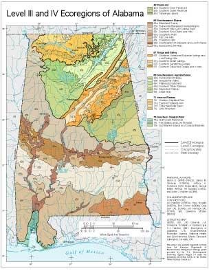
- Level III and IV Ecoregions of Alabama--page size (604 kb)
Ecoregion Descriptions (MSWord documents)
- Alabama descriptions (44 kb)
- Alabama and Georgia tabular descriptions (116 kb)
- Alabama tabular descriptions (84 kb)
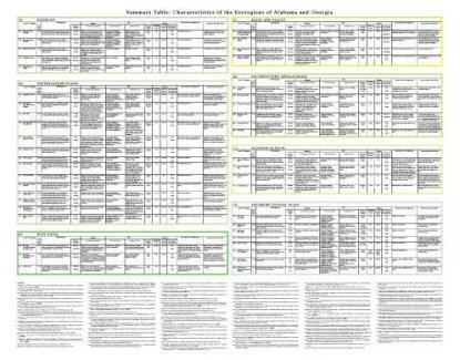
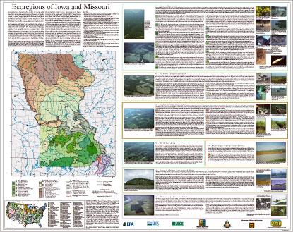
Ecoregions denote areas of general similarity in ecosystems and in the type, quality, and quantity of environmental resources. They are designed to serve as a spatial framework for the research, assessment, management, and monitoring of ecosystems and ecosystem components. Ecoregions are directly applicable to the immediate needs of state agencies, including the development of biological criteria and water quality standards and the establishment of management goals for nonpoint-source pollution. They are also relevant to integrated ecosystem management, an ultimate goal of many federal and state resource management agencies.
The approach used to compile this map is based on the premise that ecological regions can be identified through the analysis of the spatial patterns and the composition of biotic and abiotic phenomena that affect or reflect differences in ecosystem quality and integrity (Wiken 1986; Omernik 1987, 1995). These phenomena include geology, physiography, vegetation, climate, soils, land use, wildlife, and hydrology. The relative importance of each characteristic varies from one ecological region to another regardless of the hierarchical level. A Roman numeral hierarchical scheme has been adopted for different levels of ecological regions. Level I is the coarsest level, dividing North America into 15 ecological regions. Level II divides the continent into 52 regions (Commission for Environmental Cooperation Working Group 1997). At level III, the continental United States contains 104 ecoregions and the conterminous United States has 84 ecoregions (United States Environmental Protection Agency [USEPA] 2000). Level IV is a further subdivision of level III ecoregions. Explanations of the methods used to define the USEPA’s ecoregions are given in Omernik (1995), Omernik and others (2000), Griffith and others (1994), and Gallant and others (1989).
Alabama and Georgia contain barrier islands and coastal lowlands, large river floodplain forests, rolling plains and plateaus, forested mountains, and a variety of aquatic habitats. Ecological and biological diversity is enormous. There are 7 level III ecoregions and 44 level IV ecoregions in Alabama and Georgia and most continue into ecologically similar parts of adjacent states.
The level III and IV ecoregion map on this poster was compiled at a scale of 1:250,000 and depicts revisions and subdivisions of earlier level III ecoregions that were originally compiled at a smaller scale (USEPA 2000; Omernik 1987). This poster is part of a collaborative project primarily between USEPA Region IV, USEPA National Health and Environmental Effects Research Laboratory (Corvallis, Oregon), Alabama Department of Environmental Management (ADEM), Georgia Department of Natural Resources (GA DNR), and the United States Department of Agriculture-Natural Resources Conservation Service (NRCS). Collaboration and consultation also occurred with the United States Department of Agriculture-Forest Service (USFS), United States Department of the Interior-Geological Survey (USGS)-Earth Resources Observation Systems (EROS) Data Center, and with other State of Alabama and State of Georgia agencies.
The project is associated with an interagency effort to develop a common framework of ecological regions. Reaching that objective requires recognition of the differences in the conceptual approaches and mapping methodologies applied to develop the most common ecoregion-type frameworks, including those developed by the USFS (Bailey and others, 1994), the USEPA (Omernik 1987, 1995), and the NRCS (U.S. Department of Agriculture-Soil Conservation Service, 1981). As each of these frameworks is further refined, their differences are becoming less discernible. Regional collaborative projects such as this one in Alabama and Georgia, where some agreement has been reached among multiple resource management agencies, is a step toward attaining consensus and consistency in ecoregion frameworks for the entire nation.
Literature Cited:
Bailey, R.G., Avers, P.E., King, T., and McNab, W.H., eds., 1994, Ecoregions and subregions of the United States (map) (supplementary table of map unit descriptions compiled and edited by McNab, W.H. and Bailey, R.G.): Washington, D.C., U.S. Department of Agriculture-Forest Service, scale 1:7,500,000.
Commission for Environmental Cooperation Working Group, 1997, Ecological regions of North America - toward a common perspective: Montreal, Quebec, Commission for Environmental Cooperation, 71 p.
Gallant, A.L., Whittier, T.R., Larsen, D.P., Omernik, J.M., and Hughes, R.M., 1989, Regionalization as a tool for managing environmental resources: Corvallis, Oregon, U.S. Environmental Protection Agency, EPA/600/3-89/060, 152 p.
Griffith, G.E., Omernik, J.M., Wilton, T.F., and Pierson, S.M., 1994, Ecoregions and subregions of Iowa - a framework for water quality assessment and management: The Journal of the Iowa Academy of Science, v. 101, no. 1, p. 5-13.
Omernik, J.M., 1987, Ecoregions of the conterminous United States (map supplement): Annals of the Association of American Geographers, v. 77, no. 1, p. 118-125, scale 1:7,500,000.
Omernik, J.M., 1995, Ecoregions - a framework for environmental management, in Davis, W.S. and Simon, T.P., eds., Biological assessment and criteria-tools for water resource planning and decision making: Boca Raton, Florida, Lewis Publishers, p. 49-62.
Omernik, J.M., Chapman, S.S., Lillie, R.A., and Dumke, R.T., 2000, Ecoregions of Wisconsin: Transactions of the Wisconsin Academy of Sciences, Arts and Letters, v. 88, no. 2000, p. 77-103.
U.S. Department of Agriculture-Soil Conservation Service, 1981, Land resource regions and major land resource areas of the United States: Agriculture Handbook 296, 156 p.
U.S. Environmental Protection Agency, 2000, Level III ecoregions of the continental United States (revision of Omernik, 1987): Corvallis, Oregon, U.S. Environmental Protection Agency-National Health and Environmental Effects Research Laboratory, Map M-1, various scales.
Wiken, E., 1986, Terrestrial ecozones of Canada: Ottawa, Environment Canada, Ecological Land Classification Series no. 19, 26 p.
PRINCIPAL AUTHORS: Glenn E. Griffith (NRCS), James M. Omernik (USEPA), Jeffrey A. Comstock (OAO Corporation), Steve Lawrence (NRCS), George Martin (NRCS), Art Goddard (USFS), Vickie J. Hulcher (ADEM), and Trish Foster (GA DNR).
COLLABORATORS AND CONTRIBUTORS: Hoke Howard (USEPA), Jim Harrison (USEPA), Greg Lein (Alabama Department of Conservation and Natural Resources [AL DCNR]), Bruce Pruitt (USEPA), Patti Lanford (GA DNR), Bob Cooner (ADEM), Jon Hornsby (AL DCNR), Dave Melgaard (USEPA), Tom Loveland (USGS), Lawrence McGee (NRCS), Shannon Winsness (GA DNR), Bill Kennedy (GA DNR), Becky Blasius (GA DNR), Kristen Sanford (GA DNR), Dick Rightmyer (USFS), and Ron Stephens (USFS).
REVIEWERS: Burchard Carter (Georgia Southwestern State Univ.), Pat O'Neil (Geological Survey of AL), Cliff Webber (Auburn Univ.), and Larry West (Univ. of GA).
CITING THIS POSTER: Griffith, G.E., Omernik, J.M., Comstock, J.A., Lawrence, S., Martin, G., Goddard, A., Hulcher, V.J., and Foster, T., 2001, Ecoregions of Alabama and Georgia, (color poster with map, descriptive text, summary tables, and photographs): Reston, Virginia, U.S. Geological Survey (map scale 1:1,700,000).
This project was partially supported by funds from the Alabama Department of Environmental Management and the Georgia Department of Natural Resources through grants provided by the U.S. Environmental Protection Agency Region IV under the provisions of Section 319(h) of the Federal Water Pollution Control Act.
- Florida
Florida
GIS Data (shapefiles, metadata and symbology)
- Florida Level III Shapefile (3.2 mb)
- Florida Level III Metadata and Florida Level III Symbology
- Florida Level IV Shapefile (3.2 mb)
- Florida Level IV Metadata and Florida Level IV Symbology
- Instructions for applying symbology to ecoregions
Maps (available in PDF format)
- Level III and IV Ecoregions of Florida--16" X 18" (740 kb)
- Level III and IV Ecoregions of Florida--page size (824 kb)
Map Thumbnail 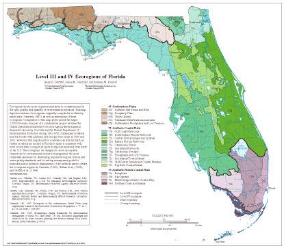 Level III and IV Ecoregions of Florida--16" X 18" (740 kb)
Ecoregions denote areas of general similarity in ecosystems and in the type, quality, and quantity of environmental resources. This map depicts revisions of ecoregions, originally compiled at a relatively small scale (Omernik, 1987), as well as subregions of those ecoregions. Compilation of this map, performed at the larger 1:250,000-scale, was part of a collaborative project between the United States Environmental Protection Agency Environmental Research Laboratory-Corvallis and the Florida Department of Environmental Protection during 1991-1993. Subsequent revisions near the border with Alabama and Georgia were made in 1999 and 2001. However, this map should be considered an interim draft, as further revisions are needed in Florida to make it consistent with more recent state ecoregion projects in adjacent areas and other parts of the U.S. The ecoregions are designed to serve as a spatial framework for environmental resource management: the most immediate needs are for developing regional biological criteria and water quality standards, and for setting management goals for nonpoint-source pollution. Explanation of the methods used to define the ecoregions is given in Omernik, (1995), Gallant et al., (1989), and Griffith et al., (1994).
Literature Cited:
Gallant, A.L., Whittier, T.R., Larsen, D.P., Omernik, J.M., and Hughes, R.M., 1989, Regionalization as a tool for managing environmental resources: Corvallis, Oregon, U.S. Environmental Protection Agency EPA/600/3-89/060, 152 p.
Griffith, G.E., Omernik, J.M., Rohm, C.W., and Pierson, S.M., 1994, Florida regionalization project: Corvallis, Oregon, U.S. Environmental Protection Agency, National Health and Environmental Effects Research Laboratory, EPA/600/Q-95/002, 83 p.
Omernik, J.M., 1987, Ecoregions of the conterminous United States (map supplement): Annals of the Association of American Geographers, v. 77, no. 1, p. 118-125, scale 1:7,500,000.
Omernik, J.M., 1995, Ecoregions-a spatial framework for environmental management, in Davis, W.S. and Simon, T.P., eds., Biological assessment and criteria-tools for water resource planning and decision making: Boca Raton, Florida, Lewis Publishers, p. 49-62.
Lake Regions of Florida
GIS Data (shapefiles, metadata and symbology)
Maps (available in PDF format)
- Lake Regions of Florida--poster front side 46" X 36" (5 mb)
- Lake Regions of Florida--poster back side 46" X 36" (2.1 mb)
Report
Map Thumbnails 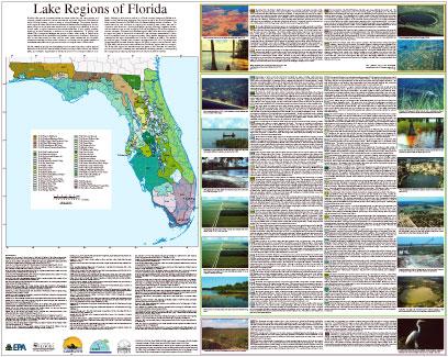 Lake Regions of Florida--poster front side 46" X 36" (5 mb)
 Lake Regions of Florida--poster back side 46" X 36" (2.1 mb)
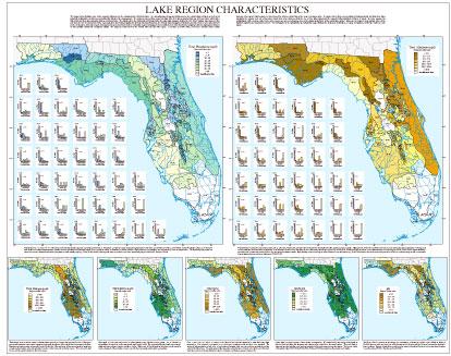
Florida's lakes provide important habitats for plants, birds, fish, and other animals, and comprise a valuable resource for human activities and enjoyment. More than 7,700 lakes are found in Florida, and they occur in a variety of ecological settings. The physical, chemical, and biological diversity of these lakes complicates lake assessment and management. In many states, it has been shown that water resources can be managed more effectively if they are viewed within a regional framework that reflects differences in their quality, quantity, hydrology, and their sensitivity or resilience to ecological disturbances. To develop cost-effective lake management strategies that protect or restore water quality in Florida lakes, regional differences in the capabilities and potentials of lakes must be considered. Hydrologic unit or basin frameworks are often used for water quality assessments and ecosystem management activities, but these units or basins do not correspond to the spatial patterns of characteristics that influence the physical, chemical, or biological nature of Florida lakes.
General patterns of geology and physiography have been used previously to explain regional differences in Florida lake water chemistry (Canfield and Hoyer 1988; Pollman and Canfield 1991), and ecosystem characteristics of Florida lakes have been summarized (Brenner et al. 1990). Building on this work, as well as on a Florida ecoregion framework (Griffith et al. 1994), we have defined these forty-seven lake regions as part of the Florida Department of Environmental Protection's (FL DEP) Lake Bioassessment/Regionalization Initiative. The spatial framework was developed by mapping and analyzing water quality data sets in conjunction with information on soils, physiography, geology, hydrology, vegetation, climate, and land use/land cover, as well as relying on the expert judgment of local limnologists and resource managers. This framework delineates regions within which there is homogeneity in the types and quality of lakes and their association with landscape characteristics, or where there is a particular mosaic of lake types and quality. More detailed descriptions of methods, materials, and lake region characteristics can be found in Griffith et al. (1997). The identifier for each lake region consists of two numbers: the first number (65, 75, or 76) relates to the United States Environmental Protection Agency (US EPA) ecoregion number (Omernik 1987; US EPA 1997), and the second number refers to the Florida lake regions within an ecoregion. The Florida lake regions and associated maps and graphs of lake chemistry are intended to provide a framework for assessing lake characteristics, calibrating predictive models, guiding lake management, and framing expectations by lake users and lakeshore residents.
PRINCIPAL AUTHORS: Glenn Griffith (US EPA), Daniel Canfield, Jr. (University of Florida), Christine Horsburgh (University of Florida), James Omernik (US EPA), Sandra Azevedo (OAO Corp.)
COLLABORATORS AND CONTRIBUTORS: Mark Hoyer, Eric Schulz, Roger Bachmann, and Sandy Fisher (University of Florida); James Hulbert, Michael Scheinkman, Ellen McCarron, and Russ Frydenborg (FL DEP); Craig Dye (Southwest Florida Water Management District); Alan Woods (Dynamac Corp.); Curtis Watkins (Florida Lake Management Society); citizen volunteers of Florida LAKEWATCH
- Georgia
GIS Data (shapefiles, metadata and symbology)
- Georgia Level III Shapefile (549 kb)
- Georgia Level III Metadata and Georgia Level III Symbology
- Georgia Level IV Shapefile (1.16 mb)
- Georgia Level IV Metadata and Georgia Level IV Symbology
- Instructions for applying symbology to ecoregions
Ecoregion Descriptions (MSWord documents)
Maps (available in PDF format)
- Level IV Ecoregions of Alabama and Georgia--poster front side 46" X 36" (6.2 mb)
- Level IV Ecoregions of Alabama and Georgia--poster back side 46" X 36" (240 kb)
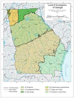
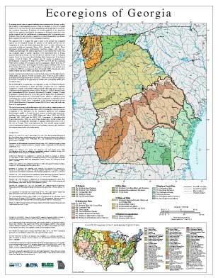
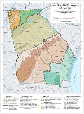
- Level III Ecoregions of Georgia--page size (660 kb)
- Level III and IV Ecoregions of Georgia--23" X 29" (1.2 mb)
- Level III and IV Ecoregions of Georgia--42" X 34" (1.4 mb)
Ecoregions denote areas of general similarity in ecosystems and in the type, quality, and quantity of environmental resources. They are designed to serve as a spatial framework for the research, assessment, management, and monitoring of ecosystems and ecosystem components. Ecoregions are directly applicable to the immediate needs of state agencies, including the development of biological criteria and water quality standards and the establishment of management goals for nonpoint-source pollution. They are also relevant to integrated ecosystem management, an ultimate goal of many federal and state resource management agencies.
The approach used to compile this map is based on the premise that ecological regions can be identified through the analysis of the spatial patterns and the composition of biotic and abiotic phenomena that affect or reflect differences in ecosystem quality and integrity (Wiken 1986; Omernik 1987, 1995). These phenomena include geology, physiography, vegetation, climate, soils, land use, wildlife, and hydrology. The relative importance of each characteristic varies from one ecological region to another regardless of the hierarchical level. A Roman numeral hierarchical scheme has been adopted for different levels of ecological regions. Level I is the coarsest level, dividing North America into 15 ecological regions. Level II divides the continent into 52 regions (Commission for Environmental Cooperation Working Group 1997). At level III, the continental United States contains 104 ecoregions and the conterminous United States has 84 ecoregions (United States Environmental Protection Agency [USEPA] 2000). Level IV is a further subdivision of level III ecoregions. Explanations of the methods used to define the USEPA’s ecoregions are given in Omernik (1995), Omernik and others (2000), Griffith and others (1994), and Gallant and others (1989).
Alabama and Georgia contain barrier islands and coastal lowlands, large river floodplain forests, rolling plains and plateaus, forested mountains, and a variety of aquatic habitats. Ecological and biological diversity is enormous. There are 7 level III ecoregions and 44 level IV ecoregions in Alabama and Georgia and most continue into ecologically similar parts of adjacent states.
The level III and IV ecoregion map on this poster was compiled at a scale of 1:250,000 and depicts revisions and subdivisions of earlier level III ecoregions that were originally compiled at a smaller scale (USEPA 2000; Omernik 1987). This poster is part of a collaborative project primarily between USEPA Region IV, USEPA National Health and Environmental Effects Research Laboratory (Corvallis, Oregon), Alabama Department of Environmental Management (ADEM), Georgia Department of Natural Resources (GA DNR), and the United States Department of Agriculture-Natural Resources Conservation Service (NRCS). Collaboration and consultation also occurred with the United States Department of Agriculture-Forest Service (USFS), United States Department of the Interior-Geological Survey (USGS)-Earth Resources Observation Systems (EROS) Data Center, and with other State of Alabama and State of Georgia agencies.
The project is associated with an interagency effort to develop a common framework of ecological regions. Reaching that objective requires recognition of the differences in the conceptual approaches and mapping methodologies applied to develop the most common ecoregion-type frameworks, including those developed by the USFS (Bailey and others, 1994), the USEPA (Omernik 1987, 1995), and the NRCS (U.S. Department of Agriculture-Soil Conservation Service, 1981). As each of these frameworks is further refined, their differences are becoming less discernible. Regional collaborative projects such as this one in Alabama and Georgia, where some agreement has been reached among multiple resource management agencies, is a step toward attaining consensus and consistency in ecoregion frameworks for the entire nation.
Literature Cited:
Bailey, R.G., Avers, P.E., King, T., and McNab, W.H., eds., 1994, Ecoregions and subregions of the United States (map) (supplementary table of map unit descriptions compiled and edited by McNab, W.H. and Bailey, R.G.): Washington, D.C., U.S. Department of Agriculture-Forest Service, scale 1:7,500,000.
Commission for Environmental Cooperation Working Group, 1997, Ecological regions of North America - toward a common perspective: Montreal, Quebec, Commission for Environmental Cooperation, 71 p.
Gallant, A.L., Whittier, T.R., Larsen, D.P., Omernik, J.M., and Hughes, R.M., 1989, Regionalization as a tool for managing environmental resources: Corvallis, Oregon, U.S. Environmental Protection Agency, EPA/600/3-89/060, 152 p.
Griffith, G.E., Omernik, J.M., Wilton, T.F., and Pierson, S.M., 1994, Ecoregions and subregions of Iowa - a framework for water quality assessment and management: The Journal of the Iowa Academy of Science, v. 101, no. 1, p. 5-13.
Omernik, J.M., 1987, Ecoregions of the conterminous United States (map supplement): Annals of the Association of American Geographers, v. 77, no. 1, p. 118-125, scale 1:7,500,000.
Omernik, J.M., 1995, Ecoregions - a framework for environmental management, in Davis, W.S. and Simon, T.P., eds., Biological assessment and criteria-tools for water resource planning and decision making: Boca Raton, Florida, Lewis Publishers, p. 49-62.
Omernik, J.M., Chapman, S.S., Lillie, R.A., and Dumke, R.T., 2000, Ecoregions of Wisconsin: Transactions of the Wisconsin Academy of Sciences, Arts and Letters, v. 88, no. 2000, p. 77-103.
U.S. Department of Agriculture-Soil Conservation Service, 1981, Land resource regions and major land resource areas of the United States: Agriculture Handbook 296, 156 p.
U.S. Environmental Protection Agency, 2000, Level III ecoregions of the continental United States (revision of Omernik, 1987): Corvallis, Oregon, U.S. Environmental Protection Agency-National Health and Environmental Effects Research Laboratory, Map M-1, various scales.
Wiken, E., 1986, Terrestrial ecozones of Canada: Ottawa, Environment Canada, Ecological Land Classification Series no. 19, 26 p.
PRINCIPAL AUTHORS: Glenn E. Griffith (NRCS), James M. Omernik (USEPA), Jeffrey A. Comstock (OAO Corporation), Steve Lawrence (NRCS), George Martin (NRCS), Art Goddard (USFS), Vickie J. Hulcher (ADEM), and Trish Foster (GA DNR).
COLLABORATORS AND CONTRIBUTORS: Hoke Howard (USEPA), Jim Harrison (USEPA), Greg Lein (Alabama Department of Conservation and Natural Resources [AL DCNR]), Bruce Pruitt (USEPA), Patti Lanford (GA DNR), Bob Cooner (ADEM), Jon Hornsby (AL DCNR), Dave Melgaard (USEPA), Tom Loveland (USGS), Lawrence McGee (NRCS), Shannon Winsness (GA DNR), Bill Kennedy (GA DNR), Becky Blasius (GA DNR), Kristen Sanford (GA DNR), Dick Rightmyer (USFS), and Ron Stephens (USFS).
REVIEWERS: Burchard Carter (Georgia Southwestern State Univ.), Pat O'Neil (Geological Survey of AL), Cliff Webber (Auburn Univ.), and Larry West (Univ. of GA).
CITING THIS POSTER: Griffith, G.E., Omernik, J.M., Comstock, J.A., Lawrence, S., Martin, G., Goddard, A., Hulcher, V.J., and Foster, T., 2001, Ecoregions of Alabama and Georgia, (color poster with map, descriptive text, summary tables, and photographs): Reston, Virginia, U.S. Geological Survey (map scale 1:1,700,000).
This project was partially supported by funds from the Alabama Department of Environmental Management and the Georgia Department of Natural Resources through grants provided by the U.S. Environmental Protection Agency Region IV under the provisions of Section 319(h) of the Federal Water Pollution Control Act .
- Kentucky
GIS Data (shapefiles, metadata and symbology)
- Kentucky Level III Shapefile (368 kb)
- Kentucky Level III Metadata and Kentucky Level III Symbology
- Kentucky Level IV Shapefile (367 kb)
- Kentucky Level IV Metadata and Kentucky Level IV Symbology
- Instructions for applying symbology to ecoregions
Maps (available in PDF format)
- Level IV Ecoregions of Kentucky--poster front side 46" X 36" (7.1 mb)
- Level IV Ecoregions of Kentucky--poster back side 46" X 36" (468 mb)
- Level III and IV Ecoregions of Kentucky--30" X 24" (1.4 mb)
- Level III and IV Ecoregions of Kentucky--page size (1.8 mb)
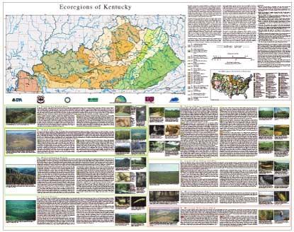
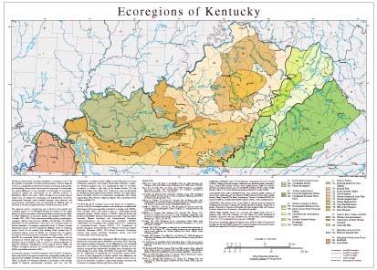
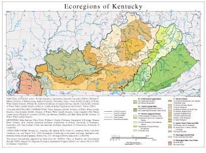
Ecoregions denote areas of general similarity in ecosystems and in the type, quality, and quantity of environmental resources. They are designed to serve as a spatial framework for the research, assessment, management, and monitoring of ecosystems and ecosystem components. By recognizing the spatial differences in the capacities and potentials of ecosystems, ecoregions stratify the environment by its probable response to disturbance (Bryce and others, 1999). Ecoregions are general purpose regions that are critical for structuring and implementing ecosystem management strategies across federal agencies, state agencies, and nongovernment organizations that are responsible for different types of resources in the same geographical areas (Omernik and others, 2000).
The approach used to compile this map is based on the premise that ecological regions can be identified through the analysis of the spatial patterns and the composition of biotic and abiotic phenomena that affect or reflect differences in ecosystem quality and integrity (Wiken, 1986; Omernik, 1987, 1995). These phenomena include geology, physiography, vegetation, climate, soils, land use, wildlife, and hydrology. The relative importance of each phenomenon varies from one ecological region to another regardless of ecoregion hierarchical level. A Roman numeral hierarchical scheme has been adopted for different levels of ecological regions. Level I is the coarsest level, dividing North America into 15 ecological regions. Level II divides the continent into 52 regions (Commission for Environmental Cooperation Working Group, 1997). At level III, the continental United States contains 104 ecoregions and the conterminous United States has 84 ecoregions (U.S. Environmental Protection Agency [USEPA], 2002). Level IV is a further subdivision of level III ecoregions. Explanations of the methods used to define the USEPA’s ecoregions are given in Omernik (1995), Omernik and others (2000), and Gallant and others (1989).
In Kentucky, there are 7 level III ecoregions and 25 level IV ecoregions; all but four level IV ecoregions continue into ecologically similar parts of adjacent states (Griffith, Omernik, and Azevedo, 1998; Woods and others, 1998). Ecological and biological diversity in Kentucky is very strongly related to regional physiographic, geologic, land use, and soil characteristics. Deciduous forests widely covered Kentucky at the time of European settlement. About half is still forested. Extensive "barrens" (i.e. bluestem prairies) were once maintained by fires set by Native Americans on rolling to flat parts of the Interior Plateau (71) and Mississippi Valley Loess Plains (74). Today, these areas are dominated by cropland and pastureland and the historic "barrens" are nearly extinct. Major coal fields occur in the Southwestern Appalachians (68), Central Appalachians (69), Western Allegheny Plateau (70), and Interior River Valleys and Hills (72).
The level III and IV ecoregion map on this poster was compiled at a scale of 1:250,000 and depicts revisions and subdivisions of earlier level III ecoregions that were originally compiled at a smaller scale (USEPA, 2002; Omernik, 1987). This poster is part of a collaborative project primarily between USEPA Region 4, USEPA National Health and Environmental Effects Research Laboratory (Corvallis, Oregon), and the Kentucky Natural Resources and Environmental Protection Cabinet–Department for Environmental Protection (KDEP). Collaboration and consultation also occurred with the U.S. Department of Agriculture–Forest Service (USFS), U.S. Department of Interior–Geological Survey (USGS), The Nature Conservancy, Eastern Kentucky University (EKU), USGS–Earth Resources Observation Systems Data Center, Kentucky Geological Survey, and other Commonwealth of Kentucky agencies.
The project is associated with an interagency effort to develop a common framework of ecological regions (McMahon and others, 2001). Reaching that objective requires recognition of the differences in the conceptual approaches and mapping methodologies applied to develop the most common ecoregion-type frameworks, including those developed by the USFS (Bailey and others, 1994), the USEPA (Omernik 1987, 1995), and the U.S. Department of Agriculture–Soil Conservation Service (1981). As each of these frameworks is further refined, their differences are becoming less discernible. Each collaborative ecoregion project, such as this one in Kentucky, comprises a step toward attaining consensus and consistency in ecoregion frameworks for the entire nation.
Literature Cited:
Bailey, R.G., Avers, P.E., King, T., and McNab, W.H., eds., 1994, Ecoregions and subregions of the United States (map): Washington, D.C., USFS, scale 1:7,500,000.
Bryce, S.A., Omernik, J.M., and Larsen, D.P., 1999, Ecoregions—a geographic framework to guide risk characterization and ecosystem management: Environmental Practice, v. 1, no. 3, p. 141-155.
Commission for Environmental Cooperation Working Group, 1997, Ecological regions of North America—toward a common perspective: Montreal, Commission for Environmental Cooperation, 71 p.
Gallant, A.L., Whittier, T.R., Larsen, D.P., Omernik, J.M., and Hughes, R.M., 1989, Regionalization as a tool for managing environmental resources: Corvallis, Oregon, U.S. Environmental Protection Agency, EPA/600/3-89/060, 152 p.
Griffith, G., Omernik, J., Azevedo, S., 1998, Ecoregions of Tennessee (text, map, summary tables, and photographs): Reston, Virginia, U.S. Geological Survey, map scale 1:940,000.
McMahon, G., Gregonis, S.M., Waltman, S.W., Omernik, J.M., Thorson, T.D., Freeouf, J.A., Rorick, A.H., and Keys, J.E., 2001, Developing a spatial framework of common ecological regions for the conterminous United States: Environmental Management, v. 28, no. 3, p. 293-316.
Omernik, J.M., 1987, Ecoregions of the conterminous United States (map supplement): Annals of the Association of American Geographers, v. 77, p. 118-125, scale 1:7,500,000.
Omernik, J.M., 1995, Ecoregions—a framework for environmental management, in Davis, W.S. and Simon, T.P., editors, Biological assessment and criteria-tools for water resource planning and decision making: Boca Raton, Florida, Lewis Publishers, p. 49-62.
Omernik, J.M., Chapman, S.S., Lillie, R.A., and Dumke, R.T., 2000, Ecoregions of Wisconsin: Transactions of the Wisconsin Academy of Sciences, Arts, and Letters, v. 88, p. 77-103.
U.S. Department of Agriculture–Soil Conservation Service, 198, Land resource regions and major land resource areas of the United States: Agriculture Handbook 296, 156 p.
U.S. Environmental Protection Agency, 2002, Level III ecoregions of the continental United States (revision of Omernik, 1987): Corvallis, Oregon, USEPA–National Health and Environmental Effects Research Laboratory, Map M-1, various scales.
Wiken, E., 1986, Terrestrial ecozones of Canada: Ottawa, Environment Canada, Ecological Land Classification Series no. 19, 26 p.
Woods, A.J., Omernik, J.M., Brockman, C.S., Gerber, T.D., Hosteter, W.D., and Azevedo, S.H., 1998, Ecoregions of Indiana and Ohio: Reston, USGS, map scale 1:500,000.
PRINCIPAL AUTHORS: Alan J. Woods (Dynamac Corporation), James M. Omernik (USEPA), William H. Martin (Division of Natural Areas, Eastern Kentucky University), Greg J. Pond (KDEP, Division of Water, Water Quality Branch), William M. Andrews (Kentucky Geological Survey), Sam M. Call (KDEP, Division of Water, Water Quality Branch), Jeffrey A. Comstock (Indus Corporation), and David D. Taylor (USFS).
COLLABORATORS AND CONTRIBUTORS: Terry Anderson (KDEP, Division of Water, Water Quality Branch), John Brumley (KDEP, Division of Water, Water Quality Branch), Julian Campbell (The Nature Conservancy), Thomas R. Loveland (USGS), Jim Harrison (USEPA), and Mike Mills (KDEP, Division of Water, Water Quality Branch).
REVIEWERS: Mike Barbour (Tetra Tech), William S. Bryant (Professor, Department of Biology, Thomas More College), H.R. DeSelm (Emeritus Professor, Department of Botany, University of Tennessee, Knoxville), and Clara Leuthart (Chair and Associate Professor, Department of Geosciences, University of Louisville).
CITING THIS POSTER: Woods, A.J., Omernik, J.M., Martin, W.H., Pond, G.J., Andrews, W.M., Call, S.M, Comstock, J.A., and Taylor, D.D., 2002, Ecoregions of Kentucky (color poster with map, descriptive text, summary tables, and photographs): Reston, VA., U.S. Geological Survey (map scale 1:1,000,000).
This project was partially supported by funds from the USEPA's Office of Research and Development through USEPA Region IV's Regional Ecological Assessment Program (REAP) via contract 68-D-01-0005 to Dynamac Corporation.
- Mississippi
Mississippi
GIS Data (shapefiles, metadata and symbology)
- Mississippi Level III Shapefile (267 kb)
- Mississippi Level III Metadata and Mississippi Level III Symbology
- Mississippi Level IV Shapefile (580 kb)
- Mississippi Level IV Metadata and Mississippi Level IV Symbology
- Instructions for applying symbology to ecoregions
Maps (available in PDF format)
- Level IV Ecoregions of Mississippi--poster front side 46" X 36" (15 mb)
- Level IV Ecoregions of Mississippi--poster back side 46" X 36" (704 kb)
- Level III and IV Ecoregions of Mississippi--24" X 26" (360 kb)
- Level III and IV Ecoregions of Mississippi--page size (364 kb)
Ecoregions denote areas of general similarity in ecosystems and in the type, quality, and quantity of environmental resources. They are designed to serve as a spatial framework for the research, assessment, management, and monitoring of ecosystems and ecosystem components. By recognizing the spatial differences in the capacities and potentials of ecosystems, ecoregions stratify the environment by its probable response to disturbance (Bryce and others, 1999). These general purpose regions are critical for structuring and implementing ecosystem management strategies across federal agencies, state agencies, and nongovernment organizations that are responsible for different types of resources within the same geographical areas (Omernik and others, 2000).
The approach used to compile this map is based on the premise that ecological regions are hierarchical and can be identified through the analysis of the spatial patterns and the composition of biotic and abiotic phenomena that affect or reflect differences in ecosystem quality and integrity (Wiken 1986; Omernik 1987, 1995). These phenomena include geology, physiography, vegetation, climate, soils, land use, wildlife, and hydrology. The relative importance of each characteristic varies from one ecological region to another regardless of the hierarchical level. A Roman numeral hierarchical scheme has been adopted for different levels of ecological regions. Level I is the coarsest level, dividing North America into 15 ecological regions. Level II divides the continent into 52 regions (Commission for Environmental Cooperation Working Group 1997). At level III, the continental United States contains 104 ecoregions and the conterminous United States has 84 ecoregions (United States Environmental Protection Agency [USEPA] 2003). Level IV is a further subdivision of level III ecoregions. Explanations of the methods used to define the USEPA’s ecoregions are given in Omernik (1995), Omernik and others (2000), and Gallant and others (1989).
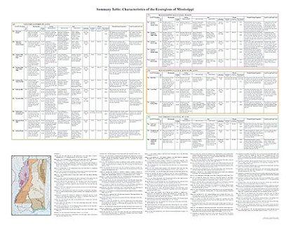
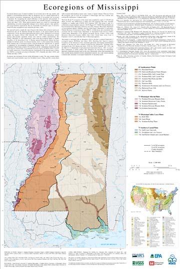
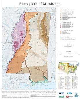
Ecological and biological diversity within Mississippi is great. The state contains barrier islands and coastal lowlands, large river floodplain forests, rolling and hilly coastal plains with evergreen and deciduous forests, and a variety of aquatic habitats. There are 4 level III ecoregions and 21 level IV ecoregions in Mississippi and most continue into ecologically similar parts of adjacent states.
The level III and IV ecoregions on this poster were compiled at a scale of 1:250,000 and depict revisions and subdivisions of earlier level III ecoregions that were originally compiled at a smaller scale (USEPA 2003; Omernik 1987). This poster is part of a collaborative project primarily between USEPA Region IV, USEPA National Health and Environmental Effects Research Laboratory (Corvallis, Oregon), Mississippi Department of Environmental Quality (MDEQ), and the United States Department of Agriculture-Natural Resources Conservation Service (NRCS). Collaboration and consultation also occurred with the United States Department of Agriculture-Forest Service (USFS), United States Department of the Interior-Geological Survey (USGS), USGS Earth Resources Observation Systems (EROS) Data Center, United States Army Corps of Engineers (USACE), and with other State of Mississippi agencies.
The project is associated with an interagency effort to develop a common framework of ecological regions (McMahon and others, 2001). Reaching that objective requires recognition of the differences in the conceptual approaches and mapping methodologies applied to develop the most common ecoregion-type frameworks, including those developed by the USFS (Bailey and others, 1994), the USEPA (Omernik 1987, 1995), and the NRCS (U.S. Department of Agriculture-Soil Conservation Service, 1981). As each of these frameworks is further refined, their differences are becoming less discernible. Regional collaborative projects such as this one in Mississippi, where some agreement has been reached among multiple resource management agencies, are a step toward attaining consensus and consistency in ecoregion frameworks for the entire nation.
Literature Cited:
Bailey, R.G., Avers, P.E., King, T., and McNab, W.H., eds., 1994, Ecoregions and subregions of the United States (map) (supplementary table of map unit descriptions compiled and edited by McNab, W.H. and Bailey, R.G.): Washington, D.C., U.S. Department of Agriculture-Forest Service, scale 1:7,500,000.
Bryce, S.A., Omernik, J.M., and Larsen, D.P., 1999, Ecoregions - a geographic framework to guide risk characterization and ecosystem management: Environmental Practice, v. 1, no. 3, p. 141-155.
Commission for Environmental Cooperation Working Group, 1997, Ecological regions of North America - toward a common perspective: Montreal, Quebec, Commission for Environmental Cooperation, 71 p.
Gallant, A.L., Whittier, T.R., Larsen, D.P., Omernik, J.M., and Hughes, R.M., 1989, Regionalization as a tool for managing environmental resources: Corvallis, Oregon, U.S. Environmental Protection Agency, EPA/600/3-89/060, 152 p.
McMahon, G., Gregonis, S.M., Waltman, S.W., Omernik, J.M., Thorson, T.D., Freeouf, J.A., Rorick, A.H., and Keys, J.E., 2001, Developing a spatial framework of common ecological regions for the conterminous United States: Environmental Management, v. 28, no. 3, p. 293-316.
Omernik, J.M., 1987, Ecoregions of the conterminous United States (map supplement): Annals of the Association of American Geographers, v. 77, no. 1, p. 118-125, scale 1:7,500,000.
Omernik, J.M., 1995, Ecoregions - a spatial framework for environmental management, in Davis, W.S., and Simon, T.P., eds., Biological assessment and criteria-tools for water resource planning and decision making: Boca Raton, Florida, Lewis Publishers, p. 49-62.
Omernik, J.M., Chapman, S.S., Lillie, R.A., and Dumke, R.T., 2000, Ecoregions of Wisconsin: Transactions of the Wisconsin Academy of Sciences, Arts and Letters, v. 88, no. 2000, p. 77-103.
U.S. Department of Agriculture-Soil Conservation Service, 1981, Land resource regions and major land resource areas of the United States: Agriculture Handbook 296, 156 p.
U.S. Environmental Protection Agency, 2003, Level III ecoregions of the continental United States (revision of Omernik, 1987): Corvallis, Oregon, U.S. Environmental Protection Agency-National Health and Environmental Effects Research Laboratory, Map M-1, various scales.
Wiken, E., 1986, Terrestrial ecozones of Canada: Ottawa, Environment Canada, Ecological Land Classification Series no. 19, 26 p.
PRINCIPAL AUTHORS: Shannen S. Chapman (Dynamac Corporation), Glenn E. Griffith (Dynamac Corporation), James M. Omernik (USEPA, retired), Jeffrey A. Comstock (Indus Corporation), Michael C. Beiser (MS DEQ), and Delaney Johnson (NRCS).
COLLABORATORS AND CONTRIBUTORS: Jim Harrison (USEPA), Mike Lilly (NRCS), Mike Bograd (MS DEQ), Larry Handley (USGS), Barb Kleiss (USACE), Alice Dossett (MS DEQ), Katherine Williams (MS DEQ), Chip Bray (MS DEQ), and Tom Loveland (USGS).
REVIEWERS: David Beckett (University of Southern Mississippi), J. Stephen Brewer (University of Mississippi), David Dockery (MS DEQ), Jerry Griffith, (University of Southern Mississippi), George Martin (NRCS), Robert Wales (University of Southern Mississippi), and Ron Wieland (Mississippi Natural Science Museum).
CITING THIS POSTER: Chapman, S.S, Griffith, G.E., Omernik, J.M., Comstock, J.A., Beiser, M.C., and Johnson, D., 2004, Ecoregions of Mississippi, (color poster with map, descriptive text, summary tables, and photographs): Reston, Virginia, U.S. Geological Survey (map scale 1:1,000,000).
This project was partially supported by funds from the Mississippi Department of Environmental Quality through grants provided by the U.S. Environmental Protection Agency Region IV under the provisions of Section 319(h) of the Federal Water Pollution Control Act.
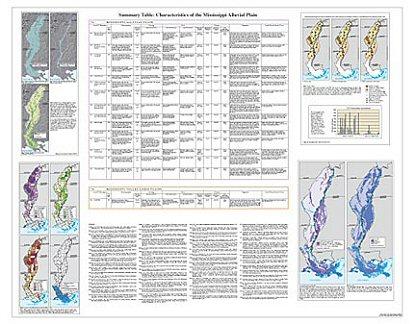
Mississippi Alluvial Plain
GIS Data (shapefiles, metadata and symbology)
- Mississippi Alluvial Plain Level III Shapefile (368 kb)
- Mississippi Alluvial Plain Level III Metadata
- Mississippi Alluvial Plain Level IV Shapefile (367 kb)
- Mississippi Alluvial Plain Level IV Metadata
Maps (available in PDF format)
- Level IV Ecoregions of the Mississippi Alluvial Plain--poster front side 45" X 35.5" (14 mb)
- Level IV Ecoregions of the Mississippi Alluvial Plain--poster back side 46" X 36" (2.6 mb)
- Level III and IV Ecoregions of the Mississippi Alluvial Plain--22" X 37" (560 kb)
- Level III and IV Ecoregions of the Mississippi Alluvial Plain--page size (600 kb)
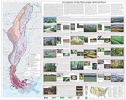
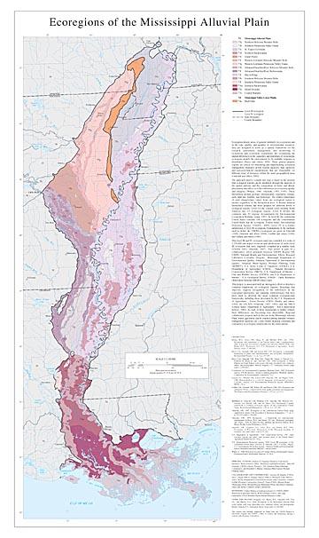
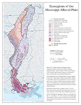
Ecoregions denote areas of general similarity in ecosystems and in the type, quality, and quantity of environmental resources; they are designed to serve as a spatial framework for the research, assessment, management, and monitoring of ecosystems and ecosystem components. By recognizing the spatial differences in the capacities and potentials of ecosystems, ecoregions stratify the environment by its probable response to disturbance (Bryce and others, 1999). These general purpose regions are critical for structuring and implementing ecosystem management strategies across federal agencies, state agencies, and non-government organizations that are responsible for different types of resources within the same geographical areas (Omernik and others, 2000).
The approach used to compile this map is based on the premise that ecological regions can be identified through the analysis of the spatial patterns and the composition of biotic and abiotic phenomena that affect or reflect differences in ecosystem quality and integrity (Wiken, 1986; Omernik, 1987, 1995). These phenomena include geology, physiography, vegetation, climate, soils, land use, wildlife, and hydrology. The relative importance of each characteristic varies from one ecological region to another regardless of the hierarchical level. A Roman numeral hierarchical scheme has been adopted for different levels of ecological regions. Level I is the coarsest level, dividing North America into 15 ecological regions. Level II divides the continent into 52 regions (Commission for Environmental Cooperation Working Group, 1997). At level III, the continental United States contains 104 ecoregions and the conterminous United States has 84 ecoregions (United States Environmental Protection Agency [USEPA], 2003). Level IV is a further subdivision of level III ecoregions. Explanations of the methods used to define the USEPA’s ecoregions are given in Omernik (1995), Omernik and others (2000), Griffith and others (1994), and Gallant and others (1989).
This level III and IV ecoregion map was compiled at a scale of 1:250,000 and depicts revisions and subdivisions of earlier level III ecoregions that were originally compiled at a smaller scale (USEPA 2003, Omernik, 1987). This poster is part of a collaborative effort primarily between USEPA Region VII, USEPA National Health and Environmental Effects Research Laboratory (Corvallis, Oregon), Mississippi Department of Environmental Quality, Arkansas Department of Environmental Quality, Arkansas Multi-Agency Wetland Planning Team (MAWPT), U.S. Army Corps of Engineers (USACE), U.S. Department of Agriculture (USDA) - Natural Resources Conservation Service (NRCS), U.S. Department of Interior - Fish and Wildlife Service (USFWS), and U.S. Department of Interior - U.S. Geological Survey (USGS) - Earth Resources Observation Systems (EROS) Data Center.
This project is associated with an interagency effort to develop a common framework of ecological regions. Reaching that objective requires recognition of the differences in the conceptual approaches and mapping methodologies that have been used to develop the most common ecoregion-type frameworks, including those developed by the U.S. Department of Agriculture - Forest Service (USFS) (Bailey and others, 1994), the US EPA (Omernik, 1987, 1995), and the NRCS (United States Department of Agriculture - Soil Conservation Service, 1981). As each of these frameworks is further refined, their differences are becoming less discernible. Regional collaborative projects such as this one in the Mississippi Alluvial Plain, where agreement can be reached among multiple resource management agencies, are a step toward attaining consensus and consistency in ecoregion frameworks for the entire nation.
Literature Cited:
Bailey, R.G., Avers, P.E., King, T., and McNab, W.H., eds., 1994, Ecoregions and subregions of the United States (map) (supplementary table of map unit descriptions compiled and edited by McNab, W.H., and Bailey, R.G.): Washington, D.C., U.S. Department of Agriculture - Forest Service, scale 1:7,500,000.
Bryce, S.A., Omernik, J.M., and Larsen, D.P., 1999, Ecoregions - a geographic framework to guide risk characterization and ecosystem management: Environmental Practice v. 1, no. 3, p. 141-155.
Bryce, S.A., Omernik, J.M., Pater, D.E., Ulmer, M., Schaar, J., Freeouf, J.A., Johnson, R., Kuck, P., and Azevedo, S.H., 1998, Ecoregions of North Dakota and South Dakota (color poster with map, descriptive text, summary tables, and photographs): Reston, Virginia, U.S. Geological Survey (map scale 1:1,500,000).
Commission for Environmental Cooperation Working Group, 1997, Ecological regions of North America - toward a common perspective: Montreal, Quebec, Commission for Environmental Cooperation, 71 p.
Gallant, A.L., Whittier, T.R., Larsen, D.P., Omernik, J.M., and Hughes, R.M., 1989, Regionalization as a tool for managing environmental resources: Corvallis, Oregon, U.S. Environmental Protection Agency, EPA/600/3-89/060, 152 p.
Griffith, G.E., Omernik, J.M., Wilton, T.F., and Pierson, S.M., 1994, Ecoregions and subregions of Iowa - a framework for water quality assessment and management: The Journal of the Iowa Academy of Science, v. 101, no. 1, p. 5-13.
McMahon, G., Gregonis, S.M., Waltman, S.W., Omernik, J.M., Thorson, T.D., Freeouf, J.A., Rorick, A.H., and J.E., Keys, 2001, Developing a spatial framework of common ecological regions for the conterminous United States, Environmental Management, v. 28, no. 3, p. 293-346.
Omernik, J.M., 1987, Ecoregions of the conterminous United States (map supplement): Annals of the Association of American Geographers, v. 77, no. 1, p. 118-125, scale 1:7,500,000.
Omernik, J.M., 1995, Ecoregions - a framework for environmental management, in Davis, W.S., and Simon, T.P., eds., Biological assessment and criteria - tools for water resource planning and decision making: Boca Raton, Florida, Lewis Publishers, p. 49-62.
Omernik, J.M., Chapman, S.S., Lillie, R.A., and Dumke, R.T., 2000, Ecoregions of Wisconsin: Transactions of the Wisconsin Academy of Sciences, Arts, and Letters, v. 88, p. 77-103.
U.S. Department of Agriculture - Soil Conservation Service, 1981, Land resource regions and major land resource areas of the United States: Agriculture Handbook 296, 156 p.
U.S. Environmental Protection Agency, 2003, Level III ecoregions of the continental United States (revision of Omernik, 1987): Corvallis, Oregon, U.S. Environmental Protection Agency - National Health and Environmental Effects Research Laboratory, Map M-1, various scales.
Wiken, E., 1986, Terrestrial ecozones of Canada: Ottawa, Environment Canada, Ecological Land Classification Series no. 19, 26 p.
PRINCIPAL AUTHORS: Shannen S. Chapman (Dynamac Corporation), Barbara A. Kleiss (USACE, ERDC -Waterways Experiment Station), James M. Omernik, (USEPA, retired), Thomas L. Foti (Arkansas Natural Heritage Commission), and Elizabeth O. Murray (Arkansas Multi-Agency Wetland Planning Team).
COLLABORATORS AND CONTRIBUTORS: Lawrence R. Handley (USGS), Jerry J. Daigle (NRCS), Delaney Johnson (NRCS), Michael E. Lilly (NRCS), Alan J. Woods (Department of Geosciences, Oregon State University), Glenn E. Griffith (Dynamac Corporation), Daniel J. Twedt (USGS), Michael Beiser (Mississippi DEQ), Michael Bograd (Mississippi DEQ), Ken Brazil (Arkansas DEQ), and Jeffrey Comstock (Indus Corporation).
REVIEWERS: Charles Klimas (consulting ecologist c/o USACE, ERDC-Waterways Experiment Station), Robert Delaney (USGS), and Leigh Fredrickson (USGS Northern Prairie Wildlife Research Center).
CITING THIS POSTER: Chapman, S.S., Kleiss, B.A., Omernik, J.M., Foti, T.L., and Murray, E.O., 2004, Ecoregions of the Mississippi Alluvial Plain (color poster with map, descriptive text, summary tables, and photographs): Reston, Virginia, U.S. Geological Survey (map scale 1:1,150,000).
This project was partially supported by funds from the USEPA Region 6, Biocriteria Program and USEPA - Office of Science and Technology through a contract with Dynamac Corporation.
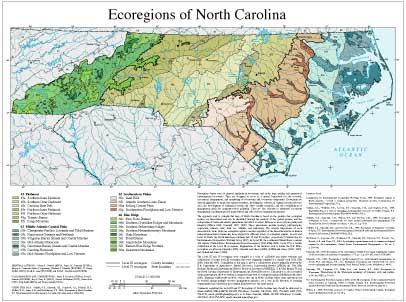
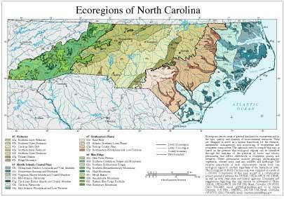
- North Carolina
GIS Data (shapefiles, metadata and symbology)
- North Carolina Level III Shapefile (1.25 mb)
- North Carolina Level III Metadata and North Carolina Level III Symbology
- North Carolina Level IV Shapefile (1.68 mb)
- North Carolina Level IV Metadata and North Carolina Level IV Symbology
Maps (available in PDF format)
- Level IV Ecoregions of North Carolina and South Carolina--poster front side 46" X 36" (8 mb)
- Level IV Ecoregions of North Carolina and South Carolina--poster back side 46" X 36" (56 kb)
- Level III and IV Ecoregions of North Carolina--24" X 19" (676 kb)
- Level III and IV Ecoregions of North Carolina--page size (680 kb)
Ecoregion Descriptions (MSWord documents)
- North Carolina descriptions (144 kb)
- North Carolina and South Carolina tabular descriptions (92 kb)
- North Carolina tabular descriptions (84 kb)
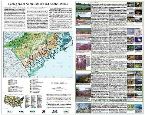
Ecoregions denote areas of general similarity in ecosystems and in the type, quality, and quantity of environmental resources. They are designed to serve as a spatial framework for the research, assessment, management, and monitoring of ecosystems and ecosystem components. By recognizing the spatial differences in the capacities and potentials of ecosystems, ecoregions stratify the environment by its probable response to disturbance (Bryce and others, 1999). These general purpose regions are critical for structuring and implementing ecosystem management strategies across federal agencies, state agencies, and nongovernment organizations that are responsible for different types of resources within the same geographical areas (Omernik and others, 2000).
The approach used to compile this map is based on the premise that ecological regions are hierarchical and can be identified through the analysis of the spatial patterns and the composition of biotic and abiotic phenomena that affect or reflect differences in ecosystem quality and integrity (Wiken 1986; Omernik 1987, 1995). These phenomena include geology, physiography, vegetation, climate, soils, land use, wildlife, and hydrology. The relative importance of each characteristic varies from one ecological region to another regardless of the hierarchical level. A Roman numeral hierarchical scheme has been adopted for different levels of ecological regions. Level I is the coarsest level, dividing North America into 15 ecological regions. Level II divides the continent into 52 regions (Commission for Environmental Cooperation Working Group 1997). At level III, the continental United States contains 104 ecoregions and the conterminous United States has 84 ecoregions (United States Environmental Protection Agency [USEPA] 2002). Level IV is a further subdivision of level III ecoregions. Explanations of the methods used to define the USEPA’s ecoregions are given in Omernik (1995), Omernik and others (2000), and Gallant and others (1989).
Ecological and biological diversity of the Carolinas is enormous. The two states contain barrier islands and coastal lowlands, large river floodplain forests, rolling plains and plateaus, forested mountains, and a variety of aquatic habitats. There are 5 level III ecoregions and 29 level IV ecoregions in North Carolina and South Carolina and most continue into ecologically similar parts of adjacent states.
The level III and IV ecoregions on this poster were compiled at a scale of 1:250,000 and depict revisions and subdivisions of earlier level III ecoregions that were originally compiled at a smaller scale (USEPA 2002; Omernik 1987). This poster is part of a collaborative project primarily between USEPA Region IV, USEPA National Health and Environmental Effects Research Laboratory (Corvallis, Oregon), North Carolina Department of Environment and Natural Resources (NCDENR), South Carolina Department of Health and Environmental Control (SCDHEC), and the United States Department of Agriculture-Natural Resources Conservation Service (NRCS). Collaboration and consultation also occurred with the United States Department of Agriculture-Forest Service (USFS), United States Department of the Interior-Geological Survey (USGS)-Earth Resources Observation Systems (EROS) Data Center, and with other State of North Carolina and State of South Carolina agencies.
The project is associated with an interagency effort to develop a common framework of ecological regions (McMahon and others, 2001). Reaching that objective requires recognition of the differences in the conceptual approaches and mapping methodologies applied to develop the most common ecoregion-type frameworks, including those developed by the USFS (Bailey and others, 1994), the USEPA (Omernik 1987, 1995), and the NRCS (U.S. Department of Agriculture-Soil Conservation Service, 1981). As each of these frameworks is further refined, their differences are becoming less discernible. Regional collaborative projects such as these in North Carolina and South Carolina, where some agreement has been reached among multiple resource management agencies, are a step toward attaining consensus and consistency in ecoregion frameworks for the entire nation.
Literature Cited:
Bailey, R.G., Avers, P.E., King, T., and McNab, W.H., eds., 1994, Ecoregions and subregions of the United States (map) (supplementary table of map unit descriptions compiled and edited by McNab, W.H. and Bailey, R.G.): Washington, D.C., U.S. Department of Agriculture-Forest Service, scale 1:7,500,000.
Bryce, S.A., Omernik, J.M., and Larsen, D.P., 1999, Ecoregions - a geographic framework to guide risk characterization and ecosystem management: Environmental Practice, v. 1, no. 3, p. 141-155.
Commission for Environmental Cooperation Working Group, 1997, Ecological regions of North America - toward a common perspective: Montreal, Quebec, Commission for Environmental Cooperation, 71 p.
Gallant, A.L., Whittier, T.R., Larsen, D.P., Omernik, J.M., and Hughes, R.M., 1989, Regionalization as a tool for managing environmental resources: Corvallis, Oregon, U.S. Environmental Protection Agency, EPA/600/3-89/060, 152 p.
McMahon, G., Gregonis, S.M., Waltman, S.W., Omernik, J.M., Thorson, T.D., Freeouf, J.A., Rorick, A.H., and Keys, J.E., 2001, Developing a spatial framework of common ecological regions for the conterminous United States: Environmental Management, v. 28, no. 3, p. 293-316.
Omernik, J.M., 1987, Ecoregions of the conterminous United States (map supplement): Annals of the Association of American Geographers, v. 77, no. 1, p. 118-125, scale 1:7,500,000.
Omernik, J.M., 1995, Ecoregions - a spatial framework for environmental management, in Davis, W.S., and Simon, T.P., eds., Biological assessment and criteria-tools for water resource planning and decision making: Boca Raton, Florida, Lewis Publishers, p. 49-62.
Omernik, J.M., Chapman, S.S., Lillie, R.A., and Dumke, R.T., 2000, Ecoregions of Wisconsin: Transactions of the Wisconsin Academy of Sciences, Arts and Letters, v. 88, no. 2000, p. 77-103.
U.S. Department of Agriculture-Soil Conservation Service, 1981, Land resource regions and major land resource areas of the United States: Agriculture Handbook 296, 156 p.
U.S. Environmental Protection Agency, 2002, Level III ecoregions of the continental United States (revision of Omernik, 1987): Corvallis, Oregon, U.S. Environmental Protection Agency-National Health and Environmental Effects Research Laboratory, Map M-1, various scales.
Wiken, E., 1986, Terrestrial ecozones of Canada: Ottawa, Environment Canada, Ecological Land Classification Series no. 19, 26 p.
PRINCIPAL AUTHORS: Glenn E. Griffith (NRCS), James M. Omernik (USEPA), Jeffrey A. Comstock (Indus Corporation), Michael P. Schafale (NCDENR), W. Henry McNab (USFS), David R. Lenat (NCDENR), Trish F. MacPherson (NCDENR), James B. Glover (SCDHEC), and Victor B. Shelburne (Clemson University).
COLLABORATORS AND CONTRIBUTORS: James E. Harrison (USEPA), David L. Penrose (NCDENR), Ronald C. Ahle (South Carolina Department of Natural Resources [SCDNR]), Roy L.Vick, Jr. (NRCS), Ben Stuckey, Jr. (NRCS), Dennis L. Law (USFS), Robert K. Peet (University of North Carolina), Richard T. Renfrow (SCDHEC), Paul G. Nystrom (SCDNR), Richard L. Scharf (SCDNR), Chip Smith (NRCS), Alan J. Woods (Dynamac Corporation), and Thomas R. Loveland (USGS).
REVIEWERS: Stanley W. Buol (North Carolina State University), Berman D. Hudson (NRCS), Charles F. Kovacik (University of South Carolina), Rudy E. Mancke (University of South Carolina), and Gerard McMahon (USGS).
CITING THIS POSTER: Griffith, G.E., Omernik, J.M., Comstock, J.A., Schafale, M.P., McNab, W.H., Lenat, D.R., MacPherson, T.F., Glover, J.B., and Shelburne, V.B., 2002, Ecoregions of North Carolina and South Carolina, (color poster with map, descriptive text, summary tables, and photographs): Reston, Virginia, U.S. Geological Survey (map scale 1:1,500,000).
This project was partially supported by funds from the North Carolina Department of Environment and Natural Resources and the South Carolina Department of Health and Environmental Control through grants provided by the U.S. Environmental Protection Agency Region IV under the provisions of Sections 104(b) and 319(h) of the Federal Water Pollution Control Act.
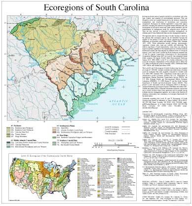
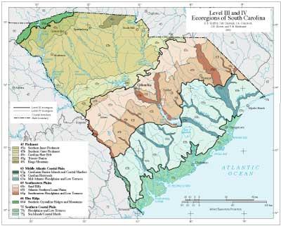
- South Carolina
GIS Data (shapefiles, metadata and symbology)
- South Carolina Level III Shapefile (506 kb)
- South Carolina Level III Metadata and South Carolina Level III Symbology
- South Carolina Level IV Shapefile (733 mb)
- South Carolina Level IV Metadata and South Carolina Level IV Symbology
- Instructions for applying symbology to ecoregions
Maps (available in PDF format)
- Level IV Ecoregions of North Carolina and South Carolina--poster front side 46" X 36" (8 mb)
- Level IV Ecoregions of North Carolina and South Carolina--poster back side 46" X 36" (56 kb)
- Level III and IV Ecoregions of South Carolina--22" X 19" (972 kb)
- Level III and IV Ecoregions of South Carolina--page size (380 kb)
Ecoregion Descriptions (MSWord documents)
- South Carolina descriptions (52 kb)
- North Carolina and South Carolina tabular descriptions (92 kb)
- South Carolina tabular descriptions (64 kb)
Ecoregions denote areas of general similarity in ecosystems and in the type, quality, and quantity of environmental resources. They are designed to serve as a spatial framework for the research, assessment, management, and monitoring of ecosystems and ecosystem components. By recognizing the spatial differences in the capacities and potentials of ecosystems, ecoregions stratify the environment by its probable response to disturbance (Bryce and others, 1999). These general purpose regions are critical for structuring and implementing ecosystem management strategies across federal agencies, state agencies, and nongovernment organizations that are responsible for different types of resources within the same geographical areas (Omernik and others, 2000).
The approach used to compile this map is based on the premise that ecological regions are hierarchical and can be identified through the analysis of the spatial patterns and the composition of biotic and abiotic phenomena that affect or reflect differences in ecosystem quality and integrity (Wiken 1986; Omernik 1987, 1995). These phenomena include geology, physiography, vegetation, climate, soils, land use, wildlife, and hydrology. The relative importance of each characteristic varies from one ecological region to another regardless of the hierarchical level. A Roman numeral hierarchical scheme has been adopted for different levels of ecological regions. Level I is the coarsest level, dividing North America into 15 ecological regions. Level II divides the continent into 52 regions (Commission for Environmental Cooperation Working Group 1997). At level III, the continental United States contains 104 ecoregions and the conterminous United States has 84 ecoregions (United States Environmental Protection Agency [USEPA] 2002). Level IV is a further subdivision of level III ecoregions. Explanations of the methods used to define the USEPA’s ecoregions are given in Omernik (1995), Omernik and others (2000), and Gallant and others (1989).
Ecological and biological diversity of the Carolinas is enormous. The two states contain barrier islands and coastal lowlands, large river floodplain forests, rolling plains and plateaus, forested mountains, and a variety of aquatic habitats. There are 5 level III ecoregions and 29 level IV ecoregions in North Carolina and South Carolina and most continue into ecologically similar parts of adjacent states.
The level III and IV ecoregions on this poster were compiled at a scale of 1:250,000 and depict revisions and subdivisions of earlier level III ecoregions that were originally compiled at a smaller scale (USEPA 2002; Omernik 1987). This poster is part of a collaborative project primarily between USEPA Region IV, USEPA National Health and Environmental Effects Research Laboratory (Corvallis, Oregon), North Carolina Department of Environment and Natural Resources (NCDENR), South Carolina Department of Health and Environmental Control (SCDHEC), and the United States Department of Agriculture-Natural Resources Conservation Service (NRCS). Collaboration and consultation also occurred with the United States Department of Agriculture-Forest Service (USFS), United States Department of the Interior-Geological Survey (USGS)-Earth Resources Observation Systems (EROS) Data Center, and with other State of North Carolina and State of South Carolina agencies.
The project is associated with an interagency effort to develop a common framework of ecological regions (McMahon and others, 2001). Reaching that objective requires recognition of the differences in the conceptual approaches and mapping methodologies applied to develop the most common ecoregion-type frameworks, including those developed by the USFS (Bailey and others, 1994), the USEPA (Omernik 1987, 1995), and the NRCS (U.S. Department of Agriculture-Soil Conservation Service, 1981). As each of these frameworks is further refined, their differences are becoming less discernible. Regional collaborative projects such as these in North Carolina and South Carolina, where some agreement has been reached among multiple resource management agencies, are a step toward attaining consensus and consistency in ecoregion frameworks for the entire nation.
Literature Cited:
Bailey, R.G., Avers, P.E., King, T., and McNab, W.H., eds., 1994, Ecoregions and subregions of the United States (map) (supplementary table of map unit descriptions compiled and edited by McNab, W.H. and Bailey, R.G.): Washington, D.C., U.S. Department of Agriculture-Forest Service, scale 1:7,500,000.
Bryce, S.A., Omernik, J.M., and Larsen, D.P., 1999, Ecoregions - a geographic framework to guide risk characterization and ecosystem management: Environmental Practice, v. 1, no. 3, p. 141-155.
Commission for Environmental Cooperation Working Group, 1997, Ecological regions of North America - toward a common perspective: Montreal, Quebec, Commission for Environmental Cooperation, 71 p.
Gallant, A.L., Whittier, T.R., Larsen, D.P., Omernik, J.M., and Hughes, R.M., 1989, Regionalization as a tool for managing environmental resources: Corvallis, Oregon, U.S. Environmental Protection Agency, EPA/600/3-89/060, 152 p.
McMahon, G., Gregonis, S.M., Waltman, S.W., Omernik, J.M., Thorson, T.D., Freeouf, J.A., Rorick, A.H., and Keys, J.E., 2001, Developing a spatial framework of common ecological regions for the conterminous United States: Environmental Management, v. 28, no. 3, p. 293-316.
Omernik, J.M., 1987, Ecoregions of the conterminous United States (map supplement): Annals of the Association of American Geographers, v. 77, no. 1, p. 118-125, scale 1:7,500,000.
Omernik, J.M., 1995, Ecoregions - a spatial framework for environmental management, in Davis, W.S., and Simon, T.P., eds., Biological assessment and criteria-tools for water resource planning and decision making: Boca Raton, Florida, Lewis Publishers, p. 49-62.
Omernik, J.M., Chapman, S.S., Lillie, R.A., and Dumke, R.T., 2000, Ecoregions of Wisconsin: Transactions of the Wisconsin Academy of Sciences, Arts and Letters, v. 88, no. 2000, p. 77-103.
U.S. Department of Agriculture-Soil Conservation Service, 1981, Land resource regions and major land resource areas of the United States: Agriculture Handbook 296, 156 p.
U.S. Environmental Protection Agency, 2002, Level III ecoregions of the continental United States (revision of Omernik, 1987): Corvallis, Oregon, U.S. Environmental Protection Agency-National Health and Environmental Effects Research Laboratory, Map M-1, various scales.
Wiken, E., 1986, Terrestrial ecozones of Canada: Ottawa, Environment Canada, Ecological Land Classification Series no. 19, 26 p.
PRINCIPAL AUTHORS: Glenn E. Griffith (NRCS), James M. Omernik (USEPA), Jeffrey A. Comstock (Indus Corporation), Michael P. Schafale (NCDENR), W. Henry McNab (USFS), David R. Lenat (NCDENR), Trish F. MacPherson (NCDENR), James B. Glover (SCDHEC), and Victor B. Shelburne (Clemson University).
COLLABORATORS AND CONTRIBUTORS: James E. Harrison (USEPA), David L. Penrose (NCDENR), Ronald C. Ahle (South Carolina Department of Natural Resources [SCDNR]), Roy L.Vick, Jr. (NRCS), Ben Stuckey, Jr. (NRCS), Dennis L. Law (USFS), Robert K. Peet (University of North Carolina), Richard T. Renfrow (SCDHEC), Paul G. Nystrom (SCDNR), Richard L. Scharf (SCDNR), Chip Smith (NRCS), Alan J. Woods (Dynamac Corporation), and Thomas R. Loveland (USGS).
REVIEWERS: Stanley W. Buol (North Carolina State University), Berman D. Hudson (NRCS), Charles F. Kovacik (University of South Carolina), Rudy E. Mancke (University of South Carolina), and Gerard McMahon (USGS).
CITING THIS POSTER: Griffith, G.E., Omernik, J.M., Comstock, J.A., Schafale, M.P., McNab, W.H., Lenat, D.R., MacPherson, T.F., Glover, J.B., and Shelburne, V.B., 2002, Ecoregions of North Carolina and South Carolina, (color poster with map, descriptive text, summary tables, and photographs): Reston, Virginia, U.S. Geological Survey (map scale 1:1,500,000).
This project was partially supported by funds from the North Carolina Department of Environment and Natural Resources and the South Carolina Department of Health and Environmental Control through grants provided by the U.S. Environmental Protection Agency Region IV under the provisions of Sections 104(b) and 319(h) of the Federal Water Pollution Control Act.
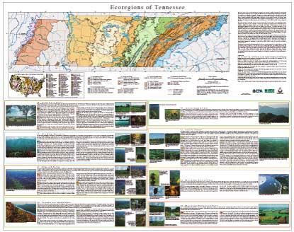
- Tennessee
GIS Data (shapefiles, metadata and symbology)
- Tennessee Level III Shapefile (292 kb)
- Tennessee Level III Metadata and Tennessee Level III Symbology
- Tennessee Level IV Shapefile (710 mb)
- Tennessee Level IV Metadata and Tennessee Level IV Symbology
- Instructions for applying symbology to ecoregions
Maps (available in PDF format)
- Level IV Ecoregions of Tennessee--poster front side 46" X 36" (1.5 mb)
- Level IV Ecoregions of Tennessee--poster back side 46" X 36" (512 kb)
- Level III and IV Ecoregions of Tennessee--36" X 22" (1.6 mb)
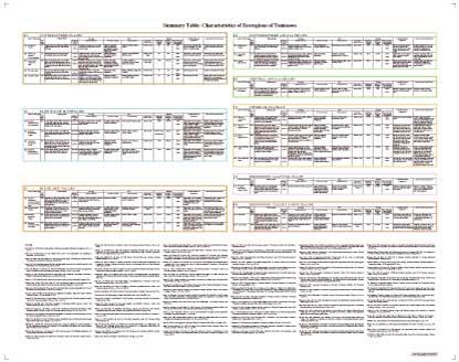
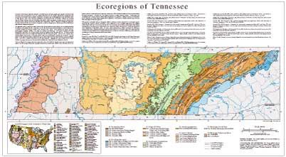
Ecoregions denote areas of general similarity in ecosystems and in the type, quality, and quantity of environmental resources; they are designed to serve as a spatial framework for the research, assessment, management, and monitoring of ecosystems and ecosystem components. Ecoregions are directly applicable to the immediate needs of state agencies, such as the Tennessee Department of Environment and Conservation (TDEC), for selecting regional stream reference sites and identifying high-quality waters, developing ecoregion-specific chemical and biological water quality criteria and standards, and augmenting TDEC’s watershed management approach. Ecoregion frameworks are also relevant to integrated ecosystem management, an ultimate goal of most federal and state resource management agencies.
The approach used to compile this map is based on the premise that ecological regions can be identified through the analysis of the patterns and the composition of biotic and abiotic phenomena that affect or reflect differences in ecosystem quality and integrity (Wiken 1986; Omernik 1987, 1995). These phenomena include geology, physiography, vegetation, climate, soils, land use, wildlife, and hydrology. The relative importance of each characteristic varies from one ecological region to another regardless of the hierarchical level. A Roman numeral hierarchical scheme has been adopted for different levels of ecological regions. Level I is the coarsest level, dividing North America into 15 ecological regions, with level II dividing the continent into 52 regions. At level III, the continental United States contains 99 regions (United States Environmental Protection Agency [USEPA] 1997). Level IV is a further subdivision of level III ecoregions. Explanations of the methods used to define USEPA’s ecoregions are given in Omernik (1995), Griffith et al. (1994, 1997), and Gallant et al. (1989).
This level III and IV ecoregion map was compiled at a scale of 1:250,000; it depicts revisions and subdivisions of earlier level III ecoregions that were originally compiled at a smaller scale (USEPA 1996; Omernik 1987). The poster is part of a collaborative project primarily between the USEPA National Health and Environmental Effects Research Laboratory - Corvallis, OR., and TDEC’s Division of Water Pollution Control. Collaboration and consultation also occurred with the United States Department of Agriculture - Natural Resources Conservation Service (NRCS), the United States Department of Agriculture - Forest Service (USFS), USEPA Region IV, and with other State of Tennessee agencies.
This project is associated with an interagency effort to develop a common framework of ecological regions. Reaching that objective requires recognition of the differences in the conceptual approaches and mapping methodologies that have been used to develop the most commonly used existing ecoregion-type frameworks, including those developed by the USFS (Bailey et al. 1994), the USEPA (Omernik 1987, 1995), and the NRCS (U.S. Department of Agriculture 1981). As each of these frameworks is further developed, the differences between them lessen. Regional collaborative projects such as this one in Tennessee, where some agreement can be reached among multiple resource management agencies, is a step in the direction of attaining commonality and consistency in ecoregion frameworks for the entire nation.
Literature Cited:
Bailey, R.G., Avers, P.E., King, T., and McNab, W.H., eds., 1994, Ecoregions and subregions of the United States (map) (supplementary table of map unit descriptions compiled and edited by McNab, W.H. and Bailey, R.G.): Washington, D.C., U.S. Department of Agriculture - Forest Service, scale 1:7,500,000.
Gallant, A.L., Whittier, T.R., Larsen, D.P., Omernik, J.M., and Hughes, R.M., 1989, Regionalization as a tool for managing environmental resources: Corvallis, Oregon, U.S.Environmental Protection Agency EPA/600/3-89/060, 152 p.
Griffith, G.E., Omernik, J.M., Wilton, T.F., and Pierson, S.M., 1994, Ecoregions and subregions of Iowa - a framework for water quality assessment and management: The Journal of the Iowa Academy of Science, v. 101, no. 1, p. 5-13.
Griffith, G.E., Omernik, J.M., and Azevedo, S.H., 1997, Ecoregions of Tennessee: Corvallis, Oregon, U.S. Environmental Protection Agency EPA/600R-97/022, 51 p.
Omernik, J.M., 1987, Ecoregions of the conterminous United States (map supplement): Annals of the Association of American Geographers, v. 77, no. 1, p. 118-125, scale 1:7,500,000.
Omernik, J.M., 1995, Ecoregions - a framework for environmental management, in Davis, W.S. and Simon, T.P., eds., Biological assessment and criteria - tools for water resource planning and decision making: Boca Raton, Florida, Lewis Publishers, p. 49-62.
U.S. Department of Agriculture - Soil Conservation Service, 1981, Land resource regions and major land resource areas of the United States: Agriculture Handbook 296, 156 p.
U.S. Environmental Protection Agency, 1997, Level III ecoregions of the continental United States (revision of Omernik, 1987): Corvallis, Oregon, U.S. Environmental Protection Agency - National Health and Environmental Effects Research Laboratory Map M-1, various scales.
Wiken, E., 1986, Terrestrial ecozones of Canada: Ottawa, Environment Canada, Ecological Land Classification Series no. 19, 26 p.
PRINCIPAL AUTHORS: Glenn Griffith (USEPA), James Omernik (USEPA) and Sandra Azevedo (OAO Corporation).
COLLABORATORS AND CONTRIBUTORS: John Jenkins (NRCS), Richard Livingston (NRCS), James Keys (USFS); Phil Stewart (TDEC), Greg Russell (TDEC), Alan Woods (Dynamac Corporation), Joy Broach (TDEC), Linda Cartwright (TDEC), Debbie Arnwine (Tennessee Department of Health), and Thomas Loveland (USGS).