Ecoregion Download Files by State - Region 5
Select a state for descriptive information about that state's Level III and IV ecoregions. Additionally, each state section contains links to downloadable maps in PDF format, and files containing GIS datasets (shapefiles, metadata, and symbology data).
Some Web content for Level IV Ecoregions is under construction. If you do not find a link to a state that has been completed, maps and GIS data are available on the Ecoregion FTP site and web content will be available shortly.
NOTE: maps and GIS files may differ. To make sure you are using the most current ecoregion data, download shapefiles of ecoregions.
- Illinois
GIS Data (shapefiles, metadata and symbology)
- Illinois Level III Shapefile (351 kb)
- Illinois Level III Metadata and Illinois Level III Symbology
- Illinois Level IV Shapefile (762 kb)
- Illinois Level IV Metadata and Illinois Level IV Symbology
- Instructions for applying symbology to ecoregions
Maps (available in PDF format)
- Level IV Ecoregions of Illinois 19 X 29" (1.3 mb)
- Level IV Ecoregions of Illinois- Page Size 8.5 X 11" ( 2 pages- includes map, legend and credits; 2.2 mb)
- Descriptions -- Level III and IV Ecoregions of Illinois text descriptions and bibliography
- Report -- Level III and IV Ecoregions of Illinois
- Summary Table: Characteristics of the Ecoregions of Illinois 46 X 36" (67 kb)
Map Thumbnails 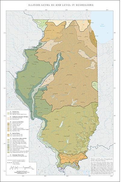 Level IV Ecoregions of Illinois 19 X 29" (1.3 mb)
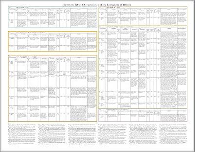 Summary Table: Characteristics of the Ecoregions of Illinois 46 X 36" (67 kb)
Ecoregions denote areas of general similarity in ecosystems, and in the type, quality, and quantity of environmental resources. They are general purpose regions that are useful for structuring and implementing ecosystem management strategies across political boundaries (such as state lines) and across agencies (Omernik and others, 2000). Ecoregions stratify the environment according to its probable response to disturbance, and recognize the spatial differences in the capacities and potentials of ecosystems (Bryce, Omernik, and Larsen, 1999).
Ecoregion frameworks are useful for 1) inventorying and assessing national and regional environmental resources, 2) setting regional resource management goals, 3) establishing geographical research frameworks, and 4) developing regional biological criteria and water quality standards (Arkansas Department of Pollution Control and Ecology, 1988; Bazata, 1991; Environment Canada, 1989; Gallant and others, 1989; Heiskary and Wilson, 1989; Hughes, 1989b; Hughes and others, 1987, 1990, 1994; Larsen and others, 1986; Lyons, 1989; Ohio Environmental Protection Agency, 1988; Plotnikoff, 1992; Rohm and others, 1987; U.S. Environmental Protection Agency, Science Advisory Board, 1991; Warry and Hanau, 1993; Whittier and others, 1988).
Ecoregion frameworks have been developed for several countries, including the United States, Canada, New Zealand, and the Netherlands (Bailey, 1976, 1983, 1995; Bailey and others, 1985, 1994; Biggs and others, 1990; Ecological Stratification Working Group, 1995; Klijn, 1994; Omernik, 1987, 1995a; Omernik and Gallant, 1990; U.S. Environmental Protection Agency, 2005; Wiken, 1986). The first compilation of ecoregions in the conterminous United States by the U.S. Environmental Protection Agency (U.S. EPA) was performed at a relatively cursory scale (1:3,168,000), and was published at a smaller scale (1:7,500,000) (Omernik, 1987). Subsequently, this ecoregion framework was expanded to include Alaska and all of North America, revised, and made hierarchical (Gallant and others, 1995; Omernik, 1995b; U.S. Environmental Protection Agency, 2005).
Level I is the coarsest level in the ecoregion hierarchy; it divides North America into 15 ecological regions. Level II divides the continent into 50 regions. At level III, the continental United States contains 104 ecoregions, whereas the conterminous United States has 84. Level IV ecological regions are further subdivisions of level III ecoregions. The exact number of ecological regions at each hierarchical level is still changing slightly as the framework undergoes development at the international, national, and state levels.
Detail resolution on Omernik’s (1987) ecoregion map of the conterminous United States was necessarily limited by its rather small scale of 1:7,500,000. Subsequently, many larger scale, collaborative, state projects refined Omernik’s original ecoregion map, and subdivided its level III ecoregions into level IV ecoregions. Completed level IV ecoregion projects cover Alabama, Arkansas, Colorado, Connecticut, Delaware, Florida, Georgia, Idaho, Indiana, Iowa, Kansas, Kentucky, Louisiana, Maryland, Massachusetts, Mississippi, Missouri, Montana, Nebraska, Nevada, North Carolina, North Dakota, Ohio, Oklahoma, Oregon, Pennsylvania, Rhode Island, South Carolina, South Dakota, Tennessee, Texas, Utah, Virginia, Washington, West Virginia, Wisconsin, and Wyoming. Other state level IV ecoregion projects are still in progress including Minnesota, New Jersey, and New Mexico. These level IV ecoregion projects have involved state agencies, U.S. EPA regional offices, and the U.S. EPA–Center for Public Health and Environmental Assessment, Pacific Ecological Systems Division in Corvallis, Oregon. Projects have included participation by the U.S. Department of Agriculture–Natural Resources Conservation Service and the U.S. Department of Agriculture–Forest Service as part of an interagency effort to develop a common framework of ecological regions.
In this paper we refine the level III ecoregions of Illinois, subdivide them into more detailed level IV subdivisions, and provide descriptions and summary information for each ecoregion in the state. Illinois has 6 level III and 25 level IV ecoregions; all but 8 continue into ecologically similar parts of adjacent states (Chapman and others, 2001, 2002; Griffith, 1994; Omernik and others, 2000; Woods and others, 1998, 2002).
The work in Illinois was done in cooperation with U.S. EPA Region 5. The Illinois ecoregionalization project involved personnel from several state agencies, federal agencies, and universities, including the Illinois Environmental Protection Agency (Illinois EPA), Illinois Natural History Survey, Illinois State Geological Survey, Illinois State Water Survey, U.S. Department of Agriculture–Natural Resources Conservation Service (NRCS), and Eastern Illinois University. This project was partly conducted under the auspices of the Program for Cooperative Research on Aquatic Indicators Award # CR-831682-01.
The procedures used to define Illinois ecoregions are consistent with those that were used in preceding U.S. EPA ecoregion studies of neighboring states (Chapman and others, 2001, 2002; Griffith, 1994; Omernik and others, 2000; Woods and others, 1998, 2002). They are based on the premise that ecological regions can be identified through the analysis of biotic and abiotic characteristics that affect or reflect differences in ecosystem quality and integrity (Omernik, 1987, 1995a; Wiken, 1986). Spatial pattern, composition, and spatial correspondence of physiography, natural vegetation, soil, surficial and bedrock geology, climate, land use, land cover, wildlife, and fish were considered as part of the process. The relative importance of each biotic and abiotic characteristic varied from one ecological region to another regardless of the ecoregion hierarchical level. Expert judgment was employed throughout the selection, analysis, and classification of data to define the ecoregions. Information from the literature and input from state and regional experts were very important to this project, as well as the earlier ones in neighboring states. Ecoregion lines were compiled at 1:250,000-scale onto 1:250,000-scale topographic base maps. More detailed explanations about the methods, materials, rationale, and philosophy for the ecoregionalization process can be found in Gallant and others (1989), Omernik (1995a), and Omernik and Gallant (1990).
Evaluation of the ecoregion framework presented in this paper is a necessary future step. U.S. EPA ecoregions have been evaluated extensively in the past, and the most meaningful of these efforts have involved the use of measures of water quality and indices of biotic integrity (IBI’s) (Hughes, 1989a; Larsen and others, 1986, 1988; Whittier and others, 1987; Yoder and Rankin, 1995). A better tool would be a more encompassing index of ecological integrity (IEI) (Omernik, 1995a, 1995b); although an IEI is not available yet, there is considerable interest in at least two states to begin its development. Verification of ecoregions cannot be done by considering individual ecosystem components; this is because the ecoregion framework was not intended to show regional patterns specific to either the flora or fauna of terrestrial ecosystems, nor was it intended to reflect distributions of fish or aquatic macroinvertebrates.
Literature Cited:
Arkansas Department of Pollution Control and Ecology, 1988, Regulations establishing water quality standards for surface waters of the State of Arkansas: Little Rock, Arkansas Department of Pollution Control and Ecology.
Bailey, R.G., 1976, Ecoregions of the United States (map): Ogden, Utah, U.S. Department of Agriculture–Forest Service, Intermountain Region, scale 1:7,500,000.
Bailey, R.G., 1983, Delineation of ecosystem regions: Environmental Management. v. 7, p. 365-373.
Bailey, R.G., 1995, Ecosystem Geography: New York: Springer-Verlag.
Bailey, R.G., Avers, P. E., King, T., and McNab, W.H., 1994, Ecoregions and subregions of the United States (map and table): U.S. Department of Agriculture–Forest Service, scale 1:7,500,000.
Bailey, R.G., Zoltai, S.C., and Wiken, E.B., 1985, Ecoregionalization in Canada and the United States: Geoforum, v. 16, no. 3, p. 265-275.
Bazata, K., 1991, Nebraska stream classification study: Lincoln, Nebraska Department of Environmental Control, Water Quality Division, Surface Water Section.
Biggs, B.J.F., Duncan, M.J., Jowett, I.G., Quinn, J.M., Hickey, C.W., Davis-Colley, R.J., and Close, M.E., 1990, Ecological characterization, classification, and modelling of New Zealand rivers – an introduction and synthesis: New Zealand Journal of Marine and Freshwater Research, v. 24, p. 277-304.
Bryce, S.A., Omernik, J.M., and Larsen, D.P., 1999, Ecoregions – a geographic framework to guide risk characterization and ecosystem management: Environmental Practice, v. 1, no. 3, p. 141-155.
Chapman, S.S., Omernik, J.M., Freeouf, J.A., Huggins, D.G., McCauley, J.R., Freeman, C.C., Steinauer, G., Angelo, R.T., and Schlepp, R.L., 2001, Ecoregions of Nebraska and Kansas: Reston, Virginia, U.S. Geological Survey, map scale 1:1,950,000.
Chapman, S.S., Omernik, J.M., Griffith, G.E., Schroeder, W.A., Nigh, T.A., and Wilton, T.F., 2002, Ecoregions of Iowa and Missouri: Reston, Virginia, U.S. Geological Survey, map scale 1:1,800,000.
Ecological Stratification Working Group, 1995, A National Ecological Framework for Canada (report and national map): Ottawa/Hull, Agriculture and Agri-Food Canada, Research Branch, Centre for Land and Biological Resources Research and Environment Canada, State of the Environment Directorate, Ecozone Analysis Branch, scale 1:7,500,000.
Environment Canada, 1989, Canada Committee on Ecological Land Classification – Achievements (1976-1989) and Long-term Plan: Ottawa, Ontario, Environment Canada.
Gallant, A. L., Binnian, E.F., Omernik, J.M., and Shasby, M.B., 1995, Ecoregions of Alaska: U.S. Geological Survey Professional Paper 1567.
Gallant, A.L., Whittier, T.R., Larsen, D.P., Omernik, J.M., and Hughes, R.M., 1989, Regionalization as a Tool for Managing Environmental Resources: Corvallis, Oregon, U.S. Environmental Protection Agency EPA/600/3-89/060.
Griffith, G.E., Omernik, J.M., Wilton, T.F., and Pierson, S.M., 1994. Ecoregions and subregions of Iowa; a framework for water quality assessment and management: The Journal of the Iowa Academy of Science, v. 101, no. 1, p. 5-13.
Heiskary, S.A., and Wilson, C.B., 1989, The regional nature of lake quality across Minnesota – an analysis for improving resource management: Journal of the Minnesota Academy of Science, v. 55, no. 1, p. 71-77.
Hughes, R.M., 1989a, The IBI – a quantitative, easily communicated assessment of the health and complexity of entire fish communities: Biological Report, v. 90, no. 5, p. 26-28.
Hughes, R.M, 1989b, Ecoregional biological criteria, in Water Quality Standards for the 21st Century: Dallas, Texas, Proceedings of an U.S. Environmental Protection Agency Conference, 147-151.
Hughes, R.M., Whittier, T.R., Rohm, C.M., and Larsen, D.P., 1990, A regional framework for establishing recovery criteria: Environmental Management, v. 14, no. 5, p. 673-683.
Hughes, R.M., Heiskary, S.A., Mathews, W.J., and Yoder, C.O., 1994, Use of ecoregions in biological monitoring in Loeb, S.L., and Spacie, A. (eds.), Biological Monitoring of Aquatic Systems: Boca Raton, Florida, Lewis Publishers, p. 125-151.
Hughes, R.M., Rexstad, E., and Bond, C.E., 1987, The relationship of aquatic ecoregions, river basins, and physiographic provinces to the ichthyogeographic regions of Oregon: Copeia 1987, no. 2, p. 423-432.
Klijn, F., 1994, Spatially nested ecosystems – guidelines for classification from a hierarchical perspective in Klijn, F. (ed.), Ecosystem Classification for Environmental Management: Dordrecht, The Netherlands, Kluwer Academic Publishers, p. 85-116.
Larsen, D.L., Dudley, D.R., and Hughes, R.M., 1988, A regional approach to assess attainable water quality -- an Ohio case study: Journal of Soil and Water Conservation, v. 43, no. 2, p. 171-176.
Larsen, D.P., Hughes, R.M., Omernik, J.M., Dudley, D.R., Rohm, C.M., Whittier, T.R., Kinney, A.J., and Gallant, A.L., 1986, The correspondence between spatial patterns in fish assemblages in Ohio streams and aquatic ecoregions: Environmental Management, v. 10, p. 815-828.
Lyons, J., 1989, Correspondence between the distributions of fish assemblages in Wisconsin streams and Omernik’s ecoregions: American Midland Naturalist, v. 122, no. 1, p. 163-182.
Ohio Environmental Protection Agency, 1988, Biological Criteria for the Protection of Aquatic Life. Volume 1: The Role of biological data in water quality assessment: Columbus, Ohio Environmental Protection Agency.
Omernik, J.M., 1995a, Ecoregions: a spatial framework for environmental management, in Davis, W.S. and Simon, T.P. (eds.), Biological assessment and criteria, tools for water resource planning and decision making: Boca Raton, Florida, Lewis Publishers, p. 31-47.
Omernik, J.M., 1995b, Ecoregions: a framework for managing ecosystems: The George Wright Forum, v. 12, no. 1, p. 35-50.
Omernik, J.M., 1987, Ecoregions of the conterminous United States (map supplement): Annals of the Association of American Geographers, v. 77, no. 1, p. 118-125, map scale 1:7,500,000.
Omernik, J.M., Chapman, S.S., Lillie, R.A., and Dumke. R.T., 2000, Ecoregions of Wisconsin: Transactions of the Wisconsin Academy of Science, Arts and Letters, v. 88, p. 77-103.
Omernik, J.M., and Gallant, A.L., 1990, Defining regions for evaluating environmental resources, in Global natural resource monitoring and assessments – preparing for the 21st century – proceedings of the international conference and workshop, September 24-30, 1989, Fondazione G. Cini, Isle of San Giorgio Maggiore, Venice, Italy, v. 2, 936-947: Bethesda, Maryland, American Society for Photogrammetry and Remote Sensing.
Plotnikoff, R.W., 1992, Timber/Fish/Wildlife Ecoregion Bioassessment Pilot Project: Olympia, Washington Department of Ecology.
Rohm, C.M., Giese, J.W., and Bennett, C.C., 1987, Evaluation of an aquatic ecoregion classification of streams in Arkansas: Journal of Freshwater Ecology, v. 4, no. 1, p. 127-140.
U.S. Environmental Protection Agency, 2005, Level III ecoregions of the continental United States (revision of Omernik, 1987): Corvallis, Oregon: U.S. Environmental Protection Agency–National Health and Environmental Effects Research Laboratory Map M-1, various scales.
U.S. Environmental Protection Agency, Science Advisory Board, 1991, Evaluation of the ecoregion concept. Report of the ecoregions subcommittee of the ecological processes and effects committee: Washington, D.C., U.S. Environmental Protection Agency, EPA/SAB/EPEC/91/003.
Warry, N.D., and Hanau, M., 1993, The use of terrestrial ecoregions as a regional-scale screen for selecting representative reference sites for water quality monitoring: Environmental Management, v. 17, no. 2, p. 267-276.
Whittier, T.R., Hughes, R.M., and Larsen, D.P., 1988, The correspondence between ecoregions and spatial patterns in stream ecosystems in Oregon: Canadian Journal of Fisheries and Aquatic Sciences, v. 45, p. 1264-1278.
Whittier, T.R., Larsen, D.P., Hughes, R.M., Rohm, C.M., Gallant, A.L., and Omernik, J.M., 1987, The Ohio stream regionalization project: a compendium of results: Corvallis, Oregon: U.S. Environmental Protection Agency, Environmental Research Laboratory, EPA/600/3/-87/025.
Wiken, E., 1986, Terrestrial Ecozones of Canada: Ottawa, Canada, Environment Canada, Ecological Land Classification Series No. 19.
Woods, A.J., Omernik, J.M., Brockman, C.S., Gerber, T.D., Hosteter, W.D, and Azevedo, S.H., 1998, Ecoregions of Indiana and Ohio (2-sided color poster with map, descriptive text, summary tables, and photographs): Reston, Virginia, U.S. Geological Survey, scale 1:500,000.
Woods, A.J., Omernik, J.M., Martin, W.H., Pond, G.J., Andrews, W.M., Call, S.M., Comstock, J.A., and Taylor. D.D., 2002, Ecoregions of Kentucky. (2-sided color poster with map, descriptive text, summary tables, and photographs): Reston, Virginia, U.S. Geological Survey, scale 1:1,000,000.
Yoder, C.O., and Rankin, E.T., 1995, Biological criteria program development and implementation in Ohio, in Davis, W.S., and Simon, T.P. (eds.), Biological assessment and criteria, tools for water resource planning and decision making: Boca Raton, Florida, Lewis Publishers, p. 109-144
PRINCIPAL AUTHORS: Alan J. Woods (Oregon State University), James M. Omernik (U.S. Geological Survey), Charles L. Pederson (Department of Biological Sciences, Eastern Illinois University), and Brian C. Moran (Indus Corporation).
COLLABORATORS AND CONTRIBUTORS: Candice Bauer (U.S. Environmental Protection Agency), Bill Ettinger (Illinois Environmental Protection Agency), Gregg Good (Illinois Environmental Protection Agency), Ed Hammer (U.S. Environmental Protection Agency), Mark Joseph (Illinois Environmental Protection Agency), Don Keefer (Illinois State Geological Survey), Laura Keefer (Illinois State Water Survey, Andrew Phillips (Illinois State Geological Survey), Don Pitts (U.S. Department of Agriculture–Natural Resources Conservation Service), Mike Retzer (Illinois Natural History Survey), and Roy Smoger (Illinois Environmental Protection Agency).
- Indiana
GIS Data (shapefiles, metadata and symbology)
- Indiana Level III Shapefile (244 kb)
- Indiana Level III Metadata and Indiana Level III Symbology
- Indiana Level IV Shapefile (319 kb)
- Indiana Level IV Metadata and Indiana Level IV Symbology
- Instructions for applying symbology to ecoregions
Maps (available in PDF format)
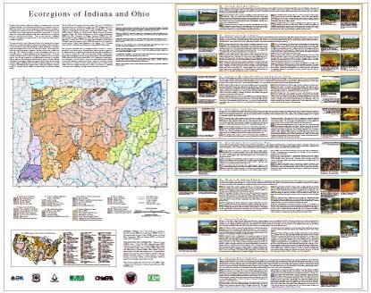
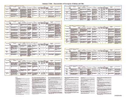
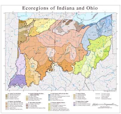
- Level IV Ecoregions of Indiana and Ohio--poster front side 46" X 36" (4.3 mb)
- Level IV Ecoregions of Indiana and Ohio--poster back side 46" X 36" (608 kb)
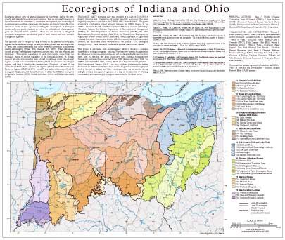
- Level III and IV Ecoregions of Indiana and Ohio--24" X 26" (1 mb)
- Level III and IV Ecoregions of Indiana and Ohio--page size (832 kb)
Ecoregions denote areas of general similarity in ecosystems and in the type, quality, and quantity of environmental resources; they are designed to serve as a spatial framework for the research, assessment, management, and monitoring of ecosystems and ecosystem components. Ecoregions are directly applicable to the immediate needs of state agencies including the development of biological criteria and water quality standards as well as the establishment of management goals for nonpoint-source pollution. They are also relevant to integrated ecosystem management, an ultimate goal of most federal and state resource management agencies.
The approach used to compile this map is based on the premise that ecological regions can be identified through the analysis of the patterns and the composition of biotic and abiotic phenomena that affect or reflect differences in ecosystem quality and integrity (Wiken 1986; Omernik 1987, 1995). These phenomena include geology, physiography, vegetation, climate, soils, land use, wildlife, and hydrology. The relative importance of each characteristic varies from one ecological region to another regardless of the hierarchical level. A Roman numeral hierarchical scheme has been adopted for different levels of ecological regions. Level I is the coarsest level, dividing North America into 15 ecological regions, with level II dividing the continent into 52 regions. At level III, the continental United States contains 99 regions (United States Environmental Protection Agency [USEPA], 1997). Level IV is a further subdivision of level III ecoregions. Explanations of the methods used to define the USEPA’s ecoregions are given in Omernik (1995), Griffith and others (1994), and Gallant and others (1989).
This level III and IV ecoregion map was compiled at a scale of 1:250,000; it depicts revisions and subdivisions of earlier level III ecoregions that were originally compiled at a smaller scale (USEPA 1997; Omernik 1987). The poster is part of a collaborative project primarily between the USEPA Region V, the USEPA Center for Public Health and Environmental Assessment - Pacific Ecological Systems Division, Corvallis, Oregon, the Indiana Department of Environmental Management (IDEM), the Ohio Department of Natural Resources (ODNR), the Ohio Environmental Protection Agency (Ohio EPA), the United States Department of Agriculture - Forest Service (USFS), the United States Department of Agriculture - Natural Resources Conservation Service (NRCS) (formerly the Soil Conservation Service), and the United States Department of the Interior - U.S. Geological Survey (USGS) - Earth Resources Observation Systems (EROS) Data Center.
This project is associated with an interagency effort to develop a common framework of ecological regions. Reaching that objective requires recognition of the differences in the conceptual approaches and mapping methodologies that have been used to develop the most commonly used existing ecoregion-type frameworks, including those developed by the USFS (Bailey and others, 1994), the USEPA (Omernik 1987, 1995), and the NRCS (U.S. Department of Agriculture - Soil Conservation Service, 1981). As each of these frameworks is further developed, the differences between them lessen. Regional collaborative projects such as this one in Indiana and Ohio, where agreement can be reached among multiple resource management agencies, is a step in the direction of attaining commonality and consistency in ecoregion frameworks for the entire nation.
Literature Cited:
Bailey, R.G., Avers, P.E., King, T., and McNab, W.H., eds., 1994, Ecoregions and subregions of the United States (map) (supplementary table of map unit descriptions compiled and edited by McNab, W.H. and Bailey, R.G.): Washington, D.C., U.S. Department of Agriculture - Forest Service, scale 1:7,500,000.
Gallant, A.L., Whittier, T.R., Larsen, D.P., Omernik, J.M., and Hughes, R.M., 1989, Regionalization as a tool for managing environmental resources: Corvallis, Oregon, U.S. Environmental Protection Agency EPA/600/3-89/060, 152 p.
Griffith, G.E., Omernik, J.M., Wilton, T.F., and Pierson, S.M., 1994, Ecoregions and subregions of Iowa - a framework for water quality assessment and management: The Journal of the Iowa Academy of Science, v. 101, no. 1, p. 5-13.
Omernik, J.M., 1987, Ecoregions of the conterminous United States (map supplement): Annals of the Association of American Geographers, v. 77, no. 1, p. 118-125, scale 1:7,500,000.
Omernik, J.M., 1995, Ecoregions - a framework for environmental management, in Davis, W.S. and Simon, T.P., eds., Biological assessment and criteria - tools for water resource planning and decision making: Boca Raton, Florida, Lewis Publishers, p. 49-62.
U.S. Department of Agriculture - Soil Conservation Service, 1981, Land resource regions and major land resource areas of the United States: Agriculture Handbook 296, 156 p.
U.S. Environmental Protection Agency, 1997, Level III ecoregions of the continental United States (revision of Omernik, 1987): Corvallis, Oregon, U.S. Environmental Protection Agency - National Health and Environmental Effects Research Laboratory Map M-1, various scales.
Wiken, E., 1986, Terrestrial ecozones of Canada: Ottawa, Environment Canada, Ecological Land Classification Series no. 19, 26 p.
PRINCIPAL AUTHORS: Alan J. Woods (Dynamac Corporation), James M. Omernik (USEPA), C. Scott Brockman (ODNR - Division of Geological Survey), Timothy D. Gerber (ODNR - Division of Soil and Water Conservation), William D. Hosteter (NRCS), and Sandra H. Azevedo (OAO Corporation)
COLLABORATORS AND CONTRIBUTORS: Thomas P. Simon (USEPA), Chris O. Yoder (Ohio EPA), Patrick Merchant (USFS), Thomas R. Loveland (USGS), C. Lee Bridges (IDEM - Office of Water - Biological Studies Section), Gary L. Overmier (NRCS), Kelly Capuzzi (Ohio EPA), Steven A. Newhouse (IDEM - Office of Water - Biological Studies Section), Tom Nash (National Park Service - Cuyahoga National Recreation Area), James R. Gammon (Professor Emeritus of Zoology, DePauw University), Barbara K. Andreas (Professor of Biology, Cuyahoga Community College), and John Harrington (Professor, Department of Geography, Kansas State University)
This project was partially supported by funds from the USEPA - Office of Research and Development - Regional Applied Research Effort (RARE) program.
- Michigan
GIS Data (shapefiles, metadata and symbology)
- Michigan Level III Shapefile (1.2 mb)
- Michigan Level III Metadata and Michigan Level III Symbology
- Michigan Level IV Shapefile (1.4 mb)
- Michigan Level IV Metadata and Michigan Level IV Symbology
- Instructions for applying symbology to ecoregions
Maps (available in PDF format)
- Level III and IV Ecoregions of Michigan--map 30" X 32" (5 mb)
- Level III and IV Ecoregions of Michigan text descriptions and mapping issues
Map Thumbnail 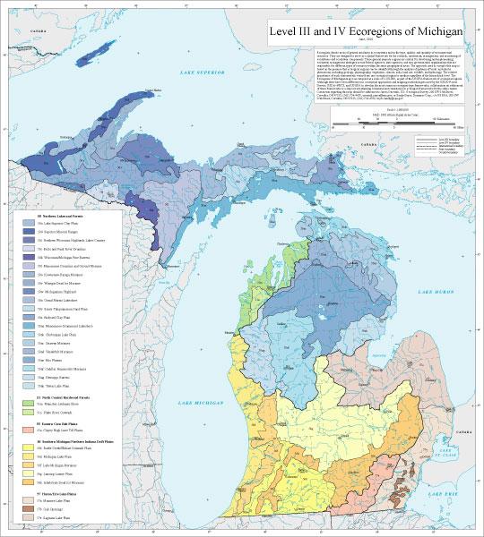 Level III and IV Ecoregions of Michigan--map 30" X 32" (5 mb)
Ecoregions denote areas of general similarity in ecosystems and in the type, quality, and quantity of environmental resources. They are designed to serve as a spatial framework for the research, assessment, management, and monitoring of ecosystems and ecosystem components. These general purpose regions are critical for structuring and implementing ecosystem management strategies across federal agencies, state agencies, and non-governmental organizations that are responsible for different types of resources within the same geographical areas. The approach used to compile this map is based on the premise that ecological regions can be identified through the analysis of patterns of biotic and abiotic phenomena, including geology, physiography, vegetation, climate, soils, land use, wildlife, and hydrology. The relative importance of each characteristic varies from one ecological region to another regardless of the hierarchical level. The Ecoregions of Michigan map was compiled at a scale of 1:250,000, as part of the US EPA framework of ecological regions. Although there have been differences in conceptual approaches and mapping methodologies used by the USDA–Forest Service, USDA–NRCS, and US EPA to develop the most common ecoregion-type frameworks, collaboration on refinement of these frameworks is a step toward attaining consensus and consistency in ecoregion frameworks for the entire nation. Comments regarding this map should be addressed to James Omernik, U.S. Geological Survey, 200 SW 35th Street, Corvallis, OR 97333, (541) 754-4458, omernik.james@epa.gov; or Sandy Bryce, Dynamac Corp., c/o US EPA, 200 SW 35th Street, Corvallis, OR 97333, (541) 754-4788, bryce.sandy@epa.gov.
- Minnesota
GIS Data (shapefiles, metadata and symbology)
- Minnesota Level III Shapefile (445 kb)
- Minnesota Level III Metadata and Minnesota Level III Symbology
- Minnesota Level IV Shapefile (656 kb)
- Minnesota Level IV Metadata and Minnesota Level IV Symbology
- Instructions for applying symbology to ecoregions
Maps (available in PDF format)
- Level III and IV Ecoregions of Minnesota 11 X 17" (615 kb)
- Level IV Ecoregions of Minnesota text descriptions
Map Thumbnail 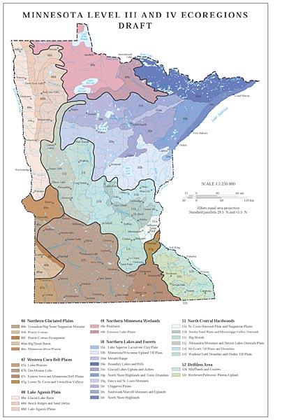 Level III and IV Ecoregions of Minnesota 11 X 17" (615 kb)
The work on the initial version of ecological regions for the conterminous US, subsequently becoming Level III, was conducted in the mid-1980s by Omernik and published in 1987. This work was "based on the hypothesis that ecosystems and their components display regional patterns that are reflected in spatially variable combinations of causal factors. These causal factors include climate, mineral availability (soils and geology), vegetation, and physiography. Although these factors interact, the importance of each factor in determining the character of ecosystems varies from place to place." Omernik argued that "by analyzing a combination of small scale maps of the important causal factors and of integrative factors (such as land use), distinct regional patterns of ecosystems can be perceived" (quotations in this paragraph from Omernik 1987). These level III ecoregions have been used for assessment and management of rivers and lakes in Minnesota (Heiskary and various others 1987, 1988, 1989, 2008, 2019; Ramstack and others 2004; Anderson and others 2016).
The work on Level IV described here was conducted under the aegis of the Omernik system and started with the Omernik Level III ecoregions as a basis. The method of discovery is described in some detail in Omernik and Griffith's 2014 paper. The process in Minnesota included in the early stages two visits to Minnesota to talk with potential users of more detailed ecoregions. Many maps of relevant phenomena were assembled from some materials already available at the US EPA research laboratory in Corvallis, and from sources online. Some of the maps that have been used are represented in Appendix M. Also, considerable literature was assembled on soils, vegetation, wildlife, geology, and geography. The references in the report list most of these documents.
With these many materials to assist, patterns among them were studied and compared until the accumulated knowledge suggested the appropriate division of the Level III regions into subregions, with possible minor changes to the boundaries of Level III also. This process, as with any regionalization process, cannot be considered a final reckoning of the ecoregionality of Minnesota because not only will further knowledge affect possible changes, but the forces of change interact in complex ways and change themselves in spatial distribution and importance.
Literature Cited:
Anderson, Pam, and 18 others. 2016. Guidance Manual for assessing the quality of Minnesota surface waters for determination of impairment: 305(b) report and 303(d) list. Minnesota Pollution Control Agency. 77 pages.
Heiskary, Steven, C B Wilson, D P Larsen. 1987. Analysis of regional patterns in lake water quality: Using ecoregions for lake management in Minnesota. Lake and Reservoir Managment. 3:337-344.
Heiskary, Steven, W W Walker Jr. 1988. Developing nutrient criteria for Minnesota lakes. Lake and Reservoir Management 4:1-9.
Heiskary, Steven, Bruce Wilson. 1989. The regional nature of lake water quality across Minnesota: an analysis for improving resource management. Journal of the Minnesota Academy of Sciences 55:71-77.
Heiskary, Steven, Bruce Wilson. 2008. Minnesota's approach to lake nutrient criteria development. Lake and Reservoir Management 24:282-297.
Heiskary, Steven, Kristofor Parson. 2019. Regionalization of Minnesota's rivers for application of river nutrient criteria. Minnesota Pollution Control Agency. 32 pages. URL: https://www.pca.state.mn.us/sites/default/files/wq-s6-18.pdf
Omernik, James M, 1987, Ecoregions of the Conterminous United States (Map Supplement): Annals of the Association of American Geographers, v. 77, p. 118-125, scale 1:7,500,000.
Omernik, James M, Glenn E Griffith. 2014. Ecoregions of the Conterminous Unites States: Evolution of a Hierarchical Spatial Framework. Environmental Management 54:1249-1266.
Ramstack, Joy M, Sherilyn C Fritz, Daniel R Engstrom. 2004. Twentieth century water quality trends in Minnesota lakes compared with presettlement variability. Canadian Journal of Fisheries and Aquatic Sciences 61:561-576.
AUTHOR: Denis White, retired US EPA; courtesy faculty, Geography Program, Oregon State University.
COLLABORATORS AND CONTRIBUTORS: Glenn Griffith, US Geological Survey; James Omernik, USGS Geological Survey; Alan Woods, retired; Steve Heiskary, Retired MN PCA.
CITING THE Report: White, Denis. 2020. Ecological Regions of Minnesota: Level III and IV maps and descriptions. 22 pages text, 69 pages appendices.
- Ohio
GIS Data (shapefiles, metadata and symbology)
- Ohio Level III Shapefile (404 kb)
- Ohio Level III Metadata and Ohio Level III Symbology
- Ohio Level IV Shapefile (471 kb)
- Ohio Level IV Metadata and Ohio Level IV Symbology
- Instructions for applying symbology to ecoregions
Maps (available in PDF format)
- Level IV Ecoregions of Indiana and Ohio--poster front side 46" X 36" (4.3 mb)
- Level IV Ecoregions of Indiana and Ohio--poster back side 46" X 36" (608 kb)
- Level III and IV Ecoregions of Indiana and Ohio--24" X 26" (1 mb)
- Level III and IV Ecoregions of Indiana and Ohio--page size (832 kb)
Ecoregions denote areas of general similarity in ecosystems and in the type, quality, and quantity of environmental resources; they are designed to serve as a spatial framework for the research, assessment, management, and monitoring of ecosystems and ecosystem components. Ecoregions are directly applicable to the immediate needs of state agencies including the development of biological criteria and water quality standards as well as the establishment of management goals for nonpoint-source pollution. They are also relevant to integrated ecosystem management, an ultimate goal of most federal and state resource management agencies.
The approach used to compile this map is based on the premise that ecological regions can be identified through the analysis of the patterns and the composition of biotic and abiotic phenomena that affect or reflect differences in ecosystem quality and integrity (Wiken 1986; Omernik 1987, 1995). These phenomena include geology, physiography, vegetation, climate, soils, land use, wildlife, and hydrology. The relative importance of each characteristic varies from one ecological region to another regardless of the hierarchical level. A Roman numeral hierarchical scheme has been adopted for different levels of ecological regions. Level I is the coarsest level, dividing North America into 15 ecological regions, with level II dividing the continent into 52 regions. At level III, the continental United States contains 99 regions (United States Environmental Protection Agency [USEPA], 1997). Level IV is a further subdivision of level III ecoregions. Explanations of the methods used to define the USEPA’s ecoregions are given in Omernik (1995), Griffith and others (1994), and Gallant and others (1989).
This level III and IV ecoregion map was compiled at a scale of 1:250,000; it depicts revisions and subdivisions of earlier level III ecoregions that were originally compiled at a smaller scale (USEPA 1997; Omernik 1987). The poster is part of a collaborative project primarily between the USEPA Region V, the USEPA Center for Public Health and Environmental Assessment - Pacific Ecological Systems Division, Corvallis, Oregon, the Indiana Department of Environmental Management (IDEM), the Ohio Department of Natural Resources (ODNR), the Ohio Environmental Protection Agency (Ohio EPA), the United States Department of Agriculture - Forest Service (USFS), the United States Department of Agriculture - Natural Resources Conservation Service (NRCS) (formerly the Soil Conservation Service), and the United States Department of the Interior - U.S. Geological Survey (USGS) - Earth Resources Observation Systems (EROS) Data Center.
This project is associated with an interagency effort to develop a common framework of ecological regions. Reaching that objective requires recognition of the differences in the conceptual approaches and mapping methodologies that have been used to develop the most commonly used existing ecoregion-type frameworks, including those developed by the USFS (Bailey and others, 1994), the USEPA (Omernik 1987, 1995), and the NRCS (U.S. Department of Agriculture - Soil Conservation Service, 1981). As each of these frameworks is further developed, the differences between them lessen. Regional collaborative projects such as this one in Indiana and Ohio, where agreement can be reached among multiple resource management agencies, is a step in the direction of attaining commonality and consistency in ecoregion frameworks for the entire nation.
Literature Cited:
Bailey, R.G., Avers, P.E., King, T., and McNab, W.H., eds., 1994, Ecoregions and subregions of the United States (map) (supplementary table of map unit descriptions compiled and edited by McNab, W.H. and Bailey, R.G.): Washington, D.C., U.S. Department of Agriculture - Forest Service, scale 1:7,500,000.
Gallant, A.L., Whittier, T.R., Larsen, D.P., Omernik, J.M., and Hughes, R.M., 1989, Regionalization as a tool for managing environmental resources: Corvallis, Oregon, U.S. Environmental Protection Agency EPA/600/3-89/060, 152 p.
Griffith, G.E., Omernik, J.M., Wilton, T.F., and Pierson, S.M., 1994, Ecoregions and subregions of Iowa - a framework for water quality assessment and management: The Journal of the Iowa Academy of Science, v. 101, no. 1, p. 5-13.
Omernik, J.M., 1987, Ecoregions of the conterminous United States (map supplement): Annals of the Association of American Geographers, v. 77, no. 1, p. 118-125, scale 1:7,500,000.
Omernik, J.M., 1995, Ecoregions - a framework for environmental management, in Davis, W.S. and Simon, T.P., eds., Biological assessment and criteria - tools for water resource planning and decision making: Boca Raton, Florida, Lewis Publishers, p. 49-62.
U.S. Department of Agriculture - Soil Conservation Service, 1981, Land resource regions and major land resource areas of the United States: Agriculture Handbook 296, 156 p.
U.S. Environmental Protection Agency, 1997, Level III ecoregions of the continental United States (revision of Omernik, 1987): Corvallis, Oregon, U.S. Environmental Protection Agency - National Health and Environmental Effects Research Laboratory Map M-1, various scales.
Wiken, E., 1986, Terrestrial ecozones of Canada: Ottawa, Environment Canada, Ecological Land Classification Series no. 19, 26 p.
PRINCIPAL AUTHORS: Alan J. Woods (Dynamac Corporation), James M. Omernik (USEPA), C. Scott Brockman (ODNR - Division of Geological Survey), Timothy D. Gerber (ODNR - Division of Soil and Water Conservation), William D. Hosteter (NRCS), and Sandra H. Azevedo (OAO Corporation)
COLLABORATORS AND CONTRIBUTORS: Thomas P. Simon (USEPA), Chris O. Yoder (Ohio EPA), Patrick Merchant (USFS), Thomas R. Loveland (USGS), C. Lee Bridges (IDEM - Office of Water - Biological Studies Section), Gary L. Overmier (NRCS), Kelly Capuzzi (Ohio EPA), Steven A. Newhouse (IDEM - Office of Water - Biological Studies Section), Tom Nash (National Park Service - Cuyahoga National Recreation Area), James R. Gammon (Professor Emeritus of Zoology, DePauw University), Barbara K. Andreas (Professor of Biology, Cuyahoga Community College), and John Harrington (Professor, Department of Geography, Kansas State University)
This project was partially supported by funds from the USEPA - Office of Research and Development - Regional Applied Research Effort (RARE) program.
- Wisconsin
GIS Data (shapefiles, metadata and symbology)
- Wisconsin Level III Shapefile (445 kb)
- Wisconsin Level III Metadata and Wisconsin Level III Symbology
- Wisconsin Level IV Shapefile (541 kb)
- Wisconsin Level IV Metadata and Wisconsin Level IV Symbology
- Instructions for applying symbology to ecoregions
Maps (available in PDF format)
- Level IV Ecoregions of Wisconsin--map and descriptions 30" X 40" (2 mb)
- Level III and IV Ecoregions of Wisconsin--22" X 22" (744 kb)
- Level III and IV Ecoregions of Wisconsin--page size (740 kb)
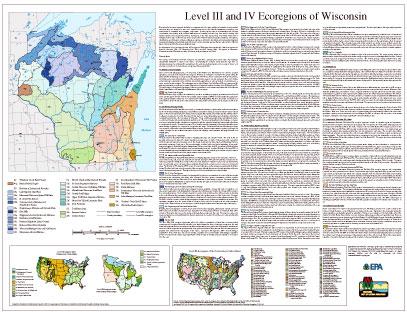
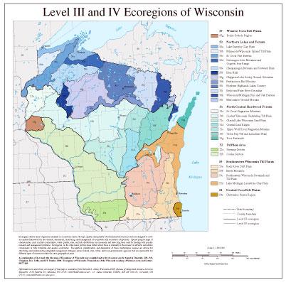
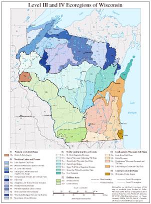
Ecoregions denote areas of general similarity in ecosystems and in the type, quality, and quantity of environmental resources; they are designed to serve as a spatial framework for the research, assessment, monitoring, and management of ecosystems and ecosystem components. Special purpose maps of characteristics such as plant communities, water quality, soils, and fish distributions are necessary and have long been used for dealing with specific research and management problems. Ecoregions, on the other hand, portray areas within which there is similarity in the mosaic of all biotic and abiotic components of both terrestrial and aquatic ecosystems. Recognition, identification, and delineation of these multipurpose regions are critical for structuring and implementing integrated management strategies across federal, state, tribal, and local governmental agencies that are responsible for different types of resources within the same geographical areas.
An explanation of how and why the map of Ecoregions of Wisconsin was compiled and a list of sources can be found in Omernik, J.M., S.S. Chapman, R.A. Lillie, and R.T. Dumke. 2000. Ecoregions of Wisconsin. Transactions of the Wisconsin Academy of Sciences, Arts, and Letters. 88:77-103
Information on electronic coverages of the map is available from Richard A. Lillie, Wisconsin DNR, Bureau of Integrated Science Services Research, 1350 Femrite Dr., Monona, WI 53716 email: lillir@dnr.state.wi.us; or James Omernik, USEPA, 200 SW 35th St., Corvallis, OR 97333 email: omernik.james@epa.gov.