Ecoregion Download Files by State - Region 6
Select a state for descriptive information about that state's Level III and IV ecoregions. Additionally, each state section contains links to downloadable maps in PDF format, and files containing GIS datasets (shapefiles, metadata, and symbology data).
Some Web content for Level IV Ecoregions is under construction. If you do not find a link to a state that has been completed, maps and GIS data are available on the Ecoregion FTP site and web content will be available shortly.
NOTE: maps and GIS files may differ. To make sure you are using the most current ecoregion data, download shapefiles of ecoregions.
- Arkansas
Arkansas
GIS Data (shapefiles, metadata and symbology)
- Arkansas Level III Shapefile (243 kb)
- Arkansas Level III Metadata and Arkansas Level III Symbology
- Arkansas Level IV Shapefile (951 kb)
- Arkansas Level IV Metadata and Arkansas Level IV Symbology
- Instructions for applying symbology to ecoregions
Maps (available in PDF format)
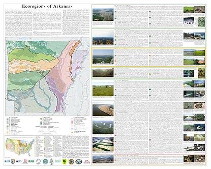
- Level IV Ecoregions of Arkansas--poster front side 45" X 36" (3 mb)
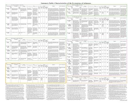
- Level IV Ecoregions of Arkansas--poster back side 46" X 36" (568 kb)
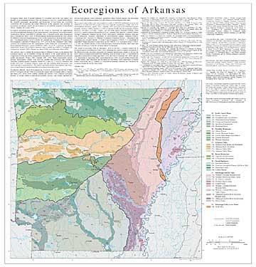
- Level III and IV Ecoregions of Arkansas--24" X 25" (832 kb)
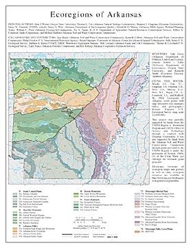
- Level III and IV Ecoregions of Arkansas--page size (852 kb)
Ecoregions denote areas of general similarity in ecosystems and in the type, quality, and quantity of environmental resources. They are designed to serve as a spatial framework for the research, assessment, management, and monitoring of ecosystems and ecosystem components. By recognizing the spatial differences in the capacities and potentials of ecosystems, ecoregions stratify the environment by its probable response to disturbance (Bryce, Omernik, and Larsen, 1999).
Ecoregions are general purpose regions that are critical for structuring and implementing ecosystem management strategies across federal agencies, state agencies, and nongovernment organizations that are responsible for different types of resources in the same geographical areas (Omernik and others, 2000). A Roman numeral hierarchical scheme has been adopted for different levels of ecological regions. Level I is the coarsest level, dividing North America into 15 ecological regions. Level II divides the continent into 52 regions (Commission for Environmental Cooperation Working Group, 1997). At level III, the continental United States contains 104 ecoregions and the conterminous United States has 84 ecoregions (U.S. Environmental Protection Agency [USEPA], 2003). Level IV ecoregions are further subdivisions of level III ecoregions. Explanations of the methods used to define the USEPA’s ecoregions are given in Omernik (1995), Omernik and others (2000), and Gallant and others (1989).
The approach used to compile the ecoregion map of Arkansas is based on the premise that ecological regions can be identified through the analysis of the spatial patterns and the composition of biotic and abiotic characteristics that affect or reflect differences in ecosystem quality and integrity (Wiken, 1986; Omernik, 1987, 1995). These characteristics include geology, physiography, climate, soils, land use, wildlife, fish, hydrology, and vegetation (including “potential natural vegetation” defined by Küchler (p. 2, 1964) as “vegetation that would exist today" if human influence ended and "the resulting plant succession" was "telescoped into a single moment”). The relative importance of each characteristic varies from one ecological region to another regardless of ecoregion hierarchical level.
In Arkansas, there are 7 level III ecoregions and 32 level IV ecoregions; all but four level IV ecoregions continue into ecologically similar parts of adjacent states (Chapman and others, 2002, 2004a, 2004b; Griffith, Omernik, and Azevedo, 1998). Arkansas’ ecological diversity is strongly related to regional physiography, geology, soil, climate, and land use. Elevated karst plateaus, folded mountains, agricultural valleys, forested uplands, and bottomland forests occur. Fire-maintained prairie was once extensive in several parts of the state.
The ecoregion map on this poster was compiled at a scale of 1:250,000, and depicts revisions and subdivisions of earlier level III ecoregions that were originally compiled at a smaller scale (U.S. Environmental Protection Agency, 2003; Omernik, 1987). It is part of a collaborative project primarily between USEPA Region 6, USEPA–National Health and Environmental Effects Research Laboratory (Corvallis, OR.), and the Multi-Agency Wetland Planning Team (MAWPT), which comprises representatives of six Arkansas state agencies (Arkansas Natural Heritage Commission, Arkansas Soil and Water Conservation Commission, Arkansas Game and Fish Commission, Arkansas Department of Environmental Quality, Arkansas Forestry Commission, and University of Arkansas Cooperative Extension Service). Collaboration and consultation also occurred with the U.S. Army Corps of Engineers (USACE), U.S. Department of Agriculture–Natural Resources Conservation Service (NRCS), U.S. Geologic Survey (USGS), U.S. Fish and Wildlife Service, USGS–Earth Resources Observation Systems Data Center, and University of Arkansas–Center for Advanced Spatial Technologies.
This project is associated with an interagency effort to develop a common framework of ecological regions (McMahon and others, 2001). Reaching that objective requires recognition of the differences in the conceptual approaches and mapping methodologies applied to develop the most common ecoregion-type frameworks, including those developed by the U.S. Department of Agriculture–Forest Service (Bailey and others, 1994), the USEPA (Omernik 1987, 1995), and the U.S. Department of Agriculture–Soil Conservation Service (1981). As each of these frameworks is further refined, their differences are becoming less discernible. Each collaborative ecoregion project, such as this one in Arkansas, is a step toward attaining consensus and consistency in ecoregion frameworks for the entire nation.
Literature Cited:
Bailey, R.G., Avers, P.E., King, T., and McNab, W.H., editors, 1994, Ecoregions and subregions of the United States (map): Washington, D.C., U.S. Department of Agriculture–Forest Service, map scale 1:7,500,000.
Bryce, S.A., Omernik, J.M., and Larsen, D.P., 1999, Ecoregions – a geographic framework to guide risk characterization and ecosystem management: Environmental Practice, v. 1, no. 3, p. 141-155.
Chapman, S.S., Griffith, G.E., Omernik, J.M., Comstock, J.A., Beiser, M.C., and Johnson, D., 2004a, Ecoregions of Mississippi (color poster with map, descriptive text, summary tables, and photographs): Reston, Virginia, U.S. Geological Survey, map scale 1:1,000,000.
Chapman, S.S., Kleiss, B.A., Omernik, J.M., Foti, T.L., and Murray, E.O., 2004b, Ecoregions of the Mississippi Alluvial Plain (color poster with map, descriptive text, summary tables, and photographs): Reston, Virginia, U.S. Geological Survey, map scale 1:1,150,000.
Chapman, S.S., Omernik, J.M., Griffith, G.E., Schroeder, W.A., Nigh, T.A., and Wilton, T.F., 2002, Ecoregions of Iowa and Missouri (color poster with map, descriptive text, summary tables, and photographs): Reston, Virginia, U.S. Geological Survey, map scale 1:1,800,000.
Commission for Environmental Cooperation Working Group, 1997, Ecological regions of North America – toward a common perspective: Montreal, Commission for Environmental Cooperation, 71 p.
Gallant, A.L., Whittier, T.R., Larsen, D.P., Omernik, J.M., and Hughes, R.M., 1989, Regionalization as a tool for managing environmental resources: Corvallis, Oregon, U.S. Environmental Protection Agency, EPA/600/3-89/060, 152 p.
Griffith, G., Omernik, J., and Azevedo, S., 1998, Ecoregions of Tennessee (color poster with map, descriptive text, summary tables, and photographs): Reston, U.S. Geological Survey, scale 1:940,000.
Küchler, A.W., 1964, Potential natural vegetation of the conterminous United States (map and manual): American Geographic Society, Special Publication 36, map scale 1:3,168,000.
McMahon, G., Gregonis, S.M., Waltman, S.W., Omernik, J.M., Thorson, T.D., Freeouf, J.A., Rorick, A.H., and Keys, J.E., 2001, Developing a spatial framework of common ecological regions for the conterminous United States: Environmental Management, v. 28, no. 3, p. 293-316.
Omernik, J.M., 1987, Ecoregions of the conterminous United States (map supplement): Annals of the Association of American Geographers, v. 77, p. 118-125, map scale 1:7,500,000.
Omernik, J.M., 1995, Ecoregions – a framework for environmental management, in Davis, W.S., and Simon, T.P., editors, Biological assessment and criteria – tools for water resource planning and decision making: Boca Raton, Florida, Lewis Publishers, p. 49-62.
Omernik, J.M., Chapman, S.S., Lillie, R.A., and Dumke, R.T., 2000, Ecoregions of Wisconsin: Transactions of the Wisconsin Academy of Sciences, Arts, and Letters, v. 88, p. 77-103.
U.S. Department of Agriculture–Soil Conservation Service, 1981, Land resource regions and major land resource areas of the United States: Agriculture Handbook 296, 156 p.
U.S. Environmental Protection Agency, 2003, Level III ecoregions of the continental United States (revision of Omernik, 1987): Corvallis, Oregon, USEPA–National Health and Environmental Effects Research Laboratory, Western Ecology Division, Map M-1, various scales.
Wiken, E., 1986, Terrestrial ecozones of Canada: Ottawa, Environment Canada, Ecological Land Classification Series no. 19, 26 p.
PRINCIPAL AUTHORS: Alan J. Woods (Oregon State University), Thomas L. Foti (Arkansas Natural Heritage Commission), Shannen S. Chapman (Dynamac Corporation), James M. Omernik (USEPA, retired), James A. Wise (Arkansas Department of Environmental Quality), Elizabeth O. Murray (Arkansas Multi-Agency Wetland Planning Team), William L. Prior (Arkansas Geological Commission), Joe B. Pagan, Jr. (U.S. Department of Agriculture–Natural Resources Conservation Service), Jeffrey A. Comstock (Indus Corporation), and Michael Radford (Arkansas Soil and Water Conservation Commission).
COLLABORATORS AND CONTRIBUTORS: Ken Brazil (Arkansas Soil and Water Conservation Commission), Kenneth Colbert (Arkansas Soil and Water Conservation Commission), Philip Crocker (U.S. Environmental Protection Agency), Brian Culpepper (University of Arkansas–Center for Advanced Spatial Technologies), Billy Justus (U.S. Geological Survey), Barbara A. Kleiss (USACE, ERDC–Waterways Experiment Station), Bob Leonard (Arkansas Game and Fish Commission), Thomas R. Loveland (U.S. Geological Survey), Larry Nance (Arkansas Forestry Commission), and Rex Roberg (Arkansas Cooperative Extension Service).
REVIEWERS: John Giese (Arkansas Department of Pollution Control and Ecology, retired), Robert J. Lillie (Professor, Department of Geosciences, Oregon State University), and Kenneth Smith (Executive Director, Audubon Arkansas).
CITING THIS POSTER: Woods A.J., Foti, T.L., Chapman, S.S., Omernik, J.M., Wise, J.A., Murray, E.O., Prior, W.L., Pagan, J.B., Jr., Comstock, J.A., and Radford, M., 2004, Ecoregions of Arkansas (color poster with map, descriptive text, summary tables, and photographs): Reston, Virginia, U.S. Geological Survey (map scale 1:1,000,000).
This project was partially supported by funds from the USEPA Region 6, Biocriteria Program and USEPA–Office of Science and Technology through a contract with Dynamac Corporation. It was also partially supported by funds from the Arkansas Soil and Water Conservation Commission through grants provided by the USEPA Region 6 under the provisions of Section 104(b) (3) of the Clean Water Act (through the wetlands grant program).
Mississippi Alluvial Plain
GIS Data (shapefiles, metadata and symbology)
- Mississippi Alluvial Plain Level III Shapefile (368 kb)
- Mississippi Alluvial Plain Level III Metadata
- Mississippi Alluvial Plain Level IV Shapefile (367 kb)
- Mississippi Alluvial Plain Level IV Metadata
Maps (available in PDF format)
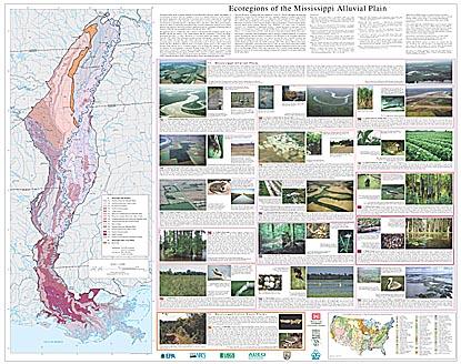
- Level IV Ecoregions of the Mississippi Alluvial Plain--poster front side 45" X 35.5" (14 mb)
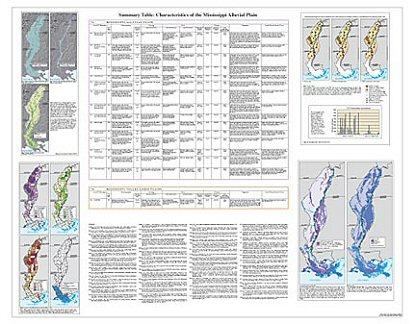
- Level IV Ecoregions of the Mississippi Alluvial Plain--poster back side 46" X 36" (2.6 mb)
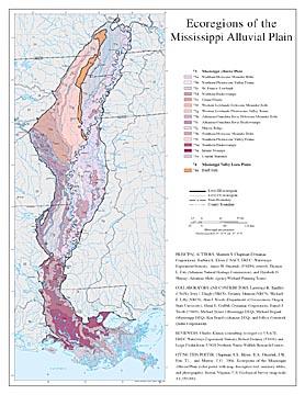
- Level III and IV Ecoregions of the Mississippi Alluvial Plain--22" X 37" (560 kb)
- Level III and IV Ecoregions of the Mississippi Alluvial Plain--page size (600 kb)
Ecoregions denote areas of general similarity in ecosystems and in the type, quality, and quantity of environmental resources; they are designed to serve as a spatial framework for the research, assessment, management, and monitoring of ecosystems and ecosystem components. By recognizing the spatial differences in the capacities and potentials of ecosystems, ecoregions stratify the environment by its probable response to disturbance (Bryce and others, 1999). These general purpose regions are critical for structuring and implementing ecosystem management strategies across federal agencies, state agencies, and non-government organizations that are responsible for different types of resources within the same geographical areas (Omernik and others, 2000).
The approach used to compile this map is based on the premise that ecological regions can be identified through the analysis of the spatial patterns and the composition of biotic and abiotic phenomena that affect or reflect differences in ecosystem quality and integrity (Wiken, 1986; Omernik, 1987, 1995). These phenomena include geology, physiography, vegetation, climate, soils, land use, wildlife, and hydrology. The relative importance of each characteristic varies from one ecological region to another regardless of the hierarchical level. A Roman numeral hierarchical scheme has been adopted for different levels of ecological regions. Level I is the coarsest level, dividing North America into 15 ecological regions. Level II divides the continent into 52 regions (Commission for Environmental Cooperation Working Group, 1997). At level III, the continental United States contains 104 ecoregions and the conterminous United States has 84 ecoregions (United States Environmental Protection Agency [USEPA], 2003). Level IV is a further subdivision of level III ecoregions. Explanations of the methods used to define the USEPA’s ecoregions are given in Omernik (1995), Omernik and others (2000), Griffith and others (1994), and Gallant and others (1989).
This level III and IV ecoregion map was compiled at a scale of 1:250,000 and depicts revisions and subdivisions of earlier level III ecoregions that were originally compiled at a smaller scale (USEPA 2003, Omernik, 1987). This poster is part of a collaborative effort primarily between USEPA Region VII, USEPA National Health and Environmental Effects Research Laboratory (Corvallis, Oregon), Mississippi Department of Environmental Quality, Arkansas Department of Environmental Quality, Arkansas Multi-Agency Wetland Planning Team (MAWPT), U.S. Army Corps of Engineers (USACE), U.S. Department of Agriculture (USDA) - Natural Resources Conservation Service (NRCS), U.S. Department of Interior - Fish and Wildlife Service (USFWS), and U.S. Department of Interior - U.S. Geological Survey (USGS) - Earth Resources Observation Systems (EROS) Data Center.
This project is associated with an interagency effort to develop a common framework of ecological regions. Reaching that objective requires recognition of the differences in the conceptual approaches and mapping methodologies that have been used to develop the most common ecoregion-type frameworks, including those developed by the U.S. Department of Agriculture - Forest Service (USFS) (Bailey and others, 1994), the US EPA (Omernik, 1987, 1995), and the NRCS (United States Department of Agriculture - Soil Conservation Service, 1981). As each of these frameworks is further refined, their differences are becoming less discernible. Regional collaborative projects such as this one in the Mississippi Alluvial Plain, where agreement can be reached among multiple resource management agencies, are a step toward attaining consensus and consistency in ecoregion frameworks for the entire nation.
Literature Cited:
Bailey, R.G., Avers, P.E., King, T., and McNab, W.H., eds., 1994, Ecoregions and subregions of the United States (map) (supplementary table of map unit descriptions compiled and edited by McNab, W.H., and Bailey, R.G.): Washington, D.C., U.S. Department of Agriculture - Forest Service, scale 1:7,500,000.
Bryce, S.A., Omernik, J.M., and Larsen, D.P., 1999, Ecoregions - a geographic framework to guide risk characterization and ecosystem management: Environmental Practice v. 1, no. 3, p. 141-155.
Bryce, S.A., Omernik, J.M., Pater, D.E., Ulmer, M., Schaar, J., Freeouf, J.A., Johnson, R., Kuck, P., and Azevedo, S.H., 1998, Ecoregions of North Dakota and South Dakota (color poster with map, descriptive text, summary tables, and photographs): Reston, Virginia, U.S. Geological Survey (map scale 1:1,500,000).
Commission for Environmental Cooperation Working Group, 1997, Ecological regions of North America - toward a common perspective: Montreal, Quebec, Commission for Environmental Cooperation, 71 p.
Gallant, A.L., Whittier, T.R., Larsen, D.P., Omernik, J.M., and Hughes, R.M., 1989, Regionalization as a tool for managing environmental resources: Corvallis, Oregon, U.S. Environmental Protection Agency, EPA/600/3-89/060, 152 p.
Griffith, G.E., Omernik, J.M., Wilton, T.F., and Pierson, S.M., 1994, Ecoregions and subregions of Iowa - a framework for water quality assessment and management: The Journal of the Iowa Academy of Science, v. 101, no. 1, p. 5-13.
McMahon, G., Gregonis, S.M., Waltman, S.W., Omernik, J.M., Thorson, T.D., Freeouf, J.A., Rorick, A.H., and J.E., Keys, 2001, Developing a spatial framework of common ecological regions for the conterminous United States, Environmental Management, v. 28, no. 3, p. 293-346.
Omernik, J.M., 1987, Ecoregions of the conterminous United States (map supplement): Annals of the Association of American Geographers, v. 77, no. 1, p. 118-125, scale 1:7,500,000.
Omernik, J.M., 1995, Ecoregions - a framework for environmental management, in Davis, W.S., and Simon, T.P., eds., Biological assessment and criteria - tools for water resource planning and decision making: Boca Raton, Florida, Lewis Publishers, p. 49-62.
Omernik, J.M., Chapman, S.S., Lillie, R.A., and Dumke, R.T., 2000, Ecoregions of Wisconsin: Transactions of the Wisconsin Academy of Sciences, Arts, and Letters, v. 88, p. 77-103.
U.S. Department of Agriculture - Soil Conservation Service, 1981, Land resource regions and major land resource areas of the United States: Agriculture Handbook 296, 156 p.
U.S. Environmental Protection Agency, 2003, Level III ecoregions of the continental United States (revision of Omernik, 1987): Corvallis, Oregon, U.S. Environmental Protection Agency - National Health and Environmental Effects Research Laboratory, Map M-1, various scales.
Wiken, E., 1986, Terrestrial ecozones of Canada: Ottawa, Environment Canada, Ecological Land Classification Series no. 19, 26 p.
PRINCIPAL AUTHORS: Shannen S. Chapman (Dynamac Corporation), Barbara A. Kleiss (USACE, ERDC -Waterways Experiment Station), James M. Omernik, (USEPA, retired), Thomas L. Foti (Arkansas Natural Heritage Commission), and Elizabeth O. Murray (Arkansas Multi-Agency Wetland Planning Team).
COLLABORATORS AND CONTRIBUTORS: Lawrence R. Handley (USGS), Jerry J. Daigle (NRCS), Delaney Johnson (NRCS), Michael E. Lilly (NRCS), Alan J. Woods (Department of Geosciences, Oregon State University), Glenn E. Griffith (Dynamac Corporation), Daniel J. Twedt (USGS), Michael Beiser (Mississippi DEQ), Michael Bograd (Mississippi DEQ), Ken Brazil (Arkansas DEQ), and Jeffrey Comstock (Indus Corporation).
REVIEWERS: Charles Klimas (consulting ecologist c/o USACE, ERDC-Waterways Experiment Station), Robert Delaney (USGS), and Leigh Fredrickson (USGS Northern Prairie Wildlife Research Center).
CITING THIS POSTER: Chapman, S.S., Kleiss, B.A., Omernik, J.M., Foti, T.L., and Murray, E.O., 2004, Ecoregions of the Mississippi Alluvial Plain (color poster with map, descriptive text, summary tables, and photographs): Reston, Virginia, U.S. Geological Survey (map scale 1:1,150,000).
This project was partially supported by funds from the USEPA Region 6, Biocriteria Program and USEPA - Office of Science and Technology through a contract with Dynamac Corporation.
- Louisiana
Louisiana
GIS Data (shapefiles, metadata and symbology)
- Louisiana Level III Shapefile (1.36 mb)
- Louisiana Level III Metadata and Louisiana Level III Symbology
- Louisiana Level IV Shapefile (2.19 mb)
- Louisiana Level IV Metadata and Louisiana Level IV Symbology
- Instructions for applying symbology to ecoregions
Maps (available in PDF format)
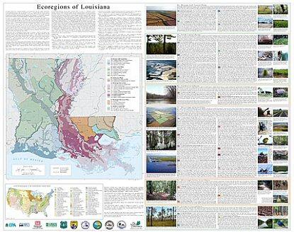
- Level IV Ecoregions of Louisiana--poster front side 48" X 36" (15 mb)
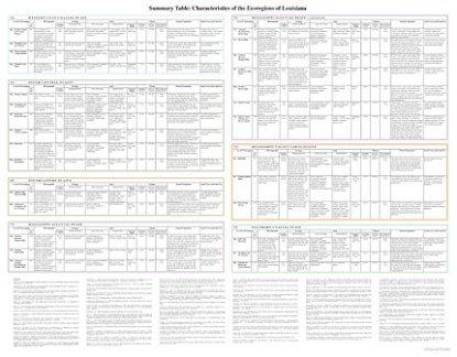
- Summary Table: Characteristics of the Ecoregions of Louisiana-- poster back side 46 X 36" (338 kb)
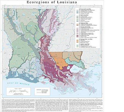
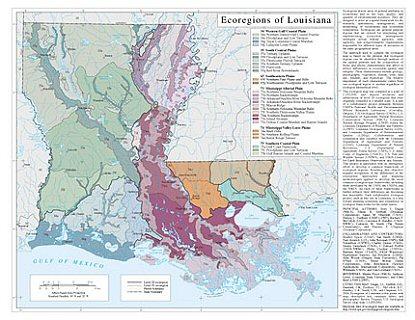
- Level III and IV Ecoregions of Louisiana- map 23 X 24" (1.4 mb)
- Level III and IV Ecoregions of Louisiana- page sized map 11 X 8.5" ( 1.8 mb)
Ecoregions denote areas of general similarity in ecosystems and in the type, quality, and quantity of environmental resources; they are designed to serve as a spatial framework for the research, assessment, management, and monitoring of ecosystems and ecosystem components. By recognizing the spatial differences in the capacities and potentials of ecosystems, ecoregions stratify the environment by its probable response to disturbance (Bryce and others, 1999). These general purpose regions are critical for structuring and implementing ecosystem management strategies across federal agencies, state agencies, and nongovernment organizations that are responsible for different types of resources within the same geographical areas (Omernik and others, 2000).
The approach used to compile this map is based on the premise that ecological regions can be identified through the analysis of the spatial patterns and the composition of biotic and abiotic phenomena that affect or reflect differences in ecosystem quality and integrity (Wiken, 1986; Omernik, 1987, 1995). These phenomena include geology, physiography, vegetation, climate, soils, land use, wildlife, and hydrology.
The relative importance of each characteristic varies from one ecological region to another regardless of the hierarchical level. A Roman numeral hierarchical scheme has been adopted for different levels of ecological regions. Level I is the coarsest level, dividing North America into 15 ecological regions. Level II divides the continent into 52 regions (Commission for Environmental Cooperation Working Group, 1997). At level III, the continental United States contains 104 ecoregions and the conterminous United States has 84 ecoregions (United States Environmental Protection Agency [USEPA], 2003). Level IV is a further subdivision of level III ecoregions. Explanations of the methods used to define the USEPA’s ecoregions are given in Omernik (1995), Omernik and others (2000), Griffith and others (1994), and Gallant and others (1989).
The approach used to compile the ecoregion map of Louisiana is based on the premise that ecological regions can be identified through the analysis of the spatial patterns and the composition of biotic and abiotic characteristics that affect or reflect differences in ecosystem quality and integrity (Wiken, 1986; Omernik, 1987, 1995). These characteristics include geology, physiography, vegetation, climate, soils, land use, wildlife, and hydrology. The relative importance of each characteristic varies from one ecological region to another regardless of ecoregion hierarchical level.
Louisiana contains barrier islands and coastal lowlands, large river floodplains, rolling and hilly coastal plains with evergreen and deciduous forests, and a variety of aquatic habitats. There are 6 level III ecoregions and 28 level IV ecoregions, and most of these continue into ecologically similar parts of adjacent states (Chapman and others, 2004; Griffith and others, 2004; Woods and others, 2004). The ecoregion map on this poster was compiled at a scale of 1:250,000, and depicts revisions and subdivisions of earlier level III ecoregions that were originally compiled at a smaller scale (U.S. Environmental Protection Agency, 2006; Omernik, 1987). It is part of a collaborative project primarily between USEPA–National Health and Environmental Effects Research Laboratory (Corvallis, Oregon), U.S. Geological Survey (USGS), U.S. Department of Agriculture–Natural Resources Conservation Service (NRCS), Louisiana Natural Heritage Program (LNHP) within the Louisiana Department of Wildlife and Fisheries (LDWF), Louisiana Geological Survey (LGS), and Louisiana Department of Environmental Quality (LDEQ). Collaboration and consultation also occurred with the Louisiana Department of Agriculture and Forestry (LDAF), Louisiana Department of Natural Resources, U.S. Department of Agriculture–Forest Service (USFS), U.S. Army Corps of Engineers (USACE), U.S. Fish and Wildlife Service (USFWS), and USGS–Center for Earth Resources Observation and Science. This project is associated with an interagency effort to develop a common framework of ecological regions (McMahon and others, 2001). Reaching that objective requires recognition of the differences in the conceptual approaches and mapping methodologies applied to develop the most common ecoregion-type frameworks, including those developed by the USFS (Bailey and others, 1994), the USEPA (Omernik 1987, 1995), and the U.S. Department of Agriculture–Soil Conservation Service (1981). As each of these frameworks is further refined, their differences are becoming less discernible. Each collaborative ecoregion project, such as this one in Louisiana, is a step toward attaining consensus and consistency in ecoregion frameworks for the entire nation.
Literature Cited:
Bailey, R.G., Avers, P.E., King, T., and McNab, W.H., editors, 1994, Ecoregions and subregions of the United States (map): Washington, D.C., U.S. Department of Agriculture–Forest Service, map scale 1:7,500,000.
Bryce, S.A., Omernik, J.M., and Larsen, D.P., 1999, Ecoregions – a geographic framework to guide risk characterization and ecosystem management: Environmental Practice, v. 1, no. 3, p. 141-155.
Chapman, S.S., Griffith, G.E., Omernik, J.M., Comstock, J.A., Beiser, M.C., and Johnson, D., 2004, Ecoregions of Mississippi (2 sided color poster with map, descriptive text, summary tables, and photographs): Reston, Virginia, U.S. Geological Survey, map scale 1:1,000,000.
Chapman, S.S., Kleiss, B.A., Omernik, J.M., Foti, T.L., and Murray, E.O., 2004, Ecoregions of the Mississippi Alluvial Plain (color poster with map, descriptive text, summary tables, and photographs): Reston, Virginia, U.S. Geological Survey, map scale 1:1,150,000.
Commission for Environmental Cooperation Working Group, 1997, Ecological regions of North America – toward a common perspective: Montreal, Commission for Environmental Cooperation, 71 p.
Gallant, A.L., Whittier, T.R., Larsen, D.P., Omernik, J.M., and Hughes, R.M., 1989, Regionalization as a tool for managing environmental resources: Corvallis, Oregon, U.S. Environmental Protection Agency, EPA/600/3-89/060, 152 p.
Griffith, G.E., Bryce, S.A., Omernik, J.M., Comstock, J.A., Rogers, A.C., Harrison, B., Greenwade, J., Casby-Horton, S., Hatch, S.L., and Bezanson, D., 2004, Ecoregions of Texas (color poster with map, descriptive text, and photographs): Reston, Virginia, U.S. Geological Survey, map scale 1:2,500,000.
McMahon, G., Gregonis, S.M., Waltman, S.W., Omernik, J.M., Thorson, T.D., Freeouf, J.A., Rorick, A.H., and Keys, J.E., 2001, Developing a spatial framework of common ecological regions for the conterminous United States: Environmental Management, v. 28, no. 3, p. 293-316.
Omernik, J.M., 1987, Ecoregions of the conterminous United States (map supplement): Annals of the Association of American Geographers, v. 77, p. 118-125, map scale 1:7,500,000.
Omernik, J.M., 1995, Ecoregions – a framework for environmental management, in Davis, W.S., and Simon, T.P., editors, Biological assessment and criteria – tools for water resource planning and decision making: Boca Raton, Florida, Lewis Publishers, p. 49-62.
Omernik, J.M., 2004, Perspectives on the nature and definition of ecological regions: Environmental Management, v. 34, Supplement 1, p. s27-s38.
Omernik, J.M., Chapman, S.S., Lillie, R.A., and Dumke, R.T., 2000, Ecoregions of Wisconsin: Transactions of the Wisconsin Academy of Sciences, Arts, and Letters, v. 88, p. 77-103.
U.S. Department of Agriculture–Soil Conservation Service, 1981, Land resource regions and major land resource areas of the United States: Agriculture Handbook 296, 156 p. + map.
U.S. Environmental Protection Agency, 2006, Level III ecoregions of the continental United States (revision of Omernik, 1987): Corvallis, Oregon, USEPA–National Health and Environmental Effects Research Laboratory, Map M-1, various scales.
Wiken, E., 1986, Terrestrial ecozones of Canada: Ottawa, Environment Canada, Ecological Land Classification Series no. 19, 26 p.
Woods, A.J., Foti, T.L., Chapman, S.S., Omernik, J.M., Wise, J.A., Murray, E.O., Prior, W.L., Pagan, J.B., Jr., Comstock, J.A., and Radford, M., 2004, Ecoregions of Arkansas (color poster with map, descriptive text, summary tables, and photographs): Reston, Virginia, U.S. Geological Survey, map scale 1:1,000,000.
PRINCIPAL AUTHORS: Jerry J. Daigle (NRCS), Glenn E. Griffith (Dynamac Corporation), James M. Omernik (USGS), Patricia L. Faulkner (LNHP-LDWF), Richard P. McCulloh (LGS), Lawrence R. Handley (USGS-National Wetlands Research Center [NWRC]), Latimore M. Smith (The Nature Conservancy), and Shannen S. Chapman (Dynamac Corporation).
COLLABORATORS AND CONTRIBUTORS: Bradley Spicer (LDAF), Sue Smith (LDEQ), Paul Heinrich (LGS), John Novosad (USFS), Bill Vermillion (USFWS), Charles Demas (USGS), Dennis Demcheck (USGS), C. Edward Proffitt (USGS-NWRC), Philip Crocker (USEPA), Barbara Kleiss (USACE, ERDC-Waterways Experiment Station), Jan Boydston (LDEQ), Alan Woods (Oregon State University), Pat O'Neil (USGS), Brian Moran (Indus Corporation), John Hutchinson (Science Applications International Corporation), Jack Wittmann (USGS), and Tom Loveland (USGS).
Mississippi Alluvial Plain
GIS Data (shapefiles, metadata and symbology)
- Mississippi Alluvial Plain Level III Shapefile (368 kb)
- Mississippi Alluvial Plain Level III Metadata
- Mississippi Alluvial Plain Level IV Shapefile (367 kb)
- Mississippi Alluvial Plain Level IV Metadata
Maps (available in PDF format)
- Level IV Ecoregions of the Mississippi Alluvial Plain--poster front side 45" X 35.5" (14 mb)
- Level IV Ecoregions of the Mississippi Alluvial Plain--poster back side 46" X 36" (2.6 mb)
- Level III and IV Ecoregions of the Mississippi Alluvial Plain--22" X 37" (560 kb)
- Level III and IV Ecoregions of the Mississippi Alluvial Plain--page size (600 kb)
Ecoregions denote areas of general similarity in ecosystems and in the type, quality, and quantity of environmental resources; they are designed to serve as a spatial framework for the research, assessment, management, and monitoring of ecosystems and ecosystem components. By recognizing the spatial differences in the capacities and potentials of ecosystems, ecoregions stratify the environment by its probable response to disturbance (Bryce and others, 1999). These general purpose regions are critical for structuring and implementing ecosystem management strategies across federal agencies, state agencies, and non-government organizations that are responsible for different types of resources within the same geographical areas (Omernik and others, 2000).
The approach used to compile this map is based on the premise that ecological regions can be identified through the analysis of the spatial patterns and the composition of biotic and abiotic phenomena that affect or reflect differences in ecosystem quality and integrity (Wiken, 1986; Omernik, 1987, 1995). These phenomena include geology, physiography, vegetation, climate, soils, land use, wildlife, and hydrology. The relative importance of each characteristic varies from one ecological region to another regardless of the hierarchical level. A Roman numeral hierarchical scheme has been adopted for different levels of ecological regions. Level I is the coarsest level, dividing North America into 15 ecological regions. Level II divides the continent into 52 regions (Commission for Environmental Cooperation Working Group, 1997). At level III, the continental United States contains 104 ecoregions and the conterminous United States has 84 ecoregions (United States Environmental Protection Agency [USEPA], 2003). Level IV is a further subdivision of level III ecoregions. Explanations of the methods used to define the USEPA’s ecoregions are given in Omernik (1995), Omernik and others (2000), Griffith and others (1994), and Gallant and others (1989).
This level III and IV ecoregion map was compiled at a scale of 1:250,000 and depicts revisions and subdivisions of earlier level III ecoregions that were originally compiled at a smaller scale (USEPA 2003, Omernik, 1987). This poster is part of a collaborative effort primarily between USEPA Region VII, USEPA National Health and Environmental Effects Research Laboratory (Corvallis, Oregon), Mississippi Department of Environmental Quality, Arkansas Department of Environmental Quality, Arkansas Multi-Agency Wetland Planning Team (MAWPT), U.S. Army Corps of Engineers (USACE), U.S. Department of Agriculture (USDA) - Natural Resources Conservation Service (NRCS), U.S. Department of Interior - Fish and Wildlife Service (USFWS), and U.S. Department of Interior - U.S. Geological Survey (USGS) - Earth Resources Observation Systems (EROS) Data Center.
This project is associated with an interagency effort to develop a common framework of ecological regions. Reaching that objective requires recognition of the differences in the conceptual approaches and mapping methodologies that have been used to develop the most common ecoregion-type frameworks, including those developed by the U.S. Department of Agriculture - Forest Service (USFS) (Bailey and others, 1994), the US EPA (Omernik, 1987, 1995), and the NRCS (United States Department of Agriculture - Soil Conservation Service, 1981). As each of these frameworks is further refined, their differences are becoming less discernible. Regional collaborative projects such as this one in the Mississippi Alluvial Plain, where agreement can be reached among multiple resource management agencies, are a step toward attaining consensus and consistency in ecoregion frameworks for the entire nation.
Literature Cited:
Bailey, R.G., Avers, P.E., King, T., and McNab, W.H., eds., 1994, Ecoregions and subregions of the United States (map) (supplementary table of map unit descriptions compiled and edited by McNab, W.H., and Bailey, R.G.): Washington, D.C., U.S. Department of Agriculture - Forest Service, scale 1:7,500,000.
Bryce, S.A., Omernik, J.M., and Larsen, D.P., 1999, Ecoregions - a geographic framework to guide risk characterization and ecosystem management: Environmental Practice v. 1, no. 3, p. 141-155.
Bryce, S.A., Omernik, J.M., Pater, D.E., Ulmer, M., Schaar, J., Freeouf, J.A., Johnson, R., Kuck, P., and Azevedo, S.H., 1998, Ecoregions of North Dakota and South Dakota (color poster with map, descriptive text, summary tables, and photographs): Reston, Virginia, U.S. Geological Survey (map scale 1:1,500,000).
Commission for Environmental Cooperation Working Group, 1997, Ecological regions of North America - toward a common perspective: Montreal, Quebec, Commission for Environmental Cooperation, 71 p.
Gallant, A.L., Whittier, T.R., Larsen, D.P., Omernik, J.M., and Hughes, R.M., 1989, Regionalization as a tool for managing environmental resources: Corvallis, Oregon, U.S. Environmental Protection Agency, EPA/600/3-89/060, 152 p.
Griffith, G.E., Omernik, J.M., Wilton, T.F., and Pierson, S.M., 1994, Ecoregions and subregions of Iowa - a framework for water quality assessment and management: The Journal of the Iowa Academy of Science, v. 101, no. 1, p. 5-13.
McMahon, G., Gregonis, S.M., Waltman, S.W., Omernik, J.M., Thorson, T.D., Freeouf, J.A., Rorick, A.H., and J.E., Keys, 2001, Developing a spatial framework of common ecological regions for the conterminous United States, Environmental Management, v. 28, no. 3, p. 293-346.
Omernik, J.M., 1987, Ecoregions of the conterminous United States (map supplement): Annals of the Association of American Geographers, v. 77, no. 1, p. 118-125, scale 1:7,500,000.
Omernik, J.M., 1995, Ecoregions - a framework for environmental management, in Davis, W.S., and Simon, T.P., eds., Biological assessment and criteria - tools for water resource planning and decision making: Boca Raton, Florida, Lewis Publishers, p. 49-62.
Omernik, J.M., Chapman, S.S., Lillie, R.A., and Dumke, R.T., 2000, Ecoregions of Wisconsin: Transactions of the Wisconsin Academy of Sciences, Arts, and Letters, v. 88, p. 77-103.
U.S. Department of Agriculture - Soil Conservation Service, 1981, Land resource regions and major land resource areas of the United States: Agriculture Handbook 296, 156 p.
U.S. Environmental Protection Agency, 2003, Level III ecoregions of the continental United States (revision of Omernik, 1987): Corvallis, Oregon, U.S. Environmental Protection Agency - National Health and Environmental Effects Research Laboratory, Map M-1, various scales.
Wiken, E., 1986, Terrestrial ecozones of Canada: Ottawa, Environment Canada, Ecological Land Classification Series no. 19, 26 p.
PRINCIPAL AUTHORS: Shannen S. Chapman (Dynamac Corporation), Barbara A. Kleiss (USACE, ERDC -Waterways Experiment Station), James M. Omernik, (USEPA, retired), Thomas L. Foti (Arkansas Natural Heritage Commission), and Elizabeth O. Murray (Arkansas Multi-Agency Wetland Planning Team).
COLLABORATORS AND CONTRIBUTORS: Lawrence R. Handley (USGS), Jerry J. Daigle (NRCS), Delaney Johnson (NRCS), Michael E. Lilly (NRCS), Alan J. Woods (Department of Geosciences, Oregon State University), Glenn E. Griffith (Dynamac Corporation), Daniel J. Twedt (USGS), Michael Beiser (Mississippi DEQ), Michael Bograd (Mississippi DEQ), Ken Brazil (Arkansas DEQ), and Jeffrey Comstock (Indus Corporation).
REVIEWERS: Charles Klimas (consulting ecologist c/o USACE, ERDC-Waterways Experiment Station), Robert Delaney (USGS), and Leigh Fredrickson (USGS Northern Prairie Wildlife Research Center).
CITING THIS POSTER: Chapman, S.S., Kleiss, B.A., Omernik, J.M., Foti, T.L., and Murray, E.O., 2004, Ecoregions of the Mississippi Alluvial Plain (color poster with map, descriptive text, summary tables, and photographs): Reston, Virginia, U.S. Geological Survey (map scale 1:1,150,000).
This project was partially supported by funds from the USEPA Region 6, Biocriteria Program and USEPA - Office of Science and Technology through a contract with Dynamac Corporation.
- New Mexico
GIS Data (shapefiles, metadata and symbology)
- New Mexico Level III Shapefile (1.01 mb)
- New Mexico Level III Metadata and New Mexico Level III Symbology
- New Mexico Level IV Shapefile (3.5 mb)
- New Mexico Level IV Metadata and New Mexico Level IV Symbology
- Instructions for applying symbology to ecoregions
Maps (available in PDF format)
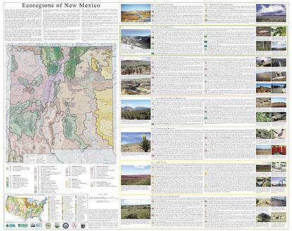
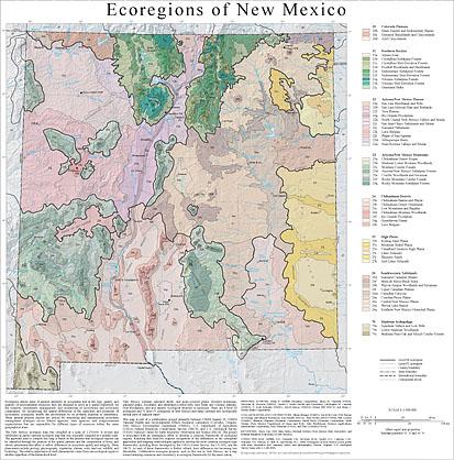
- Level III and IV Ecoregions of New Mexico-- poster front side 45 X 35" (24 mb)
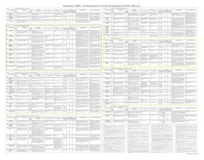
- Summary Table: Characteristics of the Ecoregions of New Mexico-- poster back side 46 X 36" (480 kb)
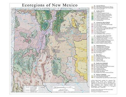
- Level III and IV Ecoregions of New Mexico- map 24 X 24" ( 3.1 mb)
- Level III and IV Ecoregions of New Mexico- page sized map 11 X 8.5" ( 2.2 mb)
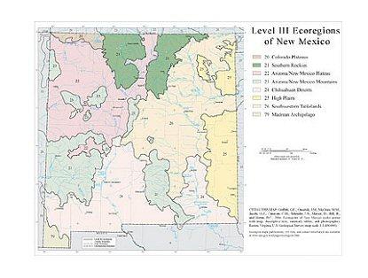
- Level III Ecoregions of New Mexico- page sized map 11 X 8.5" ( 1.3 mb)
Ecoregions denote areas of general similarity in ecosystems and in the type, quality, and quantity of environmental resources; they are designed to serve as a spatial framework for the research, assessment, management, and monitoring of ecosystems and ecosystem components. By recognizing the spatial differences in the capacities and potentials of ecosystems, ecoregions stratify the environment by its probable response to disturbance (Bryce and others, 1999). These general purpose regions are critical for structuring and implementing ecosystem management strategies across federal agencies, state agencies, and nongovernment organizations that are responsible for different types of resources within the same geographical areas (Omernik and others, 2000).
The approach used to compile this map is based on the premise that ecological regions can be identified through the analysis of the spatial patterns and the composition of biotic and abiotic phenomena that affect or reflect differences in ecosystem quality and integrity (Wiken, 1986; Omernik, 1987, 1995). These phenomena include geology, physiography, vegetation, climate, soils, land use, wildlife, and hydrology.
The relative importance of each characteristic varies from one ecological region to another regardless of the hierarchical level. A Roman numeral hierarchical scheme has been adopted for different levels of ecological regions. Level I is the coarsest level, dividing North America into 15 ecological regions. Level II divides the continent into 52 regions (Commission for Environmental Cooperation Working Group, 1997). At level III, the continental United States contains 104 ecoregions and the conterminous United States has 84 ecoregions (United States Environmental Protection Agency [USEPA], 2003). Level IV is a further subdivision of level III ecoregions. Explanations of the methods used to define the USEPA’s ecoregions are given in Omernik (1995), Omernik and others (2000), Griffith and others (1994), and Gallant and others (1989).
New Mexico contains semiarid shrub- and grass-covered plains, forested mountains, glaciated peaks, woodland- and shrubland-covered hills, lava fields and volcanic plateaus, river floodplains, and arid deserts. Ecological diversity is enormous. There are 8 level III ecoregions and 55 level IV ecoregions in New Mexico and many continue into ecologically similar parts of adjacent states (Griffith and others, 2004; Woods and others, 2005; Chapman and others, 2006).
This poster is part of a collaborative project primarily between USEPA Region VI, USEPA National Health and Environmental Effects Research Laboratory (Corvallis, Oregon), New Mexico Environment Department (NMED), U.S. Department of Agriculture (USDA)–Natural Resources Conservation Service (NRCS), and U.S. Geological Survey (USGS)–National Center for Earth Resources Observation and Science (EROS). The project is associated with an interagency effort to develop a common framework of ecological regions (McMahon and others, 2001). Reaching that objective requires recognition of the differences in the conceptual approaches and mapping methodologies applied to develop the most common ecoregion-type frameworks, including those developed by the USDA–Forest Service (Bailey and others, 1994), the USEPA (Omernik, 1987, 1995), and the NRCS (U.S. Department of Agriculture–Soil Conservation Service, 1981). As each of these frameworks is further refined, their differences are becoming less discernible. Collaborative ecoregion projects, such as this one in New Mexico, are a step toward attaining consensus and consistency in ecoregion frameworks for the entire nation.
Literature Cited:
Bailey, R.G., Avers, P.E., King, T., and McNab, W.H., eds., 1994, Ecoregions and subregions of the United States (map) (supplementary table of map unit descriptions compiled and edited by McNab, W.H. and Bailey, R.G.): Washington, D.C., USDA–Forest Service, scale 1:7,500,000.
Bryce, S.A., Omernik, J.M., and Larsen, D.P., 1999, Ecoregions – a geographic framework to guide risk characterization and ecosystem management: Environmental Practice, v. 1, no. 3, p. 141-155.
Chapman, S.S., Griffith, G.E., Omernik, J.M., Price, A.B., Freeouf, J., and Schrupp, D.L., 2006, Ecoregions of Colorado: Reston, Virginia, U.S. Geological Survey, map scale 1:1,200,000.
Commission for Environmental Cooperation Working Group, 1997, Ecological regions of North America – toward a common perspective: Montreal, Commission for Environmental Cooperation, 71 p.
Gallant, A.L., Whittier, T.R., Larsen, D.P., Omernik, J.M., and Hughes, R.M., 1989, Regionalization as a tool for managing environmental resources: Corvallis, Oregon, U.S. Environmental Protection Agency, EPA/600/3-89/060, 152 p.
Griffith, G.E., Bryce, S.A., Omernik, J.M., Comstock, J.A., Rogers, A.C., Harrison, B., Greenwade, J., Casby-Horton, S., Hatch, S.L., and Bezanson, D., 2004, Ecoregions of Texas: Reston, Virginia, U.S. Geological Survey, map scale 1:2,500,000.
McMahon, G., Gregonis, S.M., Waltman, S.W., Omernik, J.M., Thorson, T.D., Freeouf, J.A., Rorick, A.H., and Keys, J.E., 2001, Developing a spatial framework of common ecological regions for the conterminous United States: Environmental Management, v. 28, no. 3, p. 293-316.
Omernik, J.M., 1987, Ecoregions of the conterminous United States (map supplement): Annals of the Association of American Geographers, v. 77, no. 1, p. 118-125, scale 1:7,500,000.
Omernik, J.M., 1995, Ecoregions – a framework for environmental management, in Davis, W.S. and Simon, T.P., eds., Biological assessment and criteria-tools for water resource planning and decision making: Boca Raton, Florida, Lewis Publishers, p. 49-62.
Omernik, J.M., 2004, Perspectives on the nature and definition of ecological regions: Environmental Management, v. 34, Supplement 1, p. s27-s38.
Omernik, J.M., Chapman, S.S., Lillie, R.A., and Dumke, R.T., 2000, Ecoregions of Wisconsin: Transactions of the Wisconsin Academy of Sciences, Arts, and Letters, v. 88, p. 77-103.
U.S. Department of Agriculture–Soil Conservation Service, 1981, Land resource regions and major land resource areas of the United States: Agriculture Handbook 296, 156 p.
U.S. Environmental Protection Agency, 2006, Level III ecoregions of the continental United States (revision of Omernik, 1987): Corvallis, Oregon, USEPA – National Health and Environmental Effects Research Laboratory, Map M-1, various scales.
Wiken, E., 1986, Terrestrial ecozones of Canada: Ottawa, Environment Canada, Ecological Land Classification Series no. 19, 26 p.
Woods, A.J., Omernik, J.M., Butler, D.R., Ford, J.G., Henley, J.E., Hoagland, B.W., Arndt, D.S., and Moran, B.C., 2005, Ecoregions of Oklahoma: Reston, Virginia, U.S. Geological Survey, map scale 1:1,250,000.
PRINCIPAL AUTHORS: Glenn E. Griffith (Dynamac Corporation), James M. Omernik (USGS), Maryann M. McGraw (NMED), Gerald Z. Jacobi (Jacobi and Associates), Christopher M. Canavan (NMED), T. Scott Schrader (NMSU), David Mercer (NMED), Robert Hill (NRCS), and Brian C. Moran (Indus Corporation).
COLLABORATORS AND CONTRIBUTORS: Shann Stringer (NMED), David McCraw (NM Bureau of Geology and Mineral Resources), Ken Scheffe (NRCS), Paul Neville (EDAC/UNM), Phil Crocker (USEPA), Shannen Chapman (Dynamac Corporation), Sandy Bryce (Dynamac Corporation), Mark Gruber (New Mexico Department of Game and Fish), John Hutchinson (Science Applications International Corporation), Jack Wittmann (USGS), and Tom Loveland (USGS).
- Oklahoma
GIS Data (shapefiles, metadata and symbology)
- Oklahoma Level III Shapefile (463 kb)
- Oklahoma Level III Metadata and Oklahoma Level III Symbology
- Oklahoma Level IV Shapefile (865 kb)
- Oklahoma Level IV Metadata and Oklahoma Level IV Symbology
- Instructions for applying symbology to ecoregions
Maps (available in PDF format)
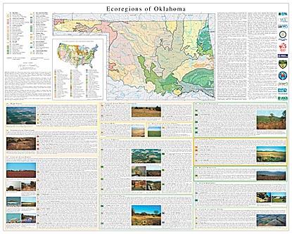
- Level IV Ecoregions of Oklahoma--poster front side 44.5" X 36" (16 mb)
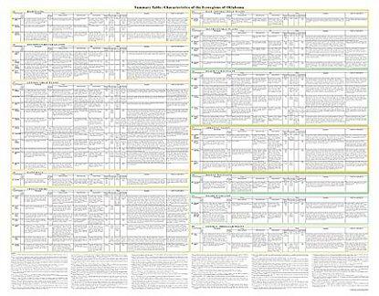
- Level IV Ecoregions of Oklahoma--poster back side 46" X 36" (130 kb)
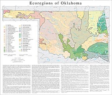
- Level III and IV Ecoregions of Oklahoma--26" X 22" (892 kb)
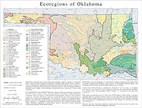
- Level III and IV Ecoregions of Oklahoma--page size (953 kb)
Ecoregions denote areas of general similarity in ecosystems and in the type, quality, and quantity of environmental resources. They are designed to serve as a spatial framework for the research, assessment, management, and monitoring of ecosystems and ecosystem components. By recognizing the spatial differences in the capacities and potentials of ecosystems, ecoregions stratify the environment by its probable response to disturbance (Bryce, Omernik, and Larsen, 1999).
Ecoregions are general purpose regions that are critical for structuring and implementing ecosystem management strategies across federal agencies, state agencies, and nongovernment organizations that are responsible for different types of resources in the same geographical areas (Omernik and others, 2000). A Roman numeral hierarchical scheme has been adopted for different levels of ecological regions. Level I is the coarsest level, dividing North America into 15 ecological regions. Level II divides the continent into 52 regions (Commission for Environmental Cooperation Working Group, 1997). At level III, the continental United States contains 104 regions whereas the conterminous United States has 84 (U.S. Environmental Protection Agency, 2005). Level IV ecoregions are further subdivisions of level III ecoregions. Methods used by the U.S. Environmental Protection Agency (USEPA) to define the ecoregions are explained in Omernik (1995, 2004), Omernik and others (2000), and Gallant and others (1989).
The Oklahoma ecoregion map was compiled at a scale of 1:250,000; it revises and subdivides an earlier level III ecoregion map that was originally compiled at a smaller scale (Omernik, 1987; U.S. Environmental Protection Agency, 2005). The approach used to compile the Oklahoma ecoregion map is based on the premise that ecoregions can be identified through the analysis of the spatial patterns and the composition of biotic and abiotic characteristics that affect or reflect differences in ecosystem quality and integrity (Wiken, 1986; Omernik, 1987, 1995). These characteristics include physiography, geology, climate, soils, land use, wildlife, fish, hydrology, and vegetation (including “potential natural vegetation”, defined by Küchler (p. 2, 1964) as “vegetation that would exist today” if human influence ended and “the resulting plant succession” was “telescoped into a single moment”). The relative importance of each characteristic varies from one ecoregion to another regardless of ecoregion hierarchical level.
In Oklahoma, there are 12 level III ecoregions and 46 level IV ecoregions; all but twelve of these level IV ecoregions continue into ecologically similar parts of adjacent states (Chapman and others, 2001, 2002; Griffith and others, 2004; Woods and others, 2004). Oklahoma’s ecological diversity is strongly related to its varied climate, terrain, geology, soil, and land use.
Oklahoma contains vast plains, elevated karst plateaus, hills, and folded, low mountains. Precipitation increases eastward, rainfall variability increases westward, and both mean annual temperature and the length of the growing season increase southward. Soils influence the effectiveness and availability of moisture for plant life. Forests cover most of the Ozark Plateau and the Ouachita Mountains; they become progressively more stunted and open westward. Southern pine forests, typical of the Gulf Coastal Plain, occur in the southeast. Tall grass prairie, mixed grass prairie, and short grass prairie are native to central and western Oklahoma. Mesquite and other xeric plants characterize the dry southwest. Elevations drop from about 5,000 feet on Black Mesa in the northwestern Panhandle to about 300 feet in southeastern Oklahoma. Rivers follow regional topographic trends. Impoundments are common, and impact hydrology and the abundance and distribution of fish.
The strong east-west zonation of vegetation and climate in Oklahoma significantly influences the distribution of fauna, including reptiles, mammals, and insects (Blair and Hubbell, 1938; Webb, 1970). The western boundary of deciduous forest limits the westward extension of many eastern species. Southern Rocky Mountain fauna species intergrade with Great Plains species on Black Mesa in the western Panhandle. Great Plains fauna are found in intervening districts.
Much of Oklahoma’s natural vegetation has been lost to overgrazing, burning, logging, erosion, and cultivation. Today, the state is a mosaic of grazing land, cropland, woodland, forests, and abandoned farmland. Wheat and alfalfa are the main crops. Grain sorghum is well adapted to sandy soils. Soybeans are becoming increasingly common on eastern plains and on moister parts of the prairie. Cotton is now concentrated on irrigated farmland in the southwest. Corn, once a major Oklahoma crop, has declined in importance due to soil depletion and periodic droughts.
This poster is part of a collaborative project between the USEPA Region 6, USEPA–National Health and Environmental Effects Research Laboratory (Corvallis, Oregon), Oklahoma Water Resources Board, Oklahoma Biological Survey, Oklahoma Climatological Survey, Oklahoma Conservation Commission, Oklahoma Department of Agriculture, Food, and Forestry, Oklahoma Department of Environmental Quality, Oklahoma Geological Survey, The Nature Conservancy, U.S. Department of Agriculture–Natural Resources Conservation Service, U.S. Geological Survey (USGS), and USGS National Center for Earth Resources Observation and Science. This project is associated with an interagency effort to develop a common framework of ecological regions (McMahon and others, 2001). Reaching that objective requires recognition of the differences in the conceptual approaches and mapping methodologies that have been applied to develop the most common ecoregion-type frameworks, including those developed by the U.S. Department of Agriculture–Forest Service (Bailey and others, 1994), the USEPA (Omernik 1987, 1995), and the U.S. Department of Agriculture–Soil Conservation Service (1981). As each of these frameworks is further refined, their differences are becoming less discernible. Each collaborative ecoregion project, such as this one in Oklahoma, is a step toward attaining consensus and consistency in ecoregion frameworks for the entire nation.
Literature Cited:
Bailey, R.G., Avers, P.E., King, T., and McNab, W.H., editors, 1994, Ecoregions and subregions of the United States (map): Washington, D.C., U.S. Department of Agriculture–Forest Service, map scale 1:7,500,000.
Blair, W.F., and Hubbell, T.H., 1938, The biotic districts of Oklahoma: The American Midland Naturalist, v. 20, no. 2, p. 425-454.
Bryce, S.A., Omernik, J.M., and Larsen, D.P., 1999, Ecoregions – a geographic framework to guide risk characterization and ecosystem management: Environmental Practice, v. 1, no. 3, p. 141-155.
Chapman, S.S., Omernik, J.M., Freeouf, J.A., Huggins, D.G., McCauley, J.R., Freeman, C.C., Steinauer, G., Angelo, R.T., and Schlepp, R.L., 2001, Ecoregions of Nebraska and Kansas: Reston, Virginia, U.S. Geological Survey, map scale 1:1,950,000.
Chapman, S.S., Omernik, J.M., Griffith, G.E., Schroeder, W.A., Nigh, T.A., and Wilton, T.F., 2002, Ecoregions of Iowa and Missouri: Reston, Virginia, U.S. Geological Survey, map scale 1:1,800,000.
Commission for Environmental Cooperation Working Group, 1997, Ecological regions of North America – toward a common perspective: Montreal, Commission for Environmental Cooperation, 71 p.
Gallant, A.L., Whittier, T.R., Larsen, D.P., Omernik, J.M., and Hughes, R.M., 1989, Regionalization as a tool for managing environmental resources: Corvallis, Oregon, U.S. Environmental Protection Agency, EPA/600/3-89/060, 152 p.
Griffith, G.E., Bryce, S.A., Omernik, J.M., Comstock, J.A., Rogers, A.C., Harrison, B., Hatch, S.L., and Bezanson, D., 2004, Ecoregions of Texas: Reston, Virginia, U.S. Geological Survey, map scale 1:2,500,000.
Küchler, A.W., 1964, Potential natural vegetation of the conterminous United States (map and manual): American Geographical Society, Special Publication 36, map scale 1:3,168,000.
McMahon, G., Gregonis, S.M., Waltman, S.W., Omernik, J.M., Thorson, T.D., Freeouf, J.A., Rorick, A.H., and Keys, J.E., 2001, Developing a spatial framework of common ecological regions for the conterminous United States: Environmental Management, v. 28, no. 3, p. 293-316.
Omernik, J.M., 1987, Ecoregions of the conterminous United States (map supplement): Annals of the Association of American Geographers, v. 77, p. 118-125, map scale 1:7,500,000.
Omernik, J.M., 1995, Ecoregions – a framework for environmental management, in Davis, W.S., and Simon, T.P., editors, Biological assessment and criteria – tools for water resource planning and decision making: Boca Raton, Florida, Lewis Publishers, p. 49-62.
Omernik, J.M., Chapman, S.S., Lillie, R.A., and Dumke, R.T., 2000, Ecoregions of Wisconsin: Transactions of the Wisconsin Academy of Sciences, Arts, and Letters, v. 88, p. 77-103.
Omernik, J.M., 2004, Perspectives on the nature and definition of ecological regions: Environmental Management (published online, July 8, 2004), v. Online First, no. 10.1007/s00267-003-5197-2. http://springerlink.metapress.com.
U.S. Department of Agriculture–Soil Conservation Service, 1981, Land resource regions and major land resource areas of the United States: Agriculture Handbook 296, 156 p.
U.S. Environmental Protection Agency, 2005, Level III ecoregions of the continental United States (revision of Omernik, 1987): Corvallis, Oregon, USEPA–National Health and Environmental Effects Research Laboratory, Western Ecology Division, Map M-1, various scales.
Webb, R.G., 1970, Reptiles of Oklahoma: Norman, University of Oklahoma Press, 370 p.
Wiken, E., 1986, Terrestrial ecozones of Canada: Ottawa, Environment Canada, Ecological Land Classification Series no. 19, 26 p.
Woods, A.J., Foti, T.L., Chapman, S.S., Omernik, J.M., Wise, J.A., Murray, E.O., Prior, W.L., Pagan, J.B., Jr., Comstock, J.A., and Radford, M., 2004, Ecoregions of Arkansas: Reston, Virginia, U.S. Geological Survey, map scale 1:1,000,000.
PRINCIPAL AUTHORS: Alan J. Woods (Oregon State University), James M. Omernik (U.S. Geological Survey), Daniel R. Butler (Oklahoma Conservation Commission–Water Quality Division), Jimmy G. Ford (U.S. Department of Agriculture–Natural Resources Conservation Service), James E. Henley (U.S. Department of Agriculture–Natural Resources Conservation Service), Bruce W. Hoagland (Oklahoma Biological Survey), Derek S. Arndt (Oklahoma Climatological Survey), and Brian C. Moran (Indus Corporation).
COLLABORATORS AND CONTRIBUTORS: Kurt Atkinson (Oklahoma Department of Agriculture, Food, and Forestry), Sandy A. Bryce (Dynamac Corporation), Shannen S. Chapman (Dynamac Corporation), Philip A. Crocker (U.S. Environmental Protection Agency), Glenn E. Griffith (Dynamac Corporation), Chris Hise (The Nature Conservancy), Charlie Howell (U.S. Environmental Protection Agency), Ron Jarman (Apex Environmental, Inc.), Thomas R. Loveland (U.S. Geological Survey), Kenneth V. Luza (Oklahoma Geological Survey), Phillip Moershel (Oklahoma Water Resources Board), Mark E. Moseley (U.S. Department of Agriculture–Natural Resources Conservation Service), Randy Parham (Oklahoma Department of Environmental Quality), and Brooks Tramell (Oklahoma Conservation Commission–Water Quality Division).
REVIEWERS: George A. Bukenhofer (U.S. Forest Service), Richard A. Marston (Boone Pickens School of Geology, Oklahoma State University), David V. Peck (U.S. Environmental Protection Agency), and Dale Splinter (Boone Pickens School of Geology, Oklahoma State University).
CITING THIS POSTER: Woods, A.J., Omernik, J.M., Butler, D.R., Ford, J.G., Henley, J.E., Hoagland, B.W., Arndt, D.S., and Moran, B.C., 2005, Ecoregions of Oklahoma (color poster with map, descriptive text, summary tables, and photographs): Reston, Virginia, U.S. Geological Survey (map scale 1:1,250,000).
This project was supported in part by funds from USEPA Region 6, Water Quality Cooperative Agreement under the provisions of Section 104(b) (3) of the Clean Water Act to the Oklahoma Water Resources Board (through the Office of the Secretary of Environment, State of Oklahoma). Assistance from the private sector is acknowledged in the form of Ron Jarman, Ph.D., on loan from Apex Environmental, Inc.
- Texas
GIS Data (shapefiles, metadata and symbology)
- Texas Level III Shapefile (482 kb)
- Texas Level III Metadata and Texas Level III Symbology
- Texas Level IV Shapefile (951 kb)
- Texas Level IV Metadata and Texas Level IV Symbology
- Instructions for applying symbology to ecoregions
Maps (available in PDF format)
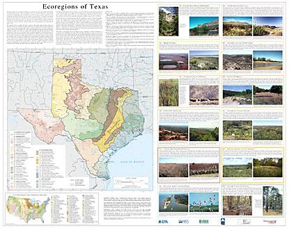
- Level IV Ecoregions of Texas--poster front side 45" X 35" (3.5 mb)
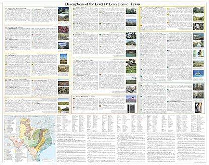
- Level IV Ecoregions of Texas--poster back side 46" X 36" (2.6 mb)
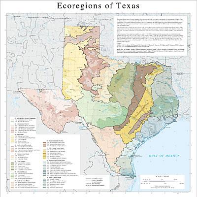
- Level III and IV Ecoregions of Texas--24" X 24" (784 kb)
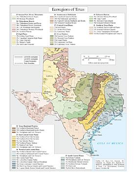
- Level III and IV Ecoregions of Texas--page size (276 kb)
Report (available in PDF format)
Ecoregions denote areas of general similarity in ecosystems and in the type, quality, and quantity of environmental resources. They are designed to serve as a spatial framework for the research, assessment, management, and monitoring of ecosystems and ecosystem components. By recognizing the spatial differences in the capacities and potentials of ecosystems, ecoregions stratify the environment by its probable response to disturbance (Bryce and others, 1999). These general purpose regions are critical for structuring and implementing ecosystem management strategies across federal agencies, state agencies, and nongovernment organizations that are responsible for different types of resources within the same geographical areas (Omernik and others, 2000).
The approach used to compile this map is based on the premise that ecological regions are hierarchical and can be identified through the analysis of the spatial patterns and the composition of biotic and abiotic phenomena that affect or reflect differences in ecosystem quality and integrity (Wiken 1986; Omernik 1987, 1995). These phenomena include geology, physiography, vegetation, climate, soils, land use, wildlife, and hydrology. The relative importance of each characteristic varies from one ecological region to another regardless of the hierarchical level. A Roman numeral hierarchical scheme has been adopted for different levels of ecological regions. Level I is the coarsest level, dividing North America into 15 ecological regions. Level II divides the continent into 52 regions (Commission for Environmental Cooperation Working Group 1997). At level III, the continental United States contains 104 ecoregions and the conterminous United States has 84 ecoregions (United States Environmental Protection Agency [USEPA] 2003). Level IV, depicted here for the State of Texas, is a further refinement of level III ecoregions. Explanations of the methods used to define the USEPA’s ecoregions are given in Omernik (1995), Omernik and others (2000), and Gallant and others (1989).
Ecological and biological diversity of Texas is enormous. The state contains barrier islands and coastal lowlands, large river floodplain forests, rolling plains and plateaus, forested hills, deserts, and a variety of aquatic habitats. There are 12 level III ecoregions and 56 level IV ecoregions in Texas and most continue into ecologically similar parts of adjacent states in the U.S. or Mexico.
The level III and IV ecoregions on this poster were compiled at a scale of 1:250,000 and depict revisions and subdivisions of earlier level III ecoregions that were originally compiled at a smaller scale (USEPA 2003; Omernik 1987). This poster is part of a collaborative project primarily between USEPA Region VI, USEPA National Health and Environmental Effects Research Laboratory (Corvallis, Oregon), Texas Commission on Environmental Quality (TCEQ), and the United States Department of Agriculture-Natural Resources Conservation Service (NRCS). Collaboration and consultation also occurred with the United States Department of the Interior-Geological Survey (USGS)-Earth Resources Observation Systems Data Center, and with other State of Texas agencies and universities.
The project is associated with an interagency effort to develop a common framework of ecological regions (McMahon and others, 2001). Reaching that objective requires recognition of the differences in the conceptual approaches and mapping methodologies applied to develop the most common ecoregion-type frameworks, including those developed by the United States Forest Service (Bailey and others, 1994), the USEPA (Omernik 1987, 1995), and the NRCS (U.S. Department of Agriculture-Soil Conservation Service, 1981). As each of these frameworks is further refined, their differences are becoming less discernible. Regional collaborative projects such as this one in Texas, where some agreement has been reached among multiple resource management agencies, are a step toward attaining consensus and consistency in ecoregion frameworks for the entire nation.
Literature Cited:
Bailey, R.G., Avers, P.E., King, T., and McNab, W.H., eds., 1994, Ecoregions and subregions of the United States (map) (supplementary table of map unit descriptions compiled and edited by McNab, W.H., and Bailey, R.G.): Washington, D.C., U.S. Department of Agriculture-Forest Service, scale 1:7,500,000.
Bryce, S.A., Omernik, J.M., and Larsen, D.P., 1999, Ecoregions - a geographic framework to guide risk characterization and ecosystem management: Environmental Practice, v. 1, no. 3, p. 141-155.
Commission for Environmental Cooperation Working Group, 1997, Ecological regions of North America - toward a common perspective: Montreal, Quebec, Commission for Environmental Cooperation, 71 p.
Gallant, A.L., Whittier, T.R., Larsen, D.P., Omernik, J.M., and Hughes, R.M., 1989, Regionalization as a tool for managing environmental resources: Corvallis, Oregon, U.S. Environmental Protection Agency, EPA/600/3-89/060, 152 p.
McMahon, G., Gregonis, S.M., Waltman, S.W., Omernik, J.M., Thorson, T.D., Freeouf, J.A., Rorick, A.H., and Keys, J.E., 2001, Developing a spatial framework of common ecological regions for the conterminous United States: Environmental Management, v. 28, no. 3, p. 293-316.
Omernik, J.M., 1987, Ecoregions of the conterminous United States (map supplement): Annals of the Association of American Geographers, v. 77, no. 1, p. 118-125, scale 1:7,500,000.
Omernik, J.M., 1995, Ecoregions - a spatial framework for environmental management, in Davis, W.S., and Simon, T.P., eds., Biological assessment and criteria-tools for water resource planning and decision making: Boca Raton, Florida, Lewis Publishers, p. 49-62.
Omernik, J.M., Chapman, S.S., Lillie, R.A., and Dumke, R.T., 2000, Ecoregions of Wisconsin: Transactions of the Wisconsin Academy of Sciences, Arts and Letters, v. 88, no. 2000, p. 77-103.
U.S. Department of Agriculture-Soil Conservation Service, 1981, Land resource regions and major land resource areas of the United States: Agriculture Handbook 296, 156 p.
U.S. Environmental Protection Agency, 2003, Level III ecoregions of the continental United States (revision of Omernik, 1987): Corvallis, Oregon, U.S. Environmental Protection Agency-National Health and Environmental Effects Research Laboratory, Map M-1, various scales.
Wiken, E., 1986, Terrestrial ecozones of Canada: Ottawa, Environment Canada, Ecological Land Classification Series no. 19, 26 p.
PRINCIPAL AUTHORS: Glenn E. Griffith (Dynamac Corporation), Sandra A. Bryce (Dynamac Corporation), James M. Omernik (USGS), Jeffrey A. Comstock (Indus Corporation), Anne C. Rogers (TCEQ), Bill Harrison (TCEQ), Stephen L. Hatch (Texas A&M University), and David Bezanson (Natural Area Preservation Association).
COLLABORATORS AND CONTRIBUTORS: Philip A. Crocker (USEPA), Art Crowe (TCEQ), Micheal Golden (NRCS), Susan Casby-Horton (NRCS), James Greenwade (NRCS), Conrad Neitsch (NRCS), Shannen S. Chapman (Dynamac Corporation), Augie De La Cruz (TCEQ), Kevin Wagner (Texas State Soil and Water Conservation Board [TSSWCB]), Richard Egg (TSSWCB), Alan J. Woods (Oregon State University), Clark Hubbs (University of Texas), David L. Certain (The Nature Conservancy) and Thomas R. Loveland (USGS).
REVIEWERS: Charles T. Hallmark (Texas A&M University), Gordon Linam (Texas Parks and Wildlife Department [TPWD]), Milo Pyne (NatureServe), Judy Teague (NatureServe), and Raymond C. Telfair II (TPWD).
CITING THIS POSTER: Griffith, G.E., Bryce, S.A., Omernik, J.M., Comstock, J.A., Rogers, A.C., Harrison, B., Hatch, S.L., and Bezanson, D., 2004, Ecoregions of Texas (color poster with map, descriptive text, and photographs): Reston, Virginia, U.S. Geological Survey (map scale 1:2,500,000).
This project was partially supported by funds from the U.S. Environmental Protection Agency Region VI, Regional Applied Research Effort (RARE) and Total Maximum Daily Load (TMDL) programs.