Ecoregion Download Files by State - Region 7
Select a state for descriptive information about that state's Level III and IV ecoregions. Additionally, each state section contains links to downloadable maps in PDF format, and files containing GIS datasets (shapefiles, metadata, and symbology data).
Some Web content for Level IV Ecoregions is under construction. If you do not find a link to a state that has been completed, maps and GIS data are available on the Ecoregion FTP site and web content will be available shortly.
NOTE: maps and GIS files may differ. To make sure you are using the most current ecoregion data, download shapefiles of ecoregions.
- Iowa
GIS Data (shapefiles, metadata and symbology)
- Iowa Level III Shapefile (264 kb)
- Iowa Level III Metadata and Iowa Level III Symbology
- Iowa Level IV Shapefile (951 kb)
- Iowa Level IV Metadata and Iowa Level IV Symbology
- Instructions for applying symbology to ecoregions
Maps (available in PDF format)
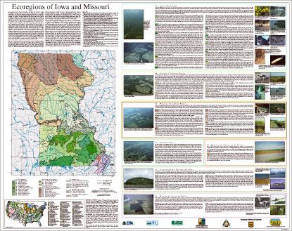
- Level IV Ecoregions of Iowa and Missouri--poster front side 46" X 36" (5.9 mb)
- Level IV Ecoregions of Iowa and Missouri--poster back side 46" X 36" (1.6 mb)
- Level III and IV Ecoregions of Iowa and Missouri--24" X 27" (1.4 m
- Level III and IV Ecoregions of Iowa and Missouri--page size (1.1 mb)
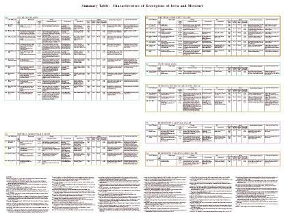
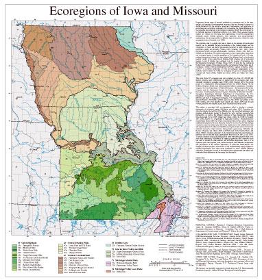
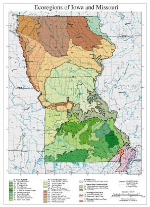
Ecoregions denote areas of general similarity in ecosystems and in the type, quality, and quantity of environmental resources; they are designed to serve as a spatial framework for the research, assessment, management, and monitoring of ecosystems and ecosystem components. Ecoregions are directly applicable to the immediate needs of state agencies, including the development of biological criteria and water quality standards, and the establishment of management goals for nonpoint-source pollution. They are also relevant to integrated ecosystem management, an ultimate goal of most federal and state resource management agencies.
The approach used to compile this map is based on the premise that ecological regions can be identified through the analysis of the patterns of biotic and abiotic phenomena that reflect differences in ecosystem quality and integrity (Wiken, 1986; Omernik, 1987, 1995). These phenomena include geology, physiography, vegetation, climate, soils, land use, wildlife, and hydrology. The relative importance of each characteristic varies from one ecological region to another regardless of the hierarchical level. A Roman numeral hierarchical scheme has been adopted for different levels of ecological regions. Level I and level II divide the North American continent into 15 and 52 regions, respectively (Commission for Environmental Cooperation Working Group 1997). At level III, the continental United States contains 104 regions (United States Environmental Protection Agency [US EPA], 2000). However, depending on the objectives of a particular project, ecoregions may be aggregated within levels of the hierarchy for data analysis and interpretation. Explanations of the methods used to define the US EPA’s ecoregions are given in Omernik (1995), Griffith and others (1994), and Gallant and others (1989).
This level III and IV ecoregion map was compiled at a 1:250,000-scale; it depicts revisions and subdivisions of earlier level III ecoregions that were originally compiled at a smaller scale (US EPA, 2000; Omernik, 1987). This poster is the product of a collaborative effort primarily between the US EPA Region VII, the US EPA National Health and Environmental Effects Research Laboratory (Corvallis, Oregon), the Missouri Department of Environmental Quality (NDEQ), the Missouri Game and Parks Commission (NGPC), the Iowa Biological Survey (KBS), the Iowa Geological Survey (KGS), the Iowa Department of Health and Environment, Division of Environment (KDHE), Iowa Department of Wildlife and Parks (KDWP), the United States Department of Agriculture - Natural Resources Conservation Service (NRCS) (formerly the Soil Conservation Service), and the United States Department of the Interior - U.S. Geological Survey (USGS) - Earth Resources Observation Systems (EROS) Data Center.
This project is associated with an interagency effort to develop a common framework of ecological regions. Reaching that objective requires recognition of the differences in the conceptual approaches and mapping methodologies that have been used to develop the most commonly used existing ecoregion-type frameworks, including those developed by the USFS (United States Forest Service) (Bailey and others, 1994), the US EPA (Omernik, 1987, 1995), and the NRCS (United States Department of Agriculture - Soil Conservation Service, 1981). As each of these frameworks is further developed, the differences between them lessen. Regional collaborative projects such as this one in Missouri and Iowa, where agreement can be reached among multiple resource management agencies, is a step in the direction of attaining commonality and consistency in ecoregion frameworks for the entire nation.
Literature Cited:
Bailey, R.G., Avers, P.E., King, T., and McNab, W.H., eds., 1994, Ecoregions and subregions of the United States (map) (supplementary table of map unit descriptions compiled and edited by McNab, W.H. and Bailey, R.G.): Washington, D.C., U.S. Department of Agriculture - Forest Service, scale 1:7,500,000.
Commission for Environmental Cooperation Working Group, 1997, Ecological regions of North America - toward a common perspective: Montreal, Quebec, Commission for Environmental Cooperation, 71 p.
Gallant, A.L., Whittier, T.R., Larsen, D.P., Omernik, J.M., and Hughes, R.M., 1989, Regionalization as a tool for managing environmental resources: Corvallis, Oregon, U.S. Environmental Protection Agency EPA/600/3-89/060, 152 p.
Griffith, G.E, Omernik, J.M., Wilton, T.F., and Pierson, S.M., 1994, Ecoregions and subregions of Iowa - a framework for water quality assessment and management: The Journal of the Iowa Academy of Science, v. 101, no. 1, p. 5-13.
Omernik, J.M, 1987, Ecoregions of the conterminous United States (map supplement): Annals of the Association of American Geographers, v. 77, no. 1, p. 118-125, scale 1:7,500,000.
Omernik, J.M, 1995, Ecoregions - a framework for environmental management, in Davis, W.S. and Simon, T.P., eds., Biological assessment and criteria - tools for water resource planning and decision making: Boca Raton, Florida, Lewis Publishers, p. 49-62.
U.S. Department of Agriculture - Soil Conservation Service, 1981, Land resource regions and major land resource areas of the United States: Agriculture Handbook 296, 156 p.
U.S. Environmental Protection Agency, 2000, Level III ecoregions of the continental United States (revision of Omernik, 1987): Corvallis, Oregon, U.S. Environmental Protection Agency - National Health and Environmental Effects Research Laboratory Map M-1, various scales.
Wiken, E, 1986, Terrestrial ecozones of Canada: Ottawa, Environment Canada, Ecological Land Classification Series no. 19, 26 p.
PRINCIPAL AUTHORS: Shannen S. Chapman (Dynamac Corporation), James M. Omernik (USEPA), Glenn E. Griffith (NRCS), Walter A. Schroeder (University of Missouri - Columbia), Tim A. Nigh (Missouri Department of Conservation), and Thomas F. Wilton (Iowa DNR).
COLLABORATORS AND CONTRIBUTORS: Randy Sarver (Missouri DNR-Environmental Services Program), Dennis Potter (NRCS), John Olson (Iowa DNR-Environmental Protection Division), Cheryl Seeger (Missouri DNR - Division of Geology and Land Survey), Terry Barney (NRCS), Larry Shepard (USEPA - Region VII), Gary Welker (USEPA -Region VII), Dennis Meinert (Missouri DNR - Soil and Water Conservation Program), Jeffrey A. Comstock (INDUS Corporation)
REVIEWERS Jerry Vineyard (Retired, Missouri DNR - Division of Geology and Land Survey), Blane Heumann (The Nature Conservancy), Jean Prior and James Giglierano (Iowa DNR - Geologic Survey Bureau).
This project was partially supported by funds from the U.S. Environmental Protection Agency’s Office of Water, Biological Criteria Program.
CITING THIS POSTER: Chapman, S.S., Omernik, J.M., Griffith, G.E., Schroeder, W.A., Nigh, T.A., and Wilton, T.F., 2002, Ecoregions of Iowa and Missouri (color poster with map, descriptive text, summary tables, and photographs): Reston, Virginia, U.S. Geological Survey (map scale 1:1,800,000).
- Kansas
GIS Data (shapefiles, metadata and symbology)
- Kansas Level III Shapefile (188 kb)
- Kansas Level III Metadata and Kansas Level III Symbology
- Kansas Level IV Shapefile (336 kb)
- Kansas Level IV Metadata and Kansas Level IV Symbology
- Instructions for applying symbology to ecoregions
Maps (available in PDF format)
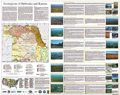
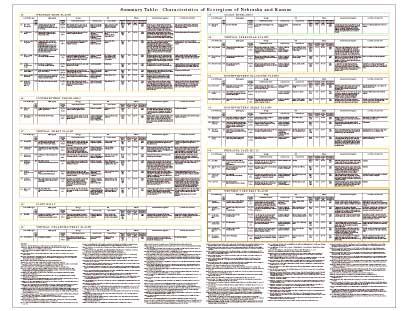
- Level IV Ecoregions of Kansas and Nebraska--poster front side 46" X 36" (4 mb)
- Level IV Ecoregions of Kansas and Nebraska--poster back side 46" X 36" (152 kb)
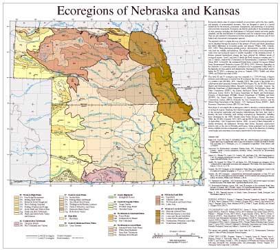
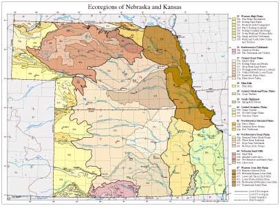
- Level III and IV Ecoregions of Kansas and Nebraska--25" X 24" (896 kb)
- Level III and IV Ecoregions of Kansas and Nebraska--page size (1.2 mb)
Ecoregions denote areas of general similarity in ecosystems and in the type, quality, and quantity of environmental resources; they are designed to serve as a spatial framework for the research, assessment, management, and monitoring of ecosystems and ecosystem components. Ecoregions are directly applicable to the immediate needs of state agencies, including the development of biological criteria and water quality standards, and the establishment of management goals for nonpoint-source pollution. They are also relevant to integrated ecosystem management, an ultimate goal of most federal and state resource management agencies.
The approach used to compile this map is based on the premise that ecological regions can be identified through the analysis of the patterns of biotic and abiotic phenomena that reflect differences in ecosystem quality and integrity (Wiken, 1986; Omernik, 1987, 1995). These phenomena include geology, physiography, vegetation, climate, soils, land use, wildlife, and hydrology. The relative importance of each characteristic varies from one ecological region to another regardless of the hierarchical level. A Roman numeral hierarchical scheme has been adopted for different levels of ecological regions. Level I and level II divide the North American continent into 15 and 52 regions, respectively (Commission for Environmental Cooperation Working Group 1997). At level III, the continental United States contains 104 regions (United States Environmental Protection Agency [US EPA], 2000). However, depending on the objectives of a particular project, ecoregions may be aggregated within levels of the hierarchy for data analysis and interpretation. Explanations of the methods used to define the US EPA’s ecoregions are given in Omernik (1995), Griffith and others (1994), and Gallant and others (1989).
This level III and IV ecoregion map was compiled at a 1:250,000-scale; it depicts revisions and subdivisions of earlier level III ecoregions that were originally compiled at a smaller scale (US EPA, 2000; Omernik, 1987). This poster is the product of a collaborative effort primarily between the US EPA Region VII, the US EPA National Health and Environmental Effects Research Laboratory (Corvallis, Oregon), the Nebraska Department of Environmental Quality (NDEQ), the Nebraska Game and Parks Commission (NGPC), the Kansas Biological Survey (KBS), the Kansas Geological Survey (KGS), the Kansas Department of Health and Environment, Division of Environment (KDHE), Kansas Department of Wildlife and Parks (KDWP), the United States Department of Agriculture - Natural Resources Conservation Service (NRCS) (formerly the Soil Conservation Service), and the United States Department of the Interior - U.S. Geological Survey (USGS) - Earth Resources Observation Systems (EROS) Data Center.
This project is associated with an interagency effort to develop a common framework of ecological regions. Reaching that objective requires recognition of the differences in the conceptual approaches and mapping methodologies that have been used to develop the most commonly used existing ecoregion-type frameworks, including those developed by the USFS (United States Forest Service) (Bailey and others, 1994), the US EPA (Omernik, 1987, 1995), and the NRCS (United States Department of Agriculture - Soil Conservation Service, 1981). As each of these frameworks is further developed, the differences between them lessen. Regional collaborative projects such as this one in Nebraska and Kansas, where agreement can be reached among multiple resource management agencies, is a step in the direction of attaining commonality and consistency in ecoregion frameworks for the entire nation.
Literature Cited:
Bailey, R.G., Avers, P.E., King, T., and McNab, W.H., eds., 1994, Ecoregions and subregions of the United States (map) (supplementary table of map unit descriptions compiled and edited by McNab, W.H. and Bailey, R.G.): Washington, D.C., U.S. Department of Agriculture - Forest Service, scale 1:7,500,000.
Commission for Environmental Cooperation Working Group, 1997, Ecological regions of North America - toward a common perspective: Montreal, Quebec, Commission for Environmental Cooperation, 71 p.
Gallant, A.L., Whittier, T.R., Larsen, D.P., Omernik, J.M., and Hughes, R.M., 1989, Regionalization as a tool for managing environmental resources: Corvallis, Oregon, U.S. Environmental Protection Agency EPA/600/3-89/060, 152 p.
Griffith, G.E, Omernik, J.M., Wilton, T.F., and Pierson, S.M., 1994, Ecoregions and subregions of Iowa - a framework for water quality assessment and management: The Journal of the Iowa Academy of Science, v. 101, no. 1, p. 5-13.
Omernik, J.M, 1987, Ecoregions of the conterminous United States (map supplement): Annals of the Association of American Geographers, v. 77, no. 1, p. 118-125, scale 1:7,500,000.
Omernik, J.M, 1995, Ecoregions - a framework for environmental management, in Davis, W.S. and Simon, T.P., eds., Biological assessment and criteria - tools for water resource planning and decision making: Boca Raton, Florida, Lewis Publishers, p. 49-62.
U.S. Department of Agriculture - Soil Conservation Service, 1981, Land resource regions and major land resource areas of the United States: Agriculture Handbook 296, 156 p.
U.S. Environmental Protection Agency, 2000, Level III ecoregions of the continental United States (revision of Omernik, 1987): Corvallis, Oregon, U.S. Environmental Protection Agency - National Health and Environmental Effects Research Laboratory Map M-1, various scales.
Wiken, E, 1986, Terrestrial ecozones of Canada: Ottawa, Environment Canada, Ecological Land Classification Series no. 19, 26 p.
PRINCIPAL AUTHORS: Shannen S. Chapman (Dynamac Corporation), James M. Omernik (US EPA), Jerry A. Freeouf (USFS), Donald G. Huggins (KBS), James R. McCauley (KGS), Craig C. Freeman (KBS), Gerry Steinauer (NGPC), Robert T. Angelo (KDHE), and Richard L. Schlepp (USDA, NRCS).
COLLABORATORS AND CONTRIBUTORS: Steven R. Walker (NDEQ), Kenneth R. Bazata (NDEQ), Sharon W. Waltman (USDA, NRCS-National Soil Survey Center [NSSC]), William J. Waltman (USDA, NRCS-NSSC), Roger Kanable (USDA, NRCS), Steven C. Schainost (NGPC), Craig Engelhard (USDA, NRCS), James W. Merchant (Center for Advanced Land Management Information Technologies [CALMIT], University of Nebraska, Lincoln [UNL]), Virginia L. McGuire (USGS), Chris Mammoliti (KDWP), James L. Stubbendieck (UNL), David A. Mortensen (UNL), Thomas Wardle (Nebraska Forest Service), David T. Lewis (UNL), Robert F. Diffendal Jr. (Nebraska Conservation and Survey Division-Nebraska Geological Survey) and Jeffrey A. Comstock (OAO Corporation).
This project was partially supported by funds from the U.S. Environmental Protection Agency’s Office of Water, Biological Criteria Program.
CITING THIS POSTER: Chapman, Shannen S., Omernik, James M., Freeouf, Jerry A., Huggins, Donald G., McCauley, James R., Freeman, Craig C., Steinauer, Gerry, Angelo, Robert T., and Schlepp, Richard L., 2001, Ecoregions of Nebraska and Kansas (color poster with map, descriptive text, summary tables, and photographs): Reston, Virginia, U.S. Geological Survey (map scale 1:1,950,000).
- Missouri
GIS Data (shapefiles, metadata and symbology)
- Missouri Level III Shapefile (549 kb)
- Missouri Level III Metadata and Missouri Level III Symbology
- Missouri Level IV Shapefile (898 kb)
- Missouri Level IV Metadata and Missouri Level IV Symbology
- Instructions for applying symbology to ecoregions
Maps (available in PDF format)
- Level IV Ecoregions of Iowa and Missouri--poster front side 46" X 36" (5.9 mb)
- Level IV Ecoregions of Iowa and Missouri--poster back side 46" X 36" (1.6 mb)
- Level III and IV Ecoregions of Iowa and Missouri--24" X 27" (1.4 m
- Level III and IV Ecoregions of Iowa and Missouri--page size (1.1 mb)
Ecoregions denote areas of general similarity in ecosystems and in the type, quality, and quantity of environmental resources; they are designed to serve as a spatial framework for the research, assessment, management, and monitoring of ecosystems and ecosystem components. Ecoregions are directly applicable to the immediate needs of state agencies, including the development of biological criteria and water quality standards, and the establishment of management goals for nonpoint-source pollution. They are also relevant to integrated ecosystem management, an ultimate goal of most federal and state resource management agencies.
The approach used to compile this map is based on the premise that ecological regions can be identified through the analysis of the patterns of biotic and abiotic phenomena that reflect differences in ecosystem quality and integrity (Wiken, 1986; Omernik, 1987, 1995). These phenomena include geology, physiography, vegetation, climate, soils, land use, wildlife, and hydrology. The relative importance of each characteristic varies from one ecological region to another regardless of the hierarchical level. A Roman numeral hierarchical scheme has been adopted for different levels of ecological regions. Level I and level II divide the North American continent into 15 and 52 regions, respectively (Commission for Environmental Cooperation Working Group 1997). At level III, the continental United States contains 104 regions (United States Environmental Protection Agency [US EPA], 2000). However, depending on the objectives of a particular project, ecoregions may be aggregated within levels of the hierarchy for data analysis and interpretation. Explanations of the methods used to define the US EPA’s ecoregions are given in Omernik (1995), Griffith and others (1994), and Gallant and others (1989).
This level III and IV ecoregion map was compiled at a 1:250,000-scale; it depicts revisions and subdivisions of earlier level III ecoregions that were originally compiled at a smaller scale (US EPA, 2000; Omernik, 1987). This poster is the product of a collaborative effort primarily between the US EPA Region VII, the US EPA National Health and Environmental Effects Research Laboratory (Corvallis, Oregon), the Missouri Department of Environmental Quality (NDEQ), the Missouri Game and Parks Commission (NGPC), the Iowa Biological Survey (KBS), the Iowa Geological Survey (KGS), the Iowa Department of Health and Environment, Division of Environment (KDHE), Iowa Department of Wildlife and Parks (KDWP), the United States Department of Agriculture - Natural Resources Conservation Service (NRCS) (formerly the Soil Conservation Service), and the United States Department of the Interior - U.S. Geological Survey (USGS) - Earth Resources Observation Systems (EROS) Data Center.
This project is associated with an interagency effort to develop a common framework of ecological regions. Reaching that objective requires recognition of the differences in the conceptual approaches and mapping methodologies that have been used to develop the most commonly used existing ecoregion-type frameworks, including those developed by the USFS (United States Forest Service) (Bailey and others, 1994), the US EPA (Omernik, 1987, 1995), and the NRCS (United States Department of Agriculture - Soil Conservation Service, 1981). As each of these frameworks is further developed, the differences between them lessen. Regional collaborative projects such as this one in Missouri and Iowa, where agreement can be reached among multiple resource management agencies, is a step in the direction of attaining commonality and consistency in ecoregion frameworks for the entire nation.
Literature Cited:
Bailey, R.G., Avers, P.E., King, T., and McNab, W.H., eds., 1994, Ecoregions and subregions of the United States (map) (supplementary table of map unit descriptions compiled and edited by McNab, W.H. and Bailey, R.G.): Washington, D.C., U.S. Department of Agriculture - Forest Service, scale 1:7,500,000.
Commission for Environmental Cooperation Working Group, 1997, Ecological regions of North America - toward a common perspective: Montreal, Quebec, Commission for Environmental Cooperation, 71 p.
Gallant, A.L., Whittier, T.R., Larsen, D.P., Omernik, J.M., and Hughes, R.M., 1989, Regionalization as a tool for managing environmental resources: Corvallis, Oregon, U.S. Environmental Protection Agency EPA/600/3-89/060, 152 p.
Griffith, G.E, Omernik, J.M., Wilton, T.F., and Pierson, S.M., 1994, Ecoregions and subregions of Iowa - a framework for water quality assessment and management: The Journal of the Iowa Academy of Science, v. 101, no. 1, p. 5-13.
Omernik, J.M, 1987, Ecoregions of the conterminous United States (map supplement): Annals of the Association of American Geographers, v. 77, no. 1, p. 118-125, scale 1:7,500,000.
Omernik, J.M, 1995, Ecoregions - a framework for environmental management, in Davis, W.S. and Simon, T.P., eds., Biological assessment and criteria - tools for water resource planning and decision making: Boca Raton, Florida, Lewis Publishers, p. 49-62.
U.S. Department of Agriculture - Soil Conservation Service, 1981, Land resource regions and major land resource areas of the United States: Agriculture Handbook 296, 156 p.
U.S. Environmental Protection Agency, 2000, Level III ecoregions of the continental United States (revision of Omernik, 1987): Corvallis, Oregon, U.S. Environmental Protection Agency - National Health and Environmental Effects Research Laboratory Map M-1, various scales.
Wiken, E, 1986, Terrestrial ecozones of Canada: Ottawa, Environment Canada, Ecological Land Classification Series no. 19, 26 p.
PRINCIPAL AUTHORS: Shannen S. Chapman (Dynamac Corporation), James M. Omernik (USEPA), Glenn E. Griffith (NRCS), Walter A. Schroeder (University of Missouri - Columbia), Tim A. Nigh (Missouri Department of Conservation), and Thomas F. Wilton (Iowa DNR).
COLLABORATORS AND CONTRIBUTORS: Randy Sarver (Missouri DNR-Environmental Services Program), Dennis Potter (NRCS), John Olson (Iowa DNR-Environmental Protection Division), Cheryl Seeger (Missouri DNR - Division of Geology and Land Survey), Terry Barney (NRCS), Larry Shepard (USEPA - Region VII), Gary Welker (USEPA -Region VII), Dennis Meinert (Missouri DNR - Soil and Water Conservation Program), Jeffrey A. Comstock (INDUS Corporation)
REVIEWERS Jerry Vineyard (Retired, Missouri DNR - Division of Geology and Land Survey), Blane Heumann (The Nature Conservancy), Jean Prior and James Giglierano (Iowa DNR - Geologic Survey Bureau).
This project was partially supported by funds from the U.S. Environmental Protection Agency’s Office of Water, Biological Criteria Program.
CITING THIS POSTER: Chapman, S.S., Omernik, J.M., Griffith, G.E., Schroeder, W.A., Nigh, T.A., and Wilton, T.F., 2002, Ecoregions of Iowa and Missouri (color poster with map, descriptive text, summary tables, and photographs): Reston, Virginia, U.S. Geological Survey (map scale 1:1,800,000).
- Nebraska
GIS Data (shapefiles, metadata and symbology)
- Nebraska Level III Shapefile (318 kb)
- Nebraska Level III Metadata and Nebraska Level III Symbology
- Nebraska Level IV Shapefile (772 mb)
- Nebraska Level IV Metadata and Nebraska Level IV Symbology
- Instructions for applying symbology to ecoregions
Maps (available in PDF format)
- Level IV Ecoregions of Kansas and Nebraska--poster front side 46" X 36" (4 mb)
- Level IV Ecoregions of Kansas and Nebraska--poster back side 46" X 36" (152 kb)
- Level III and IV Ecoregions of Kansas and Nebraska--25" X 24" (896 kb)
- Level III and IV Ecoregions of Kansas and Nebraska--page size (1.2 mb)
Ecoregions denote areas of general similarity in ecosystems and in the type, quality, and quantity of environmental resources; they are designed to serve as a spatial framework for the research, assessment, management, and monitoring of ecosystems and ecosystem components. Ecoregions are directly applicable to the immediate needs of state agencies, including the development of biological criteria and water quality standards, and the establishment of management goals for nonpoint-source pollution. They are also relevant to integrated ecosystem management, an ultimate goal of most federal and state resource management agencies.
The approach used to compile this map is based on the premise that ecological regions can be identified through the analysis of the patterns of biotic and abiotic phenomena that reflect differences in ecosystem quality and integrity (Wiken, 1986; Omernik, 1987, 1995). These phenomena include geology, physiography, vegetation, climate, soils, land use, wildlife, and hydrology. The relative importance of each characteristic varies from one ecological region to another regardless of the hierarchical level. A Roman numeral hierarchical scheme has been adopted for different levels of ecological regions. Level I and level II divide the North American continent into 15 and 52 regions, respectively (Commission for Environmental Cooperation Working Group 1997). At level III, the continental United States contains 104 regions (United States Environmental Protection Agency [US EPA], 2000). However, depending on the objectives of a particular project, ecoregions may be aggregated within levels of the hierarchy for data analysis and interpretation. Explanations of the methods used to define the US EPA’s ecoregions are given in Omernik (1995), Griffith and others (1994), and Gallant and others (1989).
This level III and IV ecoregion map was compiled at a 1:250,000-scale; it depicts revisions and subdivisions of earlier level III ecoregions that were originally compiled at a smaller scale (US EPA, 2000; Omernik, 1987). This poster is the product of a collaborative effort primarily between the US EPA Region VII, the US EPA National Health and Environmental Effects Research Laboratory (Corvallis, Oregon), the Nebraska Department of Environmental Quality (NDEQ), the Nebraska Game and Parks Commission (NGPC), the Kansas Biological Survey (KBS), the Kansas Geological Survey (KGS), the Kansas Department of Health and Environment, Division of Environment (KDHE), Kansas Department of Wildlife and Parks (KDWP), the United States Department of Agriculture - Natural Resources Conservation Service (NRCS) (formerly the Soil Conservation Service), and the United States Department of the Interior - U.S. Geological Survey (USGS) - Earth Resources Observation Systems (EROS) Data Center.
This project is associated with an interagency effort to develop a common framework of ecological regions. Reaching that objective requires recognition of the differences in the conceptual approaches and mapping methodologies that have been used to develop the most commonly used existing ecoregion-type frameworks, including those developed by the USFS (United States Forest Service) (Bailey and others, 1994), the US EPA (Omernik, 1987, 1995), and the NRCS (United States Department of Agriculture - Soil Conservation Service, 1981). As each of these frameworks is further developed, the differences between them lessen. Regional collaborative projects such as this one in Nebraska and Kansas, where agreement can be reached among multiple resource management agencies, is a step in the direction of attaining commonality and consistency in ecoregion frameworks for the entire nation.
Literature Cited:
Bailey, R.G., Avers, P.E., King, T., and McNab, W.H., eds., 1994, Ecoregions and subregions of the United States (map) (supplementary table of map unit descriptions compiled and edited by McNab, W.H. and Bailey, R.G.): Washington, D.C., U.S. Department of Agriculture - Forest Service, scale 1:7,500,000.
Commission for Environmental Cooperation Working Group, 1997, Ecological regions of North America - toward a common perspective: Montreal, Quebec, Commission for Environmental Cooperation, 71 p.
Gallant, A.L., Whittier, T.R., Larsen, D.P., Omernik, J.M., and Hughes, R.M., 1989, Regionalization as a tool for managing environmental resources: Corvallis, Oregon, U.S. Environmental Protection Agency EPA/600/3-89/060, 152 p.
Griffith, G.E, Omernik, J.M., Wilton, T.F., and Pierson, S.M., 1994, Ecoregions and subregions of Iowa - a framework for water quality assessment and management: The Journal of the Iowa Academy of Science, v. 101, no. 1, p. 5-13.
Omernik, J.M, 1987, Ecoregions of the conterminous United States (map supplement): Annals of the Association of American Geographers, v. 77, no. 1, p. 118-125, scale 1:7,500,000.
Omernik, J.M, 1995, Ecoregions - a framework for environmental management, in Davis, W.S. and Simon, T.P., eds., Biological assessment and criteria - tools for water resource planning and decision making: Boca Raton, Florida, Lewis Publishers, p. 49-62.
U.S. Department of Agriculture - Soil Conservation Service, 1981, Land resource regions and major land resource areas of the United States: Agriculture Handbook 296, 156 p.
U.S. Environmental Protection Agency, 2000, Level III ecoregions of the continental United States (revision of Omernik, 1987): Corvallis, Oregon, U.S. Environmental Protection Agency - National Health and Environmental Effects Research Laboratory Map M-1, various scales.
Wiken, E, 1986, Terrestrial ecozones of Canada: Ottawa, Environment Canada, Ecological Land Classification Series no. 19, 26 p.
PRINCIPAL AUTHORS: Shannen S. Chapman (Dynamac Corporation), James M. Omernik (US EPA), Jerry A. Freeouf (USFS), Donald G. Huggins (KBS), James R. McCauley (KGS), Craig C. Freeman (KBS), Gerry Steinauer (NGPC), Robert T. Angelo (KDHE), and Richard L. Schlepp (USDA, NRCS).
COLLABORATORS AND CONTRIBUTORS: Steven R. Walker (NDEQ), Kenneth R. Bazata (NDEQ), Sharon W. Waltman (USDA, NRCS-National Soil Survey Center [NSSC]), William J. Waltman (USDA, NRCS-NSSC), Roger Kanable (USDA, NRCS), Steven C. Schainost (NGPC), Craig Engelhard (USDA, NRCS), James W. Merchant (Center for Advanced Land Management Information Technologies [CALMIT], University of Nebraska, Lincoln [UNL]), Virginia L. McGuire (USGS), Chris Mammoliti (KDWP), James L. Stubbendieck (UNL), David A. Mortensen (UNL), Thomas Wardle (Nebraska Forest Service), David T. Lewis (UNL), Robert F. Diffendal Jr. (Nebraska Conservation and Survey Division-Nebraska Geological Survey) and Jeffrey A. Comstock (OAO Corporation).
This project was partially supported by funds from the U.S. Environmental Protection Agency’s Office of Water, Biological Criteria Program.
CITING THIS POSTER: Chapman, Shannen S., Omernik, James M., Freeouf, Jerry A., Huggins, Donald G., McCauley, James R., Freeman, Craig C., Steinauer, Gerry, Angelo, Robert T., and Schlepp, Richard L., 2001, Ecoregions of Nebraska and Kansas (color poster with map, descriptive text, summary tables, and photographs): Reston, Virginia, U.S. Geological Survey (map scale 1:1,950,000).