Ecoregion Download Files by State - Region 8
Select a state for descriptive information about that state's Level III and IV ecoregions. Additionally, each state section contains links to downloadable maps in PDF format, and files containing GIS datasets (shapefiles, metadata, and symbology data).
Some Web content for Level IV Ecoregions is under construction. If you do not find a link to a state that has been completed, maps and GIS data are available on the Ecoregion FTP site and web content will be available shortly.
NOTE: maps and GIS files may differ. To make sure you are using the most current ecoregion data, download shapefiles of ecoregions.
- Colorado
GIS Data (shapefiles, metadata and symbology)
- Colorado Level III Shapefile (485 kb)
- Colorado Level III Metadata and Colorado Level III Symbology
- Colorado Level IV Shapefile (4 mb)
- Colorado Level IV Metadata and Colorado Level IV Symbology
- Instructions for applying symbology to ecoregions
Maps (available in PDF format)
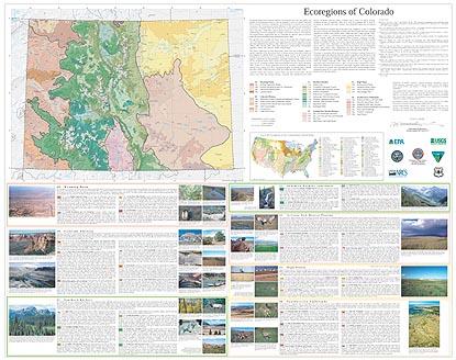
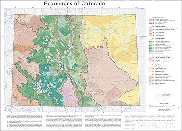
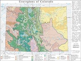
- Level IV Ecoregions of Colorado--poster front side 44.5" X 35.5" (3 mb)
- Level IV Ecoregions of Colorado--poster back side 46" X 36" (201 kb)
- Level III and IV Ecoregions of Colorado--25" X 29" (931 kb)
- Level III and IV Ecoregions of Colorado--page size (541 kb)
Ecoregions denote areas of general similarity in ecosystems and in the type, quality, and quantity of environmental resources; they are designed to serve as a spatial framework for the research, assessment, management, and monitoring of ecosystems and ecosystem components. By recognizing the spatial differences in the capacities and potentials of ecosystems, ecoregions stratify the environment by its probable response to disturbance (Bryce and others, 1999). These general purpose regions are critical for structuring and implementing ecosystem management strategies across federal agencies, state agencies, and nongovernment organizations that are responsible for different types of resources within the same geographical areas (Omernik and others, 2000).
The approach used to compile this map is based on the premise that ecological regions can be identified through the analysis of the spatial patterns and the composition of biotic and abiotic phenomena that affect or reflect differences in ecosystem quality and integrity (Wiken, 1986; Omernik, 1987, 1995). These phenomena include geology, physiography, vegetation, climate, soils, land use, wildlife, and hydrology.
The relative importance of each characteristic varies from one ecological region to another, regardless of the hierarchical level. A Roman numeral hierarchical scheme has been adopted for different levels of ecological regions. Level I is the coarsest level, dividing North America into 15 ecological regions. Level II divides the continent into 52 regions (Commission for Environmental Cooperation Working Group, 1997). At level III, the continental United States contains 104 ecoregions and the conterminous United States has 84 ecoregions (United States Environmental Protection Agency [USEPA], 2003). Level IV is a further subdivision of level III ecoregions. Explanations of the methods used to define the USEPA’s ecoregions are given in Omernik (1995), Omernik and others (2000), Griffith and others (1994), and Gallant and others (1989, 1995).
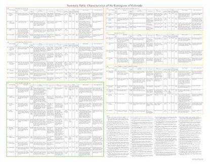
Colorado contains arid canyons, semiarid shrub- and grass-covered plains, alluvial valleys, lava fields and volcanic plateaus, woodland- and shrubland-covered hills, forested mountains, glaciated peaks, wetlands, and a variety of aquatic habitats. Ecological diversity is enormous. There are 6 level III ecoregions and 35 level IV ecoregions in Colorado, and many continue into ecologically similar parts of adjacent states.
The level III and IV ecoregion map on this poster was compiled at a scale of 1:250,000 and depicts revisions and subdivisions of earlier level III ecoregions that were originally compiled at a smaller scale (USEPA, 2003; Gallant and others, 1989; Omernik, 1987). This poster is part of a collaborative project primarily between USEPA Region VIII, USEPA National Health and Environmental Effects Research Laboratory (Corvallis, Oregon), Colorado Department of Public Health and Environment (CDPHE), Colorado Division of Wildlife (CDOW), United States Department of Agriculture–Forest Service (USFS), United States Department of Agriculture–Natural Resources Conservation Service (NRCS), United States Department of the Interior–Bureau of Land Management (BLM), and United States Department of the Interior–Geological Survey (USGS)–National Center for Earth Resources Observation and Science (EROS).
The project is associated with an interagency effort to develop a common framework of ecological regions. Reaching that objective requires recognition of the differences in the conceptual approaches and mapping methodologies applied to develop the most common ecoregion-type frameworks, including those developed by the USFS (Bailey and others, 1994), the USEPA (Omernik, 1987, 1995), and the NRCS (U.S. Department of Agriculture–Soil Conservation Service, 1981). As each of these frameworks is further refined, their differences are becoming less discernible. Regional collaborative projects, such as this one in Colorado, where agreement has been reached among multiple resource management agencies, are a step toward attaining consensus and consistency in ecoregion frameworks for the entire nation.
Literature Cited:
Bailey, R.G., Avers, P.E., King, T., and McNab, W.H., eds., 1994, Ecoregions and subregions of the United States (map) (supplementary table of map unit descriptions compiled and edited by McNab, W.H., and Bailey, R.G.): Washington, D.C., USFS, scale 1:7,500,000.
Bryce, S.A., Omernik, J.M., and Larsen, D.P., 1999, Ecoregions – a geographic framework to guide risk characterization and ecosystem management: Environmental Practice, v. 1, no. 3, p. 141-155.
Commission for Environmental Cooperation Working Group, 1997, Ecological regions of North America – toward a common perspective: Montreal, Commission for Environmental Cooperation, 71 p.
Gallant, A.L., Binnian, E.F., Omernik, J.M., and Shasby, M.B., 1995, Ecoregions of Alaska: U.S. Geological Survey Professional Paper 1567, Washington D.C., 73 p.
Gallant, A.L., Whittier, T.R., Larsen, D.P., Omernik, J.M., and Hughes, R.M., 1989, Regionalization as a tool for managing environmental resources: Corvallis, Oregon, U.S. Environmental Protection Agency, EPA/600/3-89/060, 152 p.
Griffith, G.E., Omernik, J.M., Wilton, T.F., and Pierson, S.M., 1994, Ecoregions and subregions of Iowa – a framework for water quality assessment and management: Journal of the Iowa Academy of Science, v. 101, no. 1, p. 5-13.
Omernik, J.M., 1987, Ecoregions of the conterminous United States (map supplement): Annals of the Association of American Geographers, v. 77, no. 1, p. 118-125, scale 1:7,500,000.
Omernik, J.M., 1995, Ecoregions – a framework for environmental management, in Davis, W.S., and Simon, T.P., eds., Biological assessment and criteria-tools for water resource planning and decision making: Boca Raton, Florida, Lewis Publishers, p. 49-62.
Omernik, J.M., Chapman, S.S., Lillie, R.A., and Dumke, R.T., 2000, Ecoregions of Wisconsin: Transactions of the Wisconsin Academy of Sciences, Arts, and Letters, v. 88, p. 77-103.
U.S. Department of Agriculture–Soil Conservation Service, 1981, Land resource regions and major land resource areas of the United States: Agriculture Handbook 296, 156 p.
U.S. Environmental Protection Agency, 2003, Level III ecoregions of the continental United States (revision of Omernik, 1987): Corvallis, Oregon, USEPA – National Health and Environmental Effects Research Laboratory, Map M-1, various scales.
Wiken, E., 1986, Terrestrial ecozones of Canada: Ottawa, Environment Canada, Ecological Land Classification Series no. 19, 26 p.
PRINCIPAL AUTHORS: Shannen S. Chapman (Dynamac Corporation), Glenn E. Griffith (Dynamac Corporation), James M. Omernik (USGS), Alan B. Price (NRCS), Jerry Freeouf (USFS), and Donald L. Schrupp (CO Department of Wildlife [CODOW]).
COLLABORATORS AND CONTRIBUTORS: Tony Selle (USEPA), Shannon Albeke (CODOW), Sandy Bryce (Dynamac Corporation), Ed Rumbold (BLM), Tom Weber (NRCS), Carol Dawson, (BLM), Eric Waller (CODOW), Christy Pickens (CDPHE), Brian Moran (Indus Corporation), John Hutchinson (Science Applications International Corporation), and Jack Wittmann (USGS).
REVIEWERS: Patrick Comer (NatureServe), Alisa Gallant (USGS), Tom Huber (University of Colorado, Colorado Springs), and Ron West (CO State Parks).
CITING THIS POSTER: Chapman, S.S., Griffith, G.E., Omernik, J.M., Price, A.B., Freeouf, J., and Schrupp, D.L., 2006, Ecoregions of Colorado (color poster with map, descriptive text, summary tables, and photographs): Reston, Virginia, U.S. Geological Survey (map scale 1:1,200,000).
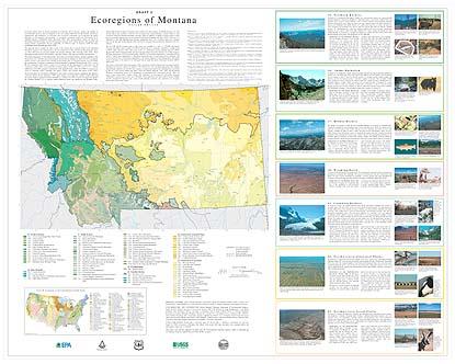
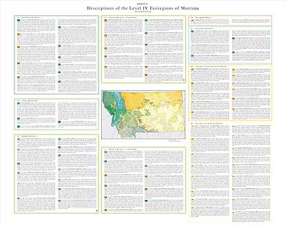
- Montana
GIS Data (shapefiles, metadata and symbology)
- Montana Level III Shapefile (681 kb)
- Montana Level III Metadata and Montana Level III Symbology
- Montana Level IV Shapefile (3.18 mb)
- Montana Level IV Metadata and Montana Level IV Symbology
- Instructions for applying symbology to ecoregions
Maps (available in PDF format)
- Level IV Ecoregions of Montana-- poster 1 front side 45" X 36" (1.8 mb)
- Level IV Ecoregions of Montana--poster 1 back side 45" X 36" (70 kb)
- Level IV Ecoregions of Montana--poster 2 front side 45" X 36" (581 kb)
- Level IV Ecoregions of Montana--poster 2 back side 45" X 36" (70 kb)
- Level IV Ecoregions of Montana-- 35" X 25" (539 kb)
- Level IV Ecoregions of Montana-- page size (561 kb)
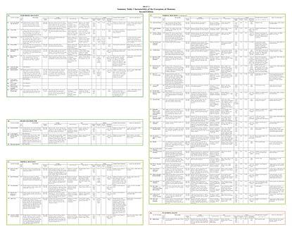
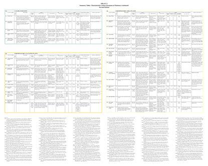
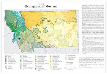
The second edition of "Ecoregions of Montana" revises many ecoregion polygon assignments that appeared in the first edition (Woods and others, 1999). These changes were made after research in Idaho (McGrath and others, 2002) recognized the Idaho Batholith as a separate level III ecoregion (Ecoregion 16), limited the Northern Rockies (15) to strongly marine-influenced areas, and transferred the Montana Valley and Foothill Prairies (formerly Ecoregion 16) to another level III ecoregion, the Middle Rockies (17). The second edition also modifies a few level IV ecoregion lines along Montana's western border so that ecoregions shared by Montana and Idaho will edge match. In addition, it updates ecoregion names so that they are consistent with the most recent ecoregion work in area (Chapman and others, 2003). However, it is important to note that although many polygon assignments and a few ecoregion names have changed between the first and second editions, nearly all level IV ecoregion line positions are identical on the two editions.
Ecoregions denote areas of general similarity in ecosystems and in the type, quality, and quantity of environmental resources; they are designed to serve as a spatial framework for the research, assessment, management, and monitoring of ecosystems and ecosystem components. Ecoregions are directly applicable to the immediate needs of state agencies, including the development of biological criteria and water quality standards and the establishment of management goals for nonpoint-source pollution. They are also relevant to integrated ecosystem management, an ultimate goal of most federal and state resource management agencies.
The approach used to compile this map is based on the premise that ecological regions can be identified through the analysis of the spatial patterns and the composition of biotic and abiotic phenomena that affect or reflect differences in ecosystem quality and integrity (Wiken 1986; Omernik 1987, 1995). These phenomena include geology, physiography, vegetation, climate, soils, land use, wildlife, and hydrology. The relative importance of each characteristic varies from one ecological region to another regardless of the hierarchical level. A Roman numeral hierarchical scheme has been adopted for different levels of ecological regions. Level I is the coarsest level, dividing North America into 15 ecological regions. Level II divides the continent into 52 regions (Commission for Environmental Cooperation Working Group 1997). At level III, the continental United States contains 104 regions (United States Environmental Protection Agency [USEPA], 1998). Level IV is a further subdivision of level III ecoregions. Explanations of the methods used to define the USEPA’s ecoregions are given in Omernik (1995), Griffith and others (1994), and Gallant and others (1989). The level III and IV ecoregion map on this poster was compiled at a scale of 1:250,000 and depicts revisions and subdivisions of earlier level III ecoregions that were originally compiled at a smaller scale (USEPA 1998; Omernik 1987). This poster is part of a collaborative project primarily between USEPA Region VIII, USEPA National Health and Environmental Effects Research Laboratory (Corvallis, Oregon), Montana Department of Environmental Quality (MDEQ), United States Department of Agriculture-Forest Service (USFS), United States Department of Agriculture-Natural Resources Conservation Service (NRCS) (formerly Soil Conservation Service), United States Department of the Interior-Bureau of Land Management (BLM), and United States Department of the Interior-U.S. Geological Survey (USGS)-Earth Resources Observation Systems (EROS) Data Center.
The project is associated with an interagency effort to develop a common framework of ecological regions. Reaching that objective requires recognition of the differences in the conceptual approaches and mapping methodologies applied to develop the most common ecoregion-type frameworks, including those developed by the USFS (Bailey and others, 1994), the USEPA (Omernik 1987, 1995), and the NRCS (U.S. Department of Agriculture-Soil Conservation Service, 1981). As each of these frameworks is further refined, their differences are becoming less discernible. Regional collaborative projects such as this one in Montana, where agreement has been reached among multiple resource management agencies, is a step toward attaining consensus and consistency in ecoregion frameworks for the entire nation.
Literature Cited:
Bailey, R.G., Avers, P.E., King, T., and McNab, W.H., eds., 1994, Ecoregions and subregions of the United States (map) (supplementary table of map unit descriptions compiled and edited by McNab, W.H. and Bailey, R.G.): Washington, D.C., USFS, scale 1:7,500,000.
Bryce, S.A., Omernik, J.M., and Larsen, D.P., 1999, Ecoregions – a geographic framework to guide risk characterization and ecosystem management: Environmental Practice, v. 1, no. 3, p. 141-155.
Chapman, S.S., Bryce, S.A., Omernik, J.M., Despain, D.G., ZumBerge, J., and Conrad, M., 2003, Ecoregions of Wyoming (color poster with map, descriptive text, summary tables, and photographs): Reston, Virginia, U.S. Geological Survey (map scale 1:1,400,000).
Commission for Environmental Cooperation Working Group, 1997, Ecological regions of North America – toward a common perspective: Montreal, Commission for Environmental Cooperation, 71 p.
Gallant, A.L., Whittier, T.R., Larsen, D.P., Omernik, J.M., and Hughes, R.M., 1989, Regionalization as a tool for managing environmental resources: Corvallis, Oregon, U.S. Environmental Protection Agency, EPA/600/3-89/060, 152 p.
Griffith, G.E., Omernik, J.M., Wilton, T.F., and Pierson, S.M., 1994, Ecoregions and subregions of Iowa – a framework for water quality assessment and management: Journal of the Iowa Academy of Science, v. 101, no. 1, p. 5-13.
McGrath C.L., Woods A.J., Omernik, J.M., Bryce, S.A., Edmondson, M., Nesser, J.A., Shelden, J., Crawford, R.C., Comstock, J.A., and Plocher, M.D., 2002, Ecoregions of Idaho (color poster with map, descriptive text, summary tables, and photographs): Reston, Virginia, U.S. Geological Survey (map scale 1:1,350,000).
Omernik, J.M., 1987, Ecoregions of the conterminous United States (map supplement): Annals of the Association of American Geographers, v. 77, no. 1, p. 118-125, scale 1:7,500,000.
Omernik, J.M., 1995, Ecoregions – a framework for environmental management, in Davis, W.S. and Simon, T.P., eds., Biological assessment and criteria-tools for water resource planning and decision making: Boca Raton, Florida, Lewis Publishers, p. 49-62.
Omernik, J.M., Chapman, S.S., Lillie, R.A., and Dumke, R.T., 2000, Ecoregions of Wisconsin: Transactions of the Wisconsin Academy of Sciences, Arts, and Letters, v. 88, p. 77-103.
U.S. Department of Agriculture–Soil Conservation Service, 1981, Land resource regions and major land resource areas of the United States: Agriculture Handbook 296, 156 p.
U.S. Environmental Protection Agency, 2000, Level III ecoregions of the continental United States (revision of Omernik, 1987): Corvallis, Oregon, USEPA – National Health and Environmental Effects Research Laboratory, Map M-1, various scales.
Wiken, E., 1986, Terrestrial ecozones of Canada: Ottawa, Environment Canada, Ecological Land Classification Series no. 19, 26 p.
Woods, Alan J., Omernik, James, M., Nesser, John A., Shelden, J., and Azevedo, Sandra H., 1999, Ecoregions of Montana (color poster with map, descriptive text, summary tables, and photographs): Reston, Virginia, U.S. Geological Survey (map scale 1:1,500,000).
PRINCIPAL AUTHORS: Alan J. Woods (Dynamac Corporation), James M. Omernik (USEPA), John A. Nesser (USFS), James Shelden (USFS), and Sandra H. Azevedo (OAO Corporation)
COLLABORATORS AND CONTRIBUTORS: Robert Bukantis (MDEQ), Chuck Gordon (NRCS), Bill Volk (BLM), Loren Bahls (Flathead Lake Biological Station, University of Montana), Dan Svoboda (USFS), Wease A. Bollman (Rhithron Biological Associates, Missoula, Montana), Thomas R. Loveland (USGS), Anthony Selle (USEPA), Alisa Gallant (Raytheon STX Corporation, Science Applications Branch, EROS Data Center), Cliff Montagne (Land Resources and Environmental Science, Montana State University), John Donahue (Department of Geography, University of Montana), and Jeff Comstock (OAO Corporation)
CITING THIS POSTER: Woods, Alan J., Omernik, James, M., Nesser, John A., Shelden, J., Comstock, J.A., Azevedo, Sandra H., 2002, Ecoregions of Montana, 2nd edition (color poster with map, descriptive text, summary tables, and photographs). Map scale 1:1,500,000.
This project was partially supported by funds from the Environmental Protection Agency's Office of Research and Development, Regional Applied Research Effort (RARE) program.
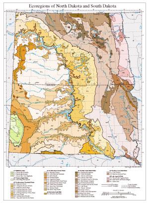
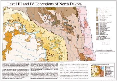
- North Dakota
GIS Data (shapefiles, metadata and symbology)
- North Dakota Level III Shapefile (272 kb)
- North Dakota Level III Metadata and North Dakota Level III Symbology
- North Dakota Level IV Shapefile (848 kb)
- North Dakota Level IV Metadata and North Dakota Level IV Symbology
Maps (available in PDF format)
- Level IV Ecoregions of North Dakota and South Dakota--poster front side 46" X 36" (4.8 mb)
- Level IV Ecoregions of North Dakota and South Dakota--poster back side 46" X 36" (536 kb)
- Level III and IV Ecoregions of North Dakota and South Dakota--24" X 27" (984 kb)
- Level III and IV Ecoregions of North Dakota and South Dakota--page size (1.1 mb)
- Level III and IV Ecoregions of North Dakota--30" X 23" (636 kb)
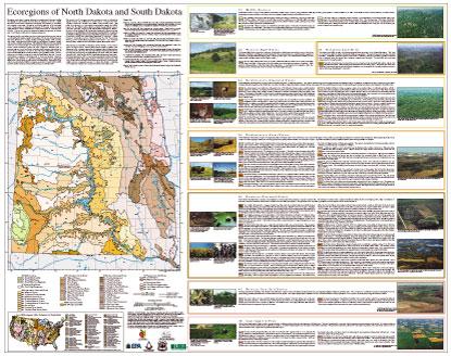
Ecoregions denote areas of general similarity in ecosystems and in the type, quality, and quantity of environmental resources; they are designed to serve as a spatial framework for the research, assessment, management, and monitoring of ecosystems and ecosystem components. Ecoregions are directly applicable to the immediate needs of state agencies, including the development of biological criteria and water quality standards, and the establishment of management goals for nonpoint-source pollution. They are also relevant to integrated ecosystem management, an ultimate goal of most federal and state resource management agencies.
The approach used to compile this map is based on the premise that ecological regions can be identified through the analysis of the patterns of biotic and abiotic phenomena that reflect differences in ecosystem quality and integrity (Wiken, 1986; Omernik, 1987, 1995). These phenomena include geology, physiography, vegetation, climate, soils, land use, wildlife, and hydrology. The relative importance of each characteristic varies from one ecological region to another regardless of the hierarchical level. A Roman numeral hierarchical scheme has been adopted for different levels of ecological regions. Level I and level II divide the North American continent into 15 and 51 regions, respectively. At level III, the continental United States contains 98 regions (United States Environmental Protection Agency [USEPA], 1996). Level IV regions are more detailed ecoregions for state-level applications; and level V are the most detailed ecoregions for landscape-level or local level projects. However, depending on the objectives of a particular project, ecoregions may be aggregated within levels of the hierarchy for data analysis and interpretation. Explanations of the methods used to define the USEPA's ecoregions are given in Omernik (1995), Griffith and others (1994), Gallant and others (1989), and Bryce and Clarke (1996).
This level III and IV ecoregion map was compiled at a scale of 1:250,000; it depicts revisions and subdivisions of earlier level III ecoregions that were originally compiled at a smaller scale (USEPA, 1996; Omernik, 1987). This poster is the product of a collaborative effort primarily between the USEPA Region VIII, the USEPA National Health and Environmental Effects Research Laboratory (Corvallis, Oregon), North Dakota State Department of Health - Division of Water Quality, South Dakota State Department of Environment and Natural Resources (SDDENR), South Dakota State University (SDSU) - Department of Wildlife and Fisheries Sciences, the United States Department of Agriculture - Forest Service (USFS), the United States Department of Agriculture - Natural Resources Conservation Service (NRCS) (formerly the Soil Conservation Service), and the United States Department of the Interior - U.S. Geological Survey (USGS) - Earth Resources Observation Systems (EROS) Data Center.
This project is associated with an interagency effort to develop a common frame-work of ecological regions. Reaching that objective requires recognition of the differences in the conceptual approaches and mapping methodologies that have been used to develop the most commonly used existing ecoregion-type frameworks, including those developed by the USFS (Bailey and others, 1994), the USEPA (Omernik, 1987, 1995), and the NRCS (United States Department of Agriculture - Soil Conservation Service, 1981). As each of these frameworks is further developed, the differences between them lessen. Regional collaborative projects such as this one in North Dakota and South Dakota, where agreement can be reached among multiple resource management agencies, is a step in the direction of attaining commonality and consistency in ecoregion frameworks for the entire nation.
Literature Cited:
Bailey, R.G., Avers, P.E., King, T., and McNab, W.H., eds., 1994, Ecoregions and subregions of the United States (map) (supplementary table of map unit descriptions compiled and edited by McNab, W.H. and Bailey, R.G.): Washington, D.C., U.S. Department of Agriculture - Forest Service, scale 1:7,500,000.Bryce, S.A. and Clarke, S.E., 1996, Landscape-level ecological regions: Linking state-level ecoregion frameworks with stream habitat classifications: Environmental Management, vol. 20, no. 3, p. 297-311.
Gallant, A.L., Whittier, T.R., Larsen, D.P., Omernik, J.M., and Hughes, R.M., 1989, Regionalization as a tool for managing environmental resources: Corvallis, Oregon, U.S. Environmental Protection Agency EPA/600/3-89/060, 152 p.
Griffith, G.E, Omernik, J.M., Wilton, T.F., and Pierson, S.M., 1994, Ecoregions and subregions of Iowa - a framework for water quality assessment and management: The Journal of the Iowa Academy of Science, v. 101, no. 1, p. 5-13.
Omernik, J.M., 1987, Ecoregions of the conterminous United States (map supplement): Annals of the Association of American Geographers, v. 77, no. 1, p. 118-125, scale 1:7,500,000.
Omernik, J.M., 1995, Ecoregions - a framework for environmental management, in Davis, W.S. and Simon, T.P., eds., Biological assessment and criteria - tools for water resource planning and decision making: Boca Raton, Florida, Lewis Publishers, p. 49-62.
U.S. Department of Agriculture - Soil Conservation Service, 1981, Land resource regions and major land resource areas of the United States: Agriculture Handbook 296, 156 p.
U.S. Environmental Protection Agency, 1996, Level III ecoregions of the continental United States (revision of Omernik, 1987): Corvallis, Oregon, U.S. Environmental Protection Agency - National Health and Environmental Effects Research Laboratory Map M-1, various scales.
Wiken, E., 1986, Terrestrial ecozones of Canada: Ottawa, Environment Canada, Ecological Land Classification Series no. 19, 26 p.
PRINCIPAL AUTHORS: Sandra A. Bryce (Dynamac Corporation), James M. Omernik (USEPA), David E. Pater (Dynamac Corporation), Michael Ulmer, Jerome Schaar (USDA, NRCS), Jerry Freeouf (USFS), Rex Johnson (SDSU), Pat Kuck (DENR/NRSC Liaison), and Sandra H. Azevedo (OAO Corporation).
COLLABORATORS AND CONTRIBUTORS: Lewis M. Cowardin (USGS, Biological Resources Division), Michael Ell (ND State Department of Health - Division of Water Quality), Harold Kantrud (USGS, Biological Resources Division), Kenneth Lindskov (USGS), Thomas R. Loveland (USGS), David J. Ode (SD Game, Fish and Parks), J. Foster Sawyer (SDDENR, Geological Survey), David Schmidt (USDA, NRCS), Anthony Selle (USEPA), Jeffery D. Stoner (USGS), and William Stewart (SDDENR).
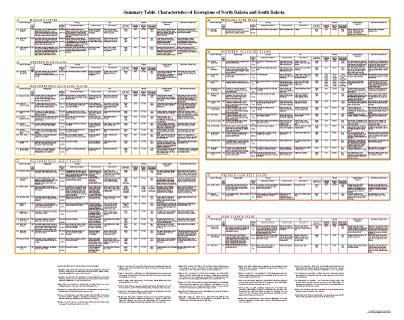
CITING THIS POSTER: Bryce, S.A., Omernik, J.M., Pater, D.A., Ulmer, M., Schaar, J., Freeouf, J., Johnson, R., Kuck, P., and Azevedo, S.H., 1996, Ecoregions of North Dakota and South Dakota, (color poster with map, descriptive text, summary tables, and photographs): Reston, Virginia, U.S. Geological Survey (map scale 1:1,500,000).
This project was partially supported by funds from the Environmental Protection Agency's Office of Research and Development, Regional Applied Research Effort (RARE) program.
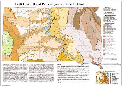
- South Dakota
GIS Data (shapefiles, metadata and symbology)
- South Dakota Level III Shapefile (303 kb)
- South Dakota Level III Metadata and South Dakota Level III Symbology
- South Dakota Level IV Shapefile (960 kb)
- South Dakota Level IV Metadata and South Dakota Level IV Symbology
- Instructions for applying symbology to ecoregions
Maps (available in PDF format)
- Level IV Ecoregions of North Dakota and South Dakota--poster front side 46" X 36" (4.8 mb)
- Level IV Ecoregions of North Dakota and South Dakota--poster back side 46" X 36" (536 kb)
- Level III and IV Ecoregions of North Dakota and South Dakota--24" X 27" (984 kb)
- Level III and IV Ecoregions of North Dakota and South Dakota--page size (1.1 mb)
- Level III and IV Ecoregions of South Dakota--30" X 23" (596 kb)
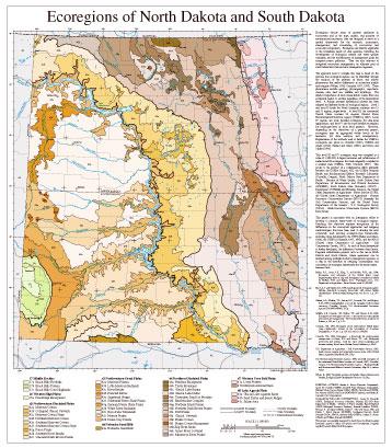
Ecoregions denote areas of general similarity in ecosystems and in the type, quality, and quantity of environmental resources; they are designed to serve as a spatial framework for the research, assessment, management, and monitoring of ecosystems and ecosystem components. Ecoregions are directly applicable to the immediate needs of state agencies, including the development of biological criteria and water quality standards, and the establishment of management goals for nonpoint-source pollution. They are also relevant to integrated ecosystem management, an ultimate goal of most federal and state resource management agencies.
The approach used to compile this map is based on the premise that ecological regions can be identified through the analysis of the patterns of biotic and abiotic phenomena that reflect differences in ecosystem quality and integrity (Wiken, 1986; Omernik, 1987, 1995). These phenomena include geology, physiography, vegetation, climate, soils, land use, wildlife, and hydrology. The relative importance of each characteristic varies from one ecological region to another regardless of the hierarchical level. A Roman numeral hierarchical scheme has been adopted for different levels of ecological regions. Level I and level II divide the North American continent into 15 and 51 regions, respectively. At level III, the continental United States contains 98 regions (United States Environmental Protection Agency [USEPA], 1996). Level IV regions are more detailed ecoregions for state-level applications; and level V are the most detailed ecoregions for landscape-level or local level projects. However, depending on the objectives of a particular project, ecoregions may be aggregated within levels of the hierarchy for data analysis and interpretation. Explanations of the methods used to define the USEPA's ecoregions are given in Omernik (1995), Griffith and others (1994), Gallant and others (1989), and Bryce and Clarke (1996).
This level III and IV ecoregion map was compiled at a scale of 1:250,000; it depicts revisions and subdivisions of earlier level III ecoregions that were originally compiled at a smaller scale (USEPA, 1996; Omernik, 1987). This poster is the product of a collaborative effort primarily between the USEPA Region VIII, the USEPA National Health and Environmental Effects Research Laboratory (Corvallis, Oregon), North Dakota State Department of Health - Division of Water Quality, South Dakota State Department of Environment and Natural Resources (SDDENR), South Dakota State University (SDSU) - Department of Wildlife and Fisheries Sciences, the United States Department of Agriculture - Forest Service (USFS), the United States Department of Agriculture - Natural Resources Conservation Service (NRCS) (formerly the Soil Conservation Service), and the United States Department of the Interior - U.S. Geological Survey (USGS) - Earth Resources Observation Systems (EROS) Data Center.
This project is associated with an interagency effort to develop a common frame-work of ecological regions. Reaching that objective requires recognition of the differences in the conceptual approaches and mapping methodologies that have been used to develop the most commonly used existing ecoregion-type frameworks, including those developed by the USFS (Bailey and others, 1994), the USEPA (Omernik, 1987, 1995), and the NRCS (United States Department of Agriculture - Soil Conservation Service, 1981). As each of these frameworks is further developed, the differences between them lessen. Regional collaborative projects such as this one in North Dakota and South Dakota, where agreement can be reached among multiple resource management agencies, is a step in the direction of attaining commonality and consistency in ecoregion frameworks for the entire nation.
Literature Cited:
Bailey, R.G., Avers, P.E., King, T., and McNab, W.H., eds., 1994, Ecoregions and subregions of the United States (map) (supplementary table of map unit descriptions compiled and edited by McNab, W.H. and Bailey, R.G.): Washington, D.C., U.S. Department of Agriculture - Forest Service, scale 1:7,500,000.Bryce, S.A. and Clarke, S.E., 1996, Landscape-level ecological regions: Linking state-level ecoregion frameworks with stream habitat classifications: Environmental Management, vol. 20, no. 3, p. 297-311.
Gallant, A.L., Whittier, T.R., Larsen, D.P., Omernik, J.M., and Hughes, R.M., 1989, Regionalization as a tool for managing environmental resources: Corvallis, Oregon, U.S. Environmental Protection Agency EPA/600/3-89/060, 152 p.
Griffith, G.E, Omernik, J.M., Wilton, T.F., and Pierson, S.M., 1994, Ecoregions and subregions of Iowa - a framework for water quality assessment and management: The Journal of the Iowa Academy of Science, v. 101, no. 1, p. 5-13.
Omernik, J.M., 1987, Ecoregions of the conterminous United States (map supplement): Annals of the Association of American Geographers, v. 77, no. 1, p. 118-125, scale 1:7,500,000.
Omernik, J.M., 1995, Ecoregions - a framework for environmental management, in Davis, W.S. and Simon, T.P., eds., Biological assessment and criteria - tools for water resource planning and decision making: Boca Raton, Florida, Lewis Publishers, p. 49-62.
U.S. Department of Agriculture - Soil Conservation Service, 1981, Land resource regions and major land resource areas of the United States: Agriculture Handbook 296, 156 p.
U.S. Environmental Protection Agency, 1996, Level III ecoregions of the continental United States (revision of Omernik, 1987): Corvallis, Oregon, U.S. Environmental Protection Agency - National Health and Environmental Effects Research Laboratory Map M-1, various scales.
Wiken, E., 1986, Terrestrial ecozones of Canada: Ottawa, Environment Canada, Ecological Land Classification Series no. 19, 26 p.
PRINCIPAL AUTHORS: Sandra A. Bryce (Dynamac Corporation), James M. Omernik (USEPA), David E. Pater (Dynamac Corporation), Michael Ulmer, Jerome Schaar (USDA, NRCS), Jerry Freeouf (USFS), Rex Johnson (SDSU), Pat Kuck (DENR/NRSC Liaison), and Sandra H. Azevedo (OAO Corporation).
COLLABORATORS AND CONTRIBUTORS: Lewis M. Cowardin (USGS, Biological Resources Division), Michael Ell (ND State Department of Health - Division of Water Quality), Harold Kantrud (USGS, Biological Resources Division), Kenneth Lindskov (USGS), Thomas R. Loveland (USGS), David J. Ode (SD Game, Fish and Parks), J. Foster Sawyer (SDDENR, Geological Survey), David Schmidt (USDA, NRCS), Anthony Selle (USEPA), Jeffery D. Stoner (USGS), and William Stewart (SDDENR).
CITING THIS POSTER: Bryce, S.A., Omernik, J.M., Pater, D.A., Ulmer, M., Schaar, J., Freeouf, J., Johnson, R., Kuck, P., and Azevedo, S.H., 1996, Ecoregions of North Dakota and South Dakota, (color poster with map, descriptive text, summary tables, and photographs): Reston, Virginia, U.S. Geological Survey (map scale 1:1,500,000).
This project was partially supported by funds from the Environmental Protection Agency's Office of Research and Development, Regional Applied Research Effort (RARE) program.
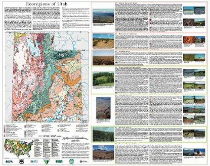
- Utah
GIS Data (shapefiles, metadata and symbology)
- Utah Level III Shapefile (290 kb)
- Utah Level III Metadata and Utah Level III Symbology
- Utah Level IV Shapefile (2.18 mb)
- Utah Level IV Metadata and Utah Level IV Symbology
- Instructions for applying symbology to ecoregions
Maps (available in PDF format)
- Level IV Ecoregions of Utah--poster front side 46" X 36" (5.8 mb)
- Level IV Ecoregions of Utah--poster back side 46" X 36" (1.8 mb)
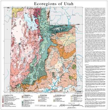
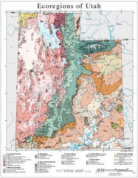
- Level III and IV Ecoregions of Utah--26" X 26" (1.7 mb)
- Level III and IV Ecoregions of Utah--page size (1.8 mb)
Ecoregions denote areas of general similarity in ecosystems and in the type, quality, and quantity of environmental resources; they are designed to serve as a spatial framework for the research, assessment, management, and monitoring of ecosystems and ecosystem components. Ecoregions are directly applicable to the immediate needs of state agencies, including the development of biological criteria and water quality standards and the establishment of management goals for nonpoint-source pollution. They are also relevant to integrated ecosystem management, an ultimate goal of most federal and state resource management agencies.
The approach used to compile this map is based on the premise that ecological regions can be identified through the analysis of the spatial patterns and the composition of biotic and abiotic phenomena that affect or reflect differences in ecosystem quality and integrity (Wiken 1986; Omernik 1987, 1995). These phenomena include geology, physiography, vegetation, climate, soils, land use, wildlife, and hydrology. The relative importance of each characteristic varies from one ecological region to another regardless of the hierarchical level. A Roman numeral hierarchical scheme has been adopted for different levels of ecological regions. Level I is the coarsest level, dividing North America into 15 ecological regions. Level II divides the continent into 52 regions (Commission for Environmental Cooperation Working Group 1997). At level III, the continental United States contains 104 ecoregions and the conterminous United States has 84 ecoregions (United States Environmental Protection Agency [USEPA] 2000). Level IV is a further subdivision of level III ecoregions. Explanations of the methods used to define the USEPA’s ecoregions are given in Omernik (1995), Griffith and others (1994), and Gallant and others (1989).
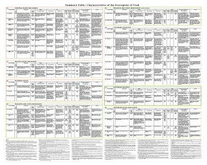
Utah is made up of arid deserts and canyonlands, salt flats, wetlands, semiarid shrublands, irrigated valleys, woodlands, forested mountains, and glaciated peaks. Ecological diversity is enormous. There are 7 level III ecoregions and 37 level IV ecoregions in Utah and most continue into ecologically similar parts of adjacent states. The level III and IV ecoregion map on this poster was compiled at a scale of 1:250,000 and depicts revisions and subdivisions of earlier level III ecoregions that were originally compiled at a smaller scale (USEPA 2000; Omernik 1987). This poster is part of a collaborative project primarily between USEPA Region VIII, USEPA National Health and Environmental Effects Research Laboratory (Corvallis, Oregon), Utah Department of Environmental Quality, Utah Division of Wildlife Resources, Utah Department of Natural Resources, United States Department of Agriculture-Forest Service (USFS), United States Department of Agriculture-Natural Resources Conservation Service (NRCS), United States Department of the Interior-Bureau of Land Management (BLM), and United States Department of the Interior-Geological Survey (USGS)-Earth Resources Observation Systems (EROS) Data Center.
The project is associated with an interagency effort to develop a common framework of ecological regions. Reaching that objective requires recognition of the differences in the conceptual approaches and mapping methodologies applied to develop the most common ecoregion-type frameworks, including those developed by the USFS (Bailey and others, 1994), the USEPA (Omernik 1987, 1995), and the NRCS (U.S. Department of Agriculture-Soil Conservation Service, 1981). As each of these frameworks is further refined, their differences are becoming less discernible. Regional collaborative projects such as this one in Utah, where agreement has been reached among multiple resource management agencies, is a step toward attaining consensus and consistency in ecoregion frameworks for the entire nation.
Literature Cited:
Bailey, R.G., Avers, P.E., King, T., and McNab, W.H., eds., 1994, Ecoregions and subregions of the United States (map) (supplementary table of map unit descriptions compiled and edited by McNab, W.H. and Bailey, R.G.): Washington, D.C., U.S. Department of Agriculture-Forest Service, scale 1:7,500,000.
Commission for Environmental Cooperation Working Group, 1997, Ecological regions of North America - toward a common perspective: Montreal, Quebec, Commission for Environmental Cooperation, 71 p.
Gallant, A.L., Whittier, T.R., Larsen, D.P., Omernik, J.M., and Hughes, R.M., 1989, Regionalization as a tool for managing environmental resources: Corvallis, Oregon, U.S. Environmental Protection Agency, EPA/600/3-89/060, 152 p.
Griffith, G.E., Omernik, J.M., Wilton, T.F., and Pierson, S.M., 1994, Ecoregions and subregions of Iowa - a framework for water quality assessment and management: The Journal of the Iowa Academy of Science, v. 101, no. 1, p. 5-13.
Omernik, J.M., 1987, Ecoregions of the conterminous United States (map supplement): Annals of the Association of American Geographers, v. 77, no. 1, p. 118-125, scale 1:7,500,000.
Omernik, J.M., 1995, Ecoregions - a framework for environmental management, in Davis, W.S. and Simon, T.P., eds., Biological assessment and criteria-tools for water resource planning and decision making: Boca Raton, Florida, Lewis Publishers, p. 49-62.
U.S. Department of Agriculture-Soil Conservation Service, 1981, Land resource regions and major land resource areas of the United States: Agriculture Handbook 296, 156 p.
U.S. Environmental Protection Agency, 2000, Level III ecoregions of the continental United States (revision of Omernik, 1987): Corvallis, Oregon, U.S. Environmental Protection Agency-National Health and Environmental Effects Research Laboratory, Map M-1, various scales.
Wiken, E., 1986, Terrestrial ecozones of Canada: Ottawa, Environment Canada, Ecological Land Classification Series no. 19, 26 p.
PRINCIPAL AUTHORS: Alan J. Woods (Dynamac Corporation), Duane A. Lammers (USFS), Sandra A. Bryce (Dynamac Corporation), James M. Omernik (USEPA), Richard L. Denton (Utah Division of Water Quality), Mike Domeier (NRCS), and Jeffrey A. Comstock (OAO Corporation).
COLLABORATORS AND CONTRIBUTORS: Tom Collins (USFS), Larry D. Ellicott (NRCS), Elise Giddings (USGS), Don Jensen (Climate Center, Utah State University), Nancy Keate (Utah Office of Planning and Budget), John Lott (USFS), Thomas R. Loveland (USGS), Larry Maxfield (BLM), Chad McGrath (NRCS), George Oliver (Utah Division of Wildlife Resources), Tony Selle (USEPA), Thor D. Thorson (NRCS), and Tom Toole (Utah Division of Water Quality).
REVIEWERS: Janis L. Boettinger (Utah State University), Joel Tuhy (The Nature Conservancy), and James H. Wheeler (Environmental Technology Office, West Desert Test Center, U.S. Army).
CITING THIS POSTER: Woods, A.J., Lammers, D.A., Bryce, S.A., Omernik, J.M., Denton, R.L., Domeier, M., and Comstock, J.A., 2001, Ecoregions of Utah (color poster with map, descriptive text, summary tables, and photographs): Reston, Virginia, U.S. Geological Survey (map scale 1:1,175,000).
This project was partially supported by funds from the USEPA-Office of Research and Development - Regional Applied Research Effort (RARE) program and USEPA-Office of Water, Biological Criteria Program.
- Wyoming
GIS Data (shapefiles, metadata and symbology)
Maps (available in PDF format)
- Level IV Ecoregions of Wyoming--poster front side 44.5" X 35.5" (11 mb)
- Level IV Ecoregions of Wyoming--poster back side 46" X 36" (612 kb)
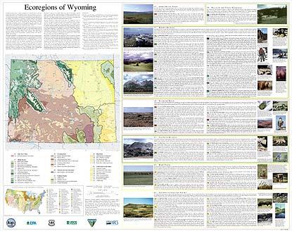
- Level III and IV Ecoregions of Wyoming--25" X 24" (424 kb)
- Level III and IV Ecoregions of Wyoming--page size (480 kb)
Ecoregions denote areas of general similarity in ecosystems and in the type, quality, and quantity of environmental resources; they are designed to serve as a spatial framework for the research, assessment, management, and monitoring of ecosystems and ecosystem components. By recognizing the spatial differences in the capacities and potentials of ecosystems, ecoregions stratify the environment by its probable response to disturbance (Bryce and others, 1999). These general purpose regions are critical for structuring and implementing ecosystem management strategies across federal agencies, state agencies, and nongovernment organizations that are responsible for different types of resources within the same geographical areas (Omernik and others, 2000).
The approach used to compile this map is based on the premise that ecological regions can be identified through the analysis of the spatial patterns and the composition of biotic and abiotic phenomena that affect or reflect differences in ecosystem quality and integrity (Wiken, 1986; Omernik, 1987, 1995). These phenomena include geology, physiography, vegetation, climate, soils, land use, wildlife, and hydrology.
The relative importance of each characteristic varies from one ecological region to another regardless of the hierarchical level. A Roman numeral hierarchical scheme has been adopted for different levels of ecological regions. Level I is the coarsest level, dividing North America into 15 ecological regions. Level II divides the continent into 52 regions (Commission for Environmental Cooperation Working Group, 1997). At level III, the continental United States contains 104 ecoregions and the conterminous United States has 84 ecoregions (United States Environmental Protection Agency [USEPA], 2003). Level IV is a further subdivision of level III ecoregions. Explanations of the methods used to define the USEPA’s ecoregions are given in Omernik (1995), Omernik and others (2000), Griffith and others (1994), and Gallant and others (1989).
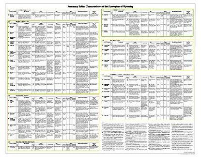
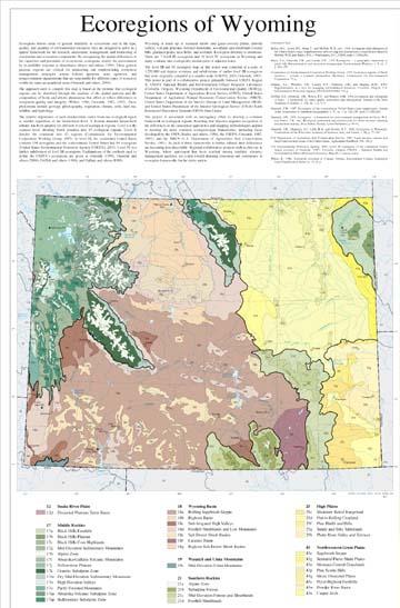
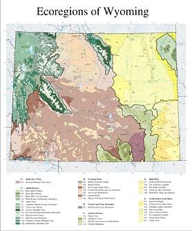
Wyoming is made up of semiarid shrub- and grass-covered plains, alluvial valleys, volcanic plateaus, forested mountains, woodland- and shrubland-covered hills, glaciated peaks, lava fields, and wetlands. Ecological diversity is enormous. There are 7 level III ecoregions and 39 level IV ecoregions in Wyoming and many continue into ecologically similar parts of adjacent states.
The level III and IV ecoregion map on this poster was compiled at a scale of 1:250,000 and depicts revisions and subdivisions of earlier level III ecoregions that were originally compiled at a smaller scale (USEPA, 2003; Omernik, 1987). This poster is part of a collaborative project primarily between USEPA Region X, USEPA National Health and Environmental Effects Research Laboratory (Corvallis, Oregon), Wyoming Department of Environmental Quality (WDEQ), United States Department of Agriculture–Forest Service (USFS), United States Department of Agriculture–Natural Resources Conservation Service (NRCS), United States Department of the Interior–Bureau of Land Management (BLM), and United States Department of the Interior–Geological Survey (USGS)–Earth Resources Observation Systems (EROS) Data Center.
The project is associated with an interagency effort to develop a common framework of ecological regions. Reaching that objective requires recognition of the differences in the conceptual approaches and mapping methodologies applied to develop the most common ecoregion-type frameworks, including those developed by the USFS (Bailey and others, 1994), the USEPA (Omernik, 1987, 1995), and the NRCS (U.S. Department of Agriculture–Soil Conservation Service, 1981). As each of these frameworks is further refined, their differences are becoming less discernible. Regional collaborative projects such as this one in Wyoming, where agreement has been reached among multiple resource management agencies, are a step toward attaining consensus and consistency in ecoregion frameworks for the entire nation.
Literature Cited:
Bailey, R.G., Avers, P.E., King, T., and McNab, W.H., eds., 1994, Ecoregions and subregions of the United States (map) (supplementary table of map unit descriptions compiled and edited by McNab, W.H. and Bailey, R.G.): Washington, D.C., USFS, scale 1:7,500,000.
Bryce, S.A., Omernik, J.M., and Larsen, D.P., 1999, Ecoregions – a geographic framework to guide risk characterization and ecosystem management: Environmental Practice, v. 1, no. 3, p. 141-155.
Commission for Environmental Cooperation Working Group, 1997, Ecological regions of North America – toward a common perspective: Montreal, Commission for Environmental Cooperation, 71 p.
Gallant, A.L., Whittier, T.R., Larsen, D.P., Omernik, J.M., and Hughes, R.M., 1989, Regionalization as a tool for managing environmental resources: Corvallis, Oregon, U.S. Environmental Protection Agency, EPA/600/3-89/060, 152 p.
Griffith, G.E., Omernik, J.M., Wilton, T.F., and Pierson, S.M., 1994, Ecoregions and subregions of Iowa – a framework for water quality assessment and management: Journal of the Iowa Academy of Science, v. 101, no. 1, p. 5-13.
Omernik, J.M., 1987, Ecoregions of the conterminous United States (map supplement): Annals of the Association of American Geographers, v. 77, no. 1, p. 118-125, scale 1:7,500,000.
Omernik, J.M., 1995, Ecoregions – a framework for environmental management, in Davis, W.S. and Simon, T.P., eds., Biological assessment and criteria-tools for water resource planning and decision making: Boca Raton, Florida, Lewis Publishers, p. 49-62.
Omernik, J.M., Chapman, S.S., Lillie, R.A., and Dumke, R.T., 2000, Ecoregions of Wisconsin: Transactions of the Wisconsin Academy of Sciences, Arts, and Letters, v. 88, p. 77-103.
U.S. Department of Agriculture–Soil Conservation Service, 1981, Land resource regions and major land resource areas of the United States: Agriculture Handbook 296, 156 p.
U.S. Environmental Protection Agency, 2003, Level III ecoregions of the continental United States (revision of Omernik, 1987): Corvallis, Oregon, USEPA – National Health and Environmental Effects Research Laboratory, Map M-1, various scales.
Wiken, E., 1986, Terrestrial ecozones of Canada: Ottawa, Environment Canada, Ecological Land Classification Series no. 19, 26 p.
PRINCIPAL AUTHORS: Shannen S. Chapman (Dynamac Corporation), Sandra A. Bryce (Dynamac Corporation), James M. Omernik (USEPA, retired), Donald G. Despain (USGS), Jeremy ZumBerge (WDEQ), and Mark Conrad (WDEQ).
COLLABORATORS AND CONTRIBUTORS: Dennis Knight (University of Wyoming), Tony Selle (USEPA), Jack Smith (WDEQ), Darrell Schroeder (NRCS), Bill Daniels (BLM), Tom Enright (BLM), Jerry Freeouf (USFS), and Jeffrey Comstock (Indus Corporation).
REVIEWERS: Kurt King (WDEQ) and Myron Brooks (USGS, Wyoming).
CITING THIS POSTER: Chapman, S.S., Bryce, S.A., Omernik, J.M., Despain, D.G., ZumBerge, J., and Conrad, M., 2004, Ecoregions of Wyoming (color poster with map, descriptive text, summary tables, and photographs): Reston, Virginia, U.S. Geological Survey (map scale 1:1,400,000).
This project was partially supported by funds from the USEPA– Office of Research and Development’s Environmental Monitoring and Assessment Program through contract 68-C6-005 to Dynamac Corporation.