Ecoregion Download Files by State - Region 9
Select a state for descriptive information about that state's Level III and IV ecoregions. Additionally, each state section contains links to downloadable maps in PDF format, and files containing GIS datasets (shapefiles, metadata, and symbology data).
Some Web content for Level IV Ecoregions is under construction. If you do not find a link to a state that has been completed, maps and GIS data are available on the Ecoregion FTP site and web content will be available shortly.
NOTE: maps and GIS files may differ. To make sure you are using the most current ecoregion data, download shapefiles of ecoregions.
- Arizona
GIS data (shapefiles, metadata and symbology)
- Arizona Level III Shapefile (530 kb)
- Arizona Level III Metadata and Arizona Level III Symbology
- Arizona Level IV Shapefile (2.5 mb)
- Arizona Level IV Metadata and Arizona Level IV Symbology
- Instructions for applying symbology to ecoregions
Maps (available in PDF format)
- Level III and IV Ecoregions of Arizona--poster front side 46" X 36" (25.9 mb)
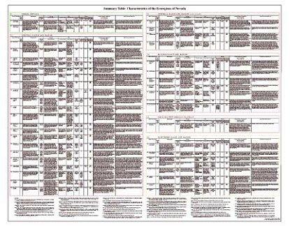
- Summary Table: Characteristics of Level IV Ecoregions of Arizona--poster back side 46" X 36" (310 kb)
- Level III and IV Ecoregions of Arizona--19" X 27.5" (9.6 mb)
- Level III Ecoregions of Arizona--page size 8.5"X 11"(5.8 mb)
Ecoregions denote areas of general similarity in ecosystems and in the type, quality, and quantity of environmental resources; they are designed to serve as a spatial framework for the research, assessment, management, and monitoring of ecosystems and ecosystem components. By recognizing the spatial differences in the capacities and potentials of ecosystems, ecoregions stratify the environment by its probable response to disturbance (Bryce and others, 1999). These general purpose regions are critical for structuring and implementing ecosystem management strategies across federal agencies, state agencies, and nongovernment organizations that are responsible for different types of resources within the same geographical areas (Omernik and others, 2000).
The Arizona ecoregion map was compiled at a scale of 1:250,000. It revises and subdivides an earlier national ecoregion map that was originally compiled at a smaller scale (United States Environmental Protection Agency [USEPA], 2013; Omernik, 1987). The approach used to compile this map is based on the premise that ecological regions can be identified through the analysis of the spatial patterns and the composition of biotic and abiotic phenomena that affect or reflect differences in ecosystem quality and integrity (Wiken, 1986; Omernik, 1987, 1995). These phenomena include geology, physiography, vegetation, climate, soils, land use, wildlife, and hydrology. The relative importance of each characteristic varies from one ecological region to another regardless of the hierarchical level.
A Roman numeral hierarchical scheme has been adopted for different levels of ecological regions. Level I is the coarsest level, dividing North America into 15 ecological regions. Level II divides the continent into 50 regions (Commission for Environmental Cooperation Working Group, 1997, map revised 2006). At level III, the continental United States contains 104 ecoregions and the conterminous United States has 85 ecoregions (USEPA, 2013). Level IV is a further subdivision of level III ecoregions. Explanations of the methods used to define the USEPA's ecoregions are given in Omernik (1995, 2004), Omernik and others (2000), and Gallant and others (1989).
Arizona contains arid deserts and canyonlands, semiarid shrub- and grass-covered plains, woodland- and shrubland-covered hills, lava fields and volcanic plateaus, forested mountains, glaciated peaks, and river alluvial floodplains. Ecological diversity is remarkably high. There are 7 level III ecoregions and 51 level IV ecoregions in Arizona and many continue into ecologically similar parts of adjacent states (Bryce and others, 2003; Chapman and others, 2006; Griffith and others, 2006, 2014; and Woods and others, 2001).
This poster is a collaborative project between the U.S. Geological Survey (USGS), USEPA National Health and Environmental Effects Research Laboratory (Corvallis, Oregon), USEPA Region IX, U.S. Department of Agriculture (USDA) - Natural Resources Conservation Service (NRCS), The Nature Conservancy, and several Arizona state agencies. The project is associated with an interagency effort to develop a common national framework of ecological regions (McMahon and others, 2001). Reaching that objective requires recognition of the differences in the conceptual approaches and mapping methodologies applied to develop the most common ecoregion-type frameworks, including those developed by the USDA - Forest Service (Bailey and others, 1994; Cleland and others, 2007), the USEPA (Omernik, 1987, 1995), and the NRCS (U.S. Department of Agriculture - Soil Conservation Service, 1981; U.S. Department of Agriculture - Natural Resources Conservation Service, 2006). As each of these frameworks is further refined, their differences are becoming less discernible. Collaborative ecoregion projects, such as this one in Arizona, are a step toward attaining consensus and consistency in ecoregion frameworks for the entire nation.
Literature Cited:
Bailey, R.G., Avers, P.E., King, T., and McNab, W.H., eds., 1994, Ecoregions and subregions of the United States (map) (supplementary table of map unit descriptions compiled and edited by McNab, W.H. and Bailey, R.G.): Washington, D.C., USFS, scale 1:7,500,000.
Bryce, S.A., Omernik, J.M., and Larsen, D.P., 1999, Ecoregions—a geographic framework to guide risk characterization and ecosystem management: Environmental Practice, v. 1, no. 3, p. 141-155.
Bryce, S.A., Woods, A.J., Morefield, J.D., Omernik, J.M., McKay, T.R., Brackley, G.K., Hall, R.K., Higgins, D.K., McMorran, D.C., Vargas, K.E., Petersen, E.B., Zamudio, D.C., and Comstock, J.A., 2003, Ecoregions of Nevada: Reston, Virginia, U.S. Geological Survey (map scale 1:1,350,000).
Chapman, S.S., Griffith, G.E., Omernik, J.M., Price, A.B., Freeouf, J., and Schrupp, D.L., 2006, Ecoregions of Colorado (color poster with map, descriptive text, and photographs): Reston, Virginia, U.S. Geological Survey (map scale 1:1,200,000).
Cleland, D.T., Freeouf, J.A., Keys, J.E., Jr., Nowacki, G.J., Carpenter, C., and McNab, W.H., 2007, Ecological subregions–sections and subsections of the conterminous United States: Washington, D.C., U.S. Department of Agriculture - Forest Service, General Technical Report WO-76, scale 1:3,500,000.
Commission for Environmental Cooperation Working Group, 1997, Ecological regions of North America–toward a common perspective: Montreal, Commission for Environmental Cooperation, 71 p.
Gallant, A.L., Whittier, T.R., Larsen, D.P., Omernik, J.M., and Hughes, R.M., 1989, Regionalization as a tool for managing environmental resources: Corvallis, Oregon, U.S. Environmental Protection Agency, EPA/600/3-89/060, 152 p.
Griffith, G.E., Omernik, J.M., McGraw, M.M., Jacobi, G.Z., Canavan, C.M., Schrader, T.S., Mercer, D., Hill, R., and Moran, B.C., 2006, Ecoregions of New Mexico (color poster with map, descriptive text, and photographs): Reston, Virginia, U.S. Geological Survey (map scale 1:1,400,000).
Griffith, G.E., Omernik, J.M., Smith, D.W., Cook, T.D., Tallyn, E., Moseley, K., and Johnson, C.B., 2014(in review), Ecoregions of California (poster): U.S. Geological Survey Open-File Report 2014-XXXX, with map, scale 1:1,100,000.
Omernik, J.M., 1987, Ecoregions of the conterminous United States (map supplement): Annals of the Association of American Geographers, v. 77, no. 1, p. 118-125, scale 1:7,500,000.
Omernik, J.M., 1995, Ecoregions—a framework for environmental management, in Davis, W.S. and Simon, T.P., eds., Biological assessment and criteria-tools for water resource planning and decision making: Boca Raton, Florida, Lewis Publishers, p. 49-62.
Omernik, J.M., 2004, Perspectives on the nature and definition of ecological regions: Environmental Management, v. 34, Supplement 1, p. s27-s38.
Omernik, J.M., Chapman, S.S., Lillie, R.A., and Dumke, R.T., 2000, Ecoregions of Wisconsin: Transactions of the Wisconsin Academy of Sciences, Arts, and Letters, v. 88, p. 77-103.
U.S. Department of Agriculture–Natural Resources Conservation Service, 2006, Land resource regions and major land resource areas of the United States, the Caribbean, and the Pacific Basin: Washington, D.C., U.S. Government Printing Office, Agriculture Handbook 296, 669 p. + map.
U.S. Department of Agriculture–Soil Conservation Service, 1981, Land resource regions and major land resource areas of the United States: Agriculture Handbook 296, 156 p.
U.S. Environmental Protection Agency, 2011, Level III ecoregions of the continental United States (revision of Omernik, 1987): Corvallis, Oregon, USEPA–National Health and Environmental Effects Research Laboratory, Map M-1, various scales.
Wiken, E., 1986, Terrestrial ecozones of Canada: Ottawa, Environment Canada, Ecological Land Classification Series no. 19, 26 p.
Woods, A.J., Lammers, D.A., Bryce, S.A., Omernik, J.M., Denton, R.L., Domeier, M., and Comstock, J.A., 2001, Ecoregions of Utah (color poster with map, descriptive text, and photographs): Reston, Virginia, U.S. Geological Survey (map scale 1:1,175,000).
PRINCIPAL AUTHORS: Glenn E. Griffith (USGS), James M. Omernik (USGS), Colleen Burch Johnson (Raytheon Corporation), and Dale S. Turner (TNC).
COLLABORATORS AND CONTRIBUTORS: John Spence (NPS), George Robertson (USFS), Barry Middleton (USGS), Sabra Schwartz (AZGFD), Glen Buettner (AZSF), Herman Garcia (NRCS), Lainie Levick (USDA-ARS), Sandy Bryce (Dynamac Corporation), Alan Woods (Oregon State University), Jim DeCoster (NPS), Patti Spindler (AZDEQ), Ryan Perkl (University of Arizona), Kristine Uhlman (University of Arizona), John Hutchinson (USGS), Jack Wittmann (USGS), Tony Olsen (USEPA), and Tom Loveland (USGS).
REVIEWERS: Jim Malusa (University of Arizona), Elroy Masters (BLM), and Tamara Wilson (USGS).
SUGGESTED CITATION: Griffith, G.E., Omernik, J.M., Johnson, C.B., and Turner, D.S., 2014, Ecoregions of Arizona (poster): U.S. Geological Survey Open-File Report 2014–1141, with map, scale 1:1,325,000, http://dx.doi.org/10.3133/ofr20141141.
- California
GIS data (shapefiles, metadata and symbology)
- California Level III Shapefile (530 kb)
- California Level III Metadata and California Level III Symbology
- California Level IV Shapefile (2.5 mb)
- California Level IV Metadata and California Level IV Symbology
- Instructions for applying symbology to ecoregions
Maps (available in PDF format)
- Ecoregions of California--poster front side (20.8 mb)
- Ecoregions of California--poster back side (1.3 mb)
Ecoregion Descriptions (MSWord documents)
Map Thumbnails 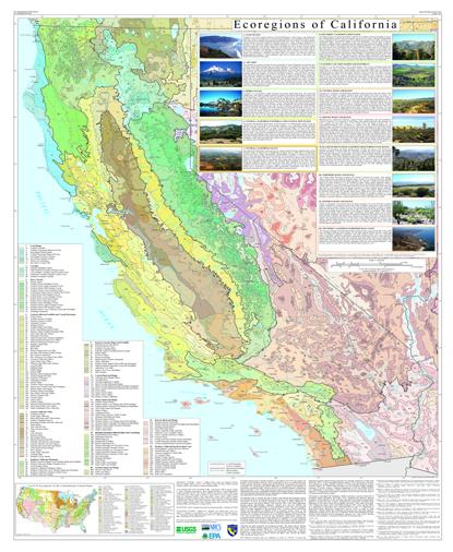 Ecoregions of California--poster front side (20.8 mb)
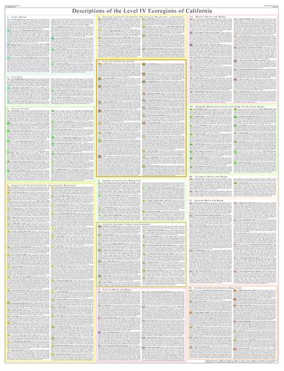 Ecoregions of California--poster back side (1.3 mb)
 - Nevada
GIS Data (shapefiles, metadata and symbology)
- Nevada Level III Shapefile (189 kb)
- Nevada Level III Metadata and Nevada Level III Symbology
- Nevada Level IV Shapefile (2.09 mb)
- Nevada Level IV Metadata and Nevada Level IV Symbology
- Instructions for applying symbology to ecoregions
Maps (available in PDF format)
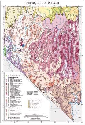
- Level IV Ecoregions of Nevada--poster front side 46" X 36" (4 mb)
- Level IV Ecoregions of Nevada--poster back side 46" X 36" (270 kb)
- Level III and IV Ecoregions of Nevada--24" X 26" (1.9 mb)
- Level III and IV Ecoregions of Nevada--page size (1.8 mb)
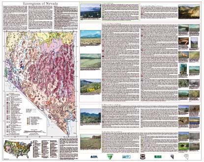
Ecoregions denote areas of general similarity in ecosystems and in the type, quality, and quantity of environmental resources. They are designed to serve as a spatial framework for the research, assessment, management, and monitoring of ecosystems and ecosystem components. By recognizing the spatial differences in the capacities and potentials of ecosystems, ecoregions stratify the environment by its probable response to disturbance (Bryce and others, 1999). Ecoregions are general purpose regions that are critical for structuring and implementing ecosystem management strategies across federal agencies, state agencies, and nongovernmental organizations that are responsible for different types of resources in the same geographical areas (Omernik and others, 2000).
The approach used to compile this map is based on the premise that ecological regions can be identi&Mac222;ed through the analysis of the spatial patterns and the composition of biotic and abiotic phenomena that affect or re&Mac223;ect differences in ecosystem quality and integrity (Wiken, 1986; Omernik, 1987, 1995). These phenomena include geology, physiography, vegetation, climate, soils, land use, wildlife, and hydrology. The relative importance of each phenomenon varies from one ecological region to another regardless of ecoregion hierarchical level. A Roman numeral hierarchical scheme has been adopted for different levels of ecological regions. Level I is the coarsest level, dividing North America into 15 ecological regions. Level II divides the continent into 52 regions (Commission for Environmental Cooperation Working Group, 1997). At level III, the continental United States contains 104 ecoregions and the conterminous United States has 84 ecoregions (U.S. Environmental Protection Agency [USEPA], 2002). Level IV is a further subdivision of level III ecoregions. Explanations of the methods used to de&Mac222;ne the USEPA’s ecoregions are given in Omernik (1995), Omernik and others (2000), Griffith and others (1994), and Gallant and others (1989).
Nevada’s physiography is composed of a repeating pattern of fault block mountains and intervening valleys. Valleys are shrub-covered or shrub- and grass-covered. Mountains may be brush-, woodland-, or forest-covered. Land use is primarily rangeland but many mines and large military reservations occur. Some valleys are irrigated and farmed, and rapid urban and suburban growth is occurring in the Las Vegas, Reno, and Carson City areas. Most of the state is internally drained and lies within the Great Basin; rivers in the southeast are part of the Colorado River system and those in the northeast drain to the Snake River. There are 5 level III ecoregions and 43 level IV ecoregions in Nevada and many continue into ecologically similar parts of adjacent states (McGrath and others, 2002; Woods and others, 2001).
The level III and IV ecoregion map on this poster was compiled at a scale of 1:250,000 and depicts revisions and subdivisions of earlier level III ecoregions that were originally compiled at a smaller scale (USEPA, 2002; Omernik, 1987). This poster is part of a collaborative project primarily between USEPA Region 9, USEPA National Health and Environmental Effects Research Laboratory (Corvallis, Oregon), Nevada Department of Conservation and Natural Resources–Division of Environmental Protection, Nevada Department of Conservation and Natural Resources–Nevada Natural Heritage Program, United States Department of Agriculture–Forest Service (USFS), United States Department of Agriculture–Natural Resources Conservation Service (NRCS), United States Department of the Interior–Bureau of Land Management (BLM), United States Department of the Interior–Fish and Wildlife Service, and United States Department of the Interior–Geological Survey (USGS)–Earth Resources Observation Systems (EROS) Data Center.
The Nevada ecoregion project is associated with an interagency effort to develop a common framework of ecological regions. Reaching that objective requires recognition of the differences in the conceptual approaches and mapping methodologies applied to develop the most common ecoregion-type frameworks, including those developed by the USFS (Bailey and others, 1994), the USEPA (Omernik, 1987, 1995), and the NRCS (U.S. Department of Agriculture–Soil Conservation Service, 1981). As each of these frameworks is further refined, their differences are becoming less discernible. Regional collaborative projects, such as this one in Nevada, where agreement has been reached among multiple resource management agencies, are a step toward attaining consensus and consistency in ecoregion frameworks for the entire nation.
Literature Cited:
Bailey, R.G., Avers, P.E., King, T., and McNab, W.H., eds., 1994, Ecoregions and subregions of the United States (map): Washington, D.C., USFS, scale 1:7,500,000.
Bryce, S.A., Omernik, J.M., and Larsen, D.P., 1999, Ecoregions—a geographic framework to guide risk characterization and ecosystem management: Environmental Practice, v. 1, no. 3, p. 141-155.
Commission for Environmental Cooperation Working Group, 1997, Ecological regions of North America—toward a common perspective: Montreal, Commission for Environmental Cooperation, 71 p.
Gallant, A.L., Whittier, T.R., Larsen, D.P., Omernik, J.M., and Hughes, R.M., 1989, Regionalization as a tool for managing environmental resources: Corvallis, Oregon, U.S. Environmental Protection Agency, EPA/600/3-89/060, 152 p.
Griffith, G.E., Omernik, J.M., Wilton, T.F., and Pierson, S.M., 1994, Ecoregions and subregions of Iowa – a framework for water quality assessment and management: Journal of the Iowa Academy of Science, v. 101, no. 1, p. 5-13.
J.A., Shelden, J., Crawford, R.C., Comstock, J.A., and Plocher, M.D., 2002, Ecoregions of Idaho: Reston, Virginia, U.S. Geological Survey (map scale 1:1,350,000).
McMahon, G., Gregonis, S.M., Waltman, S.W., Omernik, J.M., Thorson, T.D., Freeouf, J.A., Rorick, A.H., and Keys, J.E., 2001, Developing a spatial framework of common ecological regions for the conterminous United States: Environmental Management, v. 28, no. 3, p. 293-316.
Omernik, J.M., 1987, Ecoregions of the conterminous United States (map supplement): Annals of the Association of American Geographers, v. 77, p. 118-125, scale 1:7,500,000.
Omernik, J.M., 1995, Ecoregions—a framework for environmental management in Davis, W.S. and Simon, T.P., editors, Biological assessment and criteria-tools for water resource planning and decision making: Boca Raton, Florida, Lewis Publishers, p. 49-62.
Omernik, J.M., Chapman, S.S., Lillie, R.A., and Dumke, R.T., 2000, Ecoregions of Wisconsin: Transactions of the Wisconsin Academy of Sciences, Arts, and Letters, v. 88, p. 77-103.
U.S. Department of Agriculture–Soil Conservation Service, 1981, Land resource regions and major land resource areas of the United States: Agriculture Handbook 296, 156 p.
U.S. Environmental Protection Agency, 2002, Level III ecoregions of the continental United States (revision of Omernik, 1987): Corvallis, Oregon, USEPA–National Health and Environmental Effects Research Laboratory, Map M-1, various scales.
Wiken, E., 1986, Terrestrial ecozones of Canada: Ottawa, Environment Canada, Ecological Land Classification Series no. 19, 26 p.
Woods, A.J., Lammers, D.A., Bryce, S.A., Omernik, J.M., Denton, R.L., Domeier, M., and Comstock, J.A., 2001, Ecoregions of Utah: Reston, Virginia, U.S. Geological Survey (map scale 1:1,175,000).
PRINCIPAL AUTHORS: Sandra A. Bryce (Dynamac Corporation), Alan J. Woods (Dynamac Corporation), James D. More&Mac222;eld (Nevada Natural Heritage Program), James M. Omernik (USEPA), Thomas R. McKay (NRCS), Gary K. Brackley (NRCS), Robert K. Hall (USEPA), Damian K. Higgins (U.S. Fish and Wildlife Service), David C. McMorran (USFS), Karen E. Vargas (Nevada Division of Environmental Protection), Eric B. Petersen (Nevada Natural Heritage Program), Desiderio C. Zamudio (USFS), and Jeffrey A. Comstock (Indus Corporation).
COLLABORATORS AND CONTRIBUTORS: Bill Brooks (BLM), Robin Tausch (USFS–Rocky Mountain Research Station), and Bill W. Daily (NRCS).
REVIEWERS: Edgar F. Kleiner (Emeritus Professor, University of Nevada-Reno), Frederick F. Peterson (Emeritus Professor, University of Nevada-Reno), Harold Klieforth (Emeritus, Associate Research Meteorologist, Desert Research Institute), David Charlet (Professor, Community College of Southern Nevada), David A. Mouat (Associate Research Professor, Earth and Ecosystems Sciences, Desert Research Institute), Glenn Gentry (Supervisor, Water Quality Monitoring, Nevada Division of Environmental Protection), and Mark Warren (Staff Biologist, Nevada Division of Wildlife).
CITING THIS POSTER: Bryce, S.A., Woods, A.J., More&Mac222;eld, J.D., Omernik, J.M., McKay, T.R., Brackley, G.K., Hall, R.K., Higgins, D.K., McMorran, D.C., Vargas, K.E., Petersen, E.B., Zamudio, D.C., and Comstock, J.A., 2003, Ecoregions of Nevada (color poster with map, descriptive text, summary tables, and photographs): Reston, Virginia, U.S. Geological Survey (map scale 1:1,350,000).
This project was partially supported by funds from the USEPA– Of&Mac222;ce of Research and Development’s Environmental Monitoring and Assessment Program through contract 68-C6-005 to Dynamac Corporation.