Information about the Superfund Enforcement Cleanup Work Map

On this page:
Data Facts
In this section:
- About the mapped data
- Private party and federal entity Superfund site cleanup data
- Superfund enforcement data not represented on the map
- Other sources of information on cleanup activity on EPA's website
- Disclaimers
About the mapped data
The mapped data highlights current cleanup work at Superfund sites throughout the country as a result of the Agency’s enforcement work to negotiate cleanup settlement agreements or issue orders.
Private parties perform the cleanup work under administrative and judicial settlements and unilateral administrative orders. Cleanup work being performed under an order is only shown on the map if the party conducting the work has provided the Agency with a notice of intent to comply with the order. Cleanup work performed by federal government entities are governed by enforceable federal facility agreements.
Each site on the map indicates the National Priorities List (NPL) status. The NPL is the list of national priorities among the known releases or threatened releases of hazardous substances, pollutants, or contaminants throughout the United States and its territories. More information about NPL status and listing is available on the Agency's National Priorities List website.
The map presents data for sites, facilities, and properties, collected under the Comprehensive Environmental Response, Compensation, and Liability Act (CERCLA), as reported by the EPA Regions into Superfund Enterprise Management System (SEMS), the Agency’s comprehensive planning, tracking and reporting tool. More about SEMS. This map does not include data for state, local, or tribal funded cleanups.
Data points on the map are based on the primary or recently updated latitude and longitude ("lat/long") information in SEMS. In cases where the latitude and longitude information did not exist in SEMS, the lat/long information for the site was created using the LatLong.net website. Exit
To report a problem about the map or the data presented, use the "contact us" link on this page.
Private party and federal entity Superfund site cleanup data
The map contains the following data on the cleanup work conducted by private parties:
- Superfund site name (for sites where there appears to be an open work settlement or order requiring cleanup work),
- Site and EPA identification numbers
- Operable unit (OU)
- National Priorities List (NPL) status
- Site address
- Fiscal year
- Type of settlement or order and approval date
- Value of cleanup work to be done by the private parties and any applicable cost recovery amount
- Site type and subtype
- Parties who entered into cleanup agreements or who were issued cleanup orders, and
- Type of cleanup work to be performed (e.g., removal or remedial action or site investigation work).
For each site, the parties listed with the enforcement settlement or order are those parties who agreed to do the work under that agreement or order. In some cases, the party information associated with enforcement instruments at a site on the map was not available in the data system at the time of the data collection.
The map includes the following data on the cleanup work conducted by federal entities under a federal facility agreement (FFA) includes the following information:
- Superfund site name (for sites where there appears to be an open work settlement or order requiring cleanup work)
- Site and EPA identification numbers
- National Priorities List (NPL) status
- Site address
- Type of settlement or order and approval date
- Site type
- Party who entered into cleanup agreements or who were issued cleanup orders, and
- Agreement approval date.
Superfund enforcement data not represented on the map
The map does not depict all of the cleanup work being conducted across the country. There are many other sites where cleanup work is being performed by EPA, states, and tribes, and where the cost for the cleanup work is not financed through a cleanup settlement agreement, federal facility agreement, or order.
The map does not include sites where the work is currently being done by the EPA using money from the Superfund Trust Fund or money provided by Congress through general appropriations. Sites identified on the map with ongoing PRP cleanup work agreements may also have EPA-lead cleanup work going on at the same time. This information is not included on the map.
Other Superfund enforcement data for cleanup work currently being done that is not on the map includes:
- Sites where the work is currently being done by EPA using money from the Superfund Trust Fund or money provided by Congress through general appropriations. Note: Sites identified on the map can have EPA-lead cleanup work at the same time or in addition to the cleanup work being performed by the PRPs under cleanup agreements.
- Sites where a cleanup order was issued against a party or parties but a notice of intent to comply with the order has not been received by the Agency.
- Sites where the cleanup work being is being done under a state agreement.
- Sites where a settlement with a responsible party was only for cost recovery or a cashout agreement (i.e., one party pays for another party to perform the cleanup work).
Other sources of information on cleanup activity on EPA's website
Information about Superfund sites, cleanup activities, and enforcement efforts taking place across the country can be found at:
Search for Superfund Sites Where You Live
EPA's Superfund program maintains a database of all Superfund NPL sites, including proposed, final, and deleted NPL sites and non-NPL Superfund Alternative Approach sites. The database is searchable by region, state, and site name. The search results provide the user with a link to the Superfund site profile page for each individual site.
Cleanups in my Community (CIMC) enables a user to map and list hazardous waste cleanup locations and grant areas, and drill down to details about those cleanups and grants and other, related information. The site provides for expanded searching and mapping of cleanup work across the country under a variety of programs administered by EPA. CIMC does not currently contain the enforcement related data included in the Superfund Enforcement Cleanup Work map.
Disclaimers
- EPA is providing the information contained on this map for information purposes only. No warranty, express or implied, is made by EPA regarding the accuracy or completeness of this information. The relevant EPA Regional office may have additional site information.
- The data is not intended for use in calculating cost recovery or statutes of limitations, and cannot be relied upon to create any rights, substantive or procedural, enforceable by any party in litigation with the United States. EPA reserves the right to change these data at any time without public notice.
- >This map is updated annually. The data represents a “snapshot” in time (as of September 30, 2018) and does not reflect real time changes.
User Guide
In this section:
- Helpful Hints
- Map Navigation
- Search Capabilities
- Map Widgets
- How to Download Data from the Map Table
Helpful Hints
- Note that larger geographic search areas and more program types will cause the map to load more slowly.
- You may need to disable popup blockers in your browser.
- When searching by Superfund site name, you can use similar or exact, partial, or full name.
- The Superfund Enforcement Cleanup Work Map contains hundreds of data points for sites where work is currently being performed as a result of an enforcement settlement or order. Data points with darker coloration indicate either that:
- the site has multiple enforcement agreements or orders related to the ongoing cleanup work, or
- the geographic proximity of sites is producing a layering effect of sites on the map.
Map Navigation
You navigate the map by using your keyboard and mouse or the zoom controls located in the upper left corner of the screen.

Map Navigation Buttons
The navigation buttons are explained below in order from top-to-bottom based on the screenshot to the right:
- Use the Plus button to zoom in.
- Use the Minus button to zoom out.
- Use the Home button to zoom back to the initial extent of the map.
- Use the "My Location" button to zoom to your area based on the GPS of your device.
- View the overview map by clicking the "eye" button just below the location button.
Keyboard and Mouse Controls
- Use the [ + ] key to zoom in.
- Use the [ - ] key to zoom out.
- Zoom to an area by holding the shift key and drawing a rectangle while holding the left mouse button.
- Pan the map by holding the left mouse button and dragging the mouse in any direction.
- Center the map on a location by holding the shift key and clicking a location on the map.
Search Capabilities
There are multiple methods of searching the map:
- Search addresses or work location names using the search box at the top of the map (seen in the screenshot below)

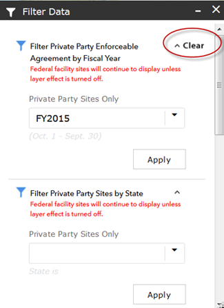
- Use the "Search Layers" widget at the bottom center of the map (grey funnel icon: ) to search information by:
- Fiscal year (private party sites only). Dropdown list provides selection of fiscal years
- State (both federal and private party sites)
- Enforceable agreement type (private party sites only). Dropdown list provides selection of enforceable agreement types.
- Type of cleanup work (private party sites only). Search results based on any term located within the "type of cleanup work" column of the map's attributes table.
- Click "Apply" for each filter
- The term "Clear" appears to indicate that the filter is active (see the screenshot below). Click on "Clear" to remove filter.
Map Widgets

![]() - Map Legend: This widget displays the symbology and the definitions for each layer on the map.
- Map Legend: This widget displays the symbology and the definitions for each layer on the map.
![]() - Map Layers: This widget displays the layers on the map and allows the user to turn off and on the layers with a checkbox.
- Map Layers: This widget displays the layers on the map and allows the user to turn off and on the layers with a checkbox.
![]() - Zoom to EPA Region: This widget displays a list of EPA Regions. When a region is selected, the map will zoom to display that region of the US.
- Zoom to EPA Region: This widget displays a list of EPA Regions. When a region is selected, the map will zoom to display that region of the US.
![]() - About The Map: This widget displays helpful information about how the map pop-ups work when clicking on map points.
- About The Map: This widget displays helpful information about how the map pop-ups work when clicking on map points.
- Search Layer: This widget is described in detail in the previous section of this guide: Search Capabilities.
![]() - Basemap Options: This widget displays a list of alternate basemaps that users can enable; changing the map background as desired.
- Basemap Options: This widget displays a list of alternate basemaps that users can enable; changing the map background as desired.
![]() - Map User Guide: This widget displays a brief summary about the map with a link to this full user guide.
- Map User Guide: This widget displays a brief summary about the map with a link to this full user guide.
![]() - Print Map: This widget allows users to print the map in different layouts and to different formats/sizes. It defaults to Map Only and PDF format but can be changed to suit the user's needs. Note: Map Only does not include legend or any other information; choose A3 Landscape to include the legend as well as a custom map title.
- Print Map: This widget allows users to print the map in different layouts and to different formats/sizes. It defaults to Map Only and PDF format but can be changed to suit the user's needs. Note: Map Only does not include legend or any other information; choose A3 Landscape to include the legend as well as a custom map title.
![]() - Open Attribute Table: This widget will open the attribute table from the bottom of the map. The attribute table displays the map information in a spreadsheet format. It can be resized and customized. The contents of the table change based on what the user is viewing on the map (i.e., if the user zooms into EPA's Region 1, then only Region 1 information will be displayed on the table).
- Open Attribute Table: This widget will open the attribute table from the bottom of the map. The attribute table displays the map information in a spreadsheet format. It can be resized and customized. The contents of the table change based on what the user is viewing on the map (i.e., if the user zooms into EPA's Region 1, then only Region 1 information will be displayed on the table).
How to Download Data from the Map Table
The attribute table can be customized using the options in the drop down shown in the below screenshot. Once the table is displaying the information desired by the user, it can be exported to a CSV format which is then saved to the user's computer and can be opened in Microsoft Excel.
