Ashtabula River AOC
Contact Us
Mary Beth Giancarlo
(giancarlo.marybeth@epa.gov)
312-886-2253
Overview
Beginning in the early 1800s, the lower Ashtabula River was widened and deepened to accommodate commercial shipping and shipbuilding. The shoreline was hardened to accommodate the growing industries. Today almost no natural riverbank habitat remains in the lower portion of the river. In the mid-1900s, chemical companies began operation along the Ashtabula River. Over time, the area became contaminated with mercury, chromium, lead, and zinc, as well as polychlorinated biphenyls (PCBs), polycyclic aromatic hydrocarbons (PAHs), chlorinated benzene compounds, chlorinated ethenes, hexachlorobutadiene, uranium, radium, and thorium. Fields Brook, a tributary that enters the river in the AOC, was designated as a Superfund site in 1983. The Fields Brook was a large source of contamination to the AOC. Due to this pollution and habitat loss, the Ashtabula River was designated as an AOC under the 1987 Great Lakes Water Quality Agreement.
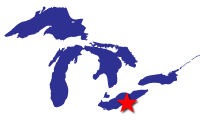
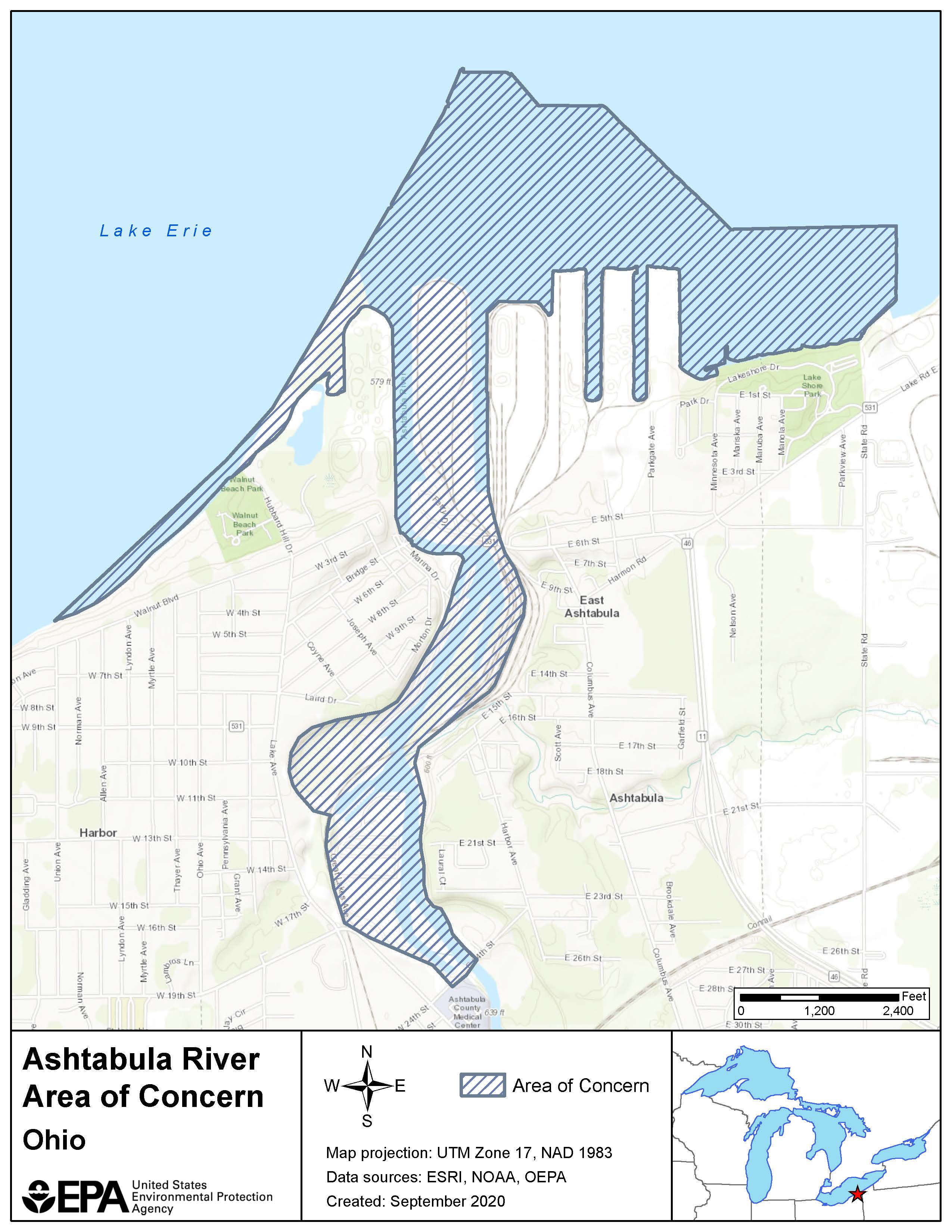
The Ashtabula River AOC encompasses the lower 2.32 miles of the Ashtabula River main stem, from the 24th Street Bridge in the City of Ashtabula to the mouth at Lake Erie; the Outer Harbor, within the east and west shore arms in Lake Erie; and the near Lake Erie shoreline from Walnut Beach, west of the river mouth, to Lakeshore Park Beach, east of the river mouth.
Beneficial Use Impairments
An interim success of remediation and restoration work is removing Beneficial Use Impairments (BUIs). BUIs are designations created by the International Joint Commission (IJC), representing different types of significant environmental degradation. As cleanup and restoration work is completed, and monitoring demonstrates BUI removal criteria have been met, BUIs can be removed.
The IJC identified 14 BUIs, which are specific categories of environmental degradation. The IJC identified 14 BUIs, which are specific categories of environmental degradation. Of 14 possible, six BUIs were identified for the Ashtabula River AOC. All six BUIs have been removed as of 2020. This means that Ohio can initiate the delisting process, which includes consultation with tribes, the IJC, and other federal agencies in addition to a public comment period. The list below shows when each BUI was removed. When all BUIs have been removed, Ohio can initiate the delisting process.
- Restrictions on Fish and Wildlife Consumption (PDF) - Removed 2014
- Degraded Fish and Wildlife Populations (PDF) - Removed 2014
- Loss of Fish and Wildlife Habitat (PDF) - Removed 2014
- Degradation of Benthos (PDF) - Removed 2018
- Restrictions on Dredging Activities - Removed 2020
- Fish Tumors or Other Deformities (PDF) - Removed 2020
- General information about BUIs: Beneficial Use Impairments for the Great Lakes AOCs
- BUI removal criteria are set locally. View the state of Ohio’s Delisting Guidance and Restoration Targets for Ohio Areas of Concern.
Remediation and Restoration Work
In 1988, the Ashtabula River Remedial Action Plan (RAP) Advisory Council was formed, and in 1991, Ohio EPA published the first RAP. A RAP develops a plan to cleanup and restore an AOC. In 2003, remediation actions at the nearby Fields Brook Superfund site, considered to be the main source of contamination to the AOC, were completed. More recently, all AOC remediation and restoration projects or management actions have been completed in the Ashtabula River AOC.
- Documents on Restoring Ashtabula River AOC
-
Remediation and Restoration Projects for Ashtabula River AOC
Highlighted Remediation and Restoration Projects
5 ½ Slip Restoration Effort
Funding from a Natural Resource Damage Assessment (NRDA) settlement, the Great Lakes Legacy Act (GLLA), and the Great Lakes Restoration Initiative (GLRI) combined to create 3840 linear feet of in-water habitat shelves and 3.6 acres of upland habitat on the peninsula. Native plants including pawpaw and dogwood were planted at the site.
The construction of the habitat shelves was necessary to remove two BUIs in the Ashtabula River AOC – Degraded Fish and Wildlife Populations and Loss of Fish and Wildlife Habitat. Even though excessive siltation from upstream blanketed the site, reducing the effectiveness of the shelves, the shelf structure and native plantings were ultimately effective in benefiting fish and wildlife habitat and populations.
Ashtabula River Sediment Cleanup
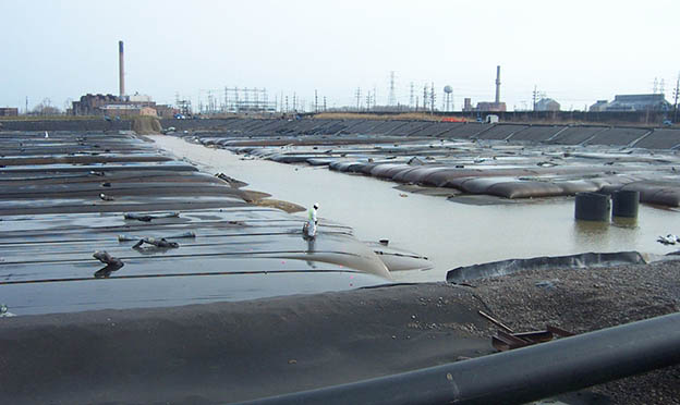
From 2006 to 2007, a GLLA project removed 497,000 cubic yards of polluted sediment from the Ashtabula River. A total of 25,000 pounds of PCBs were dredged from the river, along with low-level radioactive materials, heavy metals, and other pollutants.
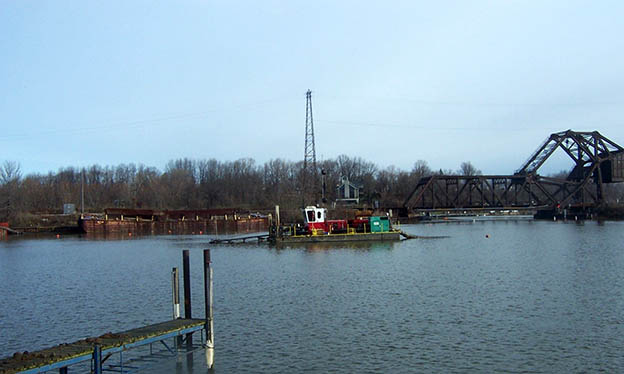
To get rid of the polluted sediment, project partners used hydraulic dredging to suction the sediment and remove it from the river. The sediment was moved offsite through a pipeline to a newly created Confined Disposal Facility (CDF) where it could be processed and contained safely. A sand cover was placed over the dredged areas in select locations to provide a clean sediment surface layer in the river.
The $57.6 million project was funded by the GLLA and the Ashtabula City Port Authority, with additional contributions from the Ohio EPA and the Ashtabula River Cooperation Group II, a group of private companies. This was the first project to be funded by a consortium of industries as cost-share partners. Fourteen industry partners make up the Ashtabula River Cooperation Group II.
This cleanup project not only removed contamination from the food chain, it also provided sufficient water depth for commercial and recreational boating on the Ashtabula River.
Partners
The following links exit the site Exit
Other Partners for the Ashtabula River
- Ashtabula River Cooperation Group II
- Remedial Action Plan Advisory Council