Buffalo River AOC


Contact Us
Mary Beth Giancarlo
(giancarlo.marybeth@epa.gov)
312-886-2253
Latest News
- Corps of Engineers Begins Buffalo Harbor DredgingExit
- Habitat Restoration Aids in Revitalization of Buffalo River
- Tainting of Fish and Wildlife Flavor BUI Removed 2020
Overview
Sources of potential pollution that caused impairments include:
Beneficial Use Impairments
BUIs are designations created by the International Joint Commission (IJC), representing different types of significant environmental degradation. Of 14 possible BUIs identified by the IJC, nine BUIs were identified for the Buffalo River AOC. As cleanup and restoration work is completed, and monitoring demonstrates BUI removal criteria have been met, BUIs can be removed. The removal of Beneficial Use Impairments (BUIs) is a good indication the environment is positively responding to the remediation and restoration work. Two of the nine BUIs have been removed at this AOC. Once all BUIs have been removed, the process of delisting the AOC can begin.
- Restrictions on Fish and Wildlife Consumption
- Tainting of Fish and Wildlife Flavor – Removed 2020
- Degradation of Fish and Wildlife Populations
- Fish Tumors or Other Deformities
- Bird or Animal Deformities or Reproduction Problems
- Degradation of Benthos
- Restrictions on Dredging Activities
- Degradation of Aesthetics – Removed 2018
- Loss of Fish and Wildlife Habitat
General information about BUIs: Beneficial Use Impairments for the Great Lakes AOCs
Remediation and Restoration Work
Remediation Project Highlight: Buffalo River GLLA Sediment Remediation and Aquatic Habitat Restoration
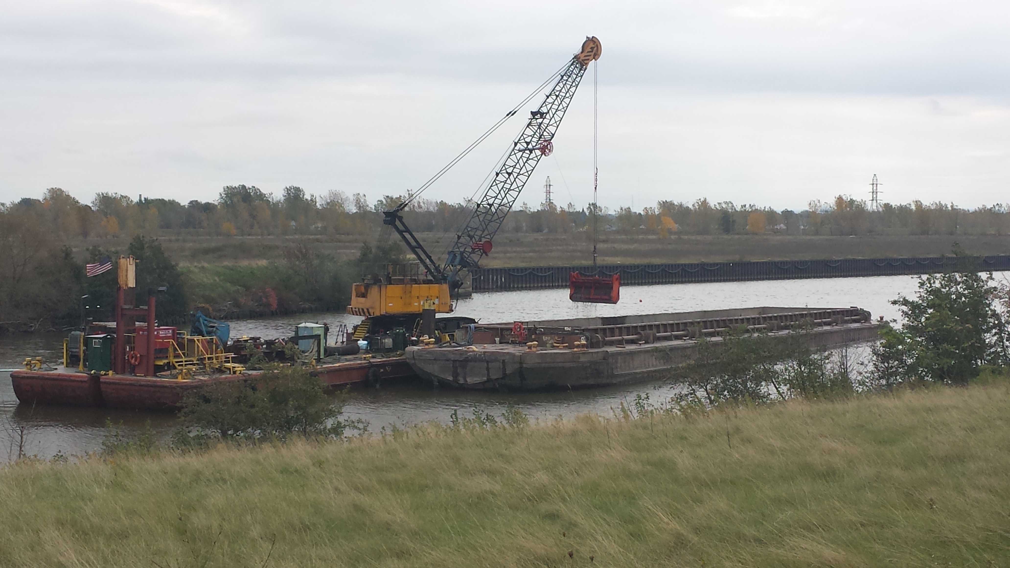 Mechanical dredging in the Buffalo River (Credit: Brian Murphy)Following the U.S. Army Corp of Engineers (USACE) dredging of contaminated sediment from the federal navigation channel, EPA dredged more than 450,000 cubic yards of PCB-, PAH-, and heavy metal-contaminated sediment from select areas within the Buffalo River and City Ship Canal. EPA dredging targeted the side slopes of the river and sediment located below the authorized dredge depth in the navigation channel to reduce exposure to contaminants during future maintenance dredging events. In addition, 65,000 cubic yards of clean capping material was placed over contaminated sediment at the end of the City Ship Canal. This 5-acre capped area is located outside of the navigation channel. This capped area provides the basis for the largest aquatic habitat restoration site for the project. Additionally, plants and habitat structures were also placed under water in the City Ship Canal and at four other locations to revitalize fish and wildlife populations in the river.
 These efforts addressed the BUIs below:
- Degradation of Benthos
- Loss of Fish and Wildlife Habitat
- Fish Tumors or Other Deformities
- Restrictions on Fish and Wildlife Consumption
- Restrictions on Dredging Activities
EPA has continually worked with federal, state and local partners to execute remediation and restoration work in the area with the ultimate goal of removing the AOC designation and revitalizing the surrounding communities.
Restoration Project Highlight: Erie County Pocket Parks Habitat Restoration
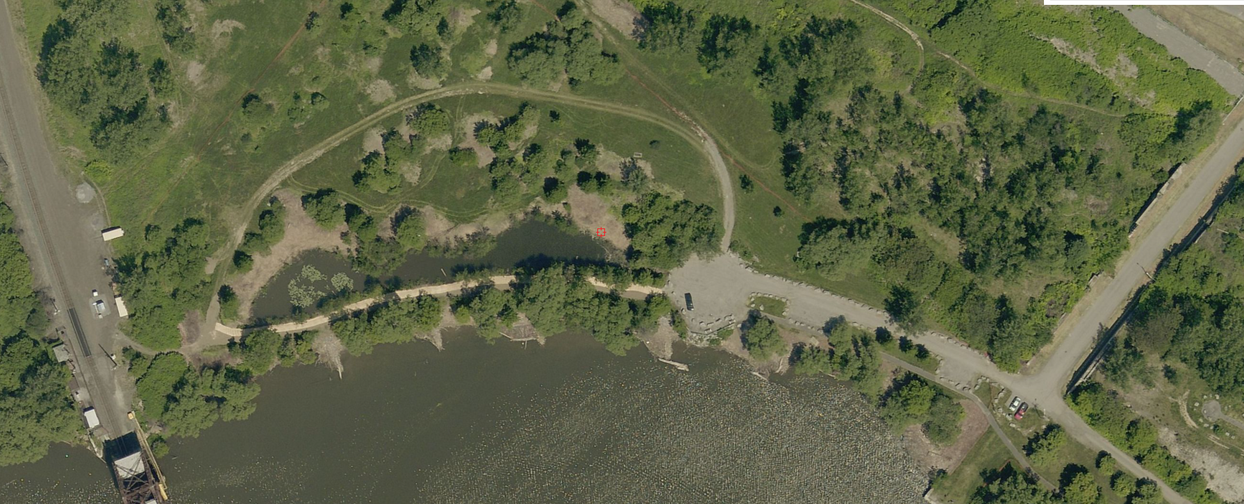 An aerial view of Red Jacket Habitat Park following successful habitat restoration (Credit: Erie County Environment and Planning)Habitat restoration projects took place at three Erie County ‘pocket parks.’ These parks were restored to provide habitat for fish and wildlife populations and increase recreational potential in urban areas across Erie County. The three parks that were restored include Thomas Higgins Natural Habitat Park, Red Jacket Natural Habitat Park, and the 61 Smith Street habitat area. GLRI provided more than $2.2 million in funding for these restoration projects.
Following the relocation of the Bailey Avenue Bridge, the Thomas Higgins Natural Habitat Park was restored. The park, which is located at the confluence of the Buffalo River and the Cazenovia Creek, is home to many native fish and wildlife populations. Restoration projects included the creation of a seiche wetland and an ephemeral pond, which holds water following snow melt and spring rains but is typically dry during summer months. Additionally, the planting of approximately eight trees, 40 shrubs, and 11,000 wildflowers helped jumpstart healthy habitat for wildlife populations, including turtles and waterfowl.
The Red Jacket Natural Habitat Park provides healthy habitat to fish and wildlife populations within the city. This popular fishing and hiking spot underwent habitat restoration in 2017. Projects included shoreline and near-shore restoration to improve habitat for fish and wildlife species. Green infrastructure near the parking area was enhanced to help mitigate erosion and contaminants from municipal runoff. A living fence consisting of densely growing hedges tight enough to provide edge habitat and prevent the intrusion of invasive species was planted around the perimeter of the park.
The 61 Smith Street habitat area is located on property owned by the Niagara Frontier Transportation Authority and is immediately adjacent to the Red Jacket Natural Habitat Park. The primary goal of this restoration was to increase the amount of healthy habitat areas for fish and wildlife populations. Projects to meet this goal included shoreline and near-shore habitat restoration. In order to preserve the area as a habitat sanctuary and limit recreational use of the area, no additional trails or green infrastructure projects were included.
- For more information on Erie County Parks Habitat Restoration projects, see Habitat RestorationExit and Buffalo River Area of Concern (AOC) – Erie County Habitat Restoration & Remedial Action Plan(40 pp, 2.7 MB)Exit
These efforts addressed the BUIs below:
- Degradation of Fish and Wildlife Populations
- Loss of Fish and Wildlife Habitat
Partners
The following links exit the site Exit
- National Oceanic and Atmospheric Administration (NOAA)
- U.S. Army Corps of Engineers, Buffalo District (USACE)
- U.S. Geological Survey (USGS)
- U.S. Fish and Wildlife Survey (USFW)
- U.S. Army Corps of Engineers, Buffalo District
- Buffalo Niagara WaterKeeper®
- Erie County
- Great Lakes Commission
- Honeywell
- New York State Department of Environmental Conservation