Clinton River AOC
Locate It

Contact Us
Susan Virgilio
(virgilio.susan@epa.gov)
312-886-4244
Overview
The Clinton River, one of the 31 U.S. based Areas of Concern (AOC), was designated as such under the 1987 Great Lakes Water Quality Agreement. The next year, in 1988, the river’s first Remedial Action Plan (RAP) document was completed; the RAP was most recently updated in 2014. It identifies the environmental impairments in the watershed, known as Beneficial Use Impairments (BUIs), and outlines projects to remove the impairments.
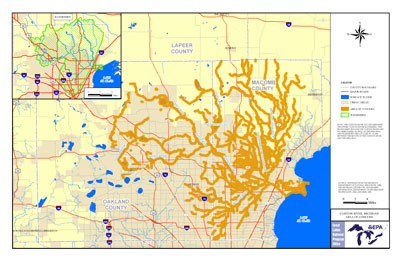
To date, the Great Lakes Restoration Initiative (GLRI) has provided more than $43 million to fund projects required to delist the Clinton River AOC. The river, located just north of Detroit in southeastern Michigan, drains 760 square miles of watershed. It flows 80 miles from near the city of Pontiac to Lake St. Clair near the city of Mt. Clemens. The Clinton River AOC encompasses the entire watershed and includes:
- The mainstem and its tributaries.
- The Spillway, a two-mile long canal that connects the Clinton River to Lake St. Clair.
- The nearshore area of Lake St. Clair between the Clinton River mouth and the Spillway outlet.
Urbanization in southeast Michigan contributed to the loss of open space and the discharge of pollutants from nonpoint and point sources. Ongoing contamination problems are mostly of nonpoint source origin. Pollutants that have historically impacted the AOC include:
- Heavy metals.
- Polychlorinated biphenyls (PCBs).
- Conventional pollutants including oil and grease, fecal coliform bacteria, nutrients, and total dissolved solids.
Federal, state, and local partners have identified and implemented projects that will contribute to the removal of BUIs and ultimate delisting of the AOC.
Beneficial Use Impairments
The International Joint Commission identified 14 BUIs, specific categories of environmental degradation, of which the Clinton River has 8. The RAP identifies projects and targets that need to be achieved for the BUI to be removed. Once each of the below BUIs have been removed, the process of delisting the AOC can begin.
- Restrictions on Fish and Wildlife Consumption
- Eutrophication or Undesirable Algae
- Degradation of Fish and Wildlife Populations
- Beach Closings
- Degradation of Aesthetics - Removed 2020
- Degradation of Benthos
- Restriction on Dredging Activities
- Loss of Fish and Wildlife Habitat
More information:
- General information about BUIs: Beneficial Use Impairments for the Great Lakes AOCs
- On delisting BUIs in AOCs within Michigan: Guidance for Delisting Michigan’s Great Lakes Areas of Concern (PDF) Exit
Remediation and Restoration Work
State and local partners, including the Clinton River Public Advisory Council, have identified the following projects that are necessary to remove the BUIs in the AOC:
- 18 habitat restoration projects, including invasive species control, dam removal, and wetland restoration. These projects address the Loss of Fish and Wildlife Habitat and Degradation of Fish and Wildlife Populations BUIs.
- 1 stream bank stabilization project at a former landfill site to address aesthetic concerns, thus addressing the Degradation of Aesthetics BUI.
- Potential sediment remediation project to address PCBs. This addresses the Restrictions on Dredging Activities BUI.
The 18 habitat restoration projects and the stream bank stabilization project have been completed or are expected to be completed by the end of 2020. Sediment evaluation is expected to be completed in 2020.
More information:
- Documents on Restoring the Clinton River AOC
- Remediation and Restoration Projects for Clinton River AOC
- For more information on this AOC, its Beneficial Use Impairments, and proposed restoration work, see Clinton River AOC FW Plan Addendum (PDF), ( 14 pp, 2 MB About PDF), 2014
Highlighted Habitat Restoration Work
- Clinton River Spillway Habitat Enhancement
- Lake St. Clair Coast Marsh Restoration
- Partridge Creek Commons Restoration
Clinton River Spillway Habitat Enhancement
The Macomb County Public Works Office completed work with GLRI funds to enhance the habitat for fish and wildlife in the Clinton River “Spillway” in 2019. The Spillway is a 2.5-mile-long, 80-foot-wide, man-made channel constructed by the U.S. Army Corps of Engineers in 1950 to provide flood control to the city of Mount Clemens, as well as to Clinton and Harrison townships in Michigan. The Spillway runs southeast from the overflow weir at Gratiot Avenue to Lake St. Clair. Both the Spillway and Lake St. Clair have fish communities that include emerald shiner, spottail shiner, largemouth bass, pumpkinseed sunfish, and brook silverside as predominant classes.
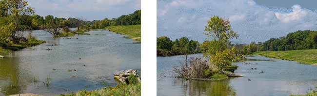 Two stable habitat areas created in the Clinton River Spillway. These areas contain repurposed sediment from the spillway and added vegetation takes up potential pollutants.
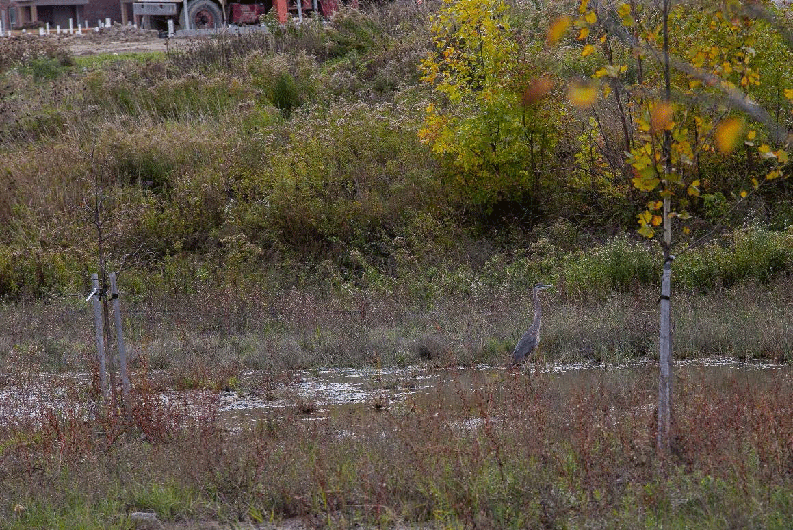
 New habitat area created in Clinton River Spillway, showing the presence of wildlife such as egrets and ducks.The GLRI funds were used to create diverse aquatic and terrestrial habitats. Fish spawning, rearing, and refuge habitats were enhanced though the excavation of floodplain shelves, the addition of gravel substrate, and the placement of wood structures. Woody debris and root wads provide habitat and resting areas for frogs, wading birds, turtles, ducks, and other native aquatic animals. Shallow water habitats in the excavated off-channel areas promote the growth of native cattail and other plants, and the newly created transition areas connect both riparian and floodplain areas to the channel. Plantings and invasive species control improved the density and diversity of native plant communities.
The goal of this project is to improve both the aquatic and terrestrial habitats of the Spillway, support robust populations of native wildlife, and make the area accessible and enjoyable to the surrounding communities. The project addresses the following BUIs:
- Degradation of Fish and Wildlife Populations.
- Loss of Fish & Wildlife Habitat.
- Degradation of Benthos.
Lake St. Clair Pointe Rosa Coastal Marsh Restoration
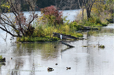
 Healthy habitat at Pointe Rosa Marsh in the Lake St. Clair Metroparks filters pollutants from the water and provides essential habitat for rare and threatened bird and reptile species. Credit: David Lewinski. Macomb County and the Huron-Clinton Metropark Authority were awarded GLRI funds to restore the Pointe Rosa Marsh area of the Lake St. Clair Metropark in Harrison Township, Mich. Shoreline development, invasive species and non-point source run-off have damaged or contributed to the loss of coastal marshes in the Clinton River AOC.
The Pointe Rosa Marsh restoration project was completed in 2013. The restored marsh acts as a natural filtration system for stormwater runoff to Lake St. Clair and provides critical habitat for turtles, invertebrates, and threatened or rare birds such as the least bittern, the marsh wren, and the Wilson’s snipe, which all rely on healthy marshland to survive. The restoration project also incorporates habitat structures for native wildlife species, such as the Eastern fox snake. Lastly, the project removed invasive phragmites, promoting conditions necessary to restore the plants native to the marsh community.
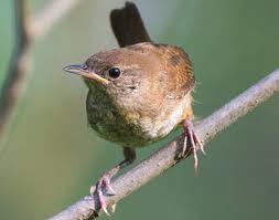 A marsh wren at Lake St. Clair Pointe Rosa Coastal Marsh, one of the species affected by damaged marshland. Credit: USFWS.These efforts address the BUIs below:
- Degradation of Fish and Wildlife Populations.
- Loss of Fish & Wildlife Habitat.
- Degradation of Benthos
More information:
On the St. Clair Coastal Marsh Restoration project, see Lake St. Clair Coastal Marsh Restoration.
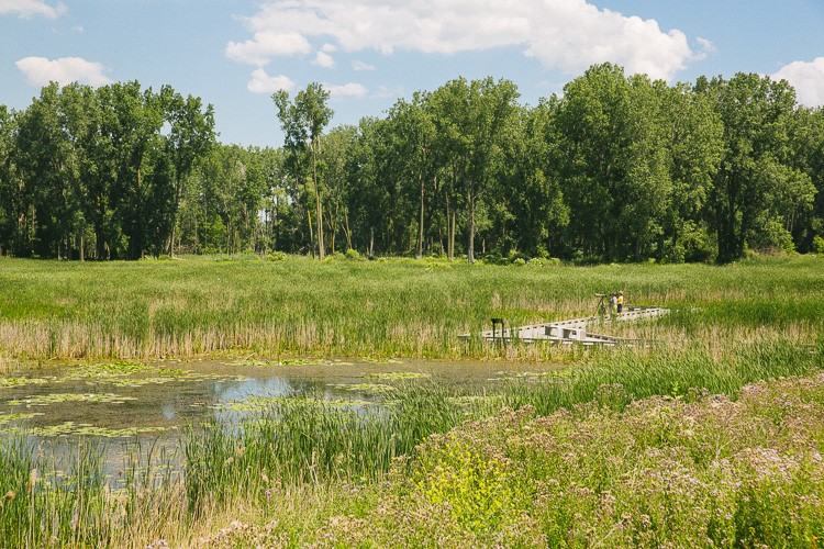
Partridge Creek Commons Restoration
Macomb County Public Works was awarded a GLRI grant to restore habitat in Gloede Drain, Partridge Creek Commons. The project was completed in 2019. The GLRI funding was used to treat invasive species, plant native vegetation, stabilize the eroding streambanks to reduce sedimentation, and create diverse in-stream, wetland, and upland habitats.
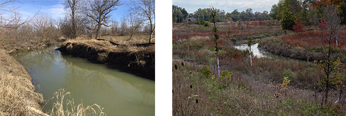 Before (left) and after (right) pictures of stream bank habitat and structure. The eroded streambanks were contributing to sedimentation in Partridge Creek. Streambanks were stabilized and structural and plant diversity was diverse added.
 Wildlife present in the pools created near the Partridge Creek streambank.These efforts address the BUIs below:
- Degradation of Fish and Wildlife Populations
- Loss of Fish & Wildlife Habitat
Overall, the project restored 44 acres of aquatic and associated terrestrial habitat including oxbows, wetlands, in addition to 5,500 linear feet of open channel habitat. Invasive species were removed in over 50 acres. Five acres of wetlands and 20 acres of oak opening, an area of oak trees in a turf of native grasses, were restored.
Partners
The following links exit the site Exit
- Clinton River Watershed Council
- Great Lakes Commission
- Huron-Clinton Metropark Authority
- Macomb County Drain Commissioner
- Macomb County Health Department
- Michigan Department of Environment, Great Lakes, and Energy (EGLE)
- Michigan Statewide Public Advisory Council
- Oakland County Water Resources Commission
- Oakland University