Cuyahoga River AOC

Contact Us
Mark Loomis
(loomis.mark@epa.gov)
312-886-0406
Overview
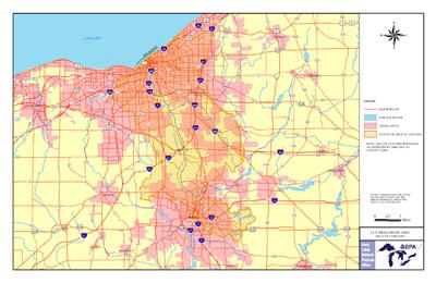
The Cuyahoga River is in northeastern Ohio and flows through Cleveland and into Lake Erie. The river drains over 800 square miles. The Cuyahoga River area became an Area of Concern in 1987 via the Great Lakes Water Quality Agreement.
The Cuyahoga AOC boundaries, established in 1988, originally included the lower 45 miles of the river from the Ohio Edison Gorge Dam at River Mile 45.1 in Cuyahoga Falls to the mouth of Lake Erie as well as approximately 10 miles of Lake Erie shoreline, from Edgewater Park on the west side of Cleveland to Wildwood Park on the east. The Cuyahoga River AOC includes drainage from Big Creek, West Creek, Mill Creek, Tinkers Creek, Sagamore Creek, Chippewa Creek, Brandywine Creek, Furnace Run, Yellow Creek, Sand Run, Mud Brook, Euclid Creek, Doan Brook, and Dugway-Ninemile-Green Creeks. These watersheds are within Cuyahoga, Lake, Medina and Summit counties. The AOC includes the Cuyahoga Valley National Park, which preserves 22 miles of river between the primary urban/industrial centers of Akron and Cleveland. On July 21, 2010, the upper AOC boundary was extended to River Mile 46.5, which encompasses the Gorge Dam pool and its sediments.
The Cuyahoga River watershed is degraded due to sediment and streambank erosion, water quality impacts from municipal and agricultural discharges, and historic contamination from urban and industrial sources. While urban stormwater runoff, combined sewer overflows and wastewater treatment plant bypasses are still in the process of being addressed, the overall water quality is starting to improve in the AOC. Already, the State of Ohio has worked to remove the beneficial use impairment for fish consumption in the AOC.
Work restoring the AOC continues, with a key focus on restoring habitat for fish and wildlife throughout the watershed. Habitat for fish and wildlife in the Area of Concern is impacted due to a loss of high-quality habitat, mainly from floodplains and riparian wetlands. Restoration efforts also target removal of first-barriers and dams that inhibit fish passage from Lake Erie into the Cuyahoga River. The last element of restoring habitat is through stream restoration. Stream restoration increases habitat diversity (riffles, pools, structure), while shoreline stabilization work reduces erosion and sedimentation. Collectively these many restoration efforts will create large-scale improvements to the overall fish and wildlife habitat in the AOC.
Cleanup and restoration in the Cuyahoga River AOC are important elements of protecting and enhancing habitat for fish and wildlife. Restoration of the river system is also important for the people who live in the many cities within its watershed. Restoring the river will help improve and enhance recreational opportunities and support regional communities who can benefit from having a cleaner river system and Great Lakes ecosystem.
Beneficial Use Impairments
An interim success of remediation and restoration work is removing Beneficial Use Impairments. Beneficial Use Impairments are designations given by the International Joint Commission representing different types of significant environmental degradation. As cleanup work is completed and monitoring demonstrates sufficient environmental health improvements, BUIs can be removed. The list below shows which BUIs have been removed and which remain. Once all BUIs are removed, the process of delisting the AOC can begin.
- Restrictions on Fish Consumption - Removed January 2019
- Degradation of Fish Populations
- Fish Tumors or Other Deformities
- Degradation of Benthos
- Restrictions on Navigational Dredging
- Eutrophication or Undesirable Algae
- Beach Closings (Recreational Contact)
- Degradation of Aesthetics - Removed November 2017
- Loss of Fish Habitat
- General information about BUIs: Beneficial Use Impairments for the Great Lakes AOCs
Remediation and Restoration Work
EPA has continually worked with federal, state and local partners to execute remediation and restoration work in the area. With enough environmental cleanup and restoration work, eventually the AOC designation can be removed.
- Documents on Restoring Cuyahoga River AOC
- Remediation and Restoration Projects for Cuyahoga River AOC
Highlighted Restoration Projects
Brecksville Canal Diversion Dam Removal
The Brecksville Dam, located in the Cuyahoga Valley National Park and the Cuyahoga River Area of Concern, has been removed in collaboration with local, state, and federal partners. The Brecksville Dam is also known as the Station Road Dam, Canal Diversion Dam, and State Route 82 Dam.
According to the National Park Service (NPS), the wooden Pinery Dam was built in 1827 to divert water from the Cuyahoga River into the Ohio & Erie Canal. The concrete Brecksville Dam was built in the 1950s to give water to industry in the area. Since dams impede fish migration, change water temperatures, and increase turbidity and sedimentation, both dams were removed in 2020 to improve the health of the river. Now that the dam has been removed, the Cuyahoga River is flowing freely, improving fish passage, reducing sedimentation, and enhancing paddling and recreation on this part of the Cuyahoga River.
In late May of 2020, the dam was “notched” – the first step in removing the dam. Notching allows water levels to be lowered in a controlled manner. After water levels were lowered the deconstruction process took place. This controlled deconstruction allowed the historic Pinery Dam to be uncovered and documented for historical records and cultural resource purposes. The dams were removed in early July. Next steps include creating modifications to the pumping system that will maintain water in the historic Ohio & Erie Canal.
Local stakeholders, State, and Federal agencies have made removing this dam a priority. The Great Lakes Restoration Initiative (GLRI) funded $800,000 of the project, and local and State sources also contributed $900,000. Now that the dam is removed, NPS and local groups will work to maintain water levels in the Ohio & Erie Canal. This way, water quality in the Cuyahoga can be improved while also preserving historic features in the Cuyahoga Valley National Park.
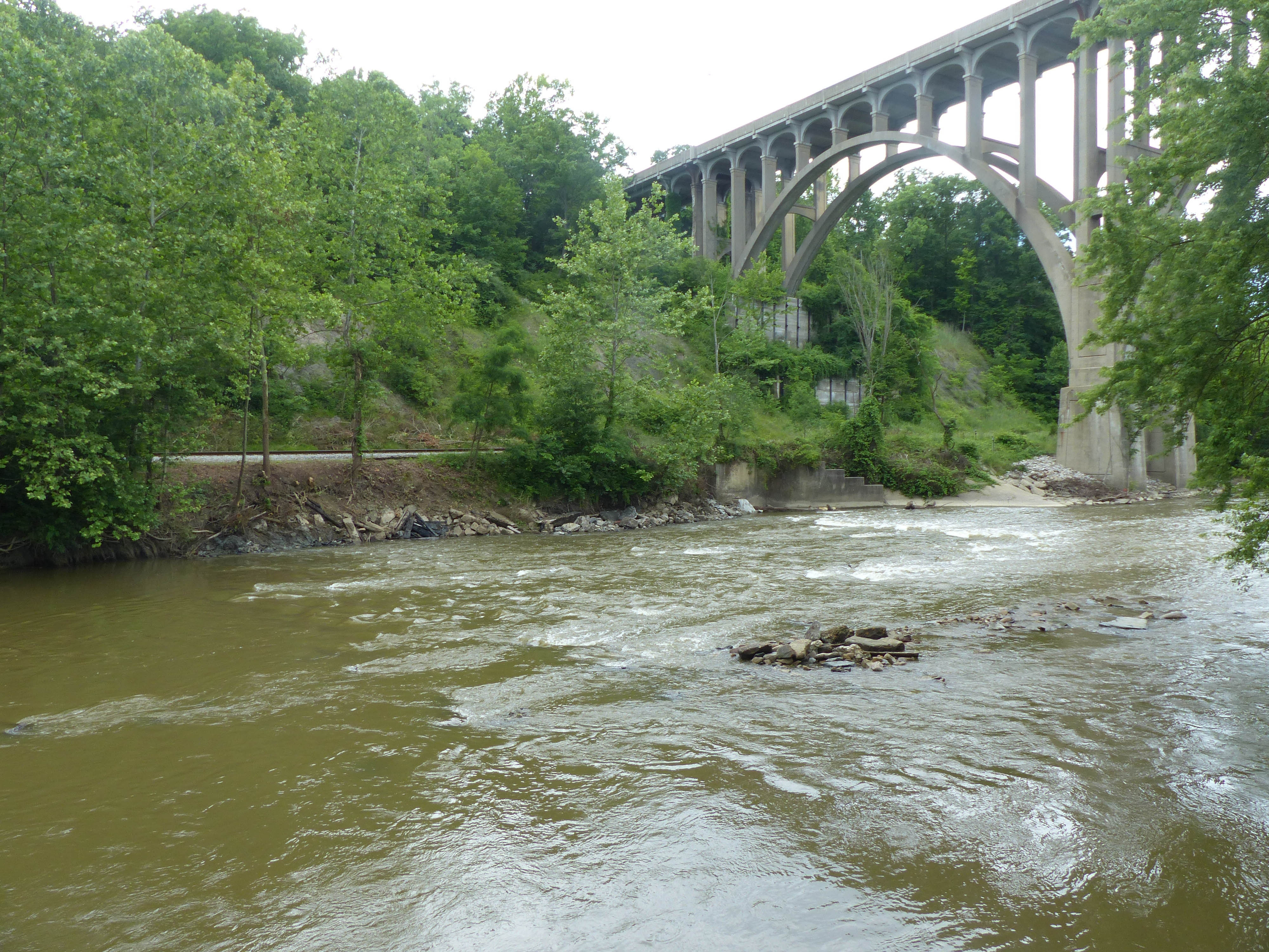 View looking west without dams (Day 35). View from Pinery Gate once Pinery Feeder Dam was removed (June 24, 2020). Photo credit: National Park Service/Arrye Rosser.
Cascade Valley View Habitat Restoration
Fish and wildlife will have access to restored habitat along the middle Cuyahoga River at Cascade Valley View, thanks to a partnership project between NOAA, the Great Lakes Commission (GLC), Summit Metro Parks, and GLRI. This project has nearly doubled the river’s capacity in the project area through floodplain restoration and removal of berms. The project installed natural stream features like rock-riffle structures, root-wads, and more natural bank modifications. Trees were planted on 50 acres of improved floodplain and along nearly a mile of the river.
Water quality here is improving, though there are still seven Beneficial Use Impairments (BUIs) in the Cuyahoga River AOC due to environmental damage. This project at Cascade Valley View will work to remove three of those BUIs- loss of fish and wildlife habitat, and degradation of fish and wildlife populations and degradation of benthos.
With the improvements here and the removal of the Gorge Dam, this section of the Cuyahoga River will once again be open to migratory Lake Erie fish, including steelhead, muskellunge, and walleye. Lake Sturgeon- an endangered fish in the state of Ohio- will once again have access to clean gravel substrates in these historical spawning sites and locations proposed for in-stream restoration. This project will not only benefit the environment and the fish and wildlife who make their habitat in Cascade Valley View, but it will also benefit the local economy and community with improved sport fishing, recreation, and shoreline safety. As conditions continue to improve and dams are removed, migratory fish including walleye, muskellunge, and steelhead will again have access to this part of the river.
This project was made possible through a strong partnership between federal, state, and local agencies. Project funding comes from NOAA through a Regional Partnership with GLC. Approximately $3.7M was provided through GLRI, and the project is managed locally by Summit Metro Parks. More information about the project can be found on the Great Lakes Commission website.
Partners
The following links exit the site Exit
- Cuyahoga River AOC
- Cuyahoga River Restoration
- Ohio EPA Lake Erie Programs
- Ohio EPA Cuyahoga River Watershed
- Pond Brook Watershed Initiative
Other Partners for the Cuyahoga River
- National Oceanic and Atmospheric Administration
- U.S. Army Corps of Engineers
- City of Akron
- City of Cuyahoga Falls
- Cleveland Metroparks
- Cuyahoga County Department of Public Works
- Cuyahoga County Soil & Water Conservation District
- Northeast Ohio Regional Sewer District
- Cuyahoga County Department of Public Works
- Northeast Ohio Four County Regional Planning and Development Organization (NEFCO)
- Ohio Department of Transportation (ODOT)
- Ohio Department of Natural Resources
- Ohio EPA
- Ohio Lake Erie Commission
- Ohio Sea Grant
- Summit MetroParks