Kalamazoo River AOC
Locate It

Contact Us
Sue Virgilio
(virgilio.susan@epa.gov)
312-886-1307
On This Page:
Latest News
- Native Species Return to a Fen Along the Kalamazoo River Exit
- State PFAS effort leads to improving water quality in Kalamazoo River Exit
Overview
The Kalamazoo River begins in Hillsdale County as a spring-fed pond and flows 175 miles west, eventually discharging into Lake Michigan near Saugatuck. The river’s watershed drains over 2,000 square miles of land in Michigan’s lower peninsula. The Kalamazoo region was historically home to an active paper mill industry. Much of the watershed’s current pollution is the result of de-inking operations at local paper mills. Prior to government regulation of polychlorinated biphenyl (PCBs), paper mills discharged the chemical into the river. PCBs are compounds that can build up in the sediments in rivers and lakes and bioaccumulate in the tissues of fish and other animals. In high concentrations, PCBs pose health risks to people who frequently eat fish and wildlife with high tissue concentrations.
The building of dams on the Kalamazoo River across the AOC have also contributed to PCB contamination. There has been a buildup of contaminated sediments behind dams, as they prevent the natural distribution of sediment and nutrients downstream. This not only exposes fish and wildlife populations to contaminants, but also limits the connectivity of habitat for populations.
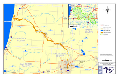
Due to this contamination, the river was designated as an Area of Concern under the 1987 Great Lakes Water Quality Agreement. It has also been identified as a site of environmental contamination under the Michigan Natural Resources and Environmental Protection Act 451 and is a designated Superfund site. Superfund is the federal government program that funds cleanup of sites contaminated with hazardous substances and pollutants. The AOC stretches a distance of around 80 miles and includes:
- The lower portion of the river from Morrow Dam in Kalamazoo County near Galesburg
- The mouth of the river in Allegan County at Saugatuck
- Three miles of Portage Creek from its confluence with the Kalamazoo River
Beneficial Use Impairments
Up to 14 Beneficial Use Impairments (BUIs) were designated at each AOC by the International Joint Commission (IJC) in 1987. Each BUI represents a distinct type of degradation that is detrimental to environmental and human health. A good indication of successful remediation and restoration work is the removal of BUIs. The Kalamazoo River AOC originally had 8 BUIs, and 2 have since been removed. BUIs can be removed once monitoring has determined that remediation and restoration work has sufficiently improved environmental health according to the standards set by each AOC’s Remedial Action Plan. Once all BUIs in an AOC have been removed, the EPA can begin the process of delisting the AOC.
- Restrictions on Fish and Wildlife Consumption
- Degradation of Fish and Wildlife Populations
- Beach Closings – Removed 2011
- Degradation of Aesthetics – Removed 2012
- Bird or Animal Deformities or Reproduction Problems
- Degradation of Benthos
- Restriction on Dredging Activities
- Loss of Fish and Wildlife Habitat
Remediation and Restoration Work
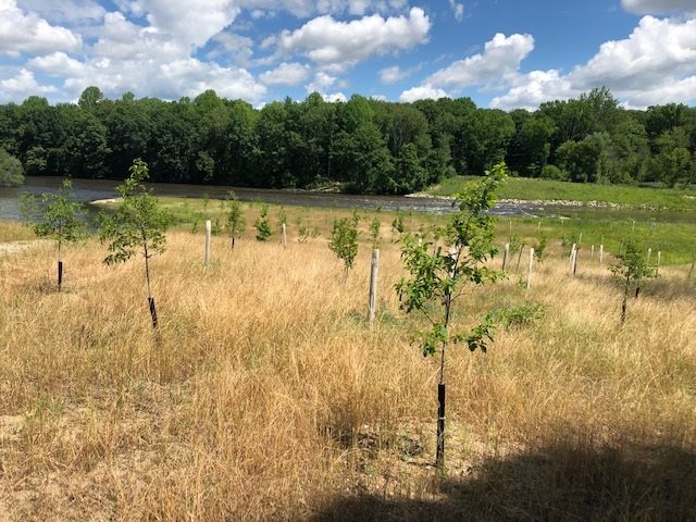 Plantings in the restored Otsego Township Dam Spillway floodplain.Remediation and Restoration work in the watershed will be implemented through the AOC program, Superfund Program, and Natural Resource Damages program. The local stakeholders have identified remediation of contaminated sediments, removal of dam structures and restoring natural stream processes as necessary to remove the remaining BUIs.
Removal of dam structures and stream restoration at the former dam locations are coordinated with Superfund sediment remediation projects and proposed for the following locations: Plainwell, Plainwell #2, Otsego City, Otsego Township, Trowbridge and Allegan. As a result of the dam removals, 47 linear miles of free-flowing river will be restored from Morrow Dam to Lake Allegan. The dam removals will provide spawning and feeding habitat for native fish populations. In addition, fish community diversity is expected to improve as in-water habitat is restored and larger sections of the river and its floodplain are once again connected.
Two habitat restoration projects have already been successfully completed, and five more are either ongoing or slated to begin in the next few years. These projects will help combat the development-related degradation and destruction of riparian and in-water habitats. The projects will also reconnect large sections of the river to its natural floodplain, increasing habitat area for populations such as river otters and bald eagles.
The Great Lakes Restoration Initiative (GLRI) has provided a total of $9.4 in funding for habitat restoration and dam removal projects to date.
Table of Remediation and Resoration Projects in the Kalamazoo River AOC
Restoration Project Highlight: Portage Creek Stream and Habitat Restoration
Portage Creek is a primary tributary into the Kalamazoo River. The creek flows through an industrialized urban area. Cement walls and steel fixtures have ‘hardened’ the shoreline, separating the creek from its natural floodplain.
The restoration of Portage Creek took place from 2010-2013. Deteriorating cement channel walls and dangerous piping and steel were removed from the banks of the creek. The banks were then returned to a more natural and gently sloping state, and riprap material was added to prevent erosion. Upland floodplain and in-water habitat areas were restored with native vegetation to increase habitat area for fish and wildlife populations. This also helped provide healthy habitat for bottom-dwelling benthic invertebrates, which are important for the creek’s food web.
A Superfund project was also completed in Portage Creek in 2012. Over 23,000 cubic yards of PCB-contaminated sediment and soil was removed from the upland floodplain area of the creek. The banks were then stabilized and restored to a more natural and gently sloping state that connects to the creek’s floodplain.
The creek was transformed from a dangerous eyesore to a healthy and vibrant community asset, increasing property values in the industrialized urban area. GLRI provided $3.3 million for the project, and local and state sources provided $530,000 in non-federal match.
For more information on the Portage Creek Stream and Habitat Restoration, see Michigan Areas of Concern: Kalamazoo Project Highlight (1 pp, 1.24 MB, About PDF)Exit
The sediment remediation and habitat restoration efforts addressed the BUIs below:
- Restrictions on Fish and Wildlife Consumption
- Degradation of Fish and Wildlife Populations
- Bird or Animal Deformities or Reproduction Problems
- Degradation of Benthos
- Loss of Fish and Wildlife Habitat
Restoration Project Highlight: Otsego Township Dam Spillway Removal and Habitat Restoration
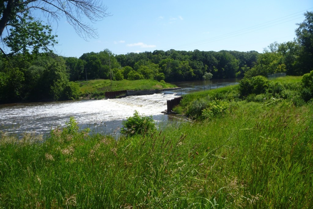 This is the location of a former powerhouse directly adjacent to the Otsego Township spillway. The Otsego Township Dam was built in the early 1900s to provide hydroelectric power to the area. The dam location was chosen on this location of the Kalamazoo River due to its rapid change in streambed elevation. The restriction of free-flowing water resulted in the buildup of PCB-contaminated sediment behind the dam. Prior to its removal, the dam had been deteriorating for years and was categorized as the highest possible risk of failure. In addition to the safety risk the dam posed to anglers and paddlers, if it failed then the accumulated sediment would have washed downstream and contaminated large stretches of the river.
In 2018, Superfund remediated the contaminated sediments in the impoundment above the dam and demolished the former dam powerhouse area while GLRI provided funds to remove the spillway and improve floodplain habitat.
Following the removal of the dam powerhouse area and spillway, the river was routed back to its original channel and the stream banks were stabilized. The floodplain was also restored at the spillway site and connected to the river again, providing habitat for native wildlife and plant species. The restoration of free-flowing water provides vital feeding and spawning habitat for fish in the area. It also allows for healthy sediment and nutrient transport, which helps mussel populations thrive.
The project increased the recreational value and safety of the river. Increased fish habitat provides better opportunities for anglers, and the removal of the dam in the steep-sloped section of the river provides fun and challenging rapids for paddlers.
The sediment remediation, dam removal and floodplain restoration addressed the BUIs below:
- Restrictions on Fish and Wildlife Consumption
- Degradation of Fish and Wildlife Populations
- Bird or Animal Deformities or Reproduction Problems
- Degradation of Benthos
- Loss of Fish and Wildlife Habitat
Documents
- Documents on Restoring Kalamazoo River AOC
- Kalamazoo River Superfund Project
- Kalamazoo River Natural Resource Damage Assessment conducted by the Trustees for the Kalamazoo River Watershed.
- PCB Cleanup to Begin Near Trowbridge Dam (2 pp, 636 K, About PDF)
- Stage 2 Remedial Action Plan Kalamazoo River Area of Concern (21 pp, 570 K, About PDF) EXIT
Partners
- National Oceanic and Atmospheric Administration (NOAA)
- US Fish and Wildlife Service (FWS)
- United States Geological Survey (USGS)
The following links exit the site Exi