Milwaukee Estuary AOC

Contact Us
Megan O’Brien
(OBrien.Megan@epa.gov)
312-353-3167
Latest News
Overview
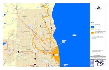
The Milwaukee Estuary is one of the 31 U.S.-based Areas of Concern (AOCs) across the Great Lakes created under the 1987 Great Lakes Water Quality Agreement. The original Milwaukee Estuary Area of Concern included: the lower 3.1 miles of the Milwaukee River downstream of North Avenue Dam; the lower 3 miles of the Menomonee River downstream of 35th Street; the lower 2.5 miles of the Kinnickinnic River downstream of Chase Avenue; and the inner and outer Harbor and nearshore waters of Lake Michigan, bounded by a line extending north from Sheridan Park in the city of Cudahy to the city of Milwaukee's Linnwood water treatment plant. In 2008, the boundary was expanded to include the following:
- Cedar Creek downstream from Bridge Road to confluence with Milwaukee River
- Milwaukee River and Lincoln Creek from confluence with Cedar Creek to North Avenue Dam
- Little Menomonee River from Brown Deer Road to confluence with Menomonee River, and Menomonee River downstream from confluence with Little Menomonee River to 35th Street
Historic activities throughout this predominantly industrial and urbanized watershed have resulted in pollution accumulation in the AOC. Pollution sources associated with land use from the drainage basin affect its water quality. The pollution comes from both point and nonpoint sources including: historic industrial discharges, wastewater treatment plants, combined sewer overflows, and agricultural and urban runoff. The primary contaminants in the Milwaukee Estuary AOC are Polychlorinated Biphenyls (PCBs), Polycyclic Aromatic Hydrocarbons (PAHs), and heavy metals.
Cleanup in this area is important to the Milwaukee economy and the communities that surround the estuary. Cleanup and restoration are vital to enhance recreational use of the estuary, thereby boosting tourism and community engagement.
Beneficial Use Impairments
An interim success of remediation (cleanup) and restoration work is removing Beneficial Use Impairments (BUIs). BUIs are designations given by the International Joint Commission, representing different types of significant environmental degradation. As cleanup work is completed, and monitoring demonstrates sufficient environmental health improvements, BUIs can be removed. There are 14 potential BUIs; 11 (listed below) were assigned to the Milwaukee Estuary AOC. Once all BUIs are removed, the process of delisting the AOC can begin.
- Restrictions on Fish and Wildlife Consumption.
- Eutrophication or Undesirable Algae.
- Degradation of Fish and Wildlife Populations.
- Beach Closings.
- Fish Tumors or Other Deformities.
- Degradation of Aesthetics.
- Bird or Animal Deformities or Reproduction Problems.
- Degradation of Benthos.
- Degradation of Phytoplankton and Zooplankton Populations.
- Restriction on Dredging Activities.
- Loss of Fish and Wildlife Habitat.
- General information about BUIs: Beneficial Use Impairments for the Great Lakes AOCs
Remediation and Restoration Work
EPA has continually worked with federal, state, and local partners to execute remediation and restoration work in the area with the goal of removing the AOC designation and thereby revitalizing the surrounding communities.
- Documents on Restoring Milwaukee Estuary AOC
- Remediation and Restoration Projects for Milwaukee Estuary AOC
Highlighted Projects
- Grand Trunk Wetland Restoration
- Estabrook Dam Fish Passage
- Lincoln Creek and Milwaukee River Channel Legacy Act Cleanup
Grand Trunk Wetland Restoration
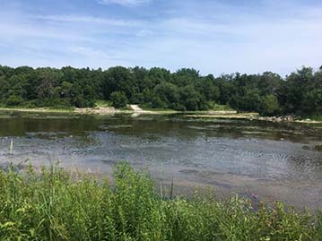
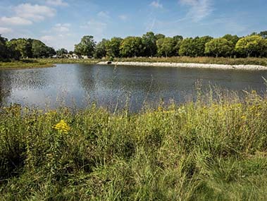
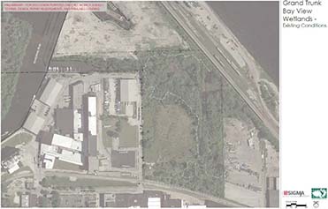 The Grand Trunk Wetland is located at 1980 S. Marina Drive and 632 E. Bay St. in Milwaukee’s inner harbor.
The Wisconsin Department of Natural Resources (WDNR) received Great Lakes Restoration Initiative (GLRI) funding to restore the Grand Trunk wetland. The project is estimated to be completed in 2021. Historically, the Grand Trunk Wetland was an extensive freshwater marsh, providing refuge for fish and wildlife alike. Today, through continued industrial land use, the system has become highly degraded. As the largest and one of the last remaining wetlands in the Kinnickinnic watershed, restoration is vital to the health of the river. The Grand Trunk Wetland enhancement project will connect the channel and eastern wetland area — a seiche wetland — for fish spawning; restore sand dune and meadow habitats; and restore an amphibian pond. The project will also remediate contaminated soil and replant native flora species.
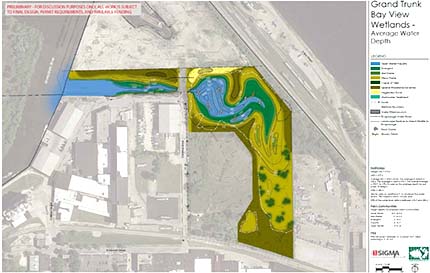 The tentative design plan for the Grand Trunk Wetland restoration features a restored stream channel to provide a connection between the channel and eastern wetland area.
Restoration of this wetland will address the Loss of Fish and Wildlife Habitat BUI and will be an important step in greening the harbor area. Restoration of this wetland can allow recreational activities such as canoeing and kayaking and a visitor center with walking trails to be established. This restored site can hopefully play an important role in boosting community assets and promoting tourism to the area.
Estabrook Dam Fish Passage
 This project opened and connected 25 miles of the Milwaukee River, 29 miles of tributary stream, and over 2,400 acres of wetland spawning and nursery habitats.
The Milwaukee Metropolitan Sewerage District (MMSD) in partnership with WDNR received GLRI and Fund for Lake Michigan (FFLM) money to remove the Estabrook Dam. The dam was initially constructed in the 1930s for recreational purposes but was removed to allow fish access to upstream spawning and nursery habitats, increasing their availability to the lake and estuary. By removing the dam, a critical link to habitat in the upstream portions of Milwaukee River watershed was re-established.
 Estabrook Dam is the farthest downstream aquatic organism passage barrier on the Milwaukee River.
This project, along with another GLRI/FFLM-funded AOC fish passage endeavor, opened and connected 25 miles of the Milwaukee River, 29 miles of tributary stream, and over 2,400 acres of wetland spawning and nursery habitats. The removal of the Estabrook Dam is an important aspect in connecting habitats within the Milwaukee River thereby protecting the aquatic species and other wildlife that inhabit it.
Video on the Estabrook Dam Fish Passage ProjectExit
Lincoln Creek and Milwaukee River Channel Legacy Act Cleanup
 This project played an important role in helping to restore the waters, wildlife, and communities of the Milwaukee Estuary. The Wisconsin Department of Natural Resources, the Milwaukee County Parks, and EPA began working on this Great Lakes Legacy Act Cleanup project in 2008 in order to remove contaminated sediment within the Lincoln Park/Milwaukee River channels. The project began with a site characterization and feasibility study to select a cleanup plan for the area. The project was divided into two phases. The first phase included the Lincoln Creek area from Green Bay Avenue and the Western Oxbow of the Milwaukee River. The second phase included the Milwaukee River from the railroad bridge north of the park, down to the Estabrook Dam fixed crest spillway and the Eastern Oxbow of the river.
In 2012, almost 119,039 cubic yards of contaminated sediment were removed during phase one of the project. Sediment contained PCBs and PAHs that cause damage to human, environmental, and wildlife health. Upon removal of the contaminated sediment, the habitat was then restored in order to improve the water quality and benefit local fish and wildlife populations.
 Workers removed 119,039 cubic yards of contaminated sediment during phase I of the project and 52,456 cubic yards during phase II.Phase two of the project, occuring 2014-2015, removed 52,456 cubic yards of contaminated sediment and restored 1.62 acres of wetland habitat. Monitoring was also conducted to ensure the continued health of the waters of the Milwaukee Estuary. This project helps to remove the BUIs of Restrictions on Fish and Wildlife Consumption, Degradation of Fish and Wildlife Populations, Fish Tumors or Other Deformities, Degradation of Benthos, Restriction on Dredging Activities, and Loss of Fish and Wildlife Habitat.
Partners
The following links exit the site Exi