Since 2015, the U.S. EPA and industrial partners have been working on completing a remedial design to remove contaminated sediments from Otter Creek in Oregon, Ohio. The lower 1.7 miles of Otter Creek and its confluence area within Maumee Bay consist of contaminated sediments with elevated levels of polycyclic aromatic hydrocarbons (PAH) and diesel range organics (DRO). Approximately 57,000 cubic yards of contaminated sediment will be removed from the creek and its confluence within Maumee Bay. Construction activities will begin in late 2020 and completion is expected in late 2021.
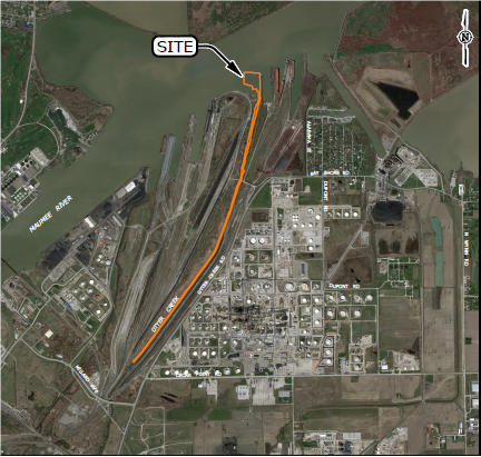 Otter Creek: Remedial area includes approximately 1.7 miles of Otter Creek and a portion of the confluence area within Maumee Bay.
About the Site
The section of Otter Creek that will be remediated is located in a highly industrial area which includes an active railroad yard. It encompasses the lower 1.7 miles of the creek, starting from the mouth and extending upstream to the Millard Avenue Bridge. Sediment investigations determined that these chemicals of concern are bioavailable to the benthic community and that the most effective way to reduce risk is to remove the contaminated sediment.
The Clean Up Plan
Sediment will be removed by hydraulically dredging the creek to a depth of 4 feet or to native clay (whichever is first). Dredge depths were determined through extensive sediment testing and investigations in order to develop a plan for each specific section of the creek. The sediment dredged from the creek will be pumped through a pipeline to the nearby Toledo-Lucas County Port Authority’s confined disposal facility (CDF) where it will remain indefinitely. Similarly, parts of the confluence will be hydraulically dredged from depths ranging from 1 to 5.5 feet depending on contamination and will be transported to the CDF by pipeline.
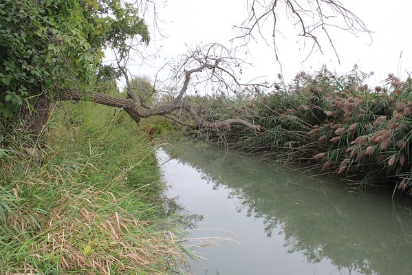 Otter Creek is a narrow waterway with limited access, surrounded by industry.A one-foot sand cover will be placed in the creek immediately after dredging to provide a clean substrate for benthic organisms to utilize when re-establishing community populations. Habitat improvements such as rootwads and/or lock-logged structures will be placed throughout the project area to further enhance the post-remediation conditions for both benthic organisms and fish.
This approximately $12.1M project agreement is cost-shared between three industrial partners and EPA, with funding from the Great Lakes Restoration Initiative (GLRI). This project also involves tremendous support and coordination from multiple stakeholders such as: city of Oregon, Toledo-Lucas County Port Authority, Ohio EPA, U.S. Fish and Wildlife Service and U.S. Army Corps of Engineers.
You may need a PDF reader to view some of the files on this page. See EPA’s About PDF page to learn more.- Final Focused Feasibility Study Duck and Otter Creeks (PDF)(234 pp, 11 MB, January 2017)
- Supplemental Data Evaluation for Duck and Otter Creek, Appendix A (PDF)(234 pp, 17 MB, August 2013)
- Final Focused Feasibility Study Duck Otter Creek (PDF)(72 pp, 19 MB, February 2013)
- Duck and Otter Creeks Great Lakes Legacy Act Data Gap Investigation Report (PDF)(138 pp, 7 MB, April 2012)