Rouge River AOC
Locate It

Contact Us
Rose Ellison
(ellison.rosanne@epa.gov)
734-692-7689
Latest News
- EPA announces $4.2 million for habitat restoration work at Rouge River Area of Concern
- EPA announces over $1.8 million for habitat restoration work at Rouge River Area of Concern
Overview
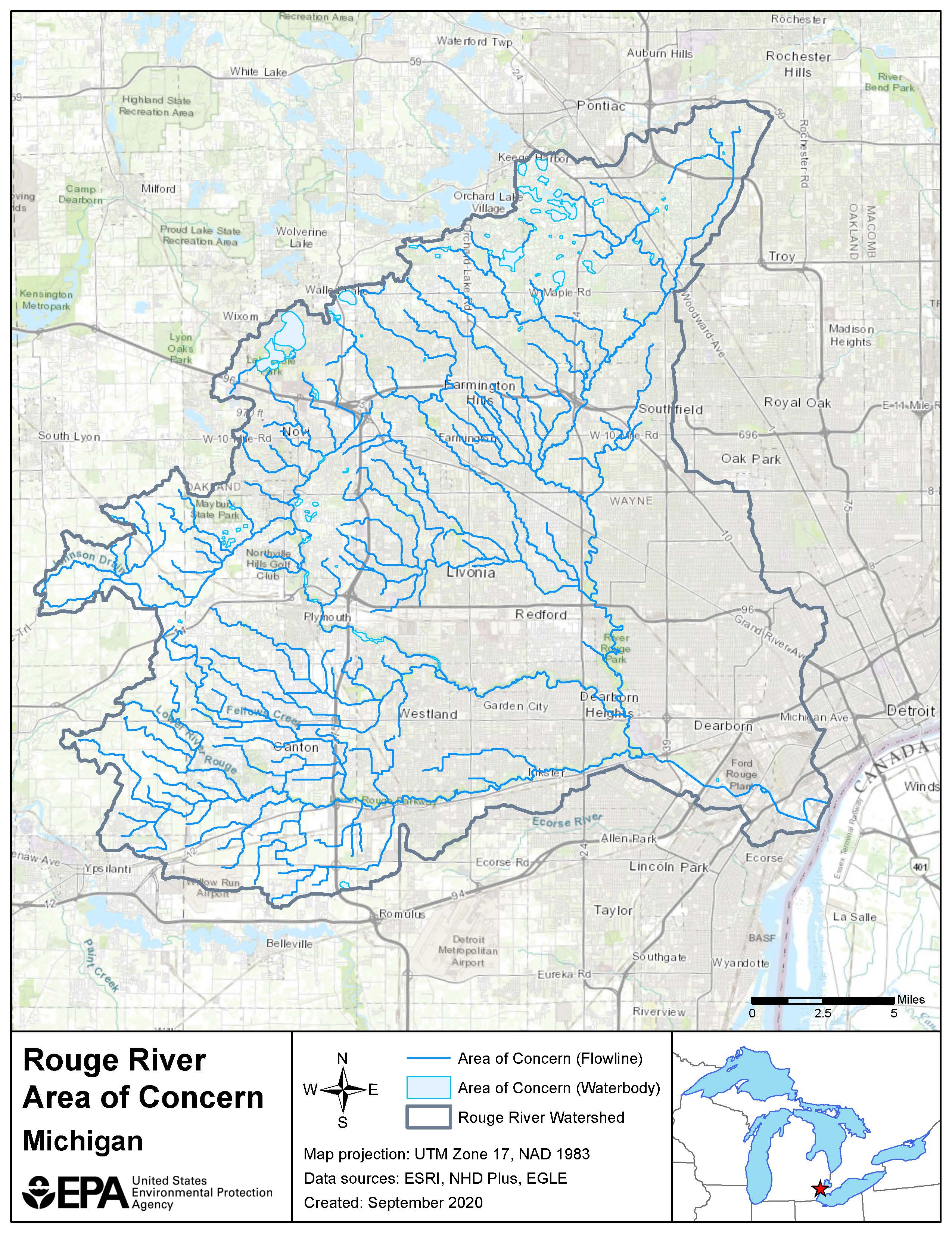
Located in southeastern Michigan, the Rouge River was designated as an Area of Concern under the Great Lakes Water Quality Agreement of 1987. The boundaries should include the main branch of the Rouge River, Upper Rouge River, Middle Rouge River, and Lower Rouge River. Upland areas in the watershed are the source area and the AOC should be delineated as just the waterbodies within the watershed.
The Rouge River watershed drains 466 square miles into the Detroit River and encompasses 48 communities. The Rouge River watershed contains the oldest and most heavily populated and industrialized area in southeast Michigan. This has led to sediment and water contamination from industrial development and discharge, combined and sanitary sewer overflows, and nonpoint source pollution.
Degradation of the Rouge River is representative of that found in many urbanized and industrialized areas within the Great Lakes Basin.
- Over 50% of the land use is residential, commercial, or industrial, with increasing development pressures in the headwaters.
- Over 50 miles of publicly owned parklands in the northern and western portions of the watershed are adjacent to watercourses.
- Land uses include rural, suburban, urbanized and industrial.
Nine of the fourteen Beneficial Use Impairments (BUIs) have been determined impaired for the Rouge River AOC. Sediment and water contamination affect fish and wildlife habitat and populations as well as recreational opportunities. Contaminants within the watershed include heavy metals, polychlorinated biphenyls (PCBs), polycyclic aromatic hydrocarbons (PAHs), mercury, oil and grease. Remedial Action Plan priorities developed for the Rouge River AOC include elimination of combined sewer overflows, nonpoint source pollution control, industrial discharge pretreatment and contaminated sediment cleanup.
Beneficial Use Impairments
An interim success of remediation and restoration work is removing BUIs. BUIs are designations given by the International Joint Commission representing different types of significant environmental degradation. As cleanup work is completed, and monitoring demonstrates sufficient environmental health improvements, BUIs can be removed. No BUIs have been removed from the Rouge River AOC. Once all BUIs are removed, the process of delisting the AOC can begin.
- Restrictions on Fish and Wildlife Consumption
- Eutrophication or Undesirable Algae
- Degradation of Fish and Wildlife Populations
- Beach Closings
- Fish Tumors or Other Deformities
- Degradation of Aesthetics
- Degradation of Benthos
- Restriction on Dredging Activities
- Loss of Fish and Wildlife Habitat
- General information about BUIs: Beneficial Use Impairments for the Great Lakes AOCs
Remediation and Restoration Work
Through multiple partnerships, remediation, and restoration efforts have continued to be implemented within the Rouge River AOC. Following a Degradation of Fish and Wildlife Populations and Degradation of Benthos BUI pre-assessment that was completed in 2014, a list of the most impaired reaches or segments within the AOC were identified. From this list, 25 habitat projects Exit were decided upon. The habitat projects were designed to advance progress and lead to BUI removals. The habitat projects range from river reconnectivity, wetland habitat restoration, streambank naturalization, fish passage, to invasive species management. Implementation of the projects will be a key step forward in the restoration of the Rouge River.
- Documents on Restoring Rouge River AOC
- Remediation and Restoration Projects for Rouge River AOC
-
For more information on the Rouge River AOC habitat projects, please see the Rouge River AOC Fish and Wildlife Plan Addendum.
Highlighted Habitat Restoration and Sediment Remediation Work
- The Henry Ford Estate Dam Fishway Restoration
- The Rouge Oxbow Restoration Project
- Dredging the Lower Rouge River Old Channel
The Henry Ford Estate Dam Fishway Restoration
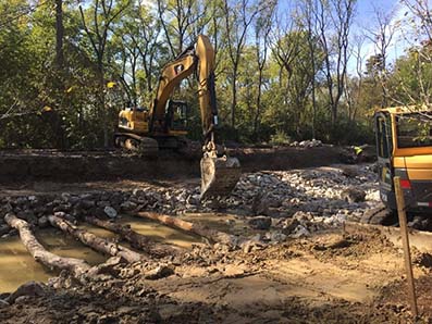 Construction of the naturalized channel that will connect to the Rouge River.The Henry Ford Estate (HFE) Dam Fish Passage and Habitat Restoration Implementation project was identified as a high priority project by the Rouge River Advisory Council in 2011. A naturalized channel will be constructed that will flow into the Rouge River, bypassing the HFE dam. Construction of the channel was begun in summer 2018 and is continuing. Completion of the project will advance efforts towards the removal of the following BUIs:
- Degradation of Fish and Wildlife Populations
- Loss of Fish and Wildlife Habitat
 The naturalized channel will allow for fish passage, bypassing the Henry Ford Estate Dam.The Henry Ford Estate Dam is the first barrier to fish when migrating upstream of the Detroit River. The fishway channel will open fish passage between the Rouge River watershed and the Great Lakes system. This project will supplement two previously completed GLRI fish barrier removal projects, the Wayne Road Dam on the Rouge Lower Branch and the Danvers Pond Dam on the Upper Rouge. Once completed, the project will reconnect 50 main river and 108 tributary miles. This will improve and enhance habitat for many species of fish, macroinvertebrates, mussels, and other aquatic life.
The Fishway Project is a collaborative effort among many project partners, including: U.S. EPA, NOAA, National Park Service, Michigan Department of Natural Resources, Michigan Department of Environment, Great Lakes, and Energy, Wayne County, Alliance of Rouge Communities, and the Rouge River Advisory Council.
The Rouge Oxbow Restoration Project
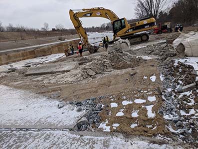 A portion of the concrete channel that lines the Rouge River is removed in order to reconnect the Rouge Oxbow.The Rouge Oxbow Restoration Project began in 2002 through collaboration with multiple partners. The project entered its third phase in 2018. The Rouge River was channelized in the 1970s to mitigate flooding. The constructed concrete channel resulted in the Rouge Oxbow area being disconnected from the Rouge River and precluded fish passage to and from the Detroit River. Over 16 years of efforts to reconnect the system have included channel construction, recreation of 13 acres of wetland and upland habitat, and construction and reconnection of the southeast portion of the oxbow with the Rouge River.
 The final phase of the project reconnects the Rouge Oxbow with the Rouge River, shown here.During the third phase of the project, the Rouge Oxbow will be completely reconnected with the Rouge River. Once the project is complete it will provide many benefits, such as habitat for benthic macroinvertebrates, a resting area for migrating fish, nursery habitat, and restored wetland areas. The reconnection of the Rouge Oxbow will create valuable habitat for bass, bowfin, and channel catfish. The project also incorporates native seed plantings that will benefit pollinators, stabilize the streambank and enhance habitat for wildlife. The Rouge Oxbow Restoration Project is considered to have a significant impact on the removal of the following BUIs:
- Degradation of Fish and Wildlife Populations
- Degradation of Benthos
- Loss of Fish and Wildlife Habitat
The Rouge River Oxbow Restoration Phase 3 Project is a collaborative effort among many project partners, including:
- National Oceanic and Atmospheric Administration
- U.S. Army Corps of Engineers
- Michigan Department of Natural Resources
- Michigan Department Environment, Great Lakes, and Energy
- Wayne County
- Alliance of Rouge Communities
- The Henry Ford Historic Site
- Rouge River Advisory Council
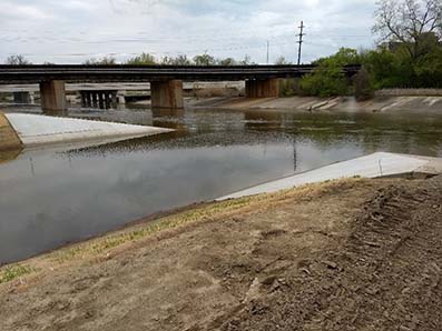
Dredging the Lower Rouge River Old Channel
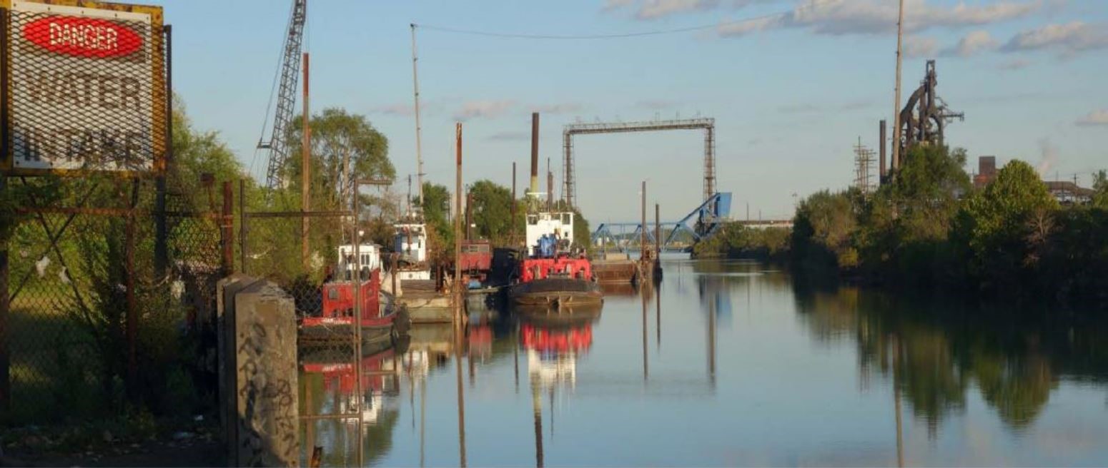 The Lower Rouge River Old Channel.Since 2010, EPA has been working under a Great Lakes Legacy Act partnership with its non-federal sponsor, Honeywell Inc., to investigate, design, and clean up a 0.75-mile stretch of the Lower Rouge River Old Channel (LRROC). The LRROC is a highly industrialized federal navigation channel. The multi-year cleanup effort is to be conducted in two phases. The first phase, conducted in 2018 and 2019, included the installation of a sheet pile along 2,500 feet of the shoreline. The second phase, which is anticipated to start in 2019, will include dredging and capping of contaminated sediment on the river.
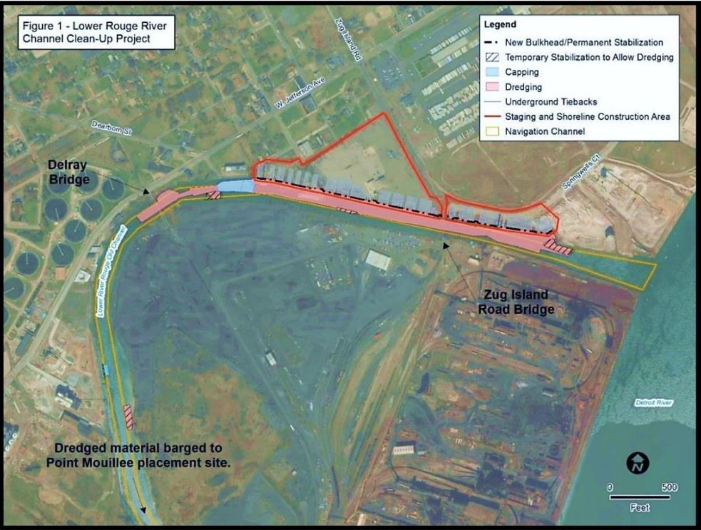 This aerial photo shows the project area and plans for the Lower Rouge River Old Channel sediment cleanup.Phase two involves the dredging of approximately 70,000 cubic yards of sediment from 10 acres. The sediment is polluted with coal tar and other petroleum products and will be transported offsite by barge and disposed of at the US Army Corps of Engineers Point Mouillee Confined Disposal Facility in Monroe, Mich. The project will restore the riverbed by stabilizing the shoreline, removing contaminated sediment, and removing large debris like metal, wood, tires, and nearly a dozen vehicles that have been discarded in the river.
Completion of the project will advance efforts towards the removal of the following BUIs:
- Degradation of Fish and Wildlife Populations
- Loss of Fish and Wildlife Habitat
- Degradation of Benthos
Partners
- National Oceanic and Atmospheric Administration
- The National Park Service
- U.S. Army Corps of Engineers – Detroit District
The following links exit the site Exit