Waukegan Harbor AOC
Contact Us
Nicholas Green
(green.nicholas@epa.gov)
312-353-3718
On this page:
Latest News
Waukegan’s Harbor Cleanup Revitalizes City Scene
Overview
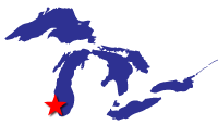
After its construction in 1850, Waukegan Harbor, an artificial harbor constructed by the U.S. Army Corps of Engineers (USACE), became a major regional manufacturing and distribution site. Waukegan Harbor is located approximately 40 miles north of Chicago in Lake County, Ill., on the shore of Lake Michigan. As early as 1885, industries in the Waukegan Harbor area contributed to environmental contamination of both land and water resources during manufacturing processes. Due to the presence of chemical contaminants such as polychlorinated biphenyls (PCBs) discovered in the harbor’s sediment, the harbor was designated as an Area of Concern (AOC) under the 1987 Great Lakes Water Quality Agreement. In addition to PCBs, other chemical contaminants such as heavy metals, phenols, and polycyclic aromatic hydrocarbons (PAHs) were found in and around the heavily industrialized harbor.High levels of chemical contaminants in the sediment can lead to bioaccumulation of harmful chemicals, especially PCBs, in the harbor’s food chain, including contaminated fish that can be hazardous to human health.
The harbor consists of a natural inlet and portions of adjacent wetlands that were filled to form its present shape. In total, Waukegan Harbor consists of approximately 1.2 square kilometers of industrial, commercial, municipal and open or vacant lands.
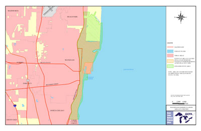
The originally designated Waukegan Harbor AOC is bounded by:
- Government Pier to the south
- Canadian National Railway to the west
- North Ditch to the north
- Lake Michigan shoreline to the east
Of the additional known areas of contamination and National Priority List sites that could impact the original AOC and Lake Michigan’s coastal water. The Extended Study Area is bound by:
- Dead River in Illinois Beach State Park to the north
- Bluff line parallel to Sheridan Road to the west
- South boundary of the former U.S. Steel Property at 22nd St. in North Chicago to the south
- Nearshore waters of Lake Michigan to the east
Beneficial Use Impairments
BUIs are designations created by the International Joint Commission (IJC), representing different types of significant environmental degradation. As restoration and cleanup projects make progress, monitoring at the site can show recovery in environmental health related to the identified BUIs. As cleanup and restoration work is completed, and monitoring demonstrates BUI removal criteria have been met, BUIs can be removed. Out of 14 possible BUIs, six have been designated for the Waukegan Harbor AOC. Below is a comprehensive list of all BUIs identified at the Waukegan Harbor AOC. As of 2020, five of the AOC’s six BUIs have been removed. When the final BUI, “Restrictions on fish and wildlife consumption,” is removed, the process of delisting the AOC can begin. The final BUI is anticipated to be removed in 2022.
- Restrictions on Fish and Wildlife Consumption
- Degradation of Phytoplankton and Zooplankton Populations - Removed 2020
- Degradation of Benthos - Removed 2018
- Beach Closings – Removed 2011
- Loss of Fish and Wildlife Habitat – Removed 2013
- Restriction on Dredging Activities– Removed 2014
More information:
- BUI status and background information for this AOC: Waukegan Harbor Stage I & II RAP and Waukegan Harbor Stage III RAP
- A delisting guideline created for Waukegan Harbor AOC that identifies criteria that must be met to delist the AOC and comparing these criteria to those of other AOCs: Delisting Targets (PDF)
- Information on the results of plankton, benthos and fish sampling conducted 2012: Benthos and Plankton Report (PDF) and Fish Report (PDF)
Remediation and Restoration Work
EPA, federal, state, and local partners implemented sediment remediation and habitat restoration projects at this AOC, to restore the area and ultimately remove Waukegan Harbor’s designation as an AOC. EPA and partners carried out three management actions at this AOC:
- An extensive AOC-wide sediment removal and remediation effort led by EPA and conducted under the title of “Superfund PCB-contaminated Sediment Remediation Project”
- A Great Lakes Restoration Initiative (GLRI)-funded sediment removal and placement project conducted by U.S. Army Corps of Engineers to remove sediment from Waukegan’s Outer Harbor
- A GLRI-funded habitat monitoring and restoration effort conducted by the Waukegan Harbor CAG under a grant entitled “Waukegan Harbor Area of Concern Restoration”
In 2014, EPA completed the Superfund PCB-contaminated Sediment Remediation Project, which targeted the Restrictions on Fish and Wildlife Consumption BUI. Through Superfund, EPA removed contaminated sediment at the Outboard Marine Corporation site, on the northern side of the AOC. This site is the former location of an outboard-boat-motor manufacturing plant and a former railroad tie, coal gasification and coke plant facility. Contaminants of concern included PCBs and trichloroethene (TCE). EPA dredged PCB-contaminated sediment from the source area in 1992 during the initial phases of the clean-up effort. EPA implemented a second phase of the sediment remediation work in order to fully clean up the harbor. Between 2012 and2013, EPA hydraulically dredged, an efficient form of dredging that has minimal impact to the area, the harbor’s sediment with residual PCB contamination andconsolidated it in an on-site disposal facility. In 2014, EPA capped the remaining contaminated sediments. Superfund work is ongoing at the Outboard Marine Corporation site. Through Superfund, EPA also removed contaminated soil and sediment and cleaned contaminated groundwater at adjacent sites in the AOC’s Extended Study Area.
- See EPA Sites in the City of Waukegan for more information on Superfund cleanup work conducted in the Waukegan Harbor AOC and its Extended Study Area.
Also, in 2014, USACE completed the GLRI-funded project to remove sediments, test for exceeding regulatory levels of chemical contamination, and place sediments from Waukegan’s Outer Harbor onto the Waukegan Coke Plant site. This management action targeted the Restrictions on Dredging BUI. USACE placed approximately 82,000 cubic yards of removed sediments as a clean cover on the Coke Plant site following testing. This effort helped remove the Restrictions on Dredging Activities Dredging BUI and signaled the completion of all sediment-related management actions, paving the way for further environmental recovery and restoration.
From 2010 to2016, the Waukegan Harbor CAG administered a habitat monitoring, management, and restoration grant to complete management actions to help remove the Loss of Fish and Wildlife Habitat BUI. The CAG removed invasive species from coastal dune habitat on AOC and Extended Study Area lands and collected baseline monitoring data for coastal dune flora and fauna within the AOC. The goal of this management action was to address habitat degradation and implement complimentary habitat projects in the AOC and Extended Study Area to protect and enhance fish habitat, create pools and riffles for aquatic life within the harbor, control terrestrial invasive species, and protect and restore native plant species. These habitat restoration efforts helped support commercial and industrial facilities along the lakeshore, create better recreational opportunities at public beaches, parks, and marinas, and provide access for boating and fishing.
For more information on restoration work in the Waukegan Harbor AOC:
- Documents on Restoring Waukegan Harbor AOC
- Remediation and Restoration Projects for the Waukegan Harbor AOC
Remediation Project Highlight: USACE Strategic Navigation Dredging
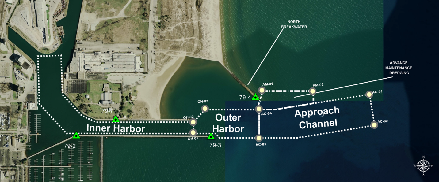 Aerial map showing the Outer Harbor area where contaminated sediment was removed. Credit: USACE.In 2013, USACE dredged approximately 100,000 cubic yards of PCB-contaminated sediment from the entrance channel area of the federal navigation channel. This project included dredging the federal navigation channel and inner harbor areas to a depth of 18 feet and built on progress made by Superfund in removing contaminated sediment from the AOC. This project also made maintenance dredging possible in this area andlowered transportation costs for commercial vessels in the harbor.
Restoration Project Highlight: Critical Habitat Restoration
This project specifically focused on restoring and protecting coastal habitat areas in unique ravine systems between the City of Waukegan Public Beach-North and Illinois Beach State Park. Ravines are v-shaped valleys that provide natural drainage into Lake Michigan. They are a unique coastal habitat and are critical for coastal species to thrive, including migratory and wetland birds, native coastal plant species, and several native Lake Michigan fish species.
The Critical Habitat Restoration Project expanded a green buffer zone around sensitive habitats and wildlife to preserve vital coastal habitat and improve Lake Michigan water quality for nearshore species. This project also implemented actions to prevent erosion and sedimentation in the riparian nearshore area, the interface between land and a river or stream. The project also helped preserve coastal ravines in the upland reaches of the Dead River watershed. Additionally, it increased groundwater infiltration and stabilized for about 160 acres of riparian inflows and ravines that filter water into Lake Michigan. Finally, this project gathered baseline biological data for the Waukegan Harbor Extended Study Area.
Partners
U.S. Army Corps of Engineers - Chicago District
The following links exit the site Exit