Lake Huron
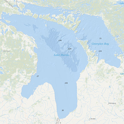 Lake Huron is the Great Lake that forms Michigan's mitten shape right next to Canada. It has the longest shoreline of the Great Lakes. It is the third largest of the lakes by volume with 3,540 km (850 cubic miles) of water. Its average depth is 59 meters (195 feet) and its maximum depth is 229 meters (750 feet); The Saginaw River basin is intensively farmed and contains the Flint and Saginaw-Bay City metropolitan areas. Saginaw Bay, like Green Bay, contains a very productive fishery.
On this page:
About Lake Huron
- the second largest by surface area
- the third largest by volume
- Mackinac Island is a popular toursit attraction
- vacation homes on the shallow, sandy beaches of Huron and along the rocky shores of Georgian Bay
- Saginaw River basin is intensively farmed
- Flint and Saginaw-Bay City metropolitan areas
- Saginaw Bay contains a very productive fishery
NOAA Image Measurement of Depth of Water in Lake Huron Image
What EPA is Doing
- Lakewide Action and Management Plans for the Great Lakes
- Lake Huron Great Lakes Areas of Concern (AOCs)
- Great Lakes Restoration Initiative Grants
-
Michigan Technological University $648,799 for two invasive species control projects ($648,799 and $470,407).
-