Hazardous Waste Cleanup: Northern Indiana Public Service Company (NIPSCO) Bailly Generating Station - Chesterton, Indiana
- Latest News
- Cleanup Status
- Site Description
- Contaminants at this Facility
- Institutional/Engineer Controls
- Land Reuse
- Site Responsibility
Latest News
- The public comment period for the NIPSCO Bailly Generating Facility Statement of Basis closed on Oct. 19, 2020. EPA received a significant number of substantive comments. We are in the process of carefully reviewing all comments. Due to the complexity of some comments and the unique circumstances involving impacts at a National Park, EPA anticipates the Final Decision/Response to Comments will be released in the first quarter of 2021. Thorough consideration of the comments will require additional time and consultation with stakeholders.
- NIPSCO Bailly Generating Facility Proposed Statement of Basis Question and Answer Session (PDF)(23 pp, 404 K, About PDF) - Aug. 3, 2020
- Hazardous Waste Cleanup: Northern Indiana Public Service Company (NIPSCO) Public Comment form - deadline Oct. 19, 2020
- Factsheet: Statement of Basis Released Public Comment Period Open - July 2020
- Statement of Basis for Area C (PDF) (155 pp, 31.43 MB, About PDF) - June 22, 2020
- Frequently Asked Questions - updated Aug. 31, 2020
- Virtual Public Meeting video best viewed in full screen mode.
Congress amended the Resource Conservation and Recovery Act (RCRA) in November 1984, expanding the Act's cleanup provisions and prompting EPA and its state partners to develop the RCRA Corrective Action Program. The program oversees the investigation and cleanup of nearly 4,000 hazardous waste sites across the country, including many with risks comparable to Superfund sites.
The NIPSCO Bailly Generating Station (Bailly) is a 350-acre former coal-fired power plant located along the southern shoreline of Lake Michigan.
Cleanup Status
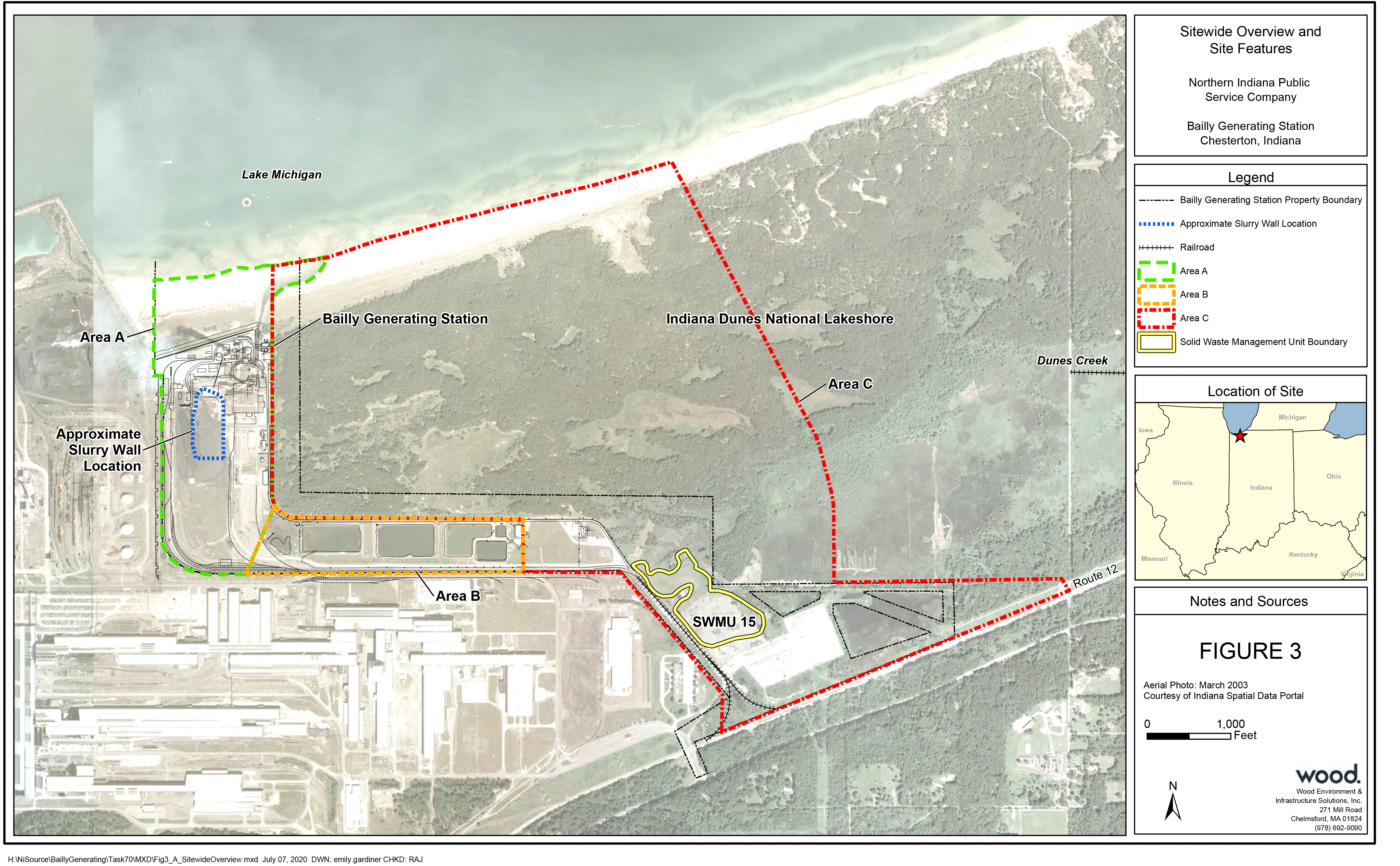 Map of Area C (PDF) of the NIPSCO Bailly Generating Facility near the Indiana Dunes National Park.Portions of the site (Areas A and B) were remediated under a July 9, 2012 Final Decision document (see “Reports” under Additional Site Information). Those areas included the power generation buildings and surrounding infrastructure. However, since that Final Decision, the Bailly Facility has closed and no longer uses that infrastructure to burn coal or generate electricity.
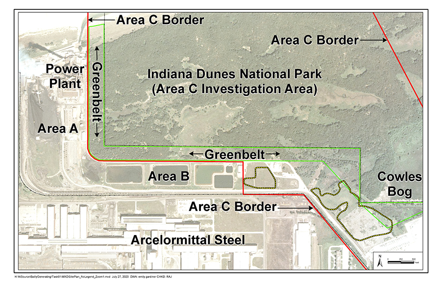
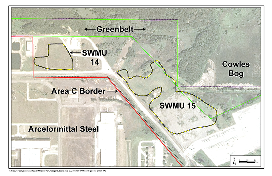
EPA is currently proposing the remedy for the remaining portion of the site, referred to as Area C. This area includes former coal ash disposal areas (Solid Waste Management Units, or “SWMU 14” and “SWMU 15”) and the adjacent, off-site portions of the Indiana Dunes National Park (IDNP). The figure to the right shows all three areas of the Facility. Area C is outlined in red; Area A is outlined in green and Area B is outlined in orange.
EPA has issued its Statement of Basis document(PDF)155 pp, 31.43MB, About PDF), which provides details on the investigation and proposed remedy based upon years of data collection and evaluation.
The proposal is being shared with the public prior to EPA selecting a remedy, as comments will be collected and considered in the final decision. After the public comment period has ended, EPA will provide written responses to comments in our Final Decision/Response to Comments document.
Remedies proposed by EPA for Corrective Action sites must demonstrate an ability to protect human health and the environment. Therefore, EPA is proposing the following remedies for Area C:
SWMU 14: No Action Needed
SWMU 14 was investigated and the data evaluated. Under the Corrective Action program, it was determined that this area does not pose a risk to people or the environment. See Frequently Asked Questions.
SWMU 15: Partial Excavation and Off-Site Disposal of Coal Combustion Residuals (“CCR”) with In-Situ Solidification (“ISS”) of CCR Below the Water Table
SWMU 15 is an area where NIPSCO historically disposed of coal combustion residuals, or ash, on its property. CCR contaminants commonly include metals such as the aluminum, arsenic, boron, molybedenum, and selenium that were found in this area. Under this proposed remedy, NIPSCO will excavate the CCR located above the water table (approximately 100,000 cubic yards) and dispose of it safely off-site. The remaining CCR, located below the water table, (approximately 85,000 cubic yards) will be stabilized and contained through the process of solidification (called “in-situ solidification/stabilization” or “ISS”). ISS is a common method of containment involving mixing additives with waste to physically and chemically reduce the mobility and toxicity of contaminants. ISS encapsulates the waste and forms a solid material while chemical reactions between the additives and waste further bind the contamination into a solid mass.
Greenbelt and Eastern Wetland: Excavation and Off-Site Disposal
A small amount of CCR was discovered in the off-site Greenbelt area and adjacent IDNP property. The presence of CCR within IDNP is inconsistent with the standards for a National Park, therefore excavation and off-site disposal is the only proposed option (referred to as the “presumptive remedy”). Based on the investigation, NIPSCO will excavate the CCR and intermingled soil for safe off-site disposal with a target volume of 705 cubic yards. The excavated material will be replaced with clean dune sand from an approved source and NIPSCO will collaborate with IDNP to restore the area with native plantings.
IDNP Groundwater: Source Control and Monitored Natural Attenuation (“MNA”)
Groundwater contaminated by the CCR (primarily, boron) in SWMU 15 has migrated off-site to the IDNP property. The proposed remedy will require regular monitoring of the groundwater with an expectation that remedial objectives will be met within a timeframe of 15 years. This approach is predicated on eliminating the leaching CCR in SWMU 15 that is the source of contamination. A contingency plan will be evaluated in the event source control and natural attenuation do not achieve remedial endpoints. The contingency plan, which could include additional or different monitoring to verify conditions, will be done in consultation with IDNP.
Previously Barren IDNP Soil Area: Monitored Natural Attenuation
The source of the altered soil pH in this area was the previously unlined wastewater and coal ash settling ponds, which were lined in 1980. Observed trends in the area indicate conditions are returning to normal and native plant communities are being re-established. This remedial option requires ongoing monitoring with a contingency plan and is proposed, in consultation with IDNP, as the least disruptive option to the National Park. This area will continue to be monitored to ensure historic contamination from the settling ponds is resolved.
Facility-Wide: Land Use Institutional Control
To limit exposure to remaining contaminants, EPA will require NIPSCO to establish and record an environmental restrictive covenant, approved by IDEM and EPA, to restrict the land use of the NIPSCO property to industrial or commercial use, now and in the future. The restrictive covenant will also prohibit the use of groundwater as a drinking water source. This component of the proposed remedy will only apply to the NIPSCO property and is consistent with NIPSCO’s anticipated future land use.
Facility-Wide: Financial Assurance
NIPSCO must demonstrate the financial ability to complete the proposed remedy and long-term monitoring by securing an appropriate funding method.
Facility-Wide: Long Term Stewardship/Five Year Remedy Review
EPA will require NIPSCO to establish a long-term stewardship plan, including monitoring and reporting, for the duration of time that contamination remains above unrestricted-use levels; frequency of data collection and reporting will be defined within that plan. Institutional and engineered controls will be certified on a regular schedule in accordance with an Institutional Control Implementation and Assurance Plan (ICIAP). Five-year reviews, a component of long-term stewardship, will be the method to update the conceptual site model (CSM) as needed.

Site Description
Construction of the coal-fired power plant began in 1959 and it became operational in 1962. Between 1962 and 2018 the facility supplied electricity to the northern half of Indiana. In spring 2018 the facility retired its coal-fired operations.
In 2005, EPA identified a total of 24 areas at the facility that required investigation for possible contamination. A series of sampling events and environmental studies have been conducted since to better understand the nature and extent of contamination. It was determined that coal combustion residuals (CCR), or coal ash, was the main source of contamination. Area A included an area that was used for the temporary placement of coal ash on the ground. That area had contributed to contamination of the groundwater and was subsequently cleaned up under EPA’s 2012 Final Decision. Area C includes a 17-acre area where coal ash had been disposed of between 1965 and 1979. EPA’s forthcoming proposed remedy for Area C includes for that disposal area and the downgradient areas of impact within the Indiana Dunes National Park.
Contaminants at this Facility
Coal Combustion Residuals (“CCR”), or coal ash, is the primary source of contamination at this Facility. The byproduct of burning coal, CCR typically leaves certain types of metals in the ash which can then contaminate soil or groundwater. At Bailly, contaminants consistently detected above screening levels during the investigation included aluminum, arsenic, boron, cadmium, molybdenum, and selenium. Boron has been identified as a risk-driver for the off-site groundwater which impacts the Indiana Dunes National Park (IDNP).
The purpose of a Corrective Action Remedial Facility Investigation (“RFI”) is to determine whether hazardous waste or hazardous constituents were released into the environment at a Facility, and if so, to evaluate the significance of the releases in terms of risk to human health and the environment. During the investigation, environmental media such as soil, groundwater, surface water, sediments, and biota are sampled and analyzed for contamination.
Under EPA oversight, NIPSCO conducted an extensive multi-media investigation in Area C. Soil, sediment, groundwater, surface water, and plant samples were collected to determine the nature and extent of the contamination surrounding IDNP. Over the course of several years and these iterative studies, sufficient information was gathered to determine the impacts of contamination from the Facility on the National Park and how best to address them.
Over the course of the RFI, the following studies were performed to determine what the chemicals of concern were, where they were located, and what risks they posed:
Soil Investigations
- Test pit investigations to delineate the extent of known and suspected CCR in SWMU 14 and 15;
- Soil borings and collection of over 450 samples to characterize soil and identify areas of exceedances of screening criteria and/or background concentrations;
Groundwater & Hydrogeologic Investigations
- Installation of over 50 groundwater monitoring wells on- and off-site;
- Quarterly groundwater, surface water, and sediment sampling to identify exceedances of screening criteria and/or background concentrations;
- Analysis of over 400 sediment samples, over 400 surface water samples, and over 600 groundwater samples;
- Installation and quarterly measurement of staff gauges in the IDNP to identify water flow in low-lying wetland areas;
- Testing and quarterly monitoring well gauging to identify horizontal hydraulic gradients;
- Sampling of the Lake Michigan groundwater/surface water interface (GSI) within IDNP along the shore of the lake;
Ecological (Plant and Animal) Investigations
- Investigation characterizing the amount of vegetative stress in contaminated portions of IDNP;
- Investigation assessing whether a relationship exists between the absence of IDNP vegetation in barren soil areas and presence of Facility-related constituents in soil;
- Assessment of whether a relationship exists between observation of vegetative stress and the presence of Facility-related constituents in soil and plant tissue;
- Amphibian surveys to observe and evaluate the ecological receptors in IDNP wetlands downgradient from the Facility;
- Amphibian surveys to further assess whether Facility-related constituents were impacting IDNP amphibian populations;
- Studied amphibian toxicity to determine whether components of sediment in the IDNP exhibits toxicity to embryonic and/or larval amphibians;
- Testing rhizome and soil to evaluate the potential for plant bioconcentration of metals and subsequent release back to soils; and
- Studying plant toxicity to assess whether Facility-related constituents were impacting plants in the IDNP.
The investigation concluded that contamination leaving the Facility in groundwater from SWMU 15 and entering the IDNP exceeds applicable ecological standards. Groundwater contamination is found in the surface waters of IDNP as a result of the groundwater and surface water being connected. Stressed vegetation has been observed and studied within the National Park. There is a complicated hydrogeologic cycle between the groundwater, surface water and sediment as it pertains to the bioavailability of certain metals. The most chronically exposed receptors to this cycling of contamination between groundwater, surface water, and sediment are plants, as studies demonstrated Facility contamination (primarily boron) within the plant tissue.
Institutional and Engineering Controls at this Facility
Updates forthcoming.
Land Reuse Information at this Facility
NIPSCO has indicated that the type of future reuse or redevelopment at the Bailly facility is currently undecided. This Statement of Basis presumes that future land use at Bailly will be limited to uses consistent with the commercial/industrial cleanup levels. If a non-commercial/industrial use is proposed in the future, then additional risk associated with the specific alternative use must be evaluated. Should the analysis show more cleanup is necessary, then to be protective, additional work would be needed to support the alternative use. At this time, given the extent of the area’s industrial development and the existence of a buffer zone between the industrial area and the National Park, EPA believes that the industrial/commercial use designation is appropriate and consistent with EPA guidance. It is also consistent with the Porter County Zoning Ordinance, which currently has the facility zoned as “High Impact Use” and the buffer area zoned as “Greenway Use”.
Site Responsiblity at this Facility
The RCRA Corrective Action program designates the lead agency as the entity that oversees the investigation and cleanup work. The program was designed to reduce the number of tax-payer Superfund sites. Therefore, the company (NIPSCO) is responsible for the cost and implementation of work. EPA oversees and must approve of all work conducted under the program.