Ecoregions used in the National Aquatic Resource Surveys
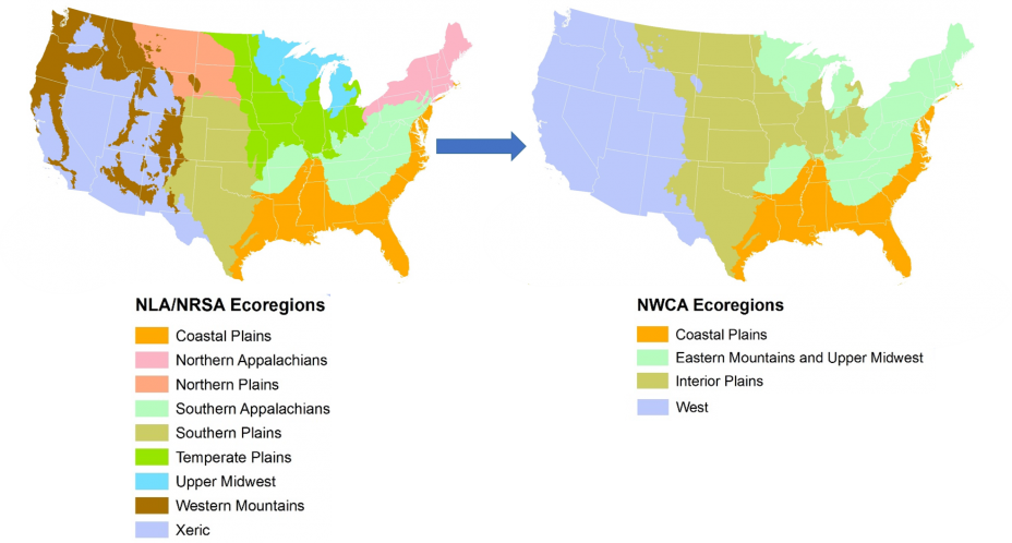
Ecoregions are areas that contain similar environmental characteristics such as climate, vegetation, soil type, and geology. The nine ecoregions used in the National Lakes Assessments (NLA) and the National Rivers and Streams Assessments (NRSA) are aggregations (see Herlihy et al. 2008) of the Level III ecoregions (Omernik 1987, Omernik and Griffith 2014) delineated by EPA for the continental U.S. The National Wetland Condition Assessment (NWCA) further combined the nine aggregated ecoregions into four NWCA ecoregions.
Ecoregional Map of the Conterminous United States
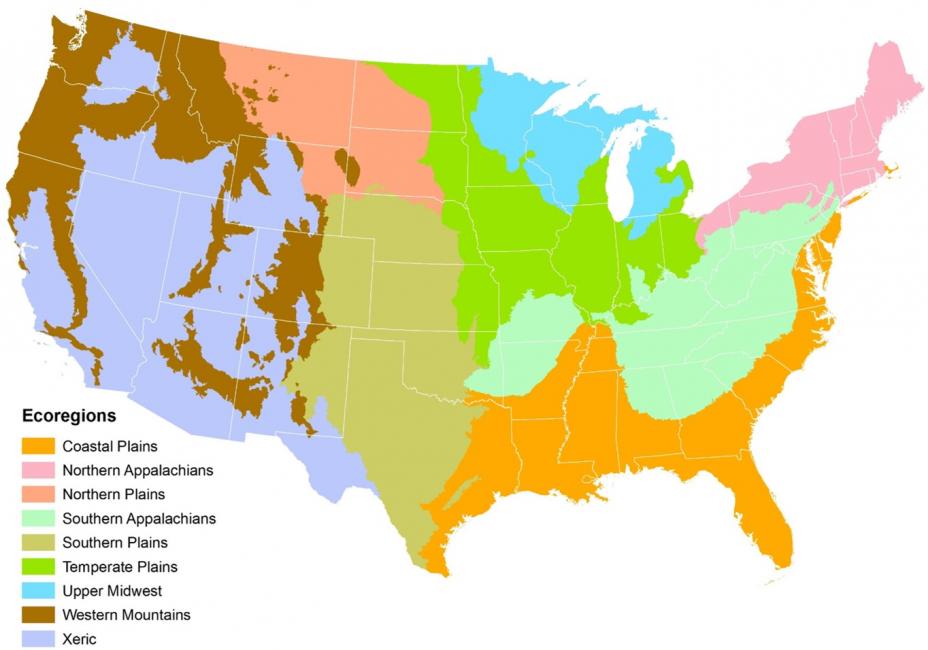 Read about each of the nine ecoregions: Coastal Plains, Northern Appalachians, Northern Plains, Southern Appalachians, Southern Plains, Temperate Plains, Upper Midwest, Western Mountains, Xeric
Coastal Plains
The Coastal Plains (CPL) ecoregion covers the 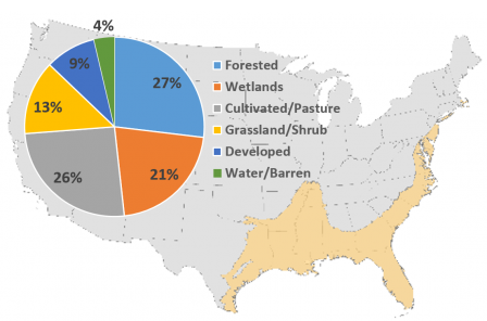 Mississippi Delta and Gulf Coast, all of Florida, eastern Texas, and the Atlantic seaboard from Florida to New Jersey. The topography of this ecoregion is mostly flat plains and contains numerous wetlands and the Everglades. Major lakes in this ecoregion include Toledo Bend (TX), Sam Rayburn Reservoir (TX/LA), Lake Okeechobee (FL), and Lake Marion (SC). In general, rivers in the Coastal Plains meander broadly across flat plains created by river deposition and form complex wetland topographies, with natural levees, back swamps, and oxbow lakes. An exception is the Mississippi River, which carries large sediment loads from dry lands in the central and western portion of its drainage area.
The total area of the Coastal Plains is about 395,000 square miles (13.2% of the conterminous United States). Based on satellite images in the 2011 National Land Cover Dataset, the distribution of land cover in this ecoregion is 27% forested, 26% cultivated/pasture, 21% wetlands, 13% grassland/shrubs, and 9% developed; the remaining area is dominated by open water. The climate is temperate wet to subtropical, with average annual temperatures ranging from 50°F to 80°F and annual precipitation ranging from 30 to 79 inches.
Northern Appalachians
The Northern Appalachians (NAP) 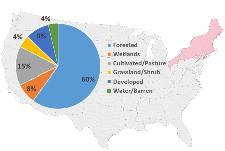 ecoregion covers all of the New England states, most of New York, the northern half of Pennsylvania, and northeast Ohio. It encompasses New York’s Adirondack and Catskill Mountains, and Pennsylvania’s mid-northern tier, including the Allegheny National Forest. This ecoregion is generally hilly, with some intermixed plains and mountain ranges. Major waterbodies include New York’s Finger Lakes and Lake Champlain. Major river systems include the Susquehanna, St. Lawrence, Allegheny, Penobscot, Connecticut, and the Hudson.
The Northern Appalachians ecoregion covers some 139,424 square miles of land (4.6% of the conterminous United States), with about 4,722 square miles of land under federal ownership. Based on satellite images in the National Land Cover Dataset (2011), the distribution of land cover is 60% forested, 15% cultivated/pasture, 9% developed, and 8% wetlands; the remaining area is made up of grassland/shrubs and open water. The climate is cold to temperate, with mean annual temperatures ranging from 39°F to 48°F. Annual precipitation totals range from 35 to 60 inches.
Northern Plains
The Northern Plains (NPL) 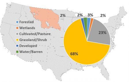 ecoregion includes western North and South Dakota, Montana east of the Rocky Mountains, northeast Wyoming, and a small section of northern Nebraska. This ecoregion’s terrain is irregular plains interspersed with tablelands and low hills. The Northern Plains is the heart of the Missouri River system and is almost exclusively within the Missouri River’s watershed. Several major reservoirs are along the Missouri River mainstem, including Lake Oahe and Lake Sacajawea. Devils Lake in North Dakota is another major waterbody in the ecoregion.
The Northern Plains ecoregion covers approximately 205,084 square miles (6.8% of the conterminous United States). Based on satellite images in the 2011 National Land Cover Dataset, the land in this ecoregion is 68% grassland/shrub and 23% cultivated/pasture; the remaining area is either forested or developed, or is covered by wetlands or open water. The climate in this ecoregion is dry and characterized by short, hot summers, and long, cold winters. Temperatures average 36°F to 46°F, and annual precipitation totals range from 10 to 25 inches. High winds are an important climatic factor in this ecoregion, and the Northern Plains are also subject to periodic intense droughts and frosts.
Southern Appalachians
The Southern Appalachians 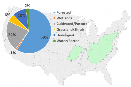 (SAP) ecoregion stretches from northeastern Alabama to central Pennsylvania. This ecoregion includes the interior highlands of the Ozark Plateau, and the Ouachita Mountains in Arkansas, Missouri, and Oklahoma. The topography of this ecoregion is mostly hills and low mountains, with some wide valleys and irregular plains. The configuration of the Southern Appalachian valleys has proven ideal for the construction of manmade lakes, and some of the nation’s largest hydro-power developments can be found in the Tennessee Valley. Major river systems include the Alleghany, Susquehanna, James, and the Potomac.
The Southern Appalachians ecoregion covers about 321,900 square miles (10.7% of the conterminous United States). Based on satellite images in the 2011 National Land Cover Dataset, land cover in this ecoregion is 59% forested, 22% cultivated/pasture, 10% developed, and 6% grassland/shrubs; the remaining area includes open water and wetlands. The climate is considered temperate wet, with mean annual temperature ranging from 55°F to 65°F. Annual precipitation totals range from 40 to 80 inches.
Southern Plains
The Southern Plains (SPL) 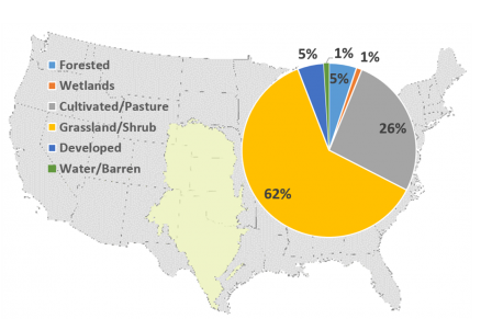 ecoregion includes central and northern Texas, most of western Kansas and Oklahoma, and portions of Nebraska, Colorado, and New Mexico. The terrain is a mix of smooth and irregular plains interspersed with tablelands and low hills. The Arkansas, Platte, White, Red, and Rio Grande rivers flow through this ecoregion. Most of the Ogallala Aquifer, one of the world’s largest water table aquifers, lies beneath the Southern Plains ecoregion.
The Southern Plains ecoregion covers approximately 405,000 square miles (13.5% of the conterminous United States). Based on satellite images in the 2011 National Land Cover Dataset, the land in this ecoregion is 62% grassland/shrub, 26% cultivated/pasture, 5% forested, 5% developed, and the remainder is made up of wetlands and open water. The climate in this ecoregion is dry temperate, with mean annual temperatures ranging from 45° to 79°F. Annual precipitation is between 10 and 30 inches.
Temperate Plains
The Temperate Plains (TPL) 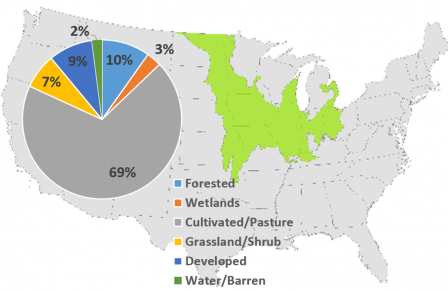 ecoregion includes the open farmlands of Iowa; eastern North and South Dakota; western Minnesota; portions of Missouri, Kansas, and Nebraska; and the flat farmlands of western Ohio, central Indiana, Illinois, and southeastern Wisconsin. The terrain of this ecoregion consists of smooth plains and many small lakes and wetlands. Over 60% of lakes in this ecoregion are smaller than 100 hectares in size. Many of the rivers in this ecoregion drain into the Upper Mississippi River, Ohio River, and Great Lakes watersheds.
The Temperate Plains ecoregion covers some 342,200 square miles (11.4% of the conterminous United States). Based on satellite images in the 2011 National Land Cover Dataset, the distribution of land cover in this ecoregion is 69% cultivated/pasture, 10% forested, 9% developed, 7% grassland/shrub, and the remainder area is made up of wetlands and open water. The climate is temperate, with cold winters, and hot and humid summers. Mean temperatures range from 36°F to 55°F and annual precipitation ranges from 16 to 43 inches.
Upper Midwest
The Upper Midwest (UMW) 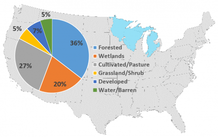 ecoregion covers most of the northern half and southeastern part of Minnesota, two-thirds of Wisconsin, and almost all of Michigan. The glaciated terrain of this ecoregion typically consists of plains with some hills. Lakes, rivers, and wetlands predominate in most areas. Major lakes of the region include Lake of the Woods and Red Lake in Minnesota. The river systems in this ecoregion empty into portions of the Great Lakes regional watershed and the upper Mississippi River watershed. Major river systems include the upper Mississippi River in Minnesota and Wisconsin; the Wisconsin, Chippewa, and St. Croix rivers in Wisconsin; and the Menominee and Escanaba rivers in Michigan. Other important water bodies include four of the Great Lakes (Superior, Michigan, Huron, and Erie).
The total area of the Upper Midwest ecoregion is about 160,374 square miles (5.3% of the conterminous United States). Based on satellite images in the 2011 National Land Cover Dataset, the distribution of land cover in this ecoregion is 36% forested, 27% cultivated/pasture, 20% wetlands, and the remainder is made up of developed land, grassland/shrubs, and open water. The climate is characterized by cold winters and relatively short summers, with mean annual temperatures ranging from 34°F to 54°F. Annual precipitation ranges from 20 to 47 inches.
Western Mountains
The Western Mountains (WMT) ecoregion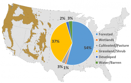 covers parts of many states in the Western U.S. (Washington, Oregon, Idaho, California, Montana, Wyoming, Colorado, Utah, Arizona, New Mexico, Texas, and South Dakota). The ecoregion includes the Cascade, Sierra Nevada, and Pacific Coast mountain ranges in the coastal states; the Gila Mountains in the southwestern states; and the Bitterroot and Rocky Mountains in the northern and central mountain states. The terrain of the Western Mountains ecoregion is characterized by extensive mountains and plateaus separated by wide valleys and lowlands. Lakes and ponds in this ecoregion range from large mainstem impoundments to high-mountain caldera and kettle lakes, such as Crater Lake (OR) and Lake Yellowstone (WY). The headwaters and upper reaches of the Columbia, Sacramento, Missouri, and Colorado River systems all occur in the Western Mountains. This ecoregion’s coastal mountains are transected by many fjords and its glacial valleys are bordered by coastal plains that include important estuaries along the margins of the ocean.
The Western Mountains ecoregion covers about 397,832 square miles (13.2% of the conterminous United States). Based on satellite images in the 2011 National Land Cover Dataset, the land in this ecoregion is 54% forested, 37% grassland/shrub and the remainder is made up of cultivated/pasture, developed, barren land, and wetlands. The climate is sub-arid to arid and mild in southern lower valleys; it is humid and cold at higher elevations. The wettest climates of North America occur in the marine coastal rainforests of this ecoregion. Mean annual temperatures range from 32°F to 55°F, and annual precipitation ranges from 16 to 240 inches.
Xeric
The Xeric (XER) ecoregion 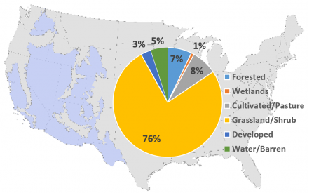 covers portions of eleven western states (Washington, Oregon, Idaho, California, Utah, Arizona, New Mexico, Texas, Wyoming, Colorado, and Montana) and all of Nevada. The terrain of the Xeric ecoregion is composed of a mix of physiographic features, including plains with hills and low mountains, high-relief tablelands, piedmont, high mountains, and intermountain basins and valleys. The ecoregion includes the flat to rolling topography of the Columbia/Snake River Plateau; the Great Basin; Death Valley; and the canyons, cliffs, buttes, and mesas of the Colorado Plateau. Major lakes in this ecoregion include large Colorado impoundments such as Lake Mead, Lake Powell, and Lake Havasu. Its relatively limited surface water supply contributes to the Upper and Lower Colorado, Great Basin, California, Rio Grande, and Pacific Northwest regional watersheds. Large rivers that flow all year are supplied by snowmelt and have peak flows in early summer. Small rivers are mostly ephemeral.
The Xeric ecoregion covers about 636,583 square miles (21.2% of the conterminous United States). Based on satellite images in the 2011 National Land Cover Dataset, the land in this ecoregion is 76% shrub/scrub and grassland, 8% cultivated/pasture, 7% forested, and the remainder is made up of barren land, developed land, and wetlands. The climate in this ecoregion varies widely from warm and dry to temperate, with mean annual temperatures ranging from 32°F to 75°F and annual precipitation ranging from 2 to 40 inches.
National Wetland Condition Assessment Grouped Ecoregions
To allow assessment of condition for distinct wetland types across ecoregions with an acceptable degree of statistical certainty (i.e., a sufficient number of sampled sites by wetland type), NWCA further combined the nine aggregated ecoregions into four NWCA ecoregions:
- Coastal Plains
- Eastern Mountains and Upper Midwest
- Interior Plains
- West
References
Herlihy, A.T., Paulson, S.G., Van Sickle, J., Stoddard, J.L., Hawkins, C.P., and L.L. Yuan. 2008. Striving for consistency in a national assessment: the challenges of applying a reference-condition approach at a continental scaleExit. Journal of the North American Benthological Society 27(4):860-877.
Omernik, J.M. 1987. Ecoregions of the conterminous United States. Annals of the Association of American Geographers 77:118-125.
Omernik, J.M., and G.E. Griffith. 2014. Ecoregions of the conterminous United States: evolution of a hierarchical spatial framework. Environmental Management 54(6):1249-1266.
Download a shapefile of the nine aggregated ecoregions(23 MB)
