News Releases from Region 01
EPA Works to Address Ongoing Water Quality Needs in the Charles River on 25th Anniversary of Initiative
BOSTON, MA – The US Environmental Protection Agency (EPA) is observing the 25th anniversary of targeted efforts to improve water quality in the Charles River. This year, as in earlier years, EPA is announcing a Report Card for the river in coordination with the Charles River Watershed Association (CRWA). The two organizations have developed a new grading system to document water quality for the entire length of the Charles River, rather than solely the Lower Basin (Watertown to Boston), and other enhancements to the grading methodology to provide additional information to the public.
"EPA is very proud of our 25-year history of collaboration and partnership to improve water quality in the Charles River. Thanks to a long-term commitment by many organizations and dedicated individuals, we have seen real improvement in the Charles River and its value as a recreational hub in the Boston metro area, and in upper reaches of the river system. However, more work needs to be done, especially to reduce phosphorus pollution. On the 25th Anniversary of EPA's first concentrated efforts to improve water quality in the Charles, EPA is continuing our focus on improving water quality in the river," said EPA New England Regional Administrator Dennis Deziel.
Charles River Report Card
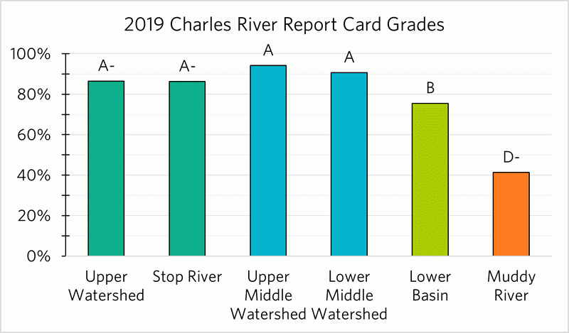
Since 1995, EPA has issued a grade based on water quality in the Lower Basin of the Charles River – the span stretching from Watertown to Boston – using E coli data from water samples collected monthly by CRWA volunteers. Starting last year, CRWA has implemented a methodology to expand the assessment to include all 80 miles of the river and two tributaries, based on data from 39 sampling sites rather than eight. The current assessment evaluates water samples collected during the 2019 calendar year, and looks at six sections of the river: the Upper Watershed (Hopkinton to Medfield), the Upper Middle Watershed (Sherborn to Dedham), the Lower Middle Watershed (Newton to Waltham), the Lower Basin (Watertown to Boston), the Stop River, and the Muddy River.
The new grading systems continues to measure the percentage of time bacterial water quality meets swimming and boating standards. Boating standards continue to be met nearly all the time throughout the watershed, while swimming standards are typically met in dry weather but continue to be impacted by precipitation events. In addition to E. Coli bacteria, the river is also being graded on cyanobacteria (toxic blue-green algae) blooms and combined sewer overflows (CSOs), which are both public health hazards, especially for boaters and anyone who comes into contact with the water. Cyanobacterial blooms, which have occurred with greater frequency in the lower basin, are caused in part by excess phosphorous washing into the watershed from pavement and other impervious surfaces. CSO discharges occur when heavy precipitation events overwhelm portions of the sewer system, and discharges of sewage mixed with stormwater are necessary to prevent sewage backups into streets and residences.
"While E. Coli bacteria levels are an important public health indicator, they do not tell the whole story," said Emily Norton, Executive Director of CRWA. "People have a right to know about the additional risks caused by toxic algae blooms and raw sewage discharges. And knowledge is power! The more people know what is happening to the river, the more motivated they'll be to support the investments necessary to clean it up. The data make it very clear: we have this beautiful resource sitting in our backyard. If we want to protect it, we have to step it up."
The new grading system demonstrates the wide variability in water quality in different stretches of the river. Based on 2019 data, grades range from an "A" in the middle reaches of the Charles River (Sherborn to Waltham) to a "D-" in the Muddy River, a tributary in Boston. The Upper Watershed, while experiencing reduced water levels and encroaching development in the area, received an "A-". The Lower Basin of the Charles River, the popular reach between Watertown and Boston, received a "B."
 Another change to the grading system is that a three-year rolling average will now be used to calculate the grade for each segment. The current year's grade is averaged with the prior two years to produce the "rolling" three-year average. Such a system allows for a more complete and accurate assessment of recent water quality and is designed to better address precipitation variability from year to year, while allowing for real data trends to be more easily discerned.
EPA has also taken two additional actions to address elevated levels of nutrients that are harming water quality throughout the Charles River Watershed. First, EPA has finalized a municipal stormwater permit which will improve stormwater management in Massachusetts communities. Stormwater is the leading source of phosphorus pollution in the Charles, which causes annual blooms of toxic algae in the river. Second, EPA has launched a process to gather stakeholder input about a potential path to address stormwater runoff from commercial, industrial, institutional, and residential properties in the Charles River watershed that are not currently regulated. EPA is evaluating that input and expects to make a decision in 2021.
"The Commonwealth is proud to partner with the U.S. EPA, CRWA and local communities to help achieve the water quality improvements that we've seen in recent years along the Charles River," said Kathy Baskin, Assistant Commissioner for Water Resources in the Massachusetts Department of Environmental Protection (MassDEP). "As we mark 25 years of working to improve the Charles, MassDEP will continue to provide hands-on assistance with stormwater and water quality issues to help to fully restore this historic waterway."
Final MS4 Permit
On December 9, EPA finalized targeted modifications to the 2016 Small Municipal Separate Storm Sewer System (MS4) general permit for 267 Massachusetts communities. The permits, which will apply to 34 communities in the Charles River Watershed, update stormwater management efforts across the state's urbanized areas that will better protect rivers, streams, ponds, lakes, and wetlands from harmful pollutants in many communities. While updating ecological protection, the permit also maximizes flexibility for individual municipalities to tailor their efforts to individual needs and local conditions.
Charles River Residual Designation Discussions
For several months EPA has engaged in discussions with stakeholders in the Charles River watershed to evaluate whether a new program is needed to control stormwater pollution from certain commercial, industrial, institutional, and residential sources in the watershed at sites that are not currently covered by any existing federal or state stormwater permit. EPA is incorporating the stakeholder input into a detailed evaluation of impervious cover within the watershed to determine the appropriate next steps to continue further improvements in water quality.
More information:
- EPA's Charles River Website https://19january2021snapshot.epa.gov/charlesriver
- Small Municipal Separate Storm Sewer System (MS4) general permit for Massachusetts communities: https://19january2021snapshot.epa.gov/npdes-permits/massachusetts-small-ms4-general-permit
- Charles River Residual Designation Stakeholder Outreach: https://19january2021snapshot.epa.gov/charlesriver/environmental-challenges-charles-river#ResidualDesignationAuthority