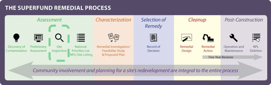
Norwood, Pennsylvania: Current Status
In Fall 2020, EPA conducted additional environmental sampling (known as a Site Investigation) in the lower Norwood area. The goals are to determine 1) if any contaminants from the landfill site pose a risk to the human health and the environment in the Norwood community, and 2) if any longer-term investigation or immediate action is needed to address contaminants.
The 2020 Site Investigation is designed to assess the following:
- Soil contamination and determine site-related contaminants in both public and residential areas
- Conditions of groundwater in the Lower Norwood area
- Potential impacts from the former Norwood Landfill and Old Norwood Dump on Muckinipattis Creek
- Norwood Landfill site eligibility for proposal to the National Priorities List (i.e. the Superfund List), for a longer-term investigation and potential cleanup
Sampling Activities
The sampling was performed in two phases:
- Phase I – Non-Residential Sampling
- Workplan (PDF) You may need a PDF reader to view some of the files on this page. See EPA’s About PDF page to learn more.
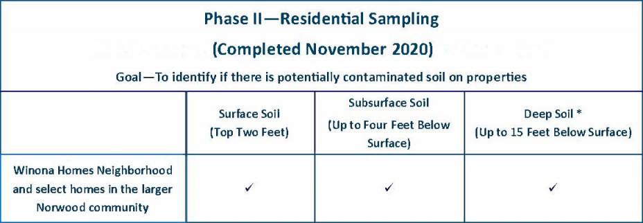
- Phase II – Residential Sampling
- Workplan (PDF) You may need a PDF reader to view some of the files on this page. See EPA’s About PDF page to learn more.
- The primary focus of the residential sampling was the Winona Homes neighborhood.
- EPA sampled a limited number of homes outside of the Winona Homes neighborhood.
Samples will be analyzed for the most commonly encountered chemicals at waste sites, which includes:
- inorganic metals
- mercury
- cyanide
- volatile and semi volatile organic compounds (VOCs)
- pesticides
- polychlorinated bi-phenyls (PCBs)
- furan
- dioxin
The tables below highlight the areas that were sampled in each phase as well as a description of the types of samples that were taken.
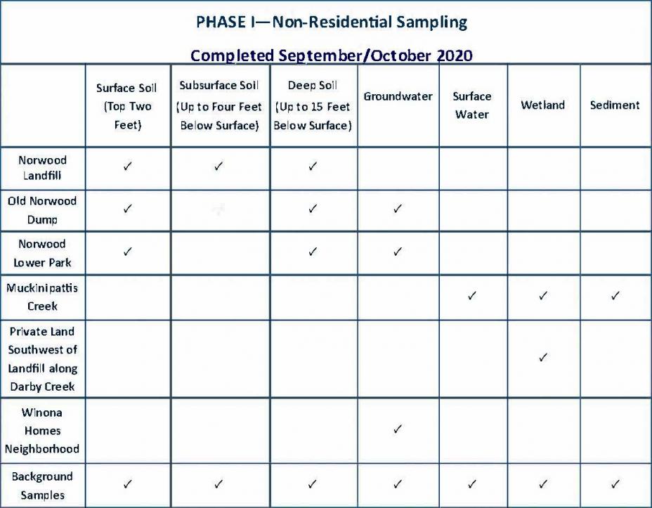
*Background samples are used as references to compare with samples from areas of concern. These samples help determine if a site is contaminated by representing the norm of what is found in the local environment.
Map of Proposed Sampling Locations
More Information about Phase II – Residential Sampling
For site investigations, sampling activities must be based upon the identification of a potential source of contamination. The anecdotal information on landfill activities from long-time residents and historic aerial photos indicate the Winona Homes neighborhood should be the focus of EPA's investigation.
Properties were selected where residents expressed interest in sampling while also ensuring locations are representative of the soil conditions within the neighborhood. Approximately 57 homes within the Winona Homes neighborhood were sampled.
EPA sampled approximately 13 homes outside of the Winona Homes neighborhood to be used as background samples. Background samples are used as references to compare with samples from areas of concern. These samples help determine if a site is contaminated by representing the norm of what is found in the local environment. These additional samples were collected from areas north, south, and west of the Winona Homes neighborhood and will help to provide a comprehensive look at the entire community. The properties were randomly selected based on property owners who expressed interest in sampling at the November 21, 2019 public meeting. Even though homes outside of the Winona Homes neighborhood will be used as background samples, they will be evaluated by the same process as the other residential samples. If any of the sampling data shows an exceedance of a screening level, EPA will consult with the site toxicologist and the Agency for Toxic Substances and Disease Registry (ATSDR) to conduct a human health risk screening assessment to determine any potential threat to human health. If the results are found to pose an immediate threat to public health or the environment, EPA will implement appropriate response actions.
EPA’s Plan Following the Completion of Sampling
Based on the results of the data, EPA may further expand its area of investigation in the future, if necessary. It will take several months for the laboratory to analyze and validate the samples taken in the fall of 2020. Once the data has been received and reviewed, EPA will make its findings available to the public. EPA will not be able to share the identifying locations of residential sampling results due to privacy issues but can provide an overview of the findings in the area.
Information about the site that is collected in the Site Investigation phase helps EPA to evaluate the risks posed by the site using what is called the Hazard Ranking System (HRS). The HRS is a screening tool used by EPA to evaluate the potential threat to human health and the environment posed by an actual or potential release of hazardous substances. EPA will consult with Pennsylvania Department of Environmental Protection (PADEP) and both agencies will evaluate options to address potential risks to human health, which could include proposing the Site for inclusion on the National Priorities List (or Superfund List) for long-term investigation and possible cleanup.
Update on the Public Health Evaluation
Additionally, the Agency for Toxic Substances and Disease Registry (ATSDR) is collaborating with the Pennsylvania Department of Health (PADOH) to conduct a public health evaluation of the environmental data for the Norwood community, which will include some consideration of the available statistics on cancers for the area. All cancers diagnosed in Pennsylvania are required to be reported to the state’s cancer registry. For the PADOH and ATSDR review for the Norwood community, the Agencies will be focusing on the cancer information for people who were residents in the Norwood area at the time of their cancer diagnosis.
The complex nature of cancer makes it challenging to establish a connection between cancers or other illnesses and environmental exposures. PADOH and ATSDR will share what they are able to evaluate on the public health side for the Norwood site in a public report in the spring or summer of 2021.