Managing Ocean Dumping in EPA Region 4
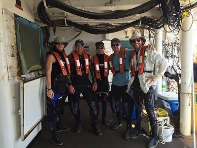 EPA Region 4 staff getting ready to conduct a dive survey at Fernandina Beach, FL Dredged Material Disposal Site.Region 4’s Ocean Dumping Management Program plays an essential role in keeping our oceans safe and clean, while supporting the marine transportation system and the economy. Region 4 serves Alabama, Florida, Georgia, Kentucky, Mississippi, North Carolina, South Carolina and 6 tribes. Region 4 encompasses ocean waters offshore of Alabama, Florida, Georgia, Mississippi, North Carolina and South Carolina.
On this page:
- Announcements
- Ocean Dumping Permits (for materials other than dredged material)
- Ocean Disposal of Fish Wastes
- Ocean Disposal of Dredged Material in Region 4
- Dredged Material Testing for Ocean Disposal in Region 4
- Ocean Disposal Sites in Region 4
- Regional Dredging Teams and Other Partnerships
- Beneficial Use
- Contact Region 4
Announcements
There are no announcements at this time.
Ocean Dumping Permits
Under the Marine Protection, Research and Sanctuaries Act (MPRSA), EPA is the permitting agency for the ocean disposal of all materials except dredged material. The U.S. Army Corps of Engineers (USACE) is the permitting agency for ocean disposal of dredged material. See below for additional information about ocean disposal of dredged material. EPA has issued MPRSA general permits for the ocean dumping of certain materials that may have a minimal adverse environmental impact and are generally disposed of in small quantities. In rare instances, EPA Regional Offices may issue an emergency, research or special ocean dumping permit to an individual or entity.
EPA Region 4 provides localized support and implements the following MPRSA general permits to ensure responsible disposal of wastes and other materials in their ocean waters:
- Burial at Sea of cremated or non-cremated human remains. Reports must be submitted to EPA Region 4.
- Disposal of Vessels at Sea -- Requires consultation with EPA Region 4.
- Ocean Disposal of Marine Mammal Carcasses -- Requires consultation with EPA Region 4.
Please visit our Ocean Dumping Permits Web page for additional information.
Ocean Disposal of Fish Wastes
For information about the disposal of fish wastes in ocean waters, please see our Disposal of Fish Wastes Web page.
Ocean Disposal of Dredged Material in Region 4
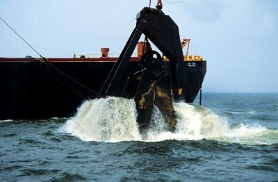 A clamshell dredge bucket in operation.The regulation of dredged material disposal in ocean waters is a shared responsibility of Region 4 and the USACE South Atlantic Division.
Under the MPRSA, USACE is the federal agency that decides whether to issue a permit authorizing the ocean disposal of dredged materials or authorize federal navigation projects involving ocean disposal of dredged materials. USACE relies on EPA’s ocean dumping criteria when evaluating permit requests for (and implementing federal projects involving) the transportation of dredged material for the purpose of dumping it into ocean waters. EPA’s ocean dumping criteria consider, among other things:
- the need for dumping;
- the environmental impact of the dumping, including the effect of dumping on marine ecosystems, shorelines and beaches;
- the effect of the dumping on esthetic, recreational or economic values;
- the adverse effect of dumping on other uses of the ocean including navigation, scientific study, fishing and resource exploitation activities; and
- appropriate locations and methods of disposal or recycling, including land-based alternatives.
All MPRSA permits for dredged material disposal in ocean waters, and federal projects involving dredged material disposal in ocean waters, are subject to EPA review and written concurrence. EPA may concur, concur with conditions, or decline to concur (i.e., non-concur) on the proposed permit. If EPA concurs with conditions, the final permit issued by USACE must include those conditions (for example, ocean disposal site use conditions). If EPA declines to concur on the proposed permit, the permit cannot be issued. The USACE-led review and permitting process is facilitated by early coordination, including review and approval of the sampling and analysis plan, ensuring full characterization of the project sediments proposed to be dredged.
For additional information about MPRSA permits and federal projects involving dredged material, please see Ocean Disposal of Dredged Material Web page.
Dredged Material Testing for Ocean Disposal in Region 4
Evaluation of dredged material for ocean disposal under the MPRSA relies largely on biological tests, using standardized procedures and test organisms, also referred to as bioassays. The ocean testing manual, also known as the “Green Book,” provides national technical guidance for determining the suitability of dredged material for ocean disposal through chemical, physical and biological evaluations. The technical guidance is intended for use by dredging applicants, laboratory scientists, and regulators. Regional guidance is provided in the Regional Implementation Manual.
- Testing Guidance Manual for the Evaluation of Dredged Material Proposed for Ocean Disposal (Green Book)
- Southeast Regional Implementation Manual for Requirements and Procedures for Evaluation of the Ocean Disposal of Dredged Material in Southeastern U.S. Atlantic and Gulf Coast Waters
For more information regarding dredged material testing, including additional guidance documents, please visit our Testing and Evaluation Web page.
Ocean Disposal Sites in Region 4
Region 4 is responsible for designating and managing ocean disposal sites for all types of materials in the Region. Appropriate management of ocean dumping sites is aimed at assuring that disposal activities will not unreasonably degrade or endanger human health and welfare, the marine environment or cause excessive economic impacts. All currently designated ocean sites in Region 4 are for the disposal of dredged material permitted or authorized under the MPRSA.
Each ocean disposal site must have a site management and monitoring plan (SMMP). Region 4, in collaboration with the USACE, is responsible for developing SMMPs for ocean dredged material disposal sites.
Region 4, often in coordination with USACE, monitors ocean dredged material disposal sites. Monitoring surveys may include, but are not limited to:
- sediment analysis for physical properties;
- sediment analysis for chemical contamination;
- benthic infaunal community analysis;
- video imagery from dive surveys, remotely-operated vehicles, or benthic sleds;
- remote-sensing surveys including multibeam surveys and side-scan sonar surveys;
- sediment profile imagery;
- benthic trawls; and
- water quality testing.
Please visit our Ocean Disposal Map and Ocean Disposal Sites Web pages to view a national map of ocean disposal sites and to learn more about site managment and monitoring under the MPRSA.
The map below presents Region 4's ocean disposal sites offshore of Alabama, Florida, Georgia, Mississippi, North Carolina and South Carolina.
- The size of the orange circles represents the square area of the disposal site.
- Click on the disposal sites/vessel disposals for more information on EPA’s ocean disposal sites and vessels disposed at sea.
Descriptions of the ocean disposal sites, site management and monitoring plans, and monitoring results in Region 4 are provided below.
- Alabama Disposal Sites
- Florida Disposal Sites
- Georgia Disposal Sites
- Mississippi Disposal Sites
- North Carolina Disposal Sites
- South Carolina Disposal Sites
Alabama Disposal Sites
Mobile, AL Dredged Material Disposal Site
Location:
30°13.0’'N, 88°08.8’W; 30°09.6’N, 88°04.8’W; 30°08.5’N, 88°05.8’'W; 30°08.5’'N, 88°12.8’W; 30°12.4’N, 88°12.8’W (NAD83)
Size: 23.8 square nautical miles
Depth: Average 42 feet
Use: Dredged material disposal
Management Plan: Mobile SMMP
Monitoring Reports:
Florida Disposal Sites
Canaveral Harbor, FL Dredged Material Dumpsite
Location: 28⁰20.2669’ N, 80⁰31.1696’ W; 28⁰18.8670’ N, 80⁰29.2362’ W; 28⁰17.2337’ N, 80⁰30.8696’ W; 28⁰18.6170’ N, 80⁰32.7363’ W (NAD83)
Size: 4.00 square nautical miles
Depth: 47- 55 feet
Use: Dredged material disposal
Management Plan: Canaveral Harbor SMMP
Monitoring Reports: Canaveral Harbor Monitoring Reports
Fernandina Beach, FL Dredged Material Disposal Site
Location: 30⁰33.0143’ N, 81⁰19.1217’ W; 30⁰33.0143’ N, 81⁰16.8550’ W; 30⁰31.0144’ N, 81⁰19.1217’ W; 30⁰31.0144’ N, 81⁰16.8550’ W (NAD83)
Size: 4.00 square nautical miles
Depth: Average 52.49 feet
Use: Dredged material disposal
Management Plan: Fernandina Beach SMMP
Monitoring Reports: Fernandina Beach Monitoring Reports
Fort Pierce Harbor, FL Ocean Dredged Material Disposal Site
Location: 30°21.514′ N, 81°18.555′ W; 30°21.514′ N, 81°17.422′ W; 30°20.515′ N, 81°17.422′ W; 30°20.515′ N, 81°17.012′ W; 30°17.829′ N, 81°17.012′ W; 30°17.829′ N, 81°18.555′ W (NAD83)
Size: 1.00 square nautical miles
Depth: 40- 54 feet
Use: Dredged material disposal
Management Plan: Fort Pierce SMMP
Monitoring Reports: Fort Pierce Harbor Monitoring Reports
Jacksonville, FL Dredged Material Disposal Site
Location: 30⁰21.5144’ N, 81⁰18.5549’ W; 30⁰21.5144’ N, 81⁰17.4215’ W; 30⁰20.5145’ N, 81⁰17.4215’ W; 30⁰20.5145’ N, 81⁰18.5549’ W (NAD83)
Size: 4.56 square nautical miles
Depth: 28- 61 feet
Use: Dredged material disposal
Management Plan: Jacksonville SMMP
Monitoring Reports: Jacksonville Monitoring Reports
Miami, FL Ocean Dredged Material Disposal Site
Location: 25⁰45.5226’ N, 80⁰03.8859’ W; 25⁰45.5226’ N, 80⁰02.8192’ W; 25⁰44.5226’ N, 80⁰03.8859’ W; 25⁰44.5226’ N, 80⁰02.8192’ W (NAD83)
Size: 1.00 square nautical miles
Depth: 426.51- 787.40 feet
Use: Dredged material disposal
Management Plan: Miami SMMP
Monitoring Reports: Miami Monitoring Reports
Palm Beach Harbor, FL Ocean Dredged Material Disposal Site
Location: 26°46.87’ N, 79°56.21’ W; 26°46.87’ N, 79°56.96’ W; 26°46.70’ N, 79°56.21’ W; 26°46.70’ N, 79°56.96’ W (NAD83)
Size: 1.00 square nautical miles
Depth: 525- 625 feet
Use: Dredged material disposal
Management Plan: Palm Beach Harbor SMMP
Monitoring Reports: Palm Beach Harbor Monitoring Reports
Pensacola Nearshore, FL Dredged Material Disposal Site
Location: 30⁰17.4120’ N, 87⁰18.4983’ W; 30⁰17.0120’ N, 87⁰19.8317’ W; 30⁰15.6120’ N, 87⁰17.7983’ W; 30⁰15.2621’ N, 87⁰19.2983’ W (NAD83)
Size: 2.48 square nautical miles
Depth: Average 36.09 feet
Use: Dredged material disposal
Management Plan: Pensacola Nearshore SMMP
Monitoring Reports:
Pensacola, FL Ocean Dredged Material Disposal Site
Location: 30°08.833’ N, 87°19.5’ W; 30°08.833’ N, 87°16.5’ W; 30°07.083’ N, 87°16.5’ W; 30°07.083’ N, 87°19.5’ W (NAD83)
Size: 4.53 square nautical miles
Depth: 65- 80 feet
Use: Dredged material disposal
Management Plan: Pensacola SMMP
Monitoring Reports:
Port Everglades Harbor, FL Ocean Dredged Material Disposal Site
Location: 26°06.928’ N, 80°01.815’ W; 26°06.928’ N, 80°01.272’ W; 26°06.666’ N, 80°01.815’ W; 26°06.666’ N, 80°01.272’ W (NAD83)
Size: 1.00 square nautical miles
Depth: 640- 705 feet
Use: Dredged material disposal
Management Plan: Port Everglades Harbor SMMP
Monitoring Reports: Port Everglades Harbor Monitoring Reports
Tampa, FL Ocean Dredged Material Disposal Site
Location: 27°32.450’ N, 83°06.033’ W; 27°32.450’ N, 83°03.766’ W; 27°30.450’ N, 83°06.033’ W; 27°30.450’ N, 83°03.766’ W (NAD83)
Size: 4.00 square nautical miles
Depth: Average 72.18 feet
Use: Dredged material disposal
Management Plan: Tampa SMMP
Monitoring Reports:
Georgia Disposal Sites
Brunswick Harbor, GA Ocean Dredged Material Disposal Site
Location: 31⁰02.5974’ N, 81⁰17.6555’ W; 31⁰02.5974’ N, 81⁰16.4887’ W; 31⁰0.5141’ N, 81⁰16.4887’ W; 31⁰0.5141’ N, 81⁰17.68888’ W (NAD83)
Size: 2.00 square nautical miles
Depth: Average 29.53 feet
Use: Dredged material disposal
Management Plan: Brunswick Harbor SMMP
Monitoring Reports: Brunswick Harbor Monitoring Reports
Savannah, GA Dredged Material Disposal Site
Location: 31⁰55.8964’ N, 80⁰44.3230’ W; 31⁰57.9296’ N, 80⁰46.7898’ W; 31⁰57.9296’ N, 80⁰44.3230’ W; 31⁰55.8964’ N, 80⁰46.7898’ W (NAD83)
Size: 4.26 square nautical miles
Depth: Average 37.40 feet
Use: Dredged material disposal
Management Plan: Savannah SMMP
Monitoring Reports: Savannah Monitoring Reports
Mississippi Disposal Sites
Gulfport, MS Dredged Material Disposal Site- Eastern Site
Location: 30⁰11.1787’ N, 88⁰58.4018’ W; 30⁰11.2120’ N, 88⁰57.5018’ W; 30⁰07.6120’ N, 88⁰54.4016’ W; 30⁰7.4120’ N, 88⁰54.8017’ W (NAD83)
Size: 2.47 square nautical miles
Depth: Average 29.86 feet
Use: Dredged material disposal
Management Plan: Gulfport SMMP
Monitoring Reports:
Gulfport, MS Dredged Material Disposal Site- Western Site
Location: 30⁰12.0120’ N, 89⁰0.5019’ W; 30⁰12.0120’ N, 88⁰59.5019’ W; 30⁰11.0120’ N, 89⁰0.0019’ W; 30⁰07.0120’ N, 88⁰56.5017’ W; 30⁰06.6120’ N, 88⁰57.0018’ W; 30⁰10.5120’ N, 89⁰0.6019’ W (NAD83)
Size: 5.20 square nautical miles
Depth: Average 26.90 feet
Use: Dredged material disposal
Management Plan: Gulfport SMMP
Monitoring Reports:
Pascagoula, MS Ocean Dredged Material Dumpsite
Location: 30⁰12.1120’ N, 88⁰44.5013’ W; 30⁰11.7120’ N, 88⁰33.4008’ W; 30⁰08.5120’ N, 88⁰37.0009’ W; 30⁰08.3120’ N, 88⁰41.9011’ W (NAD83)
Size: 18.50 square nautical miles
Depth: 38- 52 feet
Use: Dredged material disposal
Management Plan: Pascagoula SMMP
Monitoring Reports: Pascagoula Monitoring Reports
North Carolina Disposal Sites
Morehead City, NC Dredged Material Disposal Site
Location: 34⁰38.5097’ N, 76⁰44.9793’ W; 34⁰38.5097’ N, 76⁰41.6791’ W; 34⁰38.1597’ N, 76⁰40.9791’ W; 34⁰36.0098’ N, 76⁰40.9791’ W; 34⁰36.0098’ N, 76⁰44.9793’ W (NAD83)
Size: 8.00 square nautical miles
Depth: Average 39.37 feet
Use: Dredged material disposal
Management Plan: Morehead City SMMP
Monitoring Reports:
Wilmington, NC Ocean Dredged Material Disposal Site
Location: 33⁰46.0105’ N, 78⁰02.4827’ W; 33⁰46.0105’ N, 78⁰0.9826’ W; 33⁰41.0106’ N, 78⁰0.9826’ W; 33⁰41.0106’ N, 78⁰03.9827’ W (NAD83)
Size: 9.40 square nautical miles
Depth: 35- 52 feet
Use: Dredged material disposal
Management Plan: Wilmington SMMP
Monitoring Reports: Wilmington Monitoring Reports
South Carolina Disposal Sites
Charleston, SC Ocean Dredged Material Disposal Site
Location: 32⁰38.1107’ N, 79⁰41.9380’ W; 32⁰40.7107’ N, 79⁰47.4883’ W; 32⁰39.0774’ N, 79⁰49.3383’ W; 32⁰36.4774’ N, 79⁰43.7881’ W (NAD83)
Size: 11.80 square nautical miles
Depth: Average 36.09 feet
Use: Dredged material disposal
Management Plan: Charleston SMMP
Monitoring Reports: Charleston Monitoring Reports
Georgetown Harbor, SC Ocean Dredged Material Disposal Site
Location: 33⁰11.3100’ N, 79⁰07.3193’ W; 33⁰11.3100’ N, 79⁰05.3692’ W; 33⁰10.6434’ N, 79⁰05.3858’ W; 33⁰10.6434’ N, 79⁰07.3359’ W (NAD83)
Size: 1.00 square nautical miles
Depth: 19.69- 36.09 feet
Use: Dredged material disposal
Management Plan: Georgetown Harbor SMMP
Monitoring Reports: Georgetown Harbor Monitoring Reports
Port Royal, SC Ocean Dredged Material Disposal Site
Location: 32°05.00′ N, 80°36.47′ W; 32°05.00′ N, 80°35.30′ W; 32°04.00′ N, 80°35.30′ W; 32°04.00′ N, 80°36.47′ W (NAD83)
Size: 1.00 square nautical miles
Depth: Average 36.00 feet
Use: Dredged material disposal
Management Plan: Port Royal SMMP
Monitoring Reports:
Regional Dredging Teams and Other Partnerships
Region 4 established the Southeast Dredging Team. Team members cooperate in developing comprehensive regional dredged material management plans that identify short-term and long-term disposal alternatives, consider methods to reduce dredging, and maximize beneficial use of dredged materials.
Beneficial Use
Most dredged material represents a valuable resource and should be considered for beneficial uses. Beneficial use is the placement or use of dredged material for some productive purpose from which economic, social or other benefits may be derived. Compared to disposal of dredged material in confined sites, beneficial use reduces the need for disposal. Examples of beneficial use include wetlands restoration, beach nourishment, shoreline construction, and habitat creation. The Clean Water Act (CWA) Section 404 governs discharge of dredged or fill material into “waters of the United States”, including the placement of dredged material in the territorial sea for a purpose other than disposal.
For information on dredged material permitting under CWA 404, please see our Section 404 of the Clean Water Act Web page.
Additional beneficial use documents are available on our web page for Regulations, Guidance, and Additional Ocean Dumping Information.
Contact Region 4
Gary Collins, 404-562-9395, Collins.garyw@epa.gov
Vessel Disposal At Sea Inquiries
Radamés San Miguel Villanueva, 404-562-9345, SanMiguelVillanueva.Radames@epa.gov