Guidance for Determining the Acceptability of Environmental Fate Studies Conducted with Foreign Soils
Memorandum
May 20, 2011
SUBJECT: Revised Guidance for Determining the Acceptability of Environmental Fate Studies Conducted with Foreign Soils
FROM: /s/ Donald J. Brady, Director
Environmental Fate and Effects Division (7507P)
TO: Environmental Fate and Effects Division (7507P)
Office of Pesticide Programs
The Environmental Fate Technology Team has revised the guidance for determining the acceptability of environmental fate studies conducted with foreign soils. In this revised guidance document, the FAO-UNESCO soil classification system has been replaced with the Reference Soil Groups (RSGs) of the World Resources Base (WRB) soil classification system. The guidance document also includes information on the international and U.S. soil taxonomical classification systems, distribution of soil orders in the United States, and specific criteria to help scientists determine when foreign soils are representative of U.S. soils at intended pesticide use sites.
In the ideal case, the registrant would verify that a foreign test soil is representative of the intended use area(s) within the United States. If the registrant does not verify the foreign test soil, then the reviewer must determine if the tested soil is acceptable based on limited knowledge of the "soil taxonomy" or other soil data available in registrant-submitted studies. When there are sufficient data available, the reviewer should use the revised guidance document to determine if a foreign test soil is representative of U.S. soils.
This revised guidance is effective immediately and replaces the February 10, 2006 guidance document signed by Steven Bradbury, entitled "Guidance for Determining the Acceptability of Environmental Fate Studies Conducted with Foreign Soils."
Guidance for Determining the Acceptability of Environmental Fate Studies Conducted with Foreign Soils
Purpose
The purpose of this guidance document is to provide a uniform procedure for evaluating the acceptability of foreign soils used in environmental fate studies submitted to the Environmental Protection Agency (EPA) for the registration of pesticides in the United States. In the ideal case, the registrant verifies that the test soil is representative of the intended use areas within the United States. In most cases, though, this task is conducted by an EPA reviewer and is based on limited soil taxonomy or other soil data from registrant submitted studies. When sufficient data are available, the reviewer can verify the test soil by using the information in this guidance. It remains the registrant's responsibility, though, to provide the necessary information for verification.
Background
Under the Agency's pesticide data requirements, which are specified in 40 CFR Part 158, selected environmental fate and transport studies (e.g., leaching, adsorption/desorption, soil metabolism) are conducted in representative soils to determine the persistence and mobility of a pesticide in the environment. The fate, transport, and transformation harmonized test guidelines of the Office of Chemical Safety and Pollution Prevention (OCSPP Series 835, formerly Subdivision N) state that test soils used in these studies should be collected from typical, intended pesticide use areas in the United States. Soils from foreign sources may be used in conducting these fate studies if the foreign soil has the same characteristics as a soil in the United States from a similar use area. Furthermore, complete information on the soil class, textural characterization, pH, organic matter content, and soil classification should be provided by the registrant so that the EPA reviewer can determine if the chosen soil is representative of U.S. agricultural soils.
EPA's policy concerning the acceptability of studies conducted on foreign soil includes the following elements:
- Data from studies conducted at field test sites or with test materials that are not characteristic of the United States will not be considered in the Agency's risk assessment.
- To demonstrate comparability, data should be submitted that shows the lack of substantial or relevant differences between the selected material or test site and the U.S. material or test site.
- Once comparability has been established, the Agency will assess the acceptability of the data as described in 40 CFR Part 158.
Although the EPA reviewer needs data on soil classification as well as physical and chemical properties of the soils, the Agency rarely receives information, particularly related to soil classification, when foreign soils are used to conduct fate and transport guideline studies. For example, many environmental fate and transport studies have been performed with German loamy sand (Speyer 2.2 standard soil) and submitted to the Agency for evaluation without a description of the soil classification or its relevance to U.S. soils. Since this soil was used as a benchmark soil in many other agricultural and environmental research projects, the Agency was able to obtain the description of this soil and its classification from the open literature such as Riepert and Felgentreu, 2002 and LUFA Speyer, 2011. The ExitGerman standard soil is a natural soil from Land-und Forstwirtschaftliche Untersuchungsanstalt (Agriculture and Forestry Research Institute) in Speyer, Germany. This soil is classified as a Cambisol, a Soil Unit of the World Resources Base (WRB) Soil Classification System, which is equivalent to an Inceptisol under the U.S. Soil Taxonomy classification system and is representative of some agricultural soils of the United States. Therefore, submitted environmental fate data (such as adsorption/desorption data) using the Speyer 2.2 soil have been considered, in many cases, to be acceptable by the Agency and have been used in the risk assessment process.
Implication of Soil Classification for Foreign Soils
Soil classification systems have been developed to provide scientists and resource managers with generalized information about the nature of a soil found in a particular location. Soil classification also provides information related to the nature of the parent material and the natural distribution of the soil based on soil properties, patterns, and their relationship to the underlying parent materials. In general, environments that share comparable soil forming factors produce similar types of soils globally. This phenomenon makes classification possible. Thus, information related to soil classification of foreign soils is critical in evaluating selected environmental fate studies and their spatial relevance to U.S. soils where the pesticide is proposed to be used. With soil classification and other pertinent information, the Agency will be able to evaluate whether the environmental fate studies conducted on foreign soils are appropriate for use in the U.S. pesticide registration process (based on the intended use). Many classification systems are in use worldwide. Descriptions of the most commonly applied U.S. Soil Taxonomy and WRB soil classification systems are discussed below.
The World Resources Base (WRB) Soil Classification System
The Food and Agriculture Organization (FAO) of the United Nations developed a supra-national classification, which conveys useful generalizations about the formation of soils in relation to the interactive effects of the main soil-forming factors such as parent material, climate, organisms, topography, and time. It was first published in the form of the UNESCO Soils Map of the World in 1974 (FAO-UNESCO 1978, 1987). Since then, new materials have become available. The FAO/UNESCO Soils Map of the World has been partly updated and the FAO legend has been partly replaced by the WRB's Reference Soil Groups (RSGs). The WRB is an international system that enables individual countries to accommodate their national classification system. Like the United States Soil Taxonomy, it makes class separations on the basis of diagnostic soil horizons as well as landforms. Some of the descriptive terminology, in simplified form, has been adopted from the United States Soil Taxonomy. Most soils can be accommodated in the system on the basis of their field descriptions. In 2003, the incorporation of new materials has resulted in a number of basic changes in the updated version, where 30 RSGs were introduced (ExitWorld Soil Resources [Figure 1]). The 2nd edition of the WRB has undergone a major revision. Technosols and Stagnosols have been introduced, leading to 32 RSGs in the most recent document, World Soil Resources Reports - 103 (World Reference Base for Soil Resources, 2006).
The United States Soil Classification System
In 1975, Soil Taxonomy was published by the United States Department of Agriculture's Soil Survey Staff (Soil Survey Staff, 1999). This system for classifying soils has undergone numerous changes since that time, and the eleventh edition was published in 2010 (USDA, 2010) (Keys to Soil Taxonomy). U.S. Soil Taxonomy remains one of the most widely used soil classification systems in the world. The current version of the system has six levels of classification in its hierarchical structure. The major divisions in this classification system, which are based on general characteristics and are refined to specific characteristics, are as follows:
- orders
- suborders
- great groups
- subgroups
- families
- series
A. U.S. map of twelve orders based on Soil Taxonomy is presented in Figure 2. At the highest level, U.S. Soil Taxonomy (USDA, 2011) (Distribution Maps of Dominant Soil Orders) places soils in one of 12 categories known as orders:
- Alfisols (Figure 3)
- Andisols (Figure 4)
- Aridisols (Figure 5)
- Entisols (Figures 6 - 7)
- Gelisols (Figure 8)
- Histosols (Figure 9)
- Inceptisols (Figure 10)
- Mollisols (Figures 11 - 12)
- Oxisols (Figure 13)
- Spodosols (Figure 14)
- Ultisols (Figure 15)
- Vertisols (Figure 16)
At its lowest level of organization, the U.S. system of soil classification recognizes approximately 19,000 different soil series. The distributions and brief descriptions of the major soils within the U.S. are shown in Figures 3-16. Additional information related to Soil Taxonomy and WRB Soil Classification can be obtained online from the University of Idaho (2011) (ExitThe Twelve Soil Orders).
Guidance for the Use of Environmental Fate Data Obtained from Foreign Soils
The information provided in the environmental fate studies and in this guidance, along with any other available and relevant information, can be used to decide if foreign soils:
- Represent U.S soils relevant to the proposed pesticide use areas (resulting in the use of the data if the study is otherwise acceptable).
- Represent U.S. soils that are of limited relevance to proposed pesticide use areas (resulting in the use of the data only for site specific representation if the study is otherwise acceptable).
- Do not represent any U.S. soils that are relevant to proposed pesticide use areas (resulting in the rejection of the data for use in the risk assessment process).
Environmental Fate and Effects Division (EFED) scientists and contractors should use the following criteria to evaluate whether to use a study conducted with foreign soils:
-
EFED scientists and contractors should have soil classification information in registrant submitted fate studies. If this information is not available, adequate data such as soil profile description as well as physical and chemical properties of soils should be provided in the study in order to classify the study soils in accordance with the WRB soil classification (i.e., Reference Soil Groups) or equivalent U.S. Soil Taxonomy classification system. WRB's Reference Soil Groups and equivalent classification under the U.S. Soil Taxonomy classification system are presented in Table 1. Table 2 provides the former FAO soil units with the soil taxonomy equivalent.
-
The U.S. soils represented by the study soils should be considered relevant to and representative of the proposed/intended pesticide use areas in the United States. This guidance (Figures 1-13) contains maps showing the distributions and brief descriptions of the major soils within the United States (USDA, 2011b).
-
For aerobic soil metabolism studies, the study (or an additional study) should include data obtained using U.S. soils and lasting for a sufficient duration to demonstrate similarity in degradation patterns between the foreign and domestic soils regardless of microbial population differences.
If these criteria are not met, the study is not acceptable and cannot be used alone to support risk assessment. In some cases, foreign soils that are representative of soils from specific regions of the United States may have limited relevance to other areas of the United States. In this case, the data may be used to assess risk only in certain site-specific areas for a proposed pesticide use. In such cases, this should be clearly stated in the comments section of the Data Evaluation Records (DERs) and in the risk assessment.
| Reference Soil Groupa | U.S. Soil Taxonomy | Comments |
|---|---|---|
| Acrisolsa | Ultisols with low activity-clays | Highly weathered with low base saturation at some depth. Occurs in southeastern U.S. |
| Albeluvisols | Alfisols that have a glossic horizon (Glossaqualfs, Glosscryalfs, and Glossudalfs) | Minor occurrences in North America |
| Alisols | Ultisols with high-activity clays | Not a dominant soil in North America. Occurs in southeastern U.S. |
| Andosolsa | Andosols | Soils derived from volcanic deposits. Limited to Northwest U.S. and Hawaii. |
| Anthrosols | Inceptisols with plaggen epipedon | Anthrosols are formed or modified through human activities such as addition of organic materials or household wastes, irrigation or cultivation. The group includes soils otherwise known as "Plaggen soils", "Paddy soils", |
| Arenosols | Psamments (Suborder of Entisols. Soils of coarse texture) | Arenosols occur in the widest possible range of climates from very arid to very humid and from cold to hot. Smaller areas are found along coastlines all over the world. |
| Calcisols | Calcids (Aridisols with calcic epipedon) | Secondary accumulation of lime under arid and semi-arid conditions. Occurs in southwestern U.S. |
| Cambisolsa | Inceptisols | Occurs in North America. |
| Chernozems | Borolls, Udools and Ustolls (Suborders of Mollisols that have a frigid, cryic, or pergelic, ustic, and udic soil temperature regime). | Occurs in the U.S. |
| Cryosols | Gelisols | Occurs in the U.S. Most areas of cryosols in North America are in the natural state and are used as wildlife habitat. |
| Durisols | Durids (Aridisols with a duripan). | Soils with hardened secondary silica. The largest extent is in Nevada and Idaho. Most of the soils are used as rangeland or wildlife habitat. |
| Ferralsolsa | Oxisols | None in the continental U.S. |
| Fluvisols | Fluvents and Fluvaquents (Suborders of Entisols) | Recent alluvial soils. |
| Gleysolsa | Aquic suborders of Alfisols, Entisols, Inceptisols and Millisols. | Soils with redoximorphic features. Occurs in the U.S. |
| Gypsisols | Gypsids (Aridisols with gypsic epipedon). | Soils with substantial secondary accumulation of gypsum (CaSO4.2H2O). These soils are found in the driest parts of the arid climate zone. |
| Histosols | Histosols | Occurs in the U.S. |
| Kastanozemsa | Ustolls and Xerolls (Suborders of Mollisols) | Ustolls and xerools occur in the U.S. |
| Leptosols | Lithic Subgroups of Entisols, | Non-agricultural soils with lithic contact. Soils of < 10cm depth over hard rock. Occurs in the U.S. |
| Lixisols | Alfisols with low-activity clays | Occurs in the U.S. |
| Luvisolsa | Alfisols with high-activity clays | Occurs in the U.S. |
| Nitosols | Kandic Great Groups of Alfisols, and Ultisols and different Great Groups of Inceptisols and Oxisols | Occur in north central and east central parts of the U.S. |
| Phaeozemsa | Udolls and Albolls (Suborder of Mollisols) | Prairie soils, lighter than Chernozem. Chernozem-Kastanozem intergrade. Occurs in the U.S. |
| Planosolsa | Aquic suborders (Albaqualfs, Albaquults and Argialbolls) | Soils with a bleached and temporarily water-saturated topsoil. Occurs in the U.S. |
| Plinthosols | Plinthaquox, Plinthaqualfs, Plinthoxeralfs, Plinthustalfs, Plinthaquults, Plinthohumults, Plinthudults, Plinthusuults (Great Groups of Alfisols, Ultisols, and Oxisols) | Soils with plinthite. |
| Podzolsa | Spodosols | Occurs in the U.S. |
| Regosolsa | Ortherents, Psamments (Suborder of Entisols) | Undeveloped soils. Occurs in the U.S. |
| Solonchaksa | Salids (Suborder of Aridisols) | Saline soils. Found in the U.S. |
| Solonetz | Alfisols (Natric Great Group > 15% saturation with exchangeable sodium) | Occurs in the U.S. |
| Stagnosols | No Soil Taxonomy equivalent | Norwegian soil |
| Technosols | No Soil Taxonomy equivalent | Urban soils |
| Umbrisols | Umbrepts and Humitropepts (Great Groups of Inceptisols and Entisols) | Soils with umbric epipedon. Limited to the northwest Pacific seaboard. |
| Vertisolsa | Vertisols | Occurs in the U.S. |
a = In column 1, a indicates Reference Soil Groups (RSGs) are former FAO Soil Units
| FAO Soil Unit | U.S. Soil Taxonomy | Comments |
|---|---|---|
| Lithosols | Entisols Lithic Subgroups, soils of < 10cm depth over hard rock. |
Same as Leptosols of WRB. |
| Rendzinas | Rendolls (Suborder of Mollisols) | Limited to U.S. |
| Xerosols | Aridisols | Aridic moisture regime. Limited to U.S. |
| Yermosols | Aridisols | Aridic moisture regime. Limited to U.S. |
Example of the Use of Limited Soil Taxonomy Data in Submitted Studies
Although the soil order (under U.S. Soil Taxonomy) may not be clearly identified in a submitted study, there may be information available to easily determine the soil order. Each name of an order contains a formative element, as listed in Table 3. For example, in the order name "Entisol," the formative element is ent. In the name "Aridisol," it is id. These formative elements are used as endings for the names of suborders, great groups, and subgroups. The suborder of Entisols that has aquic conditions throughout is called Aquents (L. aqua, water, plus ent from Entisol). The suborder of Entisols that consists of very young sediments is called Fluvents (L. fluvius, river, plus ent from Entisol). Thus, if the taxonomical classification of the soil is given, a reviewer may determine the soil order from that information. For example, a soil with the taxonomical classification "Fluvaquentic Haploxeroll, coarse-loamy, mixed, thermic" can be determined to be of the soil order "Mollisol" based on the -oll in the subgroup name Haploxeroll. A soil with the taxonomical classification "Typic Hapludalf, fine loamy, mixed, mesic" can be determined to be of the soil order "Alfisol" based on the -alf in the subgroup name Hapludalf.
| Name of Order | Formative Element in Name | Derivation of Formative Element |
|---|---|---|
| Alfisols | Alf | Meaningless syllable |
| Andisols | And | Modified from ando |
| Aridisols | Id | L. aridus, dry |
| Entisols | Ent | Meaningless syllable |
| Gelisols | El | L. gelare, to freeze |
| Histosols | Ist | Gr. histos, tissue |
| Inceptisols | Ept | L. inceptum, beginning |
| Mollisols | Oll | L. mollis, soft |
| Oxisols | Ox | F. oxide, oxide |
| Spodosols | Od | Gr. spodos, wood ash |
| Ultisols | Ult | L. ultimus, last |
| Vertisols | Ert | L. verto, turn |
Figures
Direct downloads of maps (e.g., ExitWorld Soil Resources [Figure 1]) available on ExitWRB Map of World Soil Resources site.
 Figure 2
Distribution of major soil orders (USDA, 2011b)
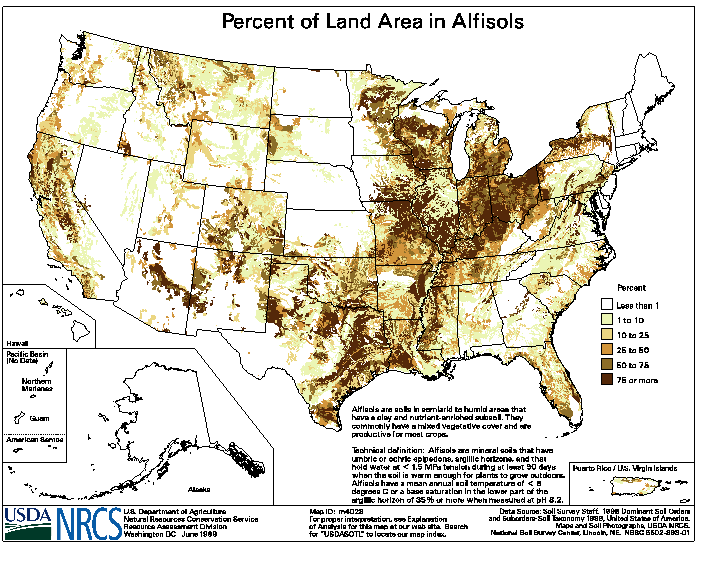 Figure 3
Distribution of Alfisols (USDA, 2011b)
Alfisols
These soils have well-developed horizons (layers), light-colored surface horizons, and a base saturation of 35% or greater. They typically have an ochric epipedon (surface layer), but they may have an umbric epipedon. They may also have a petrocalcic horizon, fragipan, or duripan. With alfisols, the clay in the B horizon is usually illuviated, and the soils contain moderate to high concentrations of base cations. These soils are widely distributed and are usually formed under forest or savanna vegetation.
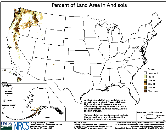 Figure 4
Distribution of Andisols (USDA, 2011b)
Andisols
Andisols are light textured volcanic soils that contain glass and poorly crystalline colloidal materials, including allophane, imogolite, and ferrihydrite (andic properties). They have many unique chemical and physical properties, such as high water-holding capacity. Andisols are the least extensive soil order in the world. In the United States, they occur in the Pacific Northwest region and in Hawaii.
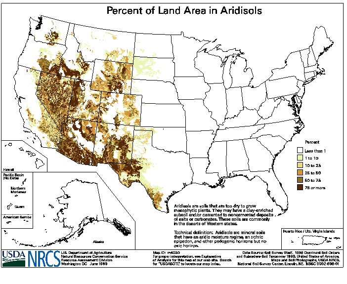 Figure 5
Distribution of Aridisols (USDA, 2011b)
Aridisols
Aridisols, which are commonly found in dry, desert environments, are light-colored soils with shallow and poor soil horizon development. Because of limited rainfall and high temperature, soil water tends to migrate in an upward direction in these soils, and gypsum, salt, and calcium carbonate often accumulate in the surface layer. The hot climate and limited rainfall restrict the growth of mesophytic plants in these dry soils.
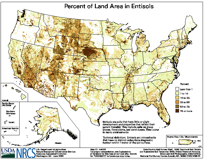 Figure 6
Distribution of Entisols (USDA, 2011b)
Entisols
These soils are sandy and have little or no evidence of development of pedogenic horizons. Many entisols have an ochric epipedon (surface layer), and a few have an anthropic epipedon. Although entisols are shallow and not well-developed, they are commonly found in farmland as well as steep, rocky settings throughout the world and are the most extensive soil order.
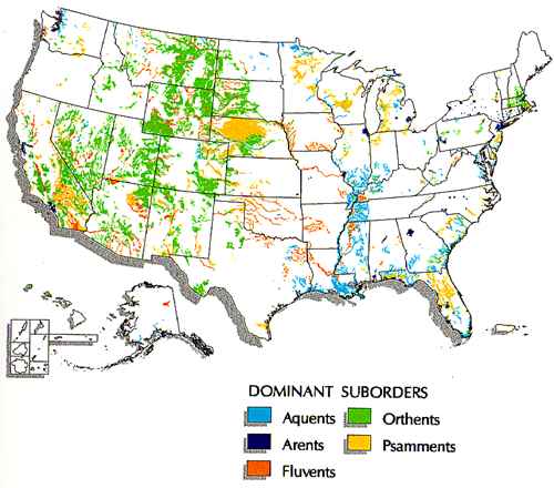 Figure 7
Suborders of Entisols (USDA, 2011b)
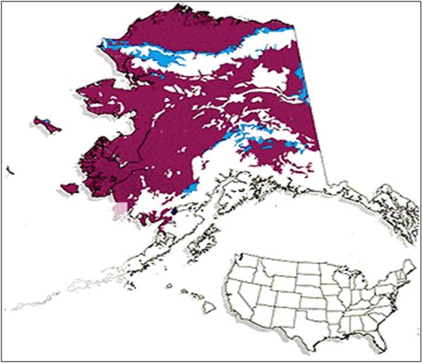 Figure 8
Distribution of Gelisols (USDA, 2011b)
Gelisols
These soils often contain permafrost and/or gelic materials within 100 cm of the soil surface, and permafrost within 200 cm of the surface. Gelic materials are mineral or organic soil materials that have evidence of cryoturbation (frost churning) and/or ice segregation in the active layer (seasonal thaw layer) and/or the upper part of the permafrost. Because of low soil temperatures, decomposition is slow and organic carbon accumulates in these soils. Gelisols are mostly found in high-latitude, polar regions and areas of high mountain elevations. In the United States, they occur predominantly in Alaska.
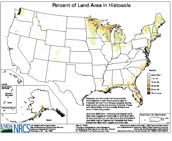 Figure 9
Distribution of Histosols (USDA, 2011b)
Histosols
These soils contain a high percentage of organic matter and are commonly found in bogs, moors, peats, and mucks. Although histosols are not widely distributed, they are ecologically important because they contain a large percentage of organic matter (20-30% by weight). A soil is classified as histosol if it does not contain permafrost and is dominated by organic soil materials.
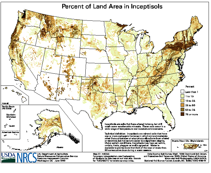 Figure 10
Distribution of Inceptisols (USDA, 2011b)
Inceptisols
Inceptisols usually have lost bases or iron and aluminum but have retained some weatherable minerals. They do not have an illuvial horizon enriched with either silicate clay or with an amorphous mixture of aluminum and organic carbon. Although the inceptisols may have many kinds of diagnostic horizons, argillic, nitric, kandic, spodic, and oxic horizons are excluded.
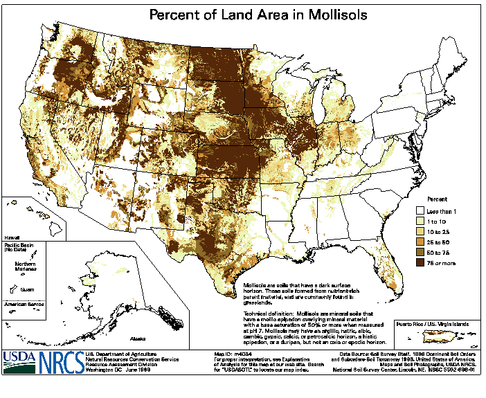 Figure 11
Distribution of Mollisols (USDA, 2011b)
Mollisols
These soils usually have a dark colored surface horizon and are fertile and base rich. Mollisols characteristically form under grass in climate that has moderate to pronounced seasonal moisture deficit. They are found mostly in the middle and western parts of the United States.
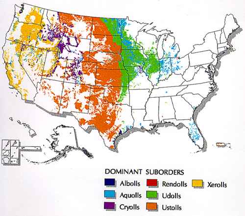 Figure 12
Dominant Suborders of Mollisols (USDA, 2011b)
 Figure 13
Distribution of Oxisols (USDA, 2011b)
Oxisols
These soils are highly weathered and typically occur in tropical and subtropical regions. They commonly occur on gentle slopes with stable landscape. Oxisols are not very fertile soils and contain mixtures of quartz, kaolin, free oxides, and organic matter. Differences in properties associated with depth are so gradual that horizon boundaries are generally arbitrary. In the United States, oxisols are only found in Hawaii and Puerto Rico.
 Figure 14
Distribution of Spodosols (USDA, 2011b)
Spodosols
The A horizon of these soils generally has little silicate clay or humus. Amorphous mixtures of organic matter and aluminum, with or without iron, accumulate in the B horizon of these soils. Undisturbed spodosols normally have an overlaying eluvial horizon, which is generally gray to light gray in color. The particle-size class is mostly sandy, sandy-skeletal, coarse-loamy, loamy-skeletal, or coarse-silty.
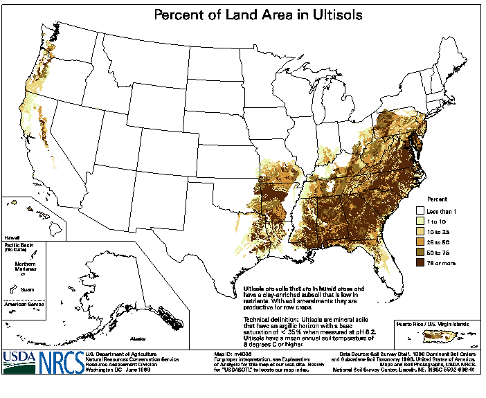 Figure 15
Distribution of Ultisols (USDA, 2011b)
Ultisols
These soils have a horizon that contains appreciable amounts of translocated silicate clay (an argillic or kandic horizon) and few bases (base saturation less than 35 percent). Base saturation in most ultisols decreases with depth. Ultisols are typically weathered, acidic and red in color. The nutrients are often concentrated in the upper few inches. These soils are commonly found in the southeastern United States.
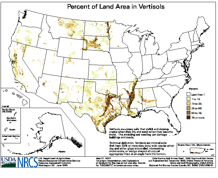 Figure 16
Distribution of Vertisols (USDA, 2011b)
Vertisols
These soils have a high content of expanding clay and may have deep wide cracks at some period of time in the year. Vertisols shrink when drying and swell when wet. These soils, which are found mostly in Texas, are naturally fertile but difficult to cultivate for crop production.
References
Food and Agriculture Organization of the United Nations (FAO). 2011. World Soil Resources. Online at: ExitWorld Soil Resources (accessed May 16, 2011)
FAO-UNESCO, 1978. Report on the Agro-Ecological Zone Project. Food and Agriculture Organization and United Nations Educational, Scientific, and Cultural Organization. World Soil Resources Report 48, Rome, Italy.
FAO-UNESCO, 1987. Soil of the World. Food and Agriculture Organization and United Nations Educational, Scientific and Cultural Organization, Elsevier Science Publishing Co. Inc., New York, NY.
LUFA Speyer. 2011. Exit German Standard Soils. (accessed May 16, 2011).
Riepert, F. and D. Felgentreu. 2002. Relevance of soil storage to biomass development, N-mineralization and microbial activity using the higher plant growth test, ISO 11269-2, for testing of contaminated soils. Appl. Soil Ecology: 20:57-68.
Soil Science Society of America. 2011. ExitGlossary of Soil Science Terms (accessed May 16, 2011)
Soil Survey Staff, 1999. Soil Taxonomy: A Basic System of Soil Classification for Making and Interpreting Soil Surveys. U.S. Natural Resources Conservation Service. USDA Handbook #436. Washington D.C.
U.S. Department of Agriculture. (USDA). 2010. Keys to Soil Taxonomy, 11th ed. USDA, Natural Resources Conservation Service, Washington, DC. (accessed May 16, 2011).
USDA. 2011. Distribution Maps of Dominant Soil Orders (accessed May 16, 2011)
USDA. 2011b Soil Taxonomy Maps (accessed May 16, 2011)
University of Idaho. 2011. ExitThe Twelve Soil Orders: Soil Taxonomy. University of Idaho, College of Agricultural and Life Sciences, Soil & Land Resources Division. (accessed May 16, 2011)
Wild, A. 1988. Russell's Soil Conditions and Plant Growth, 11th ed. Longman and Scientific and Technical, New York, NY. P. 824. April, 1988.
World Reference Base for Soil Resources, 2006. A Framework for International Classification, Correlation and Communication. World Soil Resources Report-103. Rome, Italy.