Simulating Metacommunities of Riverine Fishes (SMRF) Model
EPA developed a model that simulates multiple populations of one or more fish species – a metacommunity –in response to multiple stressors across a river network. The model is called SMRF (Simulating Metacommunities of Riverine Fishes). It is spatially-explicit and age-structured, with three components: habitat suitability; population dynamics, including species interactions; and movement across a spatial network.

SMRF is designed to assist the Agency’s ability to ensure that the nation’s waters are fishable and to assess whether water quality standards are protective of aquatic life. SMRF can also support economic assessment of the benefits of regulations. The model was designed for use by communities, land managers, policy makers, scientists and engineers.
Software, Compatibility, and User's Guides and other Documents
SMRF is a Windows-based desktop program and has been tested up to Windows 10. It is open source public software and is free for use worldwide. In addition to the download available below, you will need to install Microsoft C++ Runtime Library, Microsoft .NET Framework, and an archive extraction software like WinZip to install the model. (Operating systems: Windows)
User Manual and Fact Sheet
Users can implement SMRF through either the included Graphic User Interface (GUI), or by running model components directly from the command line. Advanced users seeking to model large numbers of scenarios for comparison or sensitivity analyses will likely be better served using command line automation. SMRF uses many different files to run the model and generate output. It is important that these files are properly compiled and saved with the correct file extension for the model to run successfully and generate valid output.
More detailed descriptions of the modeling directory file structure, the GUI, and each component file is outlined in subsequent sections of the user manual.
- Simulating Metacommunities of Riverine Fishes (SMRF) User Manual (38 pp, yy K, About PDF) (October 2019)
- BACKGROUND: Learn more about the SMRF version 1.0 model and User Manual
- Science in Action Fact Sheet: (SMRF) A Modeling Approach for Simulating Metacommunities of Riverine Fishes (Jul 2020)
Downloads
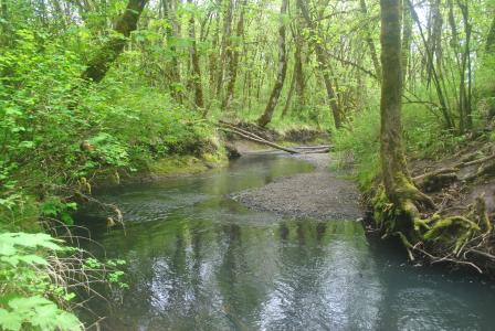
The SMRF distribution package includes a suite of executable (.exe) and input (.xml) files in the form of a zipped working directory. A sample stream network (Calapooia River, OR) and fully parameterized input files are included which allow users to run basic simulations with minimal alteration.
Additional species may be added to the modeled assemblage by performing research to compile relevant and justifiable life-history characteristics and environmental sensitivities for the new species. Default SMRF species have been parameterized from a combination of values derived from peer-reviewed journal articles, government reports, and logistic regression analyses performed on fish sampling data for species/variables where sufficient evidence was not available in the published literature.
Disclaimer: Any mention of trade names, manufacturers, or products does not imply an endorsement by EPA. EPA and its employees do not endorse any commercial products, services, or enterprises.
Capabilities
Modeling can be used to assess the consequences of multiple stressors to multiple populations of one or more fish species across a river network. Modeling represents important process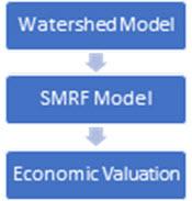 es in order to assess scenarios. The SMRF model takes input to measure water quality and habitat, which may change through time. SMRF’s outputs include relative numbers of different species of fish within watersheds, with the expectation that abundances will capture order-of-magnitude differences among species and general patterns of distribution (presence/absence).
Therefore, SMRF can be incorporated into an integrated modeling system for watershed management and prediction. Watershed models can provide flow, temperature, nutrients, and other habitat varables to SMRF, which can provide fish species abundance, distribution, and diversity to economic models.
Problem
Fish in rivers provide valuable benefits to people, including food, recreation, and cultural value. Fish are also visible indicators of river health.
Riverine fish can be affected by changes in habitat and water quality resulting from land development and human activities in the watershed. Stressors from these activities – altered flow, temperature, sediment, nutrients, and other pollutions – can affect water quality and habitat conditions for fish. Understanding how stressors affect fish is complicated by interactions among fish species, as well as patterns of movement across river networks.
Environmental managers are working to best protect and restore water quality and habitat in watersheds that provide valued fish populations. To best target their activities, managers require tools to help understand how fish populations will respond to management actions.
EPA's Approach
Modeling can be used to assess the consequences of multiple stressors to multiple populations of one or more fish species across a river network. Modeling represents important processes in order to assess scenarios.
So EPA developed a model that simulates multiple populations of one or more fish species, referred to as a metacommunity, to assist the Agency’s ability to ensure that decision makers have the information they need to determine how to keep the nation’s waters fishable and to assess whether water quality standards are protecting aquatic life. SMRF can also support economic assessment of the benefits of regulations. The model was designed for use by communities, land managers, policy makers, scientists and engineers.
Model Structure
The SMRF model is typically set up to run across a network of connected river reaches. Fish populations are simulated within and among river reaches that can vary in suitability. Fish species in the model can be input using PisCES, an EPA tool that estimates fish at unsampled sites. Data collected through EPA’s National Aquatic Resource Surveys can be used to calibrate the model. SMRF simulates survival and reproduction of multiple age classes, where survival is affected by habitat, water quality, competition, and predation.
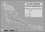
SMRF model input includes measures of water quality and habitat, which may change through time. SMRF’s outputs include relative numbers of different species of fish within watersheds, with the expectation that abundances will capture order-of-magnitude differences among species and general patterns of distribution (presence/absence).
Applications
 SMRF provides useful insights into the net effects on fish communities of stream network habitat conditions (water temperature, channel slope, stream size), spatial configuration (proximity of seasonal habitats), and fish species characteristics (fecundity, survival, competition). Some example applications are to:
- Compare the effects of watershed and water quality management scenarios on fish communities.
- Communicate to landowners how activities on their property are connected to fish in the larger context.
- Support assessment of potential outcomes for biotic integrity based on watershed and water quality improvements, habitat losses, or other changes.
- Identify critical knowledge gaps or refine assumptions where data are currently lacking.
- Evaluate the expected benefits to fish of spatially-explicit habitat actions, such as target areas for restoration, which may be particularly useful for foundations, granting agencies, and tribes.
- Provide input for valuation.
Additional Resources
- EPA’s Research on Ecosystem Services
- Integrated Environmental Modeling
- Methods, Models, Tools, and Databases for Ecosystems Research
- Methods, Models, Tools, and Databases for Water Research
- National Aquatic Resource Surveys (NARS)
- Pis(cine) Community Estimation Software (PisCES)
For assistance/questions please use the SMRF Model contact us page. For general risk assessment questions, separate from SMRF, please use the link below.