The Cyanobacteria Assessment Network – Recent Success in Harmful Algal Bloom Detection
 Published October 6, 2017
Cyanobacteria blooms, which can become harmful algal blooms (HABs), are a huge environmental problem across the United States. They are capable of producing dangerous toxins that threaten the health of humans and animals, the quality of drinking water supplies, and the ecosystems in which they develop. Scientists at EPA are part of a team of specialists using remote sensing data to improve cyanobacteria detection methods. Improving the detection process would help state environmental and health agencies better determine whether to post public advisories to protect human health.
The Cyanobacteria Assessment Network (CyAN), a multi-agency project involving EPA, NASA, NOAA, and USGS, uses historical and current satellite data to provide an early warning indicator system for HABs in U.S. freshwater systems. Since the project’s inception in October 2015, CyAN imagery has been used to detect algal blooms in Ohio, Florida, California, Vermont, New Hampshire, Massachusetts, Connecticut, and Rhode Island, before traditional monitoring efforts alerted watershed managers.
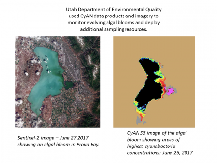
Due to the severity of Utah’s cyanobacteria blooms in 2016, EPA Region 8 requested technical assistance from EPA Office of Research and Development to utilize CyAN’s early warning indicator system to support cyanobacteria monitoring activities for the State of Utah. Satellite data products and imagery acquired approximately one week after the Utah Division of Water Quality’s (UDWQ’s) routine monthly sampling in mid-June identified that a bloom was developing in Provo Bay. Based on this information, UDWQ scientists returned to the area for follow-up sampling. Days later, they issued an advisory about a cyanobacteria bloom detected in Utah Lake, warning the public to keep themselves and their pets out of Provo Bay.
“The images we've been receiving through the CyAN project have been tremendously helpful to UDWQ. The near-daily spatial extent and relative magnitude coverage provides the foundation for a wide range of useful outputs,” said Benjamin M. Holcomb, Coordinator of Biological Assessment and HAB Programs with UDWQ.
Ben explained that by providing near-immediate alerts when cyanobacteria are reaching human health thresholds, CyAN gives organizations like UDWQ the ability to respond more quickly than if they were relying on public reports and monthly sampling. It also ensures that their in-situ, bloom-response data are representative of recent bloom conditions, which allows them to better target field sampling and more efficiently use their limited resources. Also, Ben added that the satellite images can be easily shared with response agencies as a useful visual communication aid.
The goal of this project is to provide access to satellite images and data on the concentration and extent of chl-a and cyanobacteria in the continental U.S. through an Android mobile application and other interactive resources. As CyAN continues to grow, so will scientists’ understanding of the connections between human health, economic values, and environmental conditions to cyanobacteria and phytoplankton blooms.