EPA Tool Helps Chicago Account for and Visualize Urban Water Flows
Published May 7, 2018
Urban water systems are necessarily complex. Delivering drinking water and treating sewage for millions of people, in addition to managing stormwater across hundreds of square miles, requires an extensive network of pipes, pumps, and treatment facilities. The buried and often hidden nature of this infrastructure adds to its complexity. This is a problem for municipalities seeking to manage water in more integrated and sustainable ways. New EPA software can help planning agencies and water utilities better understand the flows of water into, within, and out of their cities.
In an article published in Open Water Journal, EPA researchers explain how the CityWaterBalance software package can automate data gathering and synthesis for many water flows—precipitation, stream flows, water usage, etc.—freeing up city water managers’ time for deeper insight and planning.
EPA scientist and lead researcher, Laura Erban, Ph.D., believes that as more and more water data is shared online, tools like this will make it easier to account for unmeasured flows and uncertainties in urban water systems.
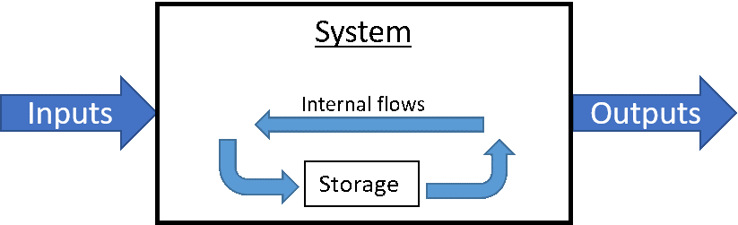
The concept behind this effort is simple. CityWaterBalance performs “mass balance” calculations on water flowing through a city. Water cannot be created or destroyed, so its mass must always be conserved. Flows and the amount of water stored in a system may change over time, but new water is never created out of thin air and it never simply disappears. Basically, CityWaterBalance does the job of an accountant, but for water.
Dr. Erban and her colleagues relied on this concept to create model flow equations for urban water flows and storages generally, and then used the example case of the greater Chicago area to test their work. The researchers consulted with local planning agencies and water utilities to help fill in in data gaps and build a complete understanding of the system. The flows calculated by CityWaterBalance and diagrammed below help shed light on the Chicago area water system, and can spur follow-up studies of specific components.
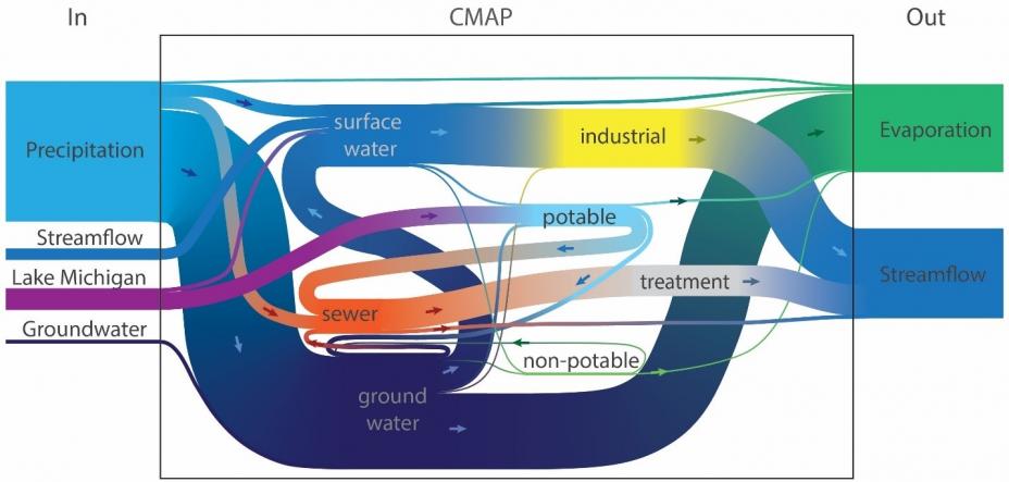 Urban water system evaluated using R package CityWaterBalance for water years 2001-2010 for the Chicago Metropolitan Agency for Planning (CMAP) region. Erban et al., (2018).
The system perspective illustrates how the engineered portion of Chicago’s water system is only part of the picture. Precipitation, evaporation, and other environmental flows matter a great deal.
Over the 10-year period of analysis, overflow of untreated sewage and stormwater during intense rain storms (shown as the flow from sewers directly into streamflow) is small compared to the volume passing through sewage treatment plants (sewer ⟶ treatment ⟶ streamflow). However, for brief stretches of time during and after these rain events, stormwater can overwhelm sewers causing major public health and environmental problems that Chicago and other cities with old sewage systems are still trying to address.
The flow diagram above represents recent, average annual conditions, but the tool can be readily applied to any time or spatial scale for which the user has data. After identifying a specific question that they want to examine more closely, a municipality can change the parameters and incorporate their local data with the data acquired from federal sources by CityWaterBalance. In the case of overflow of sewage and stormwater, a city might look at days with particularly heavy rainfall to see how the overall system changes during and after a storm event. Or, they may choose to look at specific neighborhoods where the problem is acute. More specialized tools can be incorporated, including stormwater and sewer system modelling software or cost-benefit analyses.
Planners can also alter inputs to explore future scenarios. Models predict that extreme wet weather events will become more likely over the coming decades. This trend will likely change how cities choose to manage stormwater. CityWaterBalance can help planners understand some of the cascading consequences that increased rain and various potential interventions may have.
Importantly, CityWaterBalance is completely open, accessible, and supports reproducible analysis.
“Transparency is vital when public funds and well-being are at stake,” says Dr. Erban. “CityWaterBalance makes it easy to see the big picture, a critical step toward systemic urban water management.”
Learn More
Download R package at CRAN
Download development version of R package at Github
Chicago Metropolitan Agency for Planning
Metropolitan Water Reclamation District of Greater Chicago
Sources and References
Erban, L. E., Balogh, S. B., Campbell, D. E., & Walker, H. A. (2018). An R Package for Open, Reproducible Analysis of Urban Water Systems, With Application to Chicago. Open Water Journal, 5(1), 3.