Helping to Engage Proctor Creek Community Members as Stewards of Their Watershed
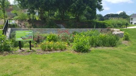 Rain garden at Vine City Park in Atlanta, Georgia. EPA worked with the Procter Creek community in Atlanta to create the Proctor Creek Story Map. Published October 26, 2020
Proctor Creek is an impaired waterway in Atlanta, Georgia, that experiences several overlapping environmental issues. The watershed has been troubled by frequent flooding, erosion, stormwater runoff, and pollution from illegal dumping. In addition, sewer overflows from the city’s combined sewer system, which carries both sewage and rainwater, and its sanitary sewer system, designed to carry sewage only, have impacted the creek. The Proctor Creek watershed is home to more than 38 neighborhoods, including some of the most economically disadvantaged and underserved areas in Atlanta.
Proctor Creek residents and stakeholders are taking action to help restore the watershed and create a healthier, cleaner and more prosperous place to live, learn, work, and play. EPA is working in collaboration with these community champions to improve and protect the health of Proctor Creek and to empower community revitalization (community-led economic, social, and ecological revitalization) in the watershed.
One recent effort undertaken was the development of the Proctor Creek Watershed Story Map, an interactive online tool that combines maps with narrative text, images, and multimedia content to convey information as a story and inform and connect with viewers. The Story Map was developed, in collaboration with Proctor Creek residents and stakeholders, to provide resources and share important information about the Proctor Creek watershed and the role that green infrastructure can play in the community.
“This community-driven Story Map provides an excellent platform to share the rich history of the Proctor Creek community and the outstanding work done by community champions to address some of the environmental challenges they have faced. The tool communicates local knowledge and highlights green infrastructure initiatives that have been undertaken in Proctor Creek to help restore the watershed and protect its residents,” explained EPA scientist Shannon Griffin. “The Map also illuminates the environmental and public health benefits of green infrastructure and helps to inform community decision-making efforts.”
The interactive tool explores community-identified concerns, such as flooding, water quality, urban heat islands and mosquitoes, and discusses how the environmental challenges being experienced in the community are connected to public health. Additionally, it shares what is already being done at the neighborhood, city, and state level to address these challenges and highlights actions that community members can take.
One of the potential solutions emphasized in these challenges and concerns is green infrastructure – a practice that uses plants, soils, and other natural features to manage wet weather impacts, reduce and treat stormwater at its source. Using green infrastructure can reduce a community’s exposure to harmful substances and conditions, such as water pollution, flooding, air pollution, heat, and noise. Green infrastructure can also provide opportunity for recreation and physical activity, improve safety, promote community identity and a sense of well-being, and provide economic benefits at both the community and household level. All of these impacts can directly or indirectly influence public health.
The Story Map examines the proposed expansion of green infrastructure throughout the Proctor Creek watershed, evaluates the potential impacts of this expansion on environmental and public health, and highlights areas in the Proctor Creek community that may benefit from green infrastructure practices.
In addition to examining the intersection of green infrastructure and health and providing tools and resources for expanding green infrastructure throughout the watershed, the Story Map also provides resources about demographics and public health in Proctor Creek and addresses additional concerns raised by the community, including illegal dumping of trash and tires, and brownfields.
The Proctor Creek community can use this tool as an important resource to engage in future decision-making and planning efforts that impact the watershed and its residents. This tool will equip residents with the knowledge to advocate for a healthier, more sustainable community. Communities will be able to use this tool in school outreach and learning efforts, as well as educational efforts for the general public.
"For years, Proctor Creek residents have elevated community concerns about environmental and health challenges in the watershed and invested decades of sweat equity to address those concerns,” explained Na ’Taki Osborne-Jelks, a community leader in Proctor Creek. “This Story map helps to tell some of that story by centering both historical and ongoing challenges that have, in the past, and continue to plague the watershed today. Perhaps more importantly, it also offers tools that community members can pursue, in collaboration, with government and other stakeholders to help achieve a swimmable, fishable, playable Proctor Creek and a restored community and people."
Learn More
Urban Waters and the Proctor Creek Watershed/Atlanta (Georgia)