Launch of Village Blue Web Application Shares Water Monitoring Data with Baltimore Community
Published February 26, 2018
EPA and the U.S. Geological Survey (USGS) have launched their mobile-friendly web application for Village Blue, a project that provides real-time water quality monitoring data to the Baltimore, Maryland community. The web application displays multiple current water quality conditions collected via two sensors mounted underwater in Baltimore Harbor.
EPA and USGS initiated the Village Blue project to increase public awareness about local water quality, and give citizens and professional scientists more data to inform communities, policies and environmental restoration efforts.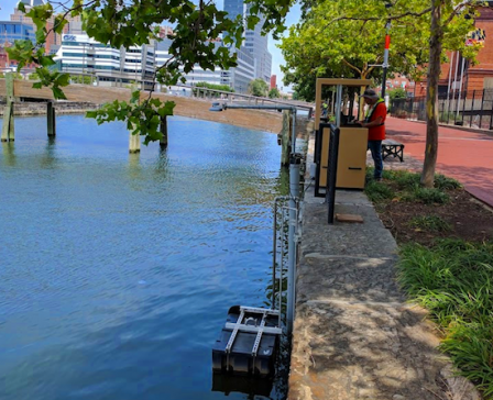 Village Blue's water quality sensors are mounted underwater in Baltimore's Jones Falls River, shown here. The data collected by the sensors is stored and transmitted by equipment housed in this weather-proof box (foreground).
Researchers are also using the multiple Village Blue sensors to develop data analysis approaches that will improve the understanding of stormwater impacts on nutrients and indicators of sewer overflows using the follow sensor data:
- gage height;
- stream velocity;
- turbidity;
- salinity;
- dissolved oxygen;
- nitrate;
- temperature; and
- pH.
“Our goal is to work together with the Baltimore community to use real-time water sensors to raise awareness of the importance of water quality,” said EPA scientist Gary Norris, a project lead.
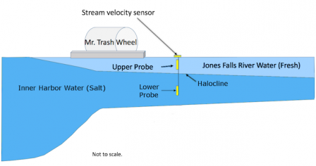 Jones Falls sensor placement in relation to the halocline.Village Blue’s water quality monitoring site is located where the Jones Falls River in Baltimore meets Baltimore’s Inner Harbor. In this location, the water is about eight feet deep and separated into a top layer, made of fresh water from the river, and a bottom layer, made of salt water from the harbor. This layered effect is caused by the denser salt water sinking below the fresh surface water.
One sensor is mounted two feet below the surface to monitor the fresh water from the river, while the other is mounted six feet deep to monitor the salt water from the harbor. The area that forms the division between fresh and salt water is called a halocline.
The underwater sensors are connected to probes that record measurements every five minutes to monitor the Jones Falls and Inner Harbor water quality. Collected measurements are displayed on EPA’s interactive Village Blue website, with the goal of providing the community with insights into the relationship between water quality and the external environment.
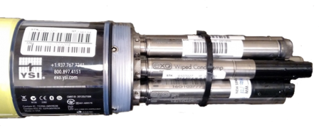 Village Blue's water quality sensors use multiple probes to measure various characteristics of water in the harbor.EPA is partnering with several local and state organizations to implement the Village Blue project and raise public awareness about the importance of monitoring and protecting local waters. Project partners include Blue Water Baltimore; City of Baltimore; Maryland Department of Natural Resources; Maryland Science Center; National Aquarium; USGS; and Waterfront Partnership of Baltimore. EPA and project partners will be engaging with citizen and professional scientists, community groups and K-12 school groups in using data from Village Blue to learn about water quality in the Baltimore Harbor.