Mapping Underwater Vegetation in the Delaware Estuary
Published July 6, 2020
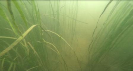 A bed of Wild Celery (Vallisneria americana) observed during a verification dive conducted by the EPA Mid-Atlantic Region’s Scientific Dive Unit. The Delaware River is the longest un-dammed river in the United States east of the Mississippi, extending 330 miles from Upstate New York to the mouth of the Delaware Bay and into the Atlantic Ocean. Over 15 million people (roughly 5 percent of the nation's population) rely on the waters of the Delaware River Basin for drinking, agricultural and industrial use.
In the Delaware Estuary, where the fresh water of the Delaware River mixes with the salty water of the Delaware Bay, seagrasses and other types of submerged aquatic vegetation are an important part of the ecosystem. Submerged aquatic vegetation provides a crucial habitat for many aquatic organisms, including fish, crustaceans, shellfish and other commercially important species. The small creatures that live among the grass beds are important food sources for larger aquatic species and birds, but the benefits don’t stop there. Underwater vegetation also absorbs nutrients, traps sediment, buffers wave energy during storm events, and produces oxygen.
While underwater grasses provide a wide range of benefits, they are also very sensitive to changes in water quality. These grasses rely on sunlight that filters through the water in order to grow. When waterways become clouded with high levels of nutrients and sediments, the grasses can’t get the sunlight they need to survive.
“When healthy, seagrasses provide many ecosystem services including processing nutrients, trapping sediments, sequestering carbon, etc. However, once you have water quality impairment, you can’t plant grasses to mitigate these issues, because they won’t take (i.e., the grasses will die),” says Marguerite (Peg) Pelletier, a researcher in EPA’s Center for Environmental Measurement and Modeling.
For this reason, underwater grasses can be used as a good sentinel for assessing the overall health of an ecosystem. In areas where underwater grasses are present and thriving, you can conclude that water quality is generally good.
In the Delaware Estuary, EPA is working with local partners to better understand the extent to which development in the surrounding area may be impacting the health of the estuary. The communities along the Delaware River face a number of environmental challenges, including issues with stormwater management, erosion and flood control, source water protection, and habitat loss.
“The Delaware River has a rich history as a working river, providing many ecological and economic benefits to the Mid-Atlantic region’” says Kristin Regan and Kelly Somers, members of EPA Mid-Atlantic Region’s submerged aquatic vegetation team working in the Delaware Estuary. “We want to better understand what characteristics of the River contribute to healthy and clean waters, and the first step was to determine if, and where, these ecologically important vegetation beds are growing.”
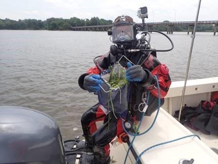 A scientific diver from the EPA Mid-Atlantic Region’s Scientific Dive Unit displays Wild Celery (Vallisneria americana) collected during a verification dive. In 2017 and 2018, EPA Mid-Atlantic Region researchers conducted field surveys along the Delaware River and Bay shores. The researchers used hydroacoustic monitoring devices to collect information about the geographic range and density of the vegetation beds. The hydroacoustic device is like the types of “fish finders” used by fishermen and other boaters, but this device is more advanced and finely tuned to detect vegetation beds instead of fish. The device hangs over the side of the sampling vessel and emits a beam of soundwaves down into the water. The device recaptures the sound as it reflects off objects. Based on the strength of the reflected sound, the device can differentiate between a vegetation bed and the surface of the river bottom. The device can also determine the water depth and height of a seagrass bed by measuring the amount of time it takes to recapture the sound. Together, this information provides a comprehensive picture of vegetation distribution and density.
For this study, divers also collected raking samples to verify the hydroacoustic data with direct observation. These dives and samples provided an opportunity to collect information about vegetation species and the presence of other important organisms such as mussels.
This effort began through coordination with the Delaware Estuary National Estuary Program – the Partnership for the Delaware Estuary, which identified submerged aquatic vegetation as a critical part of their Comprehensive Conservation and Management Plan (CCMP). The CCMP is a blueprint that guides future decisions and establishes priorities for activities, research and funding to address environmental protection issues in the estuary. The CCMP is based on a scientific characterization of the estuary and is developed and approved by a broad coalition of stakeholders.
The final results and data from this project will be used to create a comprehensive map of submerged aquatic vegetation throughout the Delaware Estuary. This map will be shared with EPA partners and stakeholders to assist with other aquatic habitat assessments, support restoration efforts, and inform regulatory decisions made throughout the Delaware River.