Pre-Modeling Tool Helps Guide Contaminated Site Cleanup Plans
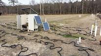 Electrical resistivity field survey. Photo credit to: J.L. Robinson/Rutgers State University of New Jersey.Published January 24, 2018
A major EPA priority is to advance the cleanup of contaminated sites. EPA researcher Dale Werkema and collaborators at the U.S. Geological Survey recently released an easy-to-use, spreadsheet-based tool to help site managers and others explore the value of using electrical resistivity imaging (ERI) before investing time and money into the technique to guide cleanup activities.
While a powerful tool for creating maps of subterranean conditions such as underlying soil, bedrock, groundwater, and contaminant distribution, ERI typically involves intensive field work followed by expert modelling and evaluation. That work, in turn, can then show where to target remediation activities, develop conceptual site models, and inform decision makers. With the new, “Scenario Evaluator for Electrical Resistivity (SEER) Survey Pre-Modeling Tool,” users can perform quick, simple preliminary resistivity models right at their desktops before deciding to invest in full-scale ERI surveys. SEER is designed to have broad utility in industry, academia, and research.