Delineate the Source Water Protection Area
This page provides information about delineating source water protection areas (SWPA) to be assessed and protected as part of a source water protection program. Learn more about other components of source water protection programs.
On this page:
- What is a Source Water Protection Area?
- Delineation for Groundwater Sources
- Delineation for Surface Water Sources
What is a Source Water Protection Area?
 Delineate the Source Water Protection AreaThe first step in completing a source water assessment (SWA) is to delineate (or map) the land area that contributes water to the drinking water supply and where pollution from human activities or natural sources poses the greatest threat to source water quality. This delineated area is often called a source water protection area (SWPA) or zone of concern. The SWPA designates the area within which a water system will conduct a potential contaminant source inventory (Step 2).
The size of the SWPA may vary based on a variety of hydrogeological, environmental, regulatory, and management factors. Methods for delineating groundwater sources can differ widely from those for delineating surface water sources. Whether surface or groundwater source, it is important to regularly evaluate and redefine SWPAs and zones to account for land use changes, water monitoring data, and new information.
Water systems can ask for help when completing delineations. State public health and environmental agencies, federal agencies (e.g., the Natural Resources Conservation Service (NRCS), United States Geological Survey (USGS), or EPA), state cooperative extension services, water associations, conservation districts, universities, and private organizations may all provide technical assistance and/or data to complete delineations.
Find additional technical resources, guidance, and links to mapping and modeling tools.
Delineation for Groundwater Sources
Drinking water systems use information about the flow of underground water and surface-to-ground interactions to delineate (or map) groundwater source protection boundaries (also known as a wellhead protection area). The amount of precipitation, soil porosity, presence of Karst topography, location of groundwater recharge areas, urbanization, well design, and other site-specific factors may all inform the location of wellhead protection area boundaries. By mapping the boundaries, drinking water systems will be able to identify the land areas where spilled or discharged pollutants could filter through the surface into the groundwater source.
Drinking water systems may choose to segment wellhead protection areas to identify relative zones of concern. The purpose of these zones is to define portions of the wellhead protection area where activities have a higher risk of contaminating the source water and where aquifer conditions and land surface activities should be more closely evaluated. Boundaries of these zones are often based on the time it takes underground water to reach the well or to account for locations of known contaminant sources. For example, watershed areas closest to a well are often considered areas of higher concern.
Various methods are used to delineate groundwater-based SWPAs. In order of increasing accuracy and complexity, common methods include:
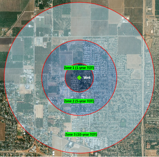 Delineations are often described as a buffer distance from a well or intake structure and expressed in Time of Travel (TOT) (e.g., a 2-year TOT refers to a distance from a well where it will take 2 years for water or contaminants to reach the well). Water systems may choose to divide SWPA's into relative zones of concern. Arbitrary Radial Distance – The simplest method for delineating a wellhead protection area, this approach involves drawing a circle (or circles) with an arbitrary fixed radius around the well. The radius of the circle may be determined by an evaluation of local hydrogeological conditions, such as soil porosity or groundwater flow rate.
- Calculated Fixed Radius – This method defines a circular area around the well, which is an estimate of area overlaying the groundwater that will be pumped over a certain period. The radius of the circle depends on the time it takes groundwater to travel from the edge of the circle to the well, which is calculated using an algebraic equation with readily available data inputs (e.g., pumping rate, aquifer porosity). Utilities can use this approach to define concentric zones of concern based on Time-of-Travel (TOT) estimates (e.g., 6 –month, 1-year, 5-year TOT zones).
- Analytical Methods – With this method, wellhead protection areas are delineated by using equations to define groundwater flow and/or contaminant flow and transport to the well. A system analytical model, such as EPA's WHPA Code, can often provide a close approximation of TOT boundaries.
- Hydrogeologic Mapping – This approach uses geological and/or geophysical data to map delineation area(s). This method requires a high level of professional expertise and access to geologic data and technical reports, but is suitable in areas with complex geologic formations (e.g., Karst, fractured rock).
- Numerical Flow or Flow-and-Transport Computer Models – This approach uses computer models to determine groundwater and/or contaminant flow and transport. EPA WhAEM and USGS MODFLOW model are examples of computer models.
Some of these methods are more scientifically complex and accurate than others. The appropriate option (or combination of options) will depend on a range of site-specific conditions, including access to technical resources, availability of data (e.g., hydrogeologic data), cost, and the desired level of effort. Certain sources may require a more accurate delineation method (for example if the hydrogeological setting contains Karst formations or if there are high-risk potential contaminant sources).
Find additional technical resources, guidance, and links to mapping and modeling tools.
Delineation for Surface Water Sources
For surface water sources, water systems identify the land area in the watershed upstream of an intake. The source water protection area (SWPA) boundary generally is described using a topographic map connecting the highest points uphill of the drinking water intake from which overland flow drains to the intake.
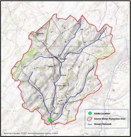 A Geographic Information System (GIS) or a topographic map can be used to delineate watershed areas upstream of a drinking water intake facility. In large watersheds, water systems may elect to divide SWPAs into segments or zones, identifying smaller high-priority sub-watersheds for more focused assessment. These may include areas closest to the intake, where contamination sources are more likely to affect source water quality, as well as other, more distant areas that contain significant contaminant sources. Water systems use various methods to delineate surface water-based SWPAs, such as:
- The entire watershed or hydrologic unit containing the intake;
- Stream Time-of-Travel (TOT) distances upstream of the intakes (i.e., containing stream length and watershed area);
- Arbitrary distances upstream or around the intake; and
- Buffer zones.
Find additional technical resources, guidance, and links to mapping and modeling tools.