Streamflow Duration Assessment Method (SDAM) Status by Region
Currently, the EPA and partners are developing or modifying existing SDAMs for use across the U.S.
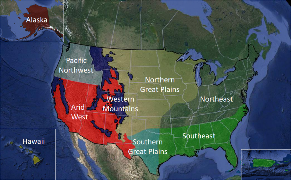
Map of Study Regions

Map of SDAM study regions, based on regions identified in the U.S. Army Corps of Engineers Ordinary High Water Mark Scientific Support Document (figure modified from Wohl et al. 2016).
Regional Updates
Pacific Northwest
The SDAM for the Pacific Northwest was developed through a partnership between the U.S. EPA, the U.S. Army Corps of Engineers, and Oregon’s Department of State Lands. The method was drawn from a study conducted on 264 stream reaches across the range of hydrologic landscapes of Oregon, Idaho, and Washington.
Arid West
A beta SDAM is under development based on analysis of data collected at 100 sites across the region. Release of the beta method is anticipated in early winter; it will be available for user comment for one year. Additionally, two case study watersheds were identified in southern California and Arizona. Four to six reaches within each case study watershed were instrumented with conductivity loggers that recorded the presence or absence of water or United States Geological Survey stream gages to better understand the spatial scale at which field indicators reflect streamflow hydrology. Sampling at instrumented sites will continue on an annual basis to ensure that method development was not biased by interannual climatic and streamflow variation.
Western Mountains
A total of 140 stream reaches are being sampled as part of baseline and validation data collection. Forty baseline reaches were instrumented with conductivity loggers in the summer of 2019. One hundred validation reaches were visited in summer of 2020 along with a second visit to Western Mountain baseline sites. During each site visit, a rapid field assessment was conducted that used hydrological, geomorphological, and biological candidate indicators of streamflow duration. Candidate indicators for the protocol were identified through a literature review of existing streamflow duration methods and indicators used throughout the U.S. and considered for applicability to the Western Mountains.
Great Plains
A total of 290 sites are being sampled as part of baseline and validation data collection. One hundred and eighty baseline reaches were instrumented with conductivity loggers in October of 2019 and will be visited two more times by November 2020. One hundred and ten validation reaches were visited in spring and summer 2020. During each site visit, a rapid field assessment is conducted that uses hydrological, geomorphological, and biological candidate indicators of streamflow duration. Candidate indicators were identified through a literature review of existing streamflow duration methods and indicators used throughout the U.S. and considered for applicability to the Great Plains.
Northeast and Southeast (including Puerto Rico and U.S. Virgin Islands)
Preparation for baseline data collection and validation site sampling is underway. Candidate indicators were identified through a literature review of existing streamflow duration methods and indicators used throughout the U.S. and considered for applicability in the Northeast and Southeast. Two hundred and forty baseline reaches are planned to be instrumented with conductivity loggers in 2020 and will be visited two more times by fall of 2021. An additional one hundred and sixty validation reaches will also be visited throughout both regions by fall of 2021.
Alaska, Hawaii, and the Pacific Island U.S. Territories
Candidate indicators will be identified through a literature review of existing streamflow duration methods and indicators used throughout the U.S. and considered for applicability in Alaska, Hawaii, and the U.S. Territories in the Pacific Ocean.
