SJRWP
San Jacinto River Waste Pits Superfund Site
Harris County, Texas
Announcements and Key Topics
Appendices for Northern Impoundment 30% Remedial Design:
Background
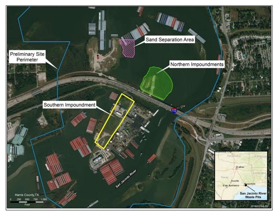
The San Jacinto River Waste Pits Superfund site, located in Harris County, Texas (Figure 1), consists of two sets of impoundments, or pits, built in the mid-1960s for disposing solid and liquid pulp and paper mill wastes that are contaminated with dioxins and furans. The northern set of impoundments, about 14 acres in size, are located on the western bank of the San Jacinto River, north of the Interstate 10 (I-10) bridge over the San Jacinto River. These northern impoundments are partially submerged in the river. The southern impoundment, less than 20 acres in size, is located on a small peninsula that extends south of I-10.
The northern impoundments were covered with an armored cap in 2011 as a Time Critical Removal Action as a temporary way to contain the contaminants.
On October 11, 2017, EPA approved the cleanup plan to address dioxin contamination at the site. The selected remedy includes removal of the dioxin containing material from the waste pits and off-site disposal. The EPA’s cleanup plan includes installing engineering controls such as a cofferdam before excavating approximately 212,000 cubic yards of dioxin contaminated material for disposal. The estimated cost for the remedy is $115 million.

Final Listing Date: 3/19/2008
Cleanup Activities
EPA reached a settlement with the responsible parties in April 2018 for the completion of a Remedial Design for the remedy selected in the October 2017 Record of Decision. The settlement agreement, referred to as an Administrative Settlement Agreement and Order on Consent for Remedial Design, lays out the deliverables that the responsible parties will submit to EPA and the due dates for the deliverables. EPA, in cooperation with support agencies are participating in a series of technical work group meetings with the responsible parties to ensure technical issues are resolved quickly and the design schedule is maintained.
In addition to conducting the Remedial Design, the responsible parties also conduct quarterly inspections of the armored cap cover, fencing, signage, buoys, and security cameras installed for the Time Critical Removal Action. The most recent quarterly inspection reports are provided below.
Following Tropical Storm Imelda’s landfall on the Texas coast on September 17, 2019, heavy rains and flooding occurred throughout southeastern Texas. On Friday, September 20, nine barges broke loose from their moorings in the San Jacinto River upstream of the San Jacinto River Waste Pits. One of these barges became grounded on the armored cap over the eastern cell of the Time Critical Removal Action site. The grounded barge was lightened of its load and removed from the armored cap on Monday, September 23, 2019, under the incident command and supervision of the U.S. Coast Guard. Representatives from EPA, McGinnes Industrial Maintenance Corporation, and International Paper Company were on site to coordinate with U.S. Coast Guard during the planning for and removal of the barge.
Following removal of the grounded barge, the responsible parties’ contractor performed a survey of the armored cap as required by EPA, and in accordance with the Time Critical Removal Action Operations, Monitoring, and Maintenance Plan The post-storm bathymetric survey revealed two areas (Channel Areas) outside the footprint of the Armored Cap, in the river channel adjacent to the Armored Cap where riverbed elevations had decreased, relative to the July 2019 quarterly inspection survey. The Channel Areas were located in the vicinity of where the barge was grounded. Based on probing work conducted on the Time Critical Removal Action cap and in the channel areas, there was no indication that any release of waste material from beneath the armored cap had occurred associated with the decrease in riverbed elevations in the two Channel Areas adjacent to the armored cap. Between March 23 and April 9, 2020, additional rock was placed in the Channel Areas to further protect the edge of the armored cap by providing additional slope stabilization and scour protection at those locations.
Between May 20 and June 21, 2019, a contractor for the responsible parties conducted slope enhancement work on the northwest slope of armored cap. The slope enhancement work included the installation of approximately 4,100 square yards of articulated concrete block mat on the northwestern submerged slope of the Time Critical Removal Action cap.
Community Engagement
Site Documents
-
Administrative Settlement Agreement and Order on Consent for Remedial Design Document
-
Post-Tropical Storm Imelda Channel Maintenance Completion Report
-
Post-TCRA Quarterly Inspection Report – January/February 2020
-
Administrative Settlement Agreement and Order on Consent for Remedial Design Document
-
San Jacinto Responses to the National Review Board (NRRB) Recommendations Memo
-
Post-TCRA Quarterly Inspection Report Memorandum – January 2017
-
San Jacinto River Channel Slope Maintenance Completion Report Memorandum – March 10, 2017
- U.S. Army Corps of Engineers: Evaluation of the San Jacinto Waste Pits Feasibility Study Remediation Alternatives (August 2016)
- San Jacinto Community Meeting Presentation
- Post-TCRA Quarterly Inspection Report April 2016
- Frequently Asked Questions
- Draft San Jacinto Community Involvement Plan
