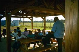
What Communities are Doing
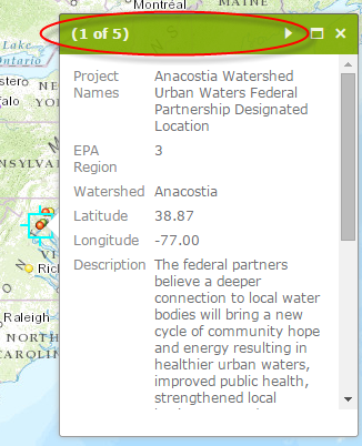
View More Than One Project per Map Pop-up
When clicking on a group of project points, it is easy to scroll through the project information within the same pop-up. Click on the arrow symbol in the top part of the pop-up to the right of the "1 of " heading (highlighted by a red oval in the below screenshot):
Communities across the country are coming together, working with EPA, state, and local agencies, and taking steps to access, restore, and benefit from their urban waters and the surrounding land. Read below to find a description of projects in your area.
This Urban Waters locations map indicates places where EPA and federal, state and/or local partners are collaborating. Locations are displayed in layers representing:
- EPA’s Urban Waters Small Grants;
- Urban Waters Fellows supported by EPA, River Network and Groundwork USA; and
- Urban Waters Federal Partnership locations
Note about projects eligible for grants: Some of the projects displayed on this map were undertaken prior to the Urban Waters Small Grants. These projects typically received funding from a variety of sources. As such, there may be activities noted below that are not eligible for funding under the Urban Waters Small Grants Request for Proposals (RFP). Please see the current RFP to identify eligible activities for the current cycle of grants.
On this page:
- Small triumphs build big hopes for Greater Boston's "Big River"
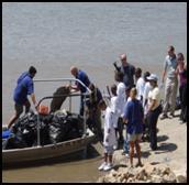
- Caño Martín Peña, San Juan, Puerto Rico
- Anacostia River, Washington, D.C./Maryland
- Turkey Creek Greenway Project, Gulfport, Mississippi
- Green Infrastructure in Urban Neighborhoods, Milwaukee, WI and Cincinnati/Cleveland, OH
- Protecting Drinking Water and Surface Water in the Albuquerque Metropolitan Area, New Mexico
- Blue River Watershed/Brush Creek, Kansas City, Kansas/Missouri
- South Platte River, Denver, Colorado
- Santa Cruz Watershed, Tucson, Arizona
- Columbia River Basin, Washington/Oregon/Idaho
Small triumphs build big hopes for Greater Boston's "Big River"
Successes help create momentum for Mystic River Watershed restoration
Longtime residents around the Mystic River can remember the days when the Boston-area waterway was a popular swimming hole where families could cool off on a hot day. Once an abundant fishery and a place of natural beauty that was memorialized in the poem "Over the River and Through the Woods," the Mystic faces significant problems from years of industrial use, pollution and neglect. Now efforts are underway to restore the heavily traveled and industrialized "big river" — the literal translation of its Wampanoag name "muhs-uhtuq" — to its heritage as a community focal point.
In highly industrialized areas, urban residents have almost no access to their waters. Creeks and streams are often turned into culverts to make way for roads and hide polluted waters. Valuable waterfront property belongs mainly to big industry, and in the lower Mystic Watershed, industrialization is so intense that the neighboring communities have only two tiny parks — one for each side of the river. In these segments, water recreation is currently restricted because the area is designated for port activity, and is considered unsafe for recreational boats, with tanker ships and barges often coming in and out, transporting the region's heating oil, jet fuel, and road salt.
"People often don't have a strong sense of connection to their river," said Caitlyn Whittle, EPA environmental scientist with EPA's Region 1 office in Boston. "It's not viewed as a resource."
This historic watershed suffers from bacteria, nutrient, and legacy pollution (e.g. heavy metals). Three Superfund sites reside along the watershed's headwaters and have had an impact on sediment and water quality. In addition, the urban and historic nature of the Mystic lends itself to winding through very old cities and towns. These old towns' failing, crumbling and outdated infrastructure, coupled with urban and stormwater runoff, have resulted in high bacteria and nutrient loads.
With 21 distinct communities in the watershed and multiple pollution issues affecting the watershed, pooling restoration efforts has been difficult, but not impossible, and those efforts are bearing fruit.
From expanding riverfront recreation to reducing pollution to increasing water-quality monitoring, restoration activities in the Mystic River Watershed are beginning to show significant successes, including stepped up enforcement that put an end to the dumping of more than 10,000 gallons of sewage a day into the river. With each sign of progress, momentum is building, with additional local community organizations and state and federal agencies joining the work on behalf of the long-neglected river and its tributaries.
In an effort to reduce bacteria loading, track progress and raise awareness about pollution in the Mystic River Watershed, EPA has issued the watershed a report card for the past four years. Focusing solely on bacterial pollution, this report card compares the Mystic watershed to state swimming and boating standards. For 2006 and 2007, the watershed received a grade of D, while in 2008 and 2009, EPA announced a slight improvement and gave the watershed a C-, indicating that the water was safe for swimming 57% of the time and safe for boating 93% of the time.
"The ongoing efforts to restore the Mystic River Watershed have helped area residents start to appreciate the river's potential as a community asset," Whittle said. "Local residents are beginning to see how the river could again become a source of pride and enjoyment throughout the region."
"It's a long road," Whittle said, "But we're making a collaborative effort with community and state agencies, and more people are seeing they have a vested interest in the outcome."
Accomplishments achieved by the local, state and national groups working to improve the Mystic River include:
- In April 2008, more than 150 people attended a Mystic River Watershed Summit that focused on flooding, industrial contaminants, bacteria and stormwater, and reconnecting people to the river.
- EPA New England has loaned over $5,000 worth of monitoring equipment to the Mystic River Watershed Association in support of baseline and hot spot monitoring programs.
- EPA enforcement efforts have stopped more than 10,000 gallons of sewage per day from being discharged to the watershed through illicit connections.
- Massachusetts Environmental Trust awarded a total of $508,500 through their license plate program to five projects to improve public access to the Lower Mystic River through creating, expanding or enhancing opportunities for biking, hiking, walking, non-motorized boating, picnicking and other riverfront outdoor public recreation in the Lower Mystic River Watershed.
- In 2010, EPA New England and the University of Massachusetts - Boston began a new partnership on urban water quality research, monitoring, assessment, and analysis with other local universities.
Partners pull together to restore Mystic River Watershed
Nearly two dozen partners have worked to get the Mystic River Watershed effort under way and to keep its momentum going strong. Partners in the effort include:
- Alternatives for Community and Environment, Roxbury, MA Exit
- Charlestown Waterfront Coalition, Charlestown, MA Exit
- Chelsea Greenspace, Chelsea, MA Exit
- City of Chelsea Exit and Town of Winchester Exit representing all 21 municipalities
- Conservation Law Foundation Exit
- Friends of the Alewife Reservation, Arlington/Cambridge, MA Exit
- Friends of Upper Mystic Lake, Winchester/Medford, MA Exit
- Groundwork Somerville, Somerville, MA Exit
- La Comunidad, Inc., Everett, MA Exit
- Massachusetts Department of Conservation and Recreation Exit
- Massachusetts Department of Environmental Protection Exit
- Massachusetts Department of Public Health Exit
- Massachusetts Department of Transportation Exit
- Massachusetts Executive Office of Energy and the Environment Exit
- Massachusetts Port Authority Exit
- Massachusetts Water Resources Authority Exit
- Metropolitan Area Planning Council Exit
- Mystic River Watershed Association Exit
- Neighborhood of Affordable Housing, East Boston, MA Exit
- Tri-Community Action Program, Malden, MA Exit
Caño Martín Peña, San Juan, Puerto Rico
Caño Martín Peña (Martín Peña Channel, or MPC) is a 3.75 miles long channel that provides a natural connection between San José Lagoon and San Juan Bay. In the early 20th century, as the Puerto Rican economy evolved, impoverished squatters began filling the wetlands at the margins of the canal with garbage and debris to build their homes. This practice continued for decades. The canal provides a waterway for the operation of an aquatic mass transit system. However, the continued practice of filling in the banks of MPC with trash and other refuse reduced eastern half of MPC depth of a few inches in some areas. This has resulted in a severe disruption of the natural water flow and circulation within the San Juan Bay estuary system. Furthermore, over 3,000 structures discharge raw sewage into MPC through direct pipes, ditches and the stormwater system. Mercury, lead and PCBs have been detected in concentrations of concern. The frequent flash flooding of the area during rain events directly expose residents to these contaminated waters on a regular basis. Since EPA designated the San Juan Bay Estuary as an Estuary of National Importance in 1992, data has been steadily collected. The San Juan Bay Estuary Program (SJBEP) was instrumental in raising awareness among government agencies, communities and the general public about how the restoration of the MPC could have a positive impact on the whole San Juan Metropolitan area. In 2007, the Governor of Puerto Rico signed a Land Use and Comprehensive Development Plan for MPC. The Plan incorporates dredging the MPC to improve flow and reduce flooding hazards, promote biodiversity, and restore the SJBE.
Project Description
Previous initiatives to rehabilitate the MPC overlooked the relationship between environmental degradation and poverty. Most residents of designated relocation areas do not want leave their neighborhoods. The MPC environmental restoration project, through its dredging and other infrastructure works, depends on the rehabilitation of existing homes and the development of new housing. The project was designed to emphasize that whenever possible, housing opportunities within the communities must be provided for those families wishing to remain in the area. Economic development and education are important concerns. The ultimate goal of the MPC project is to restore the health of the ecosystem while attaining social and environmental justice. It is probably the most important comprehensive development initiative currently underway in Puerto Rico. Some of the project components are: channel dredging; relocation of families; wastewater and drinking water infrastructure; and the improvement of socio-economic conditions.
Achievements and Accomplishments
Over 18 technical studies needed to comply with environmental regulations for the dredging of MPC have been completed. Through enforcement actions against the Puerto Rico Aqueduct and Sewer Authority (PRASA) EPA was able to significantly reduce the flow of sewage from the financial district into the MPC. Surface debris clean-up activities have been completed. As a result of understanding the unhealthy state of the MPC, residents have understood the need for its dredging and have become the Project's strongest allies. Almost 300 household relocations have been completed.
Partners
- Cantera Peninsula Development program Exit
- U.S. Department of Housing and Urban Development Exit
- U.S. Department of Transportation Exit
- U.S. Department of Education Exit
- U.S. Department of Energy (DOE) Exit
- Department of Agriculture (USDA) - Urban Forestry Exit
- U.S. Small Business Administration (SBA) Exit
- U.S. Geological Survey (USGS) Exit
- U.S. Department of Commerce Exit
- San Juan Bay Estuary Program, ENLACE Project Exit
- Martín Peña Channel Community Land Trust
- G-8, Inc.
- Cantera Peninsula Development Company
- Proyecto ENLACE Exit
- Puerto Rico Department of Natural and Environmental Resources Exit
- Puerto Rico Environmental Quality Board Exit
- Puerto Rico Planning Board Exit
- Puerto Rico Aqueduct and Sewer Authority Exit
- Puerto Rico Electric Power Authority Exit
- InterAmerican University of Puerto Rico Exit
- San Juan Bay Estuary Program Exit
- Sacred Heart University Exit
- Polytechnic University Exit
- University of Puerto Rico Exit
- Many local businesses and community organizations
Anacostia River, Washington, D.C./Maryland
The Anacostia River's challenges encompass the entire watershed — 176 acres of land in Washington, DC, and Montgomery and Prince George's Counties in Maryland that drains surface water into the river. The river's tributaries struggle with large quantities of polluted runoff that blight the landscape and lead to flooding, erosion, and infrastructure damage, compromise the health of the entire ecosystem, and threaten public health. These tributaries also deposit tons of trash and sediment into the river annually.
Project Description
Below is a brief overview of some of the ongoing work that will continue to improve the water quality of the river:
- Anacostia Watershed Restoration Plan
A comprehensive watershed restoration plan for the Anacostia (ARP) was completed in 2010. EPA's Region 3 office in Philadelphia, through its participation as a member of the Anacostia Watershed Restoration Partnership, helped to coordinate the development of the ARP and will help with its future implementation. - Combined Sewer Overflow (CSO) Long Term Control Plan (LTCP)
Under a federal consent decree, EPA will continue to monitor and enforce the obligations of District of Columbia Water And Sewer Authority (DC Water) in controlling overflows per the authorized Long Term Control Plan; a 96% reduction or capture of CSO flows in an average year will result from this 20-year agreement. These provisions will have a dramatic effect on the quality of the tidal river. - CSO Controls and Funding
A $1,746,000 earmark grant was awarded to DC Water to perform sewer separation work that would address a CSO problem at Outfall 006 along the Anacostia River. EPA will continue to work with the grant recipient to ensure that grant requirements are met. - TMDL Approvals and Support (DC and MD)
The District Department of Environment and Maryland Department of Environment along with members of several non-governmental organizations worked collaboratively with EPA to develop a trash TMDL for the Anacostia River. To restore water quality, the TMDL requires capturing or removing more than 600 tons (1.2 million pounds) of trash from the watershed annually. - MS4 Permits
EPA will oversee the green infrastructure and TMDL permit conformance with the DC MS4 permit through required monitoring, modeling, and evaluation and will work with DC to update the permit as necessary. The TMDL implementation plans will be updated pursuant to this permit and will be reviewed by EPA for adequacy. EPA is in discussions with Maryland about revising language for addressing MS4 permit storm water controls and water quality standards compliance in Montgomery and Prince George's Counties. This includes working with both jurisdictions to support an integrated storm water management approach to address interstate urban storm water issues. EPA is also working with Maryland on more restrictive language to determine how TMDLs are to be incorporated and managed in the storm water permits. - Blue Plains Permit
The 2003 permit, which had been administratively extended since February of 2008, was reissued in August, 2010. The reissued permit include conditions incorporating the requirements of the TN/WW Plan and a schedule for completion of necessary projects. - Washington Sanitary Sewer Commission (WSSC)
A Consent Decree was on July 26, 2005, resolving civil complaints filed by the United States, State of Maryland and several citizen groups against WSSC for the discharge of untreated sewage from its collection system in violation of the CWA. WSSC will perform several Supplemental Environmental Projects (SEPs) totaling $4.4 million dollars. EPA will continue to monitor the WSSC consent decree commitments to ensure the milestones and obligations of the decree for controlling overflows into the Anacostia and its tributaries are adhered to.
Recent Accomplishments and Activities
The Anacostia River and watershed hold enormous potential to provide abundant natural beauty, wildlife habitat, and a variety of recreational amenities. The recently released Anacostia Watershed Restoration Plan (AWRP) is the product of unprecedented regional, multijurisdictional cooperation to identify specific projects that can, collectively implemented, provide greatly enhanced environmental, economic, and social benefits for the river and the watershed and enhance the vitality of communities in the Distrct of Columbia and Maryland's Montgomery and Prince George's Counties. EPA's Region 3 office will continue to work with our watershed partners to implement the recommendations in the AWRP. Additionally, the Regional office will continue to work with the District Of Columbia Department of Environment (DDOE), the Maryland Department of Environment, and Montgomery and Prince George's Counties to implement the provisions of the TMDL for trash/debris and with DDOE to renew their MS4 permit.
Partners
Anacostia Watershed Restoration Partnership members Exitinclude:
- Akridge Exit
- Audubon Naturalist Society Exit
- Cohen Companies Exit
- District of Columbia Department of Environment Exit
- District of Columbia Water and Sewer Authority Exit
- Maryland Department of Natural Resources Exit
- Maryland Department of Environment Exit
- Mayor of College Park, MD Exit
- Mayor of Edmondson, MD Exit
- Metropolitan Washington Council of Governments Exit
- Montgomery County, MD Exit
- U.S. National Oceanic and Atmospheric Administration Exit
- U.S. Department of the Interior Exit
- Summit Fund of Washington Exit
- U.S. Army Corps of Engineers Exit
- Anacostia Watershed Citizens' Advisory Committee Exit
Learn more about the Anacostia
Turkey Creek Greenway Project, Gulfport, Mississippi
Descendents of Mississippi community's original settlers lead restoration efforts
In 1866, the waters of Turkey Creek drew a group of recently emancipated African-Americans to its banks, where they founded a new community beside what then seemed like an inexhaustible supply of clean water, for everything from drinking to bathing to baptisms.
For more than a century, Turkey Creek's settlers and their descendents thrived, forming a tight-knit and self-sufficient Mississippi Gulf Coast community that developed and maintained its own distinct cultural heritage.
In recent decades, many forms of outside pollution, including acidification, fecal coliform and dioxin contamination from a variety of sources, have fouled the area around the Turkey Creek Watershed in what is now EPA's Region 4. As a result, today the waters of Turkey Creek are once again playing a unifying role in the life of the community, as a coalition of federal, state, and local groups — led by descendants of the original community — have been working toward restoration of the now-environmentally challenged watershed.
Despite many obstacles, the coalition has made significant progress in recent years toward reclaiming this historic resource, including:
- In 2004, EPA awarded a $150,000 Clean Water Act (CWA) grant to the Land Trust for the Mississippi Coastal Plain (LTMCP) to build watershed partnerships in six watersheds, including Turkey Creek.
- In 2006, a locally-led multi-stakeholder watershed team of 15 local, state, and federal organizations developed and began using a watershed plan to clean up existing pollution and build a proposed 1,000-acre greenway in the community.
- In August 2007, the residents were successful in getting the state of Mississippi to upgrade the water quality criteria for Turkey Creek from secondary contact recreation, such as boating and other activities where incidental contact with the water may occur, to primary contact recreation which incorporates baptismal rites as an existing use.
- As of 2010, LTMCP has acquired 400 acres of greenway, using land donated by the city of Gulfport, local landowners, and a $425,000 grant from Mississippi Department of Equality.
In order to build on these successes and continue to improve community life around Turkey Creek, the coalition is continuing to monitor water quality and create more public access through the construction of a series of boardwalks, natural areas and hiking and walking trails.
While there has been a concerted effort to search out sources of pollution and find ways to abate their impacts via highly technical means, the story of the watershed and the residents' connection to the water has been an essential part of the restoration effort.
The initiative, passion and leadership the local residents have shown towards preserving their natural resources and cultural heritage helped put a spotlight on a historically important place that remained in the shadows for too long, said Kenneth Dean, EPA's Mississippi Watershed Coordinator.
"They have finally gotten their story out," Dean said, "and it's gotten the attention of state and national groups that can help address their multiple problems."
Partners
- Turkey Creek Community Initiatives (TCCI) & Turkey Creekkeeper Exit
- North Gulfport Community Land Trust Exit
- Land Trust for the Mississippi Coastal Plain (LTMCP) Exit
- Sierra Club Exit
- Gulf Restoration Network Exit
- Audubon Mississippi Exit
- Mt. Pleasant United Methodist Church
- Mississippi Museum of Natural Science Exit
- Eulice N. White Civic Organization
- Gulfport City Council Exit
- Harrison County Board of Supervisors Exit
- Mississippi Department of Environmental Quality (MDEQ) Exit
- Mississippi Department of Health Exit
- U.S. Department of Agriculture, Natural Resource Conservation Service Exit
Green Infrastructure in Urban Neighborhoods, Milwaukee, WI and Cincinnati/Cleveland, OH
EPA's Region 5 office in Chicago is working with local partners to plan projects which integrate water program tools and activities with environmental justice initiatives and the Brownfields program and bring to life urban waters concepts and goals. The vision is communities can implement collaborative projects that improve water quality, enhance connections between people and water resources, and provide community benefits. The University of Pennsylvania works on property values in the New Kensington neighborhood in Philadelphia and the University of Illinois works on crime rates and domestic violence substantiate how green infrastructure can provide meaningful socio-economic benefits to neighborhoods. Project work is being pursued in Milwaukee, Cleveland, Cincinnati, and other cities in Region 5.
Project Descriptions
One type of project will involve integrating green infrastructure into challenged urban neighborhoods. Milwaukee has implemented rain garden projects and built in street planters in some City neighborhoods. A key idea being explored is to construct "stormwater parks" on vacant parcels. This green infrastructure would store and absorb stormwater, and be an amenity for neighborhoods. Saylor Grove, a 3.25-acre park within the Fairmount Park system in Philadelphia, is an example of such a community amenity. Green infrastructure in urban neighborhoods can help reduce stormwater and CSO volumes and associated pollutant loadings, and help strengthen communities.
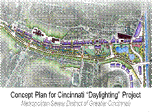
The second urban waters concept is to restore river corridors so that they can better accommodate wet weather flows, improve public access to the waterway, and can serve as an important amenity for the adjoining neighborhoods. A proposed Kinnickinnic River corridor naturalization project in Milwaukee is an example of this. Another example is in Cincinnati, where the sewer district is considering a project to take stormwater out of the combined sewer system (with a major CSO point at the downstream end) and to "daylight" these flows. The project would in effect create a new urban drainage corridor with floodway capacity and riparian park areas and trails. This project potentially would be done in parallel with transportation improvements. This substantial new neighborhood amenity will provide water quality benefits (greatly reduced CSO discharge volumes), accommodate outdoor recreational activities, and be an anchor for socio-economic revitalization. The Region 5 office has supported this project idea with Brownfield site assessments in the project area, and is contributing to planning efforts.
Achievements and Accomplishments
Projects in different communities are proceeding on different schedules, but enthusiasm for these project concepts is high among local partners. Multiple city departments are participating in planning efforts, including water and sewer departments, transportation organizations, and planning and community development departments.
Partners
Key organizations with which EPA's Region 5 office is working include:
- The Milwaukee Metropolitan Sewer District Exit
- The Milwaukee Department of City Development Exit
- The Northeast Ohio Regional Sewer District Exit
- The City of Cleveland Exit
- The Metropolitan Sewer District of Greater Cincinnati Exit
- The City of Cincinnati Exit
- and Hamilton County Exit
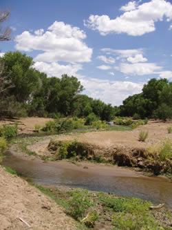
Protecting Drinking Water and Surface Water in the Albuquerque Metropolitan Area, New Mexico
The Greater Albuquerque metropolitan area has a population of over 800,000 and includes 7 communities. The Middle Rio Grande segment, flowing through the urban area is impaired for bacteria. The aquifer serving as drinking water source is high in arsenic and is being depleted. Two tribes, geographically located immediately north and south of the city are also impacted by the Water Quality in the Middle Rio Grande.
Approaches taken to address the issues:
- City is switching to surface water as the primary source of drinking water.
- Enhanced enforcement efforts.
- Aggressive and meaningful bacteria reduction programs from stormwater runoff for Albuquerque and smaller cities.
- Potential post-construction performance standard for e stormwater permits that would take into account the semi-arid climate and water rights issues. Such control would also reduce future increases in flows and pollutants due to development.
- Focus on green infrastructure controls
Project Description
EPA's role is coordination with the state in granting exemption to allow additional time to comply with drinking water standard; Coordination on TMDLS; As the permitting authority in NM, issued stormwater, wastewater and drinking water diversion NPDES permits.
Early this year, the Middle Rio Grande watershed has been also nominated by EPA as a pilot area to explore watershed permitting concepts for stormwater management. The pilot will test mechanisms to better tailor stormwater management plans and stormwater permits to meet the needs and conditions of the watershed. In addition, the pilot will document efficiencies that can be gained by the permitted entities in implementing certain elements of the stormwater program, e.g., education, outreach, and monitoring.
Achievements and Accomplishments
Accomplishments include community driven success to protect urban waters; the city has implemented several storm water quality projects to reduce the amount of trash and debris discharged to the Rio Grande. A study was commissioned by the city to identify potential sources of fecal coliform in selected storm water drainage areas tributary to the Rio Grande in Albuquerque using Antibiotic Resistance Analysis (ARA) methodology.
Many local organizations and community groups are engaged or willing to be engaged in cleaning, restoring, and improving access to urban waters and surrounding waterways. The common mission of the these work groups is to create and implement an overall framework and plan for public education, dialogue and action to measurably improve surface water quality as measured by a reduction of bacteriological pollution in the Middle Rio Grande watershed. There is increased public understanding of watershed approaches and increased participation in water quality improvement activities achieved throughout collaborative water quality management programs.
Partners
- Local municipalities
- Businesses
- Agriculture
- Environmental groups
- State
- Pueblos of Sandia Exit and Isleta Exit
- Other federal Partners and University of New Mexico Exit
- Well-established stakeholder groups toward protection and continuing to revitalize community activities around the Middle Rio Grande Watershed Basin.
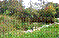
Blue River Watershed/Brush Creek, Kansas City, Kansas/Missouri
Covering 270 square miles, the Blue River comprises the largest watershed in the greater Kansas City metropolitan area. Its drainage is divided between Kansas and Missouri, and flows through three counties, twelve cities, and ten school districts. Brush Creek is the most visible tributary to the Blue River, and the most urbanized and modified stream flowing through the urban core, with many links to Kansas City's urban history. The Blue River Watershed serves as a model watershed for the Urban Waters Initiative for a number of reasons:
-
EPA is actively monitoring water quality and building a monitoring network within the watershed with emphasis on safety, accessibility, and restoration;
 Blue River Watershed
 - Several strong watershed planning partnerships exist in the watershed involving EPA and other federal partners ,universities, planning organizations, watershed alliances, and state and local governments, because urban waters are a priority in Kansas City; and
- The watershed and its main tributary, Brush Creek, flow through a significant degree of urban core lands, where there are active partnerships and on-the-ground projects involving conservation, green-infrastructure, and stream access and education.
Project Description
A tremendous amount of work has already been undertaken by multiple stakeholders and is planned for the Blue River Watershed. These efforts include large scale watershed planning, sustainable and green infrastructure implementation, and many scales of water quality educational endeavors. Three examples that intersect all activities are noted below.
- KC Urban Water Quality Monitoring - Since 2006, staff in EPA's Region 7 office in Kansas City have actively monitored water quality of 13 urban streams and are developing an urban specific protocol. EPA is also building a monitoring and data sharing partnership for metropolitan Kansas City.
- The Middle Blue River Basin Green Solutions Pilot Project / EPA Office of Research and Development Advance Drainage Concept Project - An effort by the EPA to demonstrate the efficacy of implementing integrated, green infrastructure-based solutions to support control of wet-weather flow pollution problems in an urban core neighborhood within a combined sewer system.
- Green Impact Zone - Over the past year the Regional office's Environmental Justice Program (EJ) has worked closely with the activities in the Green Impact Zone of Missouri (GIZMO), a cooperative neighborhood-based effort focusing American Recovery and Reinvestment Act (ARRA) dollars toward comprehensive sustainable neighborhood repair and development using green solutions, and creating green jobs, in 150 inner-city blocks that border Brush Creek.
Achievements and Accomplishments
- Listening session on urban waters included in 2010 Environmental Justice Showcase
- Partnered in 2009 with the University of Missouri - Kansas City to create a water quality data hosting and sharing site
- Broadened monitoring of urban-core streams and lakes in 2010 and added real-time bacteria telemetry monitoring sites throughout the metro.
Partners
South Platte River, Denver, Colorado
Background
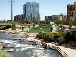
The South Platte River emerges from the foothills of the Rocky Mountains southwest of Denver, where it (along with Plum Creek) fills Chatfield Reservoir, a major flood control and water storage facility for the Denver metro area. The river flows north through central Denver, which was founded along its banks at its confluence with Cherry Creek.
Denver has an estimated population of 610,000 and over 3 million people live in the 10-county Denver Metro area. The City has the 10th largest central business district in the US. The South Platte is an important urban recreation amenity in downtown Denver and is heavily used by families and children from the inner city as well as kayakers, rafters and fishermen. Walkers, runners and bicyclists enjoy the South Platte River Trail, the 20 Denver parks along the river, and suburban parks on the river to the north and south of Denver year round.
The South Platte River valley is highly industrialized through Denver, serving as the route for multiple railroad lines as well as Interstate 25. According to the National Wetlands Inventory, there are only 3.3 acres of wetlands remaining along the Denver reach of the River. The South Platte in Denver is on Colorado's 2010 303(d) List of impaired waterbodies for E. coli, arsenic, and cadmium. In addition, impairments for ammonia and nitrate are being addressed in the implementation of a restoration plan (category 4b listings). Also, numerous tributaries to the South Platte in Denver are 2010 303(d)-listed for selenium and E. coli. Both point and nonpoint sources affect water quality. Urbanization and stormwater management play a major role, with 300 stormwater outfalls entering the river in Denver. There are selenium issues in ground water that feeds the river, various contaminant plumes, and trash issues.
Project Description
EPA has been a stakeholder on the River North and River South Greenway master plan efforts and the River Vision Implementation Plan. EPA is currently sampling for emerging contaminants in conjunction with Denver and the State of Colorado and utilizing the EPA laboratory in Golden, CO. EPA is cooperating with groups on the development of appropriate trash survey methods in conjunction with trash cleanup efforts. EPA continues to actively participate in completion of master planning efforts and reinvigoration of water quality improvements (fishable, swimmable South Platte River). An Urban Waters Challenge grant helped fund the Greenway Foundation's River Ranger program. EPA's Region 8 office in Denver is working with The Trust for Public Land to map green infrastructure in an eight-county region in the Denver Metro area. The study area includes 13 major rivers and streams, will identify environmental justice communities that are underserved by parks, will map and assess riparian protection, and will assess trail connectivity.
Achievements and Accomplishments
River North and River South Greenway master plans and the River Vision Implementation Plan were completed with significant community engagement. A Brownfields assessment was conducted on a former trucking facility that will be a park adjacent to the river. Superfund and Brownfields cleanups are completed and ongoing.
A newly announced Brownfields Area Wide Planning grant will help Denver and its partner, the Greenway Foundation, to plan further cleanups in the River corridor in the next two years.
The Denver South Platte River Commission and the Greenway Foundation have been responsible for significant cleanup, redevelopment, parks, and recreational opportunities along the River. http://www.greenwayfoundation.org/ Exit
Partners
- Greenway Foundation Exit
- Urban Drainage and Flood Control District Exit
- City and County of Denver, Parks and Recreation, Public Works, Community Planning and Development, Finance, City Council Exit
- Denver Water Exit
- Colorado Water Conservation Board Exit
- U.S. Army Corps of Engineers Exit
- Environmental Protection Agency
- Denver Urban Gardens Exit and Feed Denver Exit
- The Trust for Public Land Exit
- Trout Unlimited Exit
- Great Outdoors Colorado Exit
- Denver Parks and Recreation Exit
- Denver Environmental Health Exit
Santa Cruz Watershed, Tucson, Arizona
The Santa Cruz River has its headwaters in Arizona's San Rafael Valley, in the south central part of the state. The river flows south and makes a 25-mile loop through Mexico before returning to the U.S east of Nogales, Arizona. The river then flows north from the U.S.-Mexican border, through Tucson, and up to its confluence with the Gila River, just southwest of Phoenix.
The Santa Cruz Watershed covers approximately 8,000 square miles, representing about 10% of the state of Arizona.
Most of the population in the Santa Cruz Watershed is found in the city of Tucson (population 530,000), the state's second largest city. Over 370,000 people live in the sister cities of Nogales, Sonora, Mexico and Nogales, Arizona. Outside urban areas, grazing and irrigated crop production are the main land uses. Mining is scattered across the watershed. The watershed includes eight designated wilderness areas, along with national forests and national parks.
This watershed is currently impaired for the following pollutants: ammonia, chlorine, chlorophyll, copper, dissolved oxygen, E. coli bacteria, mercury, nitrogen, low pH, phosphorus, and zinc.
Project Description
The objective of this project, Conserving the Santa Cruz River: A Civic-Science Approach, is to conserve and augment watershed functions and local water tables that support the river and riparian corridor through on-the-ground restoration and water harvesting projects. Building directly on information gained from these activities, we will develop a coordinated monitoring plan in the rural and urban areas of the watershed. Monitoring information and lessons learned regarding this watershed approach to restoring and conserving riparian conditions will be made available to local decision-makers to assist in implementing current policies and developing innovative new conservation management strategies. The Conservation Steering Committee will ensure that information gained and progress made from on-the-ground restoration and monitoring activities and innovative policies that are outlined in the State of the Santa Cruz River report will synergistically contribute to long-term, community-driven and collaborative, conservation of the watershed. These activities are critical to retaining the ecological and cultural values of the region and promoting long-lasting conservation.
Achievements and Accomplishments
The City of Tucson, AZ has passed the nation's first Rainwater Harvesting and Gray Water Ordinances. The city estimates that 45 percent of water use is for landscaping. The Rainwater Harvesting Ordinance requires rainwater harvesting plans and capturing systems for any new commercial building built after June 1, 2010. The Gray Water Ordinance requires that new homes be plumbed for gray water irrigation systems. This means having a drain for sinks, showers, bathtubs, and washing machines separate from drains for all other plumbing, to allow for future installation of a gray water system. A key factor contributing to the success of this ordinance was the involvement from the entire community, from plumbers and landscapers to the Friends of the Santa Cruz River, who added their support for the ordinances success. In addition, the Sonoran Institute is facilitating training on retaining rainwater on-site and distributing rainwater catchment barrels to the communities. All of these activates are being funded through an EPA Targeted Watershed Grant to the Sonoran Institute.
Partners
- Arizona Department of Environmental Quality Exit
- Arizona Department of Water Resources Exit
- City of Tucson Exit
- Coordinated Resource Management (CRM) - A consortium of federal and state agencies working with land users to better coordinate resource management.
- Friends of the Santa Cruz River Exit
- Pima County Exit
- Santa Cruz County Exit
- Sonoran Institute Exit
- Tohono O'odham Nation Exit (including the San Xavier District located on the Santa Cruz River)
- Tucson Audubon Society Exit
- US EPA: US-Mexico Border 2012: Arizona-Sonora Workgroup
- US National Parks Service - Tumacacori Exit
- United States Geological Survey Exit
- University of Arizona - NEMO Exit
Learn more about the Santa Cruz Watershed
Columbia River Basin, Washington/Oregon/Idaho
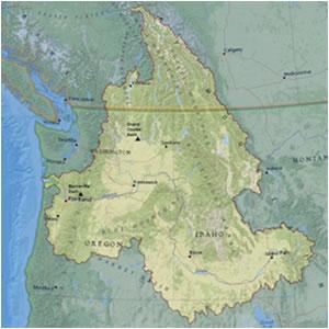
The Columbia River Basin watershed is one of the world’s great river basins in watershed size, river volume, and environmental and cultural significance. It provides drainage for hundreds of rivers, creeks, and streams - covering an area of more than 260,000 square miles and flows over 1,200 miles from its source in the Canadian Rockies to the Pacific Ocean. EPA has designated the Columbia River Basin as a national priority Large Aquatic Ecosystem. The watershed provides an important backdrop for urban development, agriculture, transportation, recreation, fisheries and hydropower in the western United States.
But heavy use has also caused significant declines in the salmon population. The tribal people of the Columbia River have depended on salmon and lamprey for thousands of years for human, spiritual, and cultural sustenance. Columbia River salmon and steelhead runs were once the largest runs in the world, but are now threatened and endangered in large part due to degradation of habitat and water quality from the presence of toxic contaminants.
EPA and other federal agencies, states, tribes, and nonprofit partners established the Columbia River Toxics Reduction Working Group to share information, coordinate activities, and develop strategies to identify and reduce toxics in the Columbia River Basin.
Project Description
After gathering itself from Canada, seven Western states, and two time zones, the Columbia … heaves more water into the Pacific than any other river in North or South America, more than ten times what the Colorado sends through the Grand Canyon, twice the flow of the fabled Nile.
excerpted from Voyage of a Summer Sun by Robin Cody (used by permission of the author)
Indian Creek Watershed Outreach and Community Involvement
Indian Creek, which flows through Nampa, Idaho, is a tributary of the Snake River which meets the Columbia in eastern Washington. EPA has awarded the City of Nampa a Special Project Environmental Justice Grant to develop a public education and outreach campaign focusing on the Hispanic community (the Boise/Nampa/Caldwell area is home to one of the fastest-growing Hispanic populations in Idaho). With funding from the grant and translation assistance, Nampa’s Stormwater Program Team is working to increase the community’s awareness of stormwater impacts on water quality in Indian Creek and other local water bodies.
Partners
- City of Nampa, Idaho Stormwater Division Exit
- Columbia River Inter-Tribal Fish Commission Exit
- Columbia Riverkeeper Exit
- Confederated Tribes of the Umatilla Indian Reservation Exit
- Idaho Department of Agriculture Exit
- Idaho Department of Environmental Quality
- Lower Columbia River Estuary Partnership Exit
- Nez Perce Tribe Exit
- NOAA, Northwest Fisheries Science Center
- Northwest Power and Conservation Council Exit
- Oregon Department of Environmental Quality
- Oregon Office of Env. Public Health
- Oregon Environmental Council Exit
- U.S. Fish and Wildlife Service
- U.S. Geological Services
- Washington Department of Ecology
- Washington Department of Health
- Confederated Tribes and Bands of the Yakama Nation
Learn more about the Columbia River Basin and follow EPA's Columbia River tweets on TwitterExit