Mapping Application Partnership Tool for Anacostia Watershed (Washington, DC/Maryland)
Access the MAPT tool for the Anacostia River Watershed.Exit
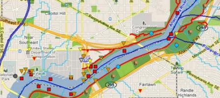
With the help of the USGS, the Anacostia Pilot for the Urban Waters Federal Partnership (UWFP) has developed a mapping application to assist with planning and communication within the UWFP, but also as a tool for agencies to use when needing to communicate and plan within their own agency about the UWFP and eventually to facilitate communication with local jurisdictions and stakeholders. This is the first of many projects that the UWFP is planning.
The MAPT is the first of many projects developed by the UWFP. The development of the tool has been a multi-agency effort. The USGS provided the framework of the viewer and has continued to provide support staff to refine the viewer and add data from federal partners. Thus far many agencies have provided spatial data. The viewer currently contains that following data:
- EPA superfund sites,
- EPA NPDES discharges,
- EPA brownfields,
- EPA Toxic Release Inventory,
- EPA Sewer Overflow Outfalls,
- EPA RCRA Sites,
- USGS wells site,
- FWS contaminates,
- FWS coastal program sites,
- FWS school yard habitat sites,
- NPS project sites,
- surface elevation tables,
- NPS trails,
- DC area trails,
- NPS park land,
- county and regional park land,
- EPA 303(d) impaired waters,
- USGS National Land Cover Database,
- census data,
- DC political boundaries,
- and Anacostia River watersheds, reaches and subwatersheds.
The most recently added data are data points from the Anacostia Restoration Partnership (ARP) that represents:
- the location of 3018 candidate restoration projects,
- their potential pollutant reduction as calculated by the WTM,
- scores of specific project attributes,
- overall project score, tier, clustering,
- and rank of associated cluster.
This file is the master list of projects and project scores as developed during ARP plan formulation.
This tool is currently being used to assist the UWFP in narrowing down areas in which to implement projects. Using the viewer four river reaches have been identified where federal partners have existing or planned programs and can interact with local advocates in the Anacostia River to maximize resources and improve the health of the community.