Advanced Nutrient Monitoring

New technologies are changing the way we monitor pollution levels in the environment. EPA is studying innovative technologies that will measure nutrient pollution in the air and water using satellites, portable and ground remote sensors as well as measurement and model data. These technologies enhance current monitoring activities and also provide cheaper and faster information on nutrients and other pollutants.
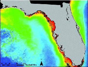
One such study conducted in 2011 focused on Florida’s coastal waters. The purpose of the study was to evaluate the use of satellite measurements as a way to analyze water quality and to help regulators set standards for nutrient pollution.
Nutrient pollution, excess nitrogen and phosphorous carried in runoff and other sources from land sparks excessive algal growth in many water bodies, and could also occur in coastal waters. Researchers used the SeaWiFS satellite to measure the amount of chlorophyll-a, a pigment present in algae, as a way of monitoring nutrient pollution in coastal water.
Researchers compared thirteen year’s worth of data from the SeaWiFS satellite to measurements from field studies to see if the satellite’s readings could be used to measure water quality. The study showed that this unique application of satellite data for monitoring water quality is effective and could be applied to other satellites and other coastal waters. For more information on this study, see the first link below.
Research Article: An Approach to Developing Numeric Water Quality Criteria for Coastal Waters Using the SeaWiFS Satellite Data Record
