ACE: Environments and Contaminants - Contaminated Lands
- Indicators
- Indicator E10 – Percentage of children ages 0 to 17 years living within one mile of Superfund and Corrective Action sites that may not have all human health protective measures in place, 2018
- Indicator E11 - Distribution by race/ethnicity and family income of children living near selected contaminated lands in 2018, compared with the distribution by race/ethnicity and income of children in the general U.S. population
- Background Text
- Methods
Indicators
Indicator E10
![]()
Data characterization
- Data on Superfund and RCRA Corrective Action sites are reported by EPA regional offices and states, and compiled in EPA’s databases of information on contaminated sites.
- Information for each site includes the site name, state in which the site is located, latitude, longitude, estimated acreage, and site status; for some Superfund sites there is boundary information.
- Areas of known or suspected contamination may be less than the total acreage at each site.
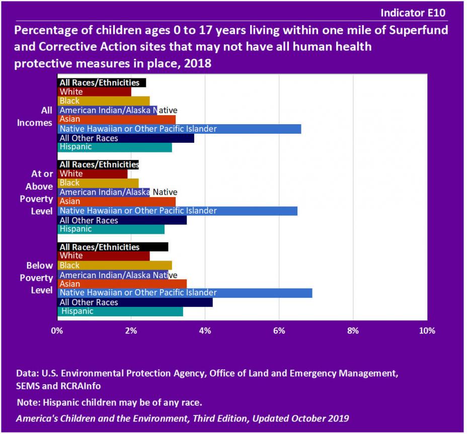
- Approximately 2% of all children in the United States lived within one mile of a Corrective Action or Superfund site that may not have had all human health protective measures in place as of 2018.
- About 3% of Black children, 3% of Asian children, 3% of American Indian/Alaska Native children 4% of children of “All Other Races,” and 7% of Native Hawaiian and Other Pacific Islander (NHOPI) children lived in proximity to the designated sites. About 3% of Hispanic children, who may be of any race, lived in proximity to the sites. In contrast, about 2% of White children lived in proximity to the designated sites.
- About 3% of all children in the United States in families with incomes below the poverty level lived within one mile of the designated sites, compared with about 2% of children above the poverty level. The proportion of children below the poverty level in proximity to the designated sites was greater than the proportion for those above poverty level for each race and ethnicity.
Indicator E11
![]()
Data characterization
- Data on Superfund and RCRA Corrective Action sites are reported by EPA regional offices and states, and compiled in EPA’s databases of information on contaminated sites.
- Information for each site includes the site name, state in which the site is located, latitude, longitude, estimated acreage, and site status; for some Superfund sites there is boundary information.
- Areas of known or suspected contamination may be less than the total acreage at each site.
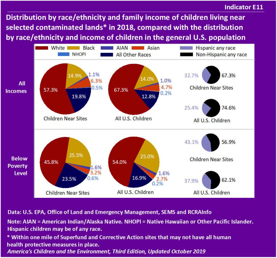
- Approximately 15% of all children living within one mile of a Corrective Action or Superfund site that may not have had all human health protective measures in place were Black, while 14% of children in the United States are Black. Black children account for about 25% of all U.S. children in homes below poverty level as well as among children below poverty level living within one mile of a designated site.
- The percentages of Native Hawaiian and Other Pacific Islander children, Hispanic children, and children of “All Other Races” among children living close to the designated sites were greater than the percentages of these children in the entire U.S. population, considering only those in homes with incomes below poverty level.
Background Text
About the Contaminated Lands Indicators
Indicators E10 and E11 present information about children living in close proximity to contaminated sites that may not have had all human health protective measures in place. The data are from two databases that provide information on these sites and the U.S. Census.
- Indicator E10 presents the percentage of children ages 0 to 17 years living within one mile of Superfund and Corrective Action sites that may not have all human health protective measures in place.
- Indicator E11 presents the distribution by race/ethnicity and family income of children living near selected contaminated lands, compared with the distribution by race/ethnicity and income of children in the general U.S. population.
Accidents, spills, leaks, and improper disposal and handling of hazardous materials and wastes have resulted in tens of thousands of contaminated sites across the United States. The nature of the contaminants and the hazards they present vary greatly from site to site. Contaminated soils are a concern if children are playing, attending school, or residing on or near contaminated lands. In addition, contaminated lands may contribute to pollution of water, air, and foods, creating further potential for exposure to children.
EPA and its partners conduct work on contaminated lands through federally mandated programs such as the Superfund and Corrective Action Programs. The Superfund Program, implemented under the Comprehensive Environmental Response, Compensation, and Liability Act (CERCLA), aims to clean up some of the most hazardous and highly polluted inactive commercial, industrial, and residential properties in the country. The Corrective Action Program, implemented under the Resource Conservation and Recovery Act (RCRA), aims to control and clean up releases at operating hazardous waste treatment, storage, and disposal facilities. EPA is also responsible for other programs that focus on management of contaminated lands, including Brownfields, underground storage tanks, and RCRA waste management and minimization programs.
Indicators E10 and E11 present data on children living in close proximity to contaminated sites that may not have had all human health protective measures in place from the EPA Superfund Enterprise Management System (SEMS) database and the Resource Conservation and Recovery Act Information (RCRAInfo) database.
More information about contaminated lands and Indicators E10 and E11 is provided in the Contaminated Lands section of America's Children and the Environment, Third Edition.
Related Links
U.S. EPA: Basic Information about the Underground Storage Tank Program
U.S. EPA: Brownfields and Land Revitalization
U.S. EPA: Cleanups in My Community
U.S. EPA: Superfund - Basic Information
U.S. EPA: Wastes - Hazardous Waste
Methods
Summary of Methods - Contaminated Lands
EPA's Office of Land and Emergency Management (OLEM) manages the Corrective Action Program and the Superfund Program, and maintains inventories of sites in each program. The Superfund Enterprise Management System (SEMS) database provides information on Superfund sites, and the Resource Conservation and Recovery Act Information (RCRAInfo) database provides information on Corrective Action sites.
Indicator E10 uses the SEMS and RCRAInfo data to present the estimated percentage of children ages 0 to 17 years living within one mile of Superfund or Corrective Action sites that may not have had all human health protective measures in place. Indicator E11 uses the SEMS and RCRAInfo data to present the estimated distribution by race/ethnicity and family income of children living near selected contaminated lands, compared with the distribution by race/ethnicity and income of children in the general U.S. population. To identify land areas in proximity to the selected contaminated lands, a one-mile buffer was drawn around either a circle representing the modeled site area or a site’s boundary when data was available. Data from the 2013-2017 American Community Survey 5-year Estimates on total child population and population by race/ethnicity and family income level were used to estimate the number of children living within the one-mile buffer boundary.
Detailed Methods for Indicators E10 and E11