Quantile Regression: Non-insect Relative Abundance vs. Percent Sands and Fines for Minnesota Streams
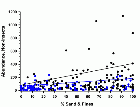
Plot
- Analysis: Quantile regression
- Independent variable: Percentage (%), sand and fines
- Dependent variable: EPT (Ephemeroptera, Plecoptera and Trichoptera) abundance/m²
- Classification variables: Ecoregion class - dummy variable = 0 if the Ecoregions are 46, 47, or 51 and dummy variable = 1 if the Ecoregions are 50 or 52
- Key: symbols = observations, solid line = mean line, dashed line = 95% prediction limit, black lines and symbols = Ecoregions 46, 47 and 51, blue lines and symbols = Ecoregions 50 and 52
- Sample size: n = 267
Model
- Model not plotted due to conflicting resultsa.
- Date: 6 October, 2006
| Variable | Estimate | Chi2 | p |
|---|---|---|---|
| Intercept | 341.6 | ||
| Ecoregion class | -93.0 | 2.74 | 0.098 |
| % Sand & fines | -1.88 | 6.08 | 0.014a |
| % Sand & fines x Ecoregion class | 1.75 | 2.66 | 0.10 |
aHowever, Chi2 had a p > 0.05 (Chi2 = 1.09, p = 0.30) when "ecoregion class" was removed from the quantile regression.
Data Analysis
- Model generated using SAS Proc QUANTREG with the smoothing algorithm. The Wald test statistic was used to test the linear null hypothesis, H0: slope=0, for all independent variables (i.e., ecoregion class, % sand & fines, and ecoregion class x % sand & fines.)
- The ecoregions were aggregated into two classes because a preliminary ANOVA indicated that the base material for bedded sediments, % coarse substrates, was significantly greater in Ecoregions 50 and 52 than in Ecoregions 46, 47, and 51. Percent coarse substrates, however, did not significantly differ within either group.
- Replicate visits to a site were excluded from the data set.
Data Origin
- Agency: Minnesota Pollution Control Agency, St. Paul, Minnesota Exit
- Location: Minnesota - analyses restricted to wadeable sites (52 km² < watershed area < 523 km²) from the five ecoregions indicated below.
- Omernik Level III Ecoregions examined include: 46 (Northern Glaciated Plains), 47 (Western Corn Belt Plains), 50 (Northern Lakes and Forests), 51 (North Central Hardwoods), and 52 (Driftless Area).
Sampling Design
- Data collected 1996 through 2004.
- Sampling protocols: You may need a PDF reader to view some of the files on this page. See EPA’s About PDF page to learn more.
- Description of the sampling methods for invertebrates (PDF)
- Description of the sampling methods for measuring physical habitat characteristics, including % sand and fines (PDF)
- Description of invertebrate enumeration methods
Contact
Michael B. Griffith, griffith.michael@epa.gov, (513) 569-7034