Geographic Information Systems Analysis of the Surface Drinking Water Provided by Intermittent, Ephemeral, and Headwater Streams in the U.S.
This map shows the results of a series of geographic information systems (GIS) analyses examining the extent of different types of streams in the continental United States at the county level. The map was generated as part of an analysis aimed at illuminating regional patterns of dependence on intermittent, ephemeral and headwater streams for water to supply public drinking water systems in the United States, using the most recent, valid data available.
In the continental United States, about 117 million people, over one third of the total U.S. population, get some or all of their drinking water from public drinking water systems that rely at least in part on intermittent, ephemeral, or headwater streams. In the continental U.S., 357,404 total miles of streams provide water for public drinking water systems. Of that total, 58% (207,476 miles) are intermittent, ephemeral, or headwater streams. A more detailed summary of the analysis and breakdown of the results by state and by county are presented.
Click on your state to see the results:
Percentage of Surface Drinking Water from
Intermittent, Ephemeral, and Headwater Streams
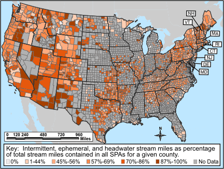 Legend: This map highlights regional patterns of dependence on intermittent, ephemeral, and headwater streams for surface drinking water by county. Across the nation, 357,403 total miles of streams provide water for surface water intakes supplying public drinking water systems; of this, 207,476 miles, or 58%, are intermittent, ephemeral, or headwater streams. Nationwide, over 117 million people receive drinking water from public drinking water systems that rely at least in part on intermittent, ephemeral, or headwater streams. This analysis compared the stream length of intermittent, ephemeral, and headwater streams to total stream length within all mapped Source Protection Areas (SPAs) for each county. A SPA is an area upstream from a drinking water source or intake that contributes surface water flow to the drinking water intake during a 24-hour period. This is based on data that generally do not include streams less than one mile in length. Intermittent streams are streams containing water for only part of the year. Ephemeral streams flow only in response to precipitation events. First-order streams have been used to represent headwater streams. Data Sources: National Hydrography Dataset Plus at medium resolution (NHDPlus provides the geospatial data framework for EPA's WATERS application); Federal Safe Drinking Water Information System 4th Quarter 2006 Data.
- Summary of the analysis including purpose, methods, results, and data sources
- Interactive Drinking Water Map showing the the percent of the U.S. population that gets some of its drinking water directly or indirectly from streams that are intermittent, ephemeral or headwaters
- National Map by Counties
- State Maps
- Study results: data for each state
- Study results: data for each county