Examples of Biological Condition Assessments for Watershed Health
The biological condition of a waterbody is the ultimate indicator of watershed health, as aquatic organisms and communities reflect the cumulative conditions of all other watershed components and processes.
Biological condition is measured in a variety of ways depending on the objectives of the assessment. Multimetric indices, for example, measure the ecological complexity of biological assemblages and usually include representative metrics such as species richness, complexity and tolerance as well as trophic measures. They are intended to represent the biological condition of a waterbody relative to some regionally-defined reference condition.
RIVPACS (River Invertebrate Prediction and Classification System) models quantify biological condition by comparing the observed (O) taxa at a site to expected (E) taxa in the absence of human-caused stress. The O/E ratio is the index of biological integrity and measures loss of native taxa or biodiversity. Biodiversity is also measured by presence of rare, threatened and endangered (RTE) species. State natural heritage programs have inventories of aquatic RTE.
You may need a PDF reader to view some of the files on this page. See EPA's PDF page to learn more. Most of the following links exit the site. Exit
National
EPA’s Bioassessment and Biocriteria Program EPA's Bioassessment and Biocriteria Program lays out the key objectives for developing and implementing bioassessments and biocriteria for use in state and tribal water quality standards programs.
National Aquatic Resource Surveys The EPA’s National Aquatic Resource Surveys are probability-based surveys of the Nation’s rivers, streams, lakes, wetlands and coastal waters reporting on the extent of waters that support healthy ecosystems, recreation and fish consumption. The surveys provide a national picture of aquatic ecosystem health, as well as provide states with the means to evaluate the relationships between stressors, watershed characteristics and the condition of waters to prioritize additional monitoring and management needs.
National Rivers and Streams Assessment (NRSA) U.S. EPA’s NRSA program uses a random sampling design to provide regional and national estimates of the condition of rivers and streams. Physical and chemical water quality, as well as biological integrity are assessed over time to better understand the condition of the nation’s waters. Results of the 2008-09 assessment are summarized in the 2008-2009 National Rivers and Streams Assessment Draft Report and sampling for the 2013-14 assessment is underway.
National Lakes Assessment (NLA) Every five years, EPA, in collaboration with states and tribes, surveys the condition of lakes, ponds and reservoirs across the nation. Its probability-based sampling scheme is intended to collect data that provide a statistically valid representation of lake condition when analyzed on either a regional or national level. Biological data collected include measures of phytoplankton, zooplankton, diatom and benthic macroinvertebrate communities and chlorophyll-a concentrations. Also sampled are chemical constituents to assess relationships with biological measures. Results of the 2007 assessment are summarized in the 2007 National Lakes Assessment Report and analysis of 2012 assessment data is underway.
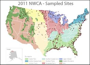 National Wetland Condition Assessment (NWCA) EPA and its State, Tribal, and Federal partners completed the first-ever national survey on the condition of the Nation's wetlands. The survey is designed to provide regional and national estimates of wetland ecological integrity and rank the stressors most commonly associated with poor conditions. The process of designing and conducting the survey is also intended to help build state and tribal capacity to monitor and analyze wetland condition while promoting collaboration across jurisdictional boundaries.
The National Wetland Condition Assessment (NWCA) used a probability-based sampling design to provide statistically-valid estimates of condition for a population of wetlands. States, tribes and federal partners participated in the NWCA design, planning and field assessment. A consistent field assessment procedure was used for the NWCA to ensure that the results can be compared across the country. The NWCA collected data on vegetation, soils, hydrology and algae on the following wetland types: estuarine intertidal emergent, estuarine shrub/forested, palustrine emergent, palustrine scrub/shrub, palustrine forested, palustrine unconsolidated bottom and aquatic bed, and palustrine farmed. Some of the key questions the NWCA should help inform include:
- What is the extent of wetland acreage that supports healthy ecosystems?
- How widespread are the most significant problems affecting wetland quality?
- What is the nature of gains and losses in wetlands acreage?
- What are the characteristics of wetlands soils and what services do they provide on the landscape?
- To what extent do buffers mitigate the effects of stressors on wetland condition?
NatureServe Network Natural Heritage Program Biodiversity Assessments Databases compiling species and community location records from the scientific literature, collections and field inventories are maintained through the state natural heritage programs. State programs use their databases to assess the relative rarity of species and communities as well.
USGS Aquatic GAP Analysis Program The goal of the Aquatic GAP Analysis Program is to keep common species common by identifying those species and communities that are not adequately represented in existing conservation areas or management plans. The Gap Analysis Program (GAP) is sponsored by the Biological Resources Discipline of the U.S. Geological Survey (USGS). This website contains information on the concepts and methodology and provides links to state-specific Aquatic GAP projects. The GAP analysis program has been applied in Ohio, Iowa, Kansas, Michigan and Wisconsin.
Regional
Conservation Priorities for Freshwater Biodiversity in the Upper Mississippi River Basin This study investigated biodiversity within the Mississippi River Basin and identified conservation opportunities to protect key resources and habitat areas.
State
New York State Natural Heritage Program The Department of Environmental Conservation Natural Heritage Program's mission is to "facilitate conservation of New York's biodiversity by providing comprehensive information and scientific expertise on rare species and natural ecosystems to resource managers and other conservation partners." It forms partnerships with various agencies to survey the state's biodiversity and exchange information among decision-makers.
Oregon Biodiversity Information Center Exemplifying the common functions of the state natural heritage programs, the Oregon Biodiversity Information Center supports programs focusing on rare species, invasive species and natural areas in the state.
Virginia’s Interactive Stream Assessment Resource (INSTAR) Several state entities collaborated to produce the GIS-based Interactive Stream Assessment Resource (INSTAR) with the purpose of spatially organizing Virginia’s stream and river biological and physical habitat assessment data. INSTAR allows users to access a comprehensive database representing over 2,000 stream and river collections statewide. Data available for mapping and download include a multimetric stream health index for sampled reaches derived from fish, macroinvertebrate, instream habitat and geomorphic measures. Also available is a watershed integrity index score for each subwatershed in Virginia derived from a multimetric index of biotic integrity.
Pennsylvania Aquatic Community Classification The Aquatic Community Classification (ACC) project involved systematically identifying stream community and habitat types for freshwater mussels, macroinvertebrates and fish. Information from the ACC provides baseline data for preserving instream ecological flow conditions, and allows for the prioritization of high quality aquatic habitats for preservation. Multivariate ordination and cluster analysis were used to classify biological communities. This classification was then refined through an expert review and indicator species analysis.
The classification resulted in 13 mussel communities, 11 fish communities, 12 macroinvertebrate communities at the genus level and 8 macroinvertebrate communities at the family level. Watershed, stream channel, and water chemistry data were then used to describe community habitats, and a model of physical stream types was developed to predict community occurrence based on these channel and watershed attributes.
Watershed and riparian land cover, mines and point sources, stream crossings and dams were used to assess the condition of each stream reach. Least disturbed streams and watersheds were identified and prioritized for watershed conservation actions, and the results are being used in a variety of conservation and watershed management projects in Pennsylvania.