Mariano Lake Mine
The Mariano Lake Mine, also known as the Old Gulf Mine, is located in the Mariano Lake Chapter of the Navajo Nation, approximately 25 miles east of Gallup, NM in McKinley County. EPA is working with the Navajo Nation Environmental Protection Agency (NNEPA) to oversee cleanup work being done by Chevron U.S.A, Inc. (Chevron).
Site Background
Site Facts
- Mariano Lake Mine had a single mine shaft to underground tunnels and a water evaporation pond.
- 505,000 tons of uranium ore was mined between 1977 and 1982.
- Chevron is the company responsible for the mine.
- Primary contaminants polluting the site are uranium, radium and arsenic.
Documents
Mariano Lake Mine was operated from approximately 1977 to 1982 by Gulf Mineral Resources Company, which has since been merged with Chevron. The mine includes two distinct separate areas, the eastern mine area (12.5 acres) and the western mine area (18.5 acres). The main mine shaft was approximately 520 feet in depth and located on the eastern mine area. The western mine area was used as a dewatering pond.
Removal Site Evaluation
The Removal Site Evaluation conducted by Chevron showed that the contamination is primarily inside the two fenced areas. There are several smaller areas of contamination immediately east of the Eastern Mine Area and under the perimeter roads. The affected areas contain approximately 250,000 cubic yards of soil with radium and uranium at levels that could pose a health risk.
Next Steps
EPA will work with NNEPA, Chevron and the community to evaluate potential options to clean up the mine waste. The results will be presented in a report called the Engineering Evaluation/Cost Analysis (EE/CA). Chevron has signed a legal agreement with the EPA to perform this work with oversight from EPA and NNEPA.
Community Involvement
Contacts
Mark Ripperda (ripperda.mark@epa.gov)
(415) 301-1684
Jacob Phipps (phipps.jacob@epa.gov)
(415) 972-3019
Priscilla Tom (tom.priscilla@epa.gov)
(415) 972-3377
Residents of the Mariano Lake Chapter and the surrounding areas have a say in what the EPA is doing in their community. The EPA works with community members and gives them the opportunity to become involved in EPA’s activities to help shape the decisions made that affect their community. The community involvement coordinator from EPA is always available to speak with residents about any concerns they have.
Who is the Community?
Mariano Lake Mine is located within the Mariano Lake Chapter of the Navajo Nation. There are seven residences within one-quarter mile of the site.
EPA Current Community Involvement Activities
EPA works with Mariano Lake chapter officials as well as community members for all outreach activities and information sessions. To keep the community informed, EPA:
- Is developing a Community Involvement Plan
- Meets with people living nearest the mines in their homes
- Distributes fact sheets describing work at the mines
- Attends chapter meetings
- Meets with chapter officials, listen to concerns, and provides updates on site work that may affect the community
EPA Past Community Involvement Activities
EPA completed the following activities in the community:
- Participated in Eastern AUM Region Open House and set up information booths in April 2017
- Conducted in person interviews with community members, chapter officials and other stake holders in June and July of 2016
- Presented updates on site conditions at Chapter meetings in 2013, 2014 and 1015
Partnerships
EPA continues to work and strengthen relationship with a number of organizations focused on uranium and radiation, including:
- Navajo Nation Environmental Protection Agency
- Mariano Lake community
- Navajo Abandoned Mine Land Program
- Mariano Lake Chapter
- Navajo Department of Natural Resources
- Bureau of Indian Affairs
- Navajo Department of the President and Vice President
- Navajo Council
- Navajo Division of Economic Development
Cleanup Progress Timeline
1977-82
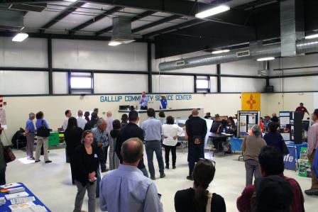
 Mariano Lake Mine Open House at the Gallup Community Service Center | Click to EnlargeMariano Lake Mine was operated from approximately 1977 to 1982 by Gulf Mineral Resources Company (which has since been merged with Chevron).
2012
Chevron completed a removal action and the investigation of the site. They published the investigation results in a report called the Removal Site Evaluation (RSE). Please see the Technical Reports section.
2016
In person interviews with community members, chapter officials and other stake holders in June and July of 2016.
2017
- EPA will oversee Chevron, work with Navajo Nation EPA and the community to evaluate potential options to address Mariano Lake Mine Site.
- EPA and Chevron participated in an Open House in Gallup, NM to inform community members of the cleanup progress.


