Lower Walnut Creek Restoration
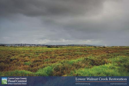
 Pacheco Marsh adjacent to Lower Walnut Creek at the edge of Suisun Bay | Click Image to EnlargeThe Lower Walnut Creek Restoration Project will restore and enhance coastal wetlands along the southern shoreline of Suisun Bay and from Suisun Bay upstream along Walnut Creek, improving habitat quality, diversity, and connectivity along three miles of creek channel, up to 230 acres in total. The project will restore habitat for native and special-status species such as salmonids, salt marsh harvest mouse, Ridgway’s rail, California black rail, and increase food production for native fish. In addition, the restored and enhanced wetlands will provide sustainable flood protection and increased resiliency to sea level rise and storm events.
Project Facts
Recipient: Contra Costa County Flood Control and Water Conservation District
Funding: $1,500,000 (non-federal match = $2,391,869), FFY: 2017
Project Period: September 2017 – September 2021
Partners: John Muir Land Trust, East Bay Regional Parks District, California State Lands Commission, Conco, California Department of Fish and Wildlife, the Walnut Creek Watershed Council, and Flood Control 2.0.
|
OUTPUTS (Activities, efforts, and/or work product during project period) |
OUTCOMES (Environmental results) |
|
|---|---|---|
|
SHORT-TERM |
LONG-TERM |
|
|
Final Construction Drawings and Specifications (entire project) Construct 28 acres of restored brackish intertidal wetland and preserve 2 acres of non-tidal wetland (South Reach) Construct 11 acres of transitional ecotone and upland habitats (South Reach) Construct 3,500 ft of new setback levee Excavate new tidal channels (South Reach) Breach and lower 3,200 ft of levee (South Reach) Interim Vegetation Management (entire project) |
28 acres of restored brackish intertidal, 2 acres of preserved non-tidal wetland, and 11 acres of transitional ecotone and upland habitats, and new tidal channels Contribute to primary productivity and enhance food supply for sensitive pelagic species potentially including Delta smelt and longfin smelt Increase opportunities to wildlife for cover, nesting, foraging and migratory functions. Improve habitat connectivity among wetland, transitional and upland habitats Enhance habitat diversity Provide enhanced high tide refugia for salt marsh harvest mouse and other tidal marsh species 3,500 feet of new levees providing flood protection, continued District access, and a corridor for future construction of a recreational trail along the west side of Walnut Creek (South Reach) |
Up to 110 restored acres of tidal and 19 acres of non-tidal wetlands, 50 acres of adjacent transition and 51 acres of upland habitat restored and enhanced, and new tidal channels Contribute to primary productivity and enhance food supply for sensitive pelagic species potentially including Delta smelt and longfin smelt Increase habitat for sensitive and other native species (salt marsh harvest mouse, Ridgway’s rail, California black rail, steelhead, and Chinook salmon, and potentially spawning habitat for Delta smelt Filter pollutants from terrestrial runoff and improve water quality 1 mile protected linkage between Peyton Marsh and the Point Edith Wildlife Area Reduced invasion of restored site by weeds. Increased cover with target native vegetation and increased habitat diversity |
Full List of Project Summaries
