Reports From Greening America's Communities Projects
Background
The Greening America's Communities Program, formerly known as Greening America's Capitals, helps cities and towns develop an implementable vision of environmentally friendly neighborhoods that incorporate innovative green infrastructure and other sustainable design strategies.
EPA funds a team of designers to produce schematic designs to catalyze or complement a larger planning process for the pilot neighborhood. The design team and EPA, along with partners from other federal agencies, also help city staff develop specific implementation strategies.
Lessons From Greening America's Capitals Projects
The cities that requested assistance through the Greening America's Capitals Program are trying to be greener. They are not alone—communities across the country, large and small, are trying to do the same. This pamphlet describes five lessons from the first two rounds of projects that can help other communities incorporate green design strategies into their planning and development. As these projects demonstrate, environmentally sustainable design can create and enhance distinctive neighborhoods with social, economic, and environmental benefits. Lessons From Greening America's Capitals Projects: Five Helpful Hints for Communities Wanting to Be Greener is available in the EPA Archive. Click on Search EPA Archive and type or copy and paste the title into the search box.

Communities
Reports for these projects, unless otherwise noted, are available by clicking Search EPA Archive and typing "Greening" and the name of the community into the search box on the EPA Archive home page.
Austin, Texas, selected in 2014, received assistance to help visualize great public open spaces, green infrastructure improvements, and safer spaces for people to walk and bike in the South Central Waterfront area. The report illustrates design options to improve pedestrian and bike connections to Lady Bird Lake and incorporate green infrastructure elements to reduce runoff and localized flooding, improve water quality, and increase shade.
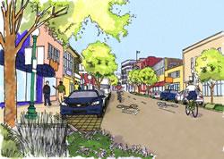
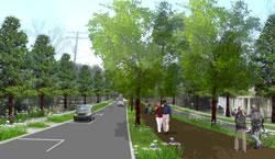 In this design option for Baton Rouge, rain gardens on the side of the street collect and treat stormwater runoff before it goes into the city's sewer system.Baton Rouge, Louisiana, selected in 2012, received assistance to plan a greenway that will connect Louisiana State University with the downtown. The Greening America's Capitals project created design options that incorporate green infrastructure elements into the greenway plan, which provides environmental benefits while sparking new investment and redevelopment in the city's core. The city hopes this project will give residents and visitors options for walking and biking that reduce air pollution from automobile travel and encourage active and healthy lifestyles.
Boston, Massachusetts, selected in 2010, asked for assistance to create greening options for City Hall Plaza, which lies in the heart of downtown, close to the Massachusetts State House and the financial district. Goals for the assistance included creating well-defined edges and entrances, providing more bike access and parking, connecting the plaza to existing streets, increasing green elements such as trees and vegetation for better stormwater management, and supporting energy efficiency and green building improvements in City Hall and nearby buildings.
Brownsville, Texas, selected in 2016, explored adding green infrastructure to the International Greenway along the U.S.-Mexico border to manage stormwater, create a more walkable street, and add shade and plants to cool an area experiencing higher temperatures due to climate change. Report: Greening America's Communities: Brownsville, TX
Carson City, Nevada, selected in 2014, received assistance to improve William Street, which connects the city's downtown with a freeway. The project helped the city explore ways to make William Street more welcoming to pedestrians and bicyclists and enhance the neighborhood's economic vitality. Design options also explored how to incorporate green infrastructure using native plants appropriate for the arid climate.
 The design concept for Charleston's Slack Plaza makes the plaza more pleasant and inviting.Charleston, West Virginia, selected in 2010, requested assistance in redesigning Slack Plaza, which sits in the middle of downtown and hosts the county's major transit hub. The design team worked with the city and stakeholders to establish a common vision for Slack Plaza that could transform it into a multimodal transportation hub and well-used town square. Adding public art and trees and redesigning the pedestrian corridors to serve a range of users will continue Charleston's efforts to foster a more beautiful and sustainable community.
Columbia, South Carolina, selected in 2016, received design assistance to create a greenway along an urban stream to minimize flooding and establish a walkable connection through the Capital City Mill District. The project developed design options for a quiet, natural area along the proposed Rocky Branch Greenway that incorporates green infrastructure, including new street trees and bioswales that can absorb and filter runoff as it percolates into the ground.
Columbus, Ohio, selected in 2014, received assistance to incorporate green infrastructure elements, parks, and open space into the Milo-Grogan neighborhood. The report illustrates design options that use green infrastructure to improve water quality and reduce flooding risks, increase neighborhood park space, and encourage walking and biking within the neighborhood and to adjacent neighborhoods.
 This design option for Des Moines' 6th Avenue provides landscaped areas to absorb and clean stormwater, local art, bus shelters, and other improvements to the street and crosswalks to help make walking and biking safe and enjoyable.Des Moines, Iowa, selected in 2012, received assistance to incorporate green infrastructure elements into a proposed streetscape plan for a one-mile segment of 6th Avenue. The project created design options to revitalize this commercial street, such as wider sidewalks, narrower traffic lanes, better lighting, and improved bus stop shelters, as well as street trees, permeable pavement, and rain gardens to minimize stormwater runoff. The city council adopted the plan in November 2013.
Frankfort, Kentucky, selected in 2012, received assistance to enhance Second Street between the historic downtown and the state capitol. The intersection at Bridge Street and West Second Street is unsafe for pedestrians; the project created design options that could enhance pedestrian and bicycle safety, better manage stormwater runoff, improve connections to the Kentucky River, and attract tourists and visitors to the commercial corridor. Taken together, these improvements would help create a greener, healthier, and safer environment that could revitalize the Second Street corridor.
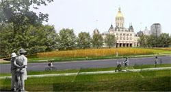 A design option for the landscape at the Capitol Grounds in front of Connecticut's state capitol building in Hartford adds greenery to make the street more pleasant and improve stormwater management.Hartford, Connecticut, selected in 2010, requested assistance to reimagine a mile-long portion of Capitol Avenue, a focal point of the city that includes the Connecticut State Capitol and Legislative Building, the State Library, the Supreme Court, and the State Armory, as well as residential and retail areas. The workshop helped Hartford staff and stakeholders create a redevelopment plan for the Capitol Avenue corridor and connections to nearby locations, such as the Frog Hollow neighborhood and a proposed bus rapid transit station. Redesigns focused on public spaces, such as parks and state building grounds, and green street improvements that better manage stormwater, improve the pedestrian environment and aesthetics, and encourage future redevelopment.
 This design option for Helena's Last Chance Gulch shows a two-way street with on-street parking, pervious paving, shared lanes for bikes and vehicles, and new trees and stormwater planters.Helena, Montana, selected in 2012, received assistance to improve Last Chance Gulch, a street that connects the business district with the historic downtown. Redevelopment in the northern part of Last Chance Gulch has added office, commercial, and residential buildings. As redevelopment continues toward downtown, the Greening America's Capitals project helped the city and stakeholders create a vision that makes the street and intersections friendlier to walking and biking while making sure the neighborhood works for everyone. The project also gave the city options for solving the challenges of a five-point intersection along Last Chance Gulch. Intersection improvements are designed to improve traffic flow, create safer crossings for pedestrians and bicyclists, and improve the connection to downtown.
Honolulu, Hawaii, selected in 2016, received assistance to design street improvements and green infrastructure to better support walking and economic development around two planned rail stations.
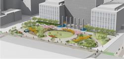 This design option for the City-County Building Plaza in Indianapolis features a central green space for public gathering, kiosks, and rain gardens to collect and treat stormwater runoff.Indianapolis, Indiana, selected in 2012, received assistance to make streets more walkable and revitalize public plazas in and around the Market Square Redevelopment Area. The area is a short walk from the Indiana Statehouse and an emerging multimodal transportation hub connected to the Indianapolis Cultural Trail. The city plans to create a Green Cultural District in the area. The Greening America's Capitals project helped the city create a cohesive vision to ensure that redevelopment benefits the district's underserved residents while expanding economic opportunities and improving the environment.
Jackson, Mississippi, selected in 2011, is exploring retrofitting public spaces within a half-mile of the state capitol building with green technologies such as solar-powered water fountains, native and drought-tolerant landscaping, rain gardens for stormwater treatment, and permeable paving. The area includes the Farish Street Historic District, the city's oldest African-American community, and Congress Street, where the state capitol, city hall, governor's mansion, and other historic sites are located. The project developed design concepts that use green technologies and green infrastructure for Congress Street and two public parks. The city wants Congress Street to be more bike- and pedestrian-friendly to better connect civic buildings with neighborhoods and businesses, and to add street trees to provide more shade for pedestrians.
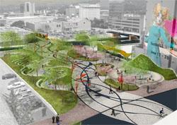
 This design option would restore Wears Creek and transform the Millbottom area near Missouri's state capitol in Jefferson City.Jefferson City, Missouri, selected in 2010, requested assistance with an area of the city core that serves as the gateway to the state capitol and larger Capital Complex. The Wears Creek and Millbottom area had become a flood-prone and forgotten zone of the city with vacant properties and parking lots. Jefferson City worked with the project team to develop design options that could provide both community and water quality benefits, including improving public access to the Missouri River and integrating brownfield cleanup and redevelopment and appropriate reuse of vacant lands. The project emphasized engaging underserved neighborhoods and providing equitable access to urban waters through well-planned community revitalization.
Lansing, Michigan, selected in 2013, received assistance to develop options for transforming a 10-acre parking lot between the state capitol and Hall of Justice into a public park that incorporates green infrastructure to reduce flooding and water pollution and spurs investment in nearby vacant and neglected property. Options for adjacent streets would calm traffic and improve walkability and transportation options for residents, visitors, and workers.
Lincoln, Nebraska, selected in 2011, is revitalizing the South Capitol neighborhood—a primarily residential neighborhood directly south of the capitol—through improvements to the neighborhood's streets and alleys. The neighborhood has deteriorating housing and businesses, wide streets, no bicycle lanes, aging sanitary sewer and water mains, and lower per capita income than the rest of the city. The project involved local residents in developing design options for the neighborhood's streets that improve pedestrian and bicyclist safety and comfort, add more street trees, and incorporate green infrastructure elements such as rain gardens to manage and treat stormwater runoff and make the streets more attractive.
 This design option for Main Street in Little Rock incorporates rain gardens and improved crosswalks to make the street more attractive and better manage stormwater.Little Rock, Arkansas, selected in 2010, requested assistance with investing in economic, environmental, and civic sustainability by revitalizing the Main Street corridor, which connects to the River Market District. The project team developed design concepts for streetscape improvements to help catalyze the redevelopment potential of the Main Street corridor. Focusing on key activity centers along the corridor, the design options highlighted how new pocket parks and reuse of vacant parking lots could encourage redevelopment and more pedestrian activity to support ground-floor retail and a future trolley line.
Madison, Wisconsin, selected in 2013, received assistance to create design options that would make it easier for people of all abilities who live and work in the Triangle neighborhood, a diverse, low-income neighborhood southwest of the downtown, to get around within the neighborhood as well as reach other parts of the city. Design options also explored improving water quality in Lake Monona by using green infrastructure, such as rain gardens and permeable paving, to capture and cleanse stormwater collected from the neighborhood and surrounding streets.
 This design option for the Selma to Montgomery National Historic Trail shows how green infrastructure could delineate the trail as it passes under freeway overpasses. Trellises over the sidewalk could hold banners and lighting to celebrate the trail.Montgomery, Alabama, selected in 2011, asked for assistance to create design options for improvements to the Selma to Montgomery National Historic Trail, where it runs beneath the I-65/I-85 interchange, to reconnect downtown with Montgomery's west side—specifically, the Renaissance Neighborhood, the first green redevelopment project in the city. The design team explored how to increase shade, improve lighting, and reduce freeway noise for trail users. The city also asked for assistance to expand its climate change response planning. The design team looked for opportunities to increase green space to absorb stormwater runoff and help reduce the ambient air temperature.
Montpelier, Vermont, selected in 2013, received assistance to improve pedestrian and bicycle connections to the historic downtown. The city also wanted to reduce the amount of stormwater runoff flowing into the Winooski River, especially since rainfall in the region is expected to increase due to climate change. Design options explored how a missing link of a regional bike trail could be built in the downtown and how two important intersections could be designed to work better for pedestrian, bicyclists, and drivers. Design options also illustrate how more plants and trees could be incorporated into streets and parking lots to make the downtown more attractive and reduce the amount of runoff flowing into the Winooski River.
Multnomah County, Oregon, selected in 2016, received assistance to create designs for streets and public spaces in the Jade District to address heat island and air quality issues, manage stormwater, bolster infill development, and support the character and concerns of the surrounding community.
Muscatine, Iowa, selected in 2016, received assistance to redesign a former state highway that now serves as a city street to help it become a safer gateway into downtown for both cars and bicycles.
Oklahoma City, Oklahoma, selected in 2016, explored using green infrastructure to minimize flooding from a local stream and make improvements to streets in four neighborhoods that will increase safety and improve quality of life for residents.
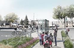
 This design option developed for Olympia shows a shared street with flexible space that pedestrians, bicycles, and vehicles can use. Landscaping defines where vehicles can drive and park, cleans stormwater runoff, and creates pleasant places for people to gather.Olympia, Washington, selected in 2013,received assistance to create a cohesive vision for Capitol Way, the city’s main street downtown that links the state capitol with the popular Olympia Farmers Market. The city hopes that investing in street improvements will spur increased private investment and vitality in the downtown. The design options would make the street more accommodating for pedestrians and bicyclists, add street trees to make the street more attractive and safer, and manage stormwater runoff to improve water quality and minimize localized flooding.
Phoenix, Arizona, selected in 2011, asked for assistance to improve the Lower Grand Avenue streetscape, making it more environmentally, pedestrian-, and bicycle-friendly while also maintaining the neighborhood's artistic character. Lower Grand Avenue is in Phoenix's core and next to downtown and the state capitol. Artists colonized the street, taking advantage of inexpensive vacant and underused warehouse and shop spaces. The area now hosts an annual art festival and monthly First Fridays art events. The design team explored options that use green infrastructure techniques suitable for arid climates to capture and treat stormwater runoff.
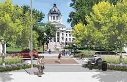 In this design option for Pierre, a midblock pedestrian crossing includes curb bulb-outs with stormwater planters and street trees to collect runoff and draw visitors' attention toward the historic capitol building.Pierre, South Dakota, selected in 2014, received assistance to create a cohesive vision of green and complete streets and public spaces for the city's Governors' Trail, which connects the state capitol building to the Missouri River. The report illustrates design options to create a more pleasant walking experience by adding more shade along the street and incorporating public art.
Richmond, Virginia, selected in 2014, received assistance to improve a segment of Jefferson Avenue, which links the neighborhoods of Church Hill and Union Hill, serving as the gateway to some of Richmond's oldest neighborhoods. The project developed design options for a more pedestrian- and bicycle-friendly street, with more parks and open spaces that incorporate green infrastructure to better manage stormwater runoff.
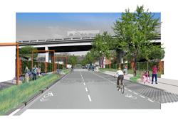
 This design option for Firth Sterling Avenue, which borders the Anacostia Metro station, includes a median for pedestrians that would make it easier for people who cannot cross the street quickly to rest safely at the halfway point.Washington, D.C., selected in 2011, requested design assistance to improve connections between the Anacostia Metrorail station and nearby neighborhoods and schools, the Anacostia business district, and the Anacostia River. This area expects to see significant increases in population and visitors due to several large development projects nearby. Currently, the area has no distinctive character and, although it is next to the Anacostia River, it lacks pedestrian access to the river. The intersections surrounding the station are some of the city's most dangerous for pedestrians. The design team focused on safety concerns at the intersections, improved signage, increasing the overall permeability of the area to manage stormwater, and creating a strong community identity.