Superfund Sites in Reuse in Maine
If you are having trouble viewing the map in your browser, click the 'View larger map' link below
Bangor Gas Works 
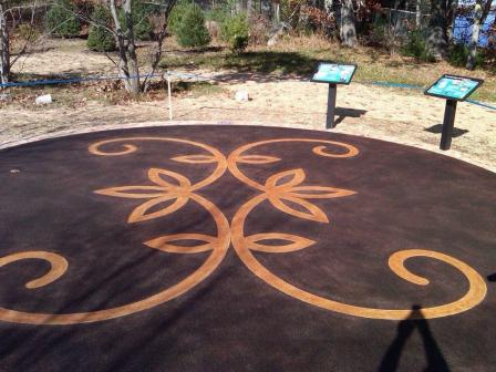
From 1852 to 1963, the 6-acre Bangor Gas Works site operated as a coal gasification plant in Bangor, Maine. The extracted gas provided the city of Bangor (the City) with electricity. Operations stored the remaining thick tar waste in large tanks on site. Tar deposits contaminated site soils and sediments of the nearby Penobscot River. After residents reported fumes from sewer lines and tar sheen on the river surface, the City acquired the site in 1978. The City removed site structures and extracted and removed some contaminated materials from the site. The City also buried and capped some contaminated materials on site. Redevelopment activities paved over the capped area for a parking lot. Today, site uses include commercial space with a 60,000-square foot Shaw’s Supermarket. The site also includes recreational space that connects to the Second Street Community Park next to the site.
Last updated October 2019
As of December 2019, EPA had data on 2 on-site businesses. These businesses employed 135 people and generated an estimated $27,709,000 in annual sales revenue. For additional information click here.
For more information:
Callahan Mining Corp
The 50-acre Callahan Mining Corp. Superfund site is located in Brooksville, Maine. Metal mining operations began at the site in 1880 and ended in 1972. In 1975, the Maine Department of Marine Resources studied marine organisms in the adjacent Goose Pond and found elevated levels of metals. The Maine Department of Environmental Protection conducted additional sampling in 1999. The studies found hazardous substances in site soils and nearby residential properties, site groundwater and on-site waste materials.
EPA placed the site on the National Priorities List (NPL) in 2002. EPA finalized the cleanup plan for part of the site in 2011. From 2010 to 2013, EPA conducted soil cleanup of residential properties and removed contamination from the former Mine Operations Area. Additional cleanup activities include stabilization of the tailings dam and construction of a cover system for the Tailings Impoundment. These activities are expected to begin in 2020. Ongoing design work is focused on the disposal of contaminated materials and sediments in an underwater containment cell, wetlands restoration, institutional controls and monitoring. Cleanup plans for the rest of the site are yet to be determined.
EPA conducted a reuse assessment for the former Callahan Mine property and Goose Pond. The reuse assessment was based on the goals of the site owner, local regulations, community input and reasonably anticipated future land uses. It recommended a habitat conservation area with potential recreation opportunities for the site. Residents currently use the site for various recreation activities, including hiking, rock collecting and ATV riding. Another part of the site is in continued residential use, which includes five seasonal homes.
Last updated October 2019
As of December 2019, EPA did not have economic data related to on-site businesses, or economic data were not applicable due to site use. For additional information click here.
For more information:
Eastern Surplus 
 Eastern SurplusThe 5-acre Eastern Surplus Company Superfund site is located along Meddybemps Lake and Dennys River in Meddybemps, Maine. Eastern Surplus, an army surplus and salvage retailer, operated on site from 1946 until the early 1980s. A facility inspection in 1984 found contamination that threatened local active fisheries and spawning areas.
EPA placed the site on the National Priorities List (NPL) in 1996. To clean up the site, EPA removed contaminated soil and materials and disposed of them off site. EPA also began operating a groundwater treatment system in 2000. Since then, EPA has continued to improve the effectiveness of the groundwater remedy. In 2016, EPA suspended use of the groundwater treatment system and implemented a source control full-scale bioremediation effort. During cleanup, site investigations found Native American artifacts. EPA determined the northern part of the site was eligible for listing on the National Register of Historic Places.
This area, named N’tolonapemk (Our Ancestor’s Place) by the Passamaquoddy Tribe, is now a major archaeological research site. In 2012, parties constructed a commemorative patio and pathway for the area for the public’s use. A seasonal home is located on the southern part of the site. EPA anticipates continued residential, commercial and agricultural use of the southern area.
Last updated October 2019
As of December 2019, EPA did not have economic data related to on-site businesses, or economic data were not applicable due to site use. For additional information click here.
For more information:
Eastland Woolen Mill
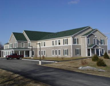 Eastland Woolen MillThe 25-acre Eastland Woolen Mill Superfund site is located in downtown Corinna, Maine. A textile mill operated at the site from 1909 until 1996. Disposal practices contaminated sediments in the East Branch of the Sebasticook River as well as soil and groundwater. In 1999, EPA placed the site on the National Priorities List (NPL). Cleanup activities included removal of hazardous materials, the mill and contaminated soils. Cleanup activities also included installation of a water line and treatment of contaminated soils and groundwater. Groundwater treatment continues today. EPA’s close coordination with the community ensured the productive reuse of the well-located property.
In 2001, EPA’s Superfund Redevelopment Initiative provided a grant to the town of Corinna for a community-based reuse assessment and reuse plan. Based on these plans, a 20-unit senior housing facility opened on part of the site in 2006. EPA, the town of Corinna and the state of Maine also relocated the historic Odd Fellows Building to the site. The building is now home to a country store and restaurant. The site is also home to the town of Corinna War Memorial and a community bandstand. A community boardwalk built in 2008 runs through greenspace along the river. The remainder of the site includes commercial, residential and mixed-use development. In 2012, EPA took 80% of the site’s land area off the NPL after determining cleanup of the areas was complete. This area includes several properties that are currently available for reuse. Site stakeholders hope the area’s deletion from the NPL will further clarify the site’s cleanup status and help support even more reuse.
Last updated October 2019
As of December 2019, EPA had data on one on-site business. This business employed 2 people and generated an estimated $75,000 in annual sales revenue. For additional information click here.
For more information:
- Reuse and the Benefit to Community: A Beneficial Effects Economic Case Study for the Eastland Woolen Mill Superfund Site (PDF)(8 pp, 2 MB, About PDF)
- Redevelopment of the Eastland Woolen Mill Superfund Site (PDF)(2 pp, 1.7 MB)
- Superfund Site Profile Page
Pinette's Salvage Yard
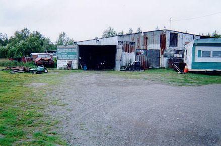 Pinette's Salvage YardThe 12-acre Pinette’s Salvage Yard Superfund site is located about a mile southwest of Washburn, Maine. In 1979, three electrical transformers broke at the site. Fluids containing hazardous chemicals spilled directly onto the ground. The fluids moved through the soil, contaminating groundwater and surface water.
In 1982, EPA placed the site on the National Priorities List (NPL). In 1983, EPA removed some contaminated soil and disposed of it off site. EPA’s cleanup plan addressed contaminated groundwater and remaining contaminated soil. After cleanup, EPA took the site off the NPL in 2002. EPA’s cleanup plan allowed a vehicle repair and salvage yard to continue operating on site. Today, the vehicle repair and salvage yard business remains active. It stores and dismantles damaged vehicles and sells recovered auto parts.
Last updated October 2019
As of December 2019, EPA had data on one on-site business. EPA did not have further economic details related to this business. For additional information click here.
For more information:
Saco Municipal Landfill 
The 90-acre Saco Municipal Landfill Superfund site is located in Saco, Maine. The city of Saco (the City) owned and operated the landfill from 1963 to 1989. The site includes four disposal areas. Chemicals and wastes contaminated soil and groundwater at the site. In 1990, EPA placed the site on the National Priorities List (NPL). Under EPA and Maine Department of Environmental Protection oversight, the City cleaned up the site. Cleanup activities included removing waste and removing and placing contaminated sediment under a cap. Cleanup also includes monitoring of natural processes to clean up groundwater and restricting land use.
In 1998, the City began planning for site reuse. EPA approved a plan to improve wildlife habitat in the former gravel and sand pit in one of the site’s disposal areas. In 2001, the City graded the area, established a vegetative cover, and installed wetland areas next to one of the disposal areas. In 2003, the City completed plans for a community recreation area for hiking, biking, ice skating and soccer. The City constructed two soccer fields for elementary and middle-school children. Reuse planning for additional city facilities is ongoing for unused portions of the site.
Last updated October 2019
As of December 2019, EPA did not have economic data related to on-site businesses, or economic data were not applicable due to site use. For additional information click here.
For more information: