Superfund Sites in Reuse in Missouri
If you are having trouble viewing the map in your browser, click the 'View larger map' link below
77th & Troost Fireworks Explosion
The 77th and Troost Fireworks Explosion site is located in Kansas City, Missouri. A previous resident made and stored fireworks in the basement of the home. In 2000, an open flame or spark ignited the fireworks and the house exploded. One person was killed and several injured in the explosion. EPA completed a removal action at the site in 2000. Cleanup included removal of chemicals and chemical containers. Today, site cleanup is complete and a new home has been constructed on the site.
Last updated September 2019
As of December 2019, EPA did not have economic data related to on-site businesses, or economic data were not applicable due to site use. For additional information click here.
For more information:
- Protecting Public Health Through Time-Sensitive Cleanups: Cleanup, Redevelopment and Continued Used of Removal Action Sites in the Kansas City Metropolitan Area (PDF)(13 pp, 3.1 MB)
- Superfund Site Profile Page
Annapolis Lead Mine 
The Annapolis Lead Mine Superfund site is located in Iron County, Missouri. The 200-acre site includes historic mining areas, Sutton Branch Creek and its floodplain, and the town of Annapolis. Massive piles of mining waste left on site eroded over time, resulting in lead contamination of soils, sediments and nearby bodies of water. EPA added the site to the National Priorities List (NPL) in 2004. EPA worked with the Missouri Department of Natural Resources (MDNR) and the U.S. Fish and Wildlife Service to develop a cleanup plan. The plan addressed contaminated sediments in the Sutton Branch Creek floodplain and contaminated soils in nearby residential yards. Workers excavated and combined contaminated materials, capped them, and planted the area with a mixture of warm and cool season grasses. EPA and MDNR also planted over 1,000 trees, revegetating portions of the site. Cleanup activities also stabilized portions of the creek. In the town of Annapolis, EPA and MDNR tested soils and treated contamination. Studies focused on areas attractive to children, such as residential yards, school yards and church yards. Cleanup construction finished in 2007. MDNR continues to monitor water quality at the site and conducts regular maintenance activities to ensure the remedy remains protective of human health and the environment. A small portion of the Sutton Branch Creek Floodplain is used for hay production.
Last updated September 2019
As of December 2019, EPA did not have economic data related to on-site businesses, or economic data were not applicable due to site use. For additional information click here.
For more information:
Armour Road
The Armour Road Superfund site is a 1.8-acre site located in North Kansas City, Missouri. From the 1920s to 1986, an herbicide mixing and packaging facility operated on site under several different operators. The first facility operator, Reade Manufacturing, leased the property to U.S. Borax, which continued herbicide mixing operations until 1968. Horne and Boatright Company (HABCO) bought and operated the facility until it shut down in 1986. Operations at the facility resulted in arsenic contamination of the soil and groundwater. In 1989, an environmental site assessment for a potential purchaser of the property identified elevated levels of arsenic and other herbicide-related contaminants in the soil and groundwater at the site. In 1996, EPA led a time-critical removal action on site. EPA demolished buildings and covering soil with geofabric and crushed rock to prevent contaminated dust and dirt from moving off site. EPA added the site to the National Priorities List (NPL) in 1999. Conducted by U.S. Borax, cleanup activities included decontaminating and demolishing remaining site buildings, relocating utilities, removing and treating arsenic-contaminated soils, and backfilling the site with clean soil. A medical center and restaurant are now located on site. The site’s new roadway is also a vital link to the nearby One North Redevelopment Area, a high-density, mixed-use hub that will include office space, stores, hospitality centers and residential areas. In September 2019, the site received a Leading Environmentalism and Forwarding Sustainability (L.E.A.F.S.) Award from EPA Region 7.
Last updated July 2020
As of December 2019, EPA had data on one on-site business. EPA did not have further economic details related to this business. For additional information click here.
For more information:
- An Overnight Success Story, Twenty Years in the Making (PDF)(15 pp, 6.8 MB)
- Superfund Site Profile Page
Big River Mine Tailings/St. Joe Minerals Corp. 

The Big River Mine Tailing/St. Joe Minerals Corps. Superfund site is in Desloge, Missouri. The site is part of a former mining region about 70 miles south of St. Louis, often referred to as the "Old Lead Belt." From 1742 to 1972, mining operations resulted in enormous piles of mine waste tailings and chat on site. The site consists of eight large areas of mine waste and spans about 110 square miles. For example, St. Joe Minerals Corporation’s operations disposed of mine tailings across a 600-acre rural area bordered on three sides by the Big River. In 1977, heavy rains caused about 50,000 cubic yards of the Big River Mine Tailings Pile to slump into the Big River, contaminating surface water and soil with heavy metals. Since mining activities ended, the Big River 100-year floodplain is mainly used for agricultural crops and pasture lands. Area residents and businesses used the mine waste as fill for construction projects and as agricultural amendments. Contaminants from the waste seeped into the Big River. After site investigations, EPA added the site to the National Priorities List (NPL) in 1992. The remedy includes mine waste removal and stabilization as well as treatment of dissolved zinc in groundwater seeps. Current land uses for this large site include residential, commercial, industrial, recreational, public services, agricultural and ecological areas. EPA and potentially responsible parties test residential properties for heavy metals. The residential properties also include schools, day cares and parks. EPA replaces contaminated soil as needed. Many commercial and industrial businesses and organizations are located on site. They range from insurance agencies, car dealerships and restaurants to automotive repair shops and a variety of manufacturing operations. People use the Big River for recreation, fishing, canoeing and watering of livestock. The state of Missouri advises people not to eat fish they catch from the Big River downstream of contaminated areas. St. Joe State Park, or the Federal Mine Tailings Site, offers recreational opportunities and ecological resources. Museums highlighting Missouri mining history and mineral resources are located on the sub-site as well. Maturing second-growth forests with native oak and hickory, as well as native grasslands, support native wildlife. People visit the park to hike, camp, ride off-road vehicles and view wildlife. Several city parks, playgrounds, athletic fields and a drag-racing strip offer additional recreation resources. Public service uses in the site area include libraries, emergency service and fire services facilities, law enforcement facilities, postal services, and utility services. The St. Francois County Environmental Corporation operates a transfer station on the St. Joe Tailings Pile. A healthcare facility and a mining museum are also located on former source areas. EPA’s Superfund Redevelopment Initiative supported a regional seed project to develop a reuse assessment at the site. Completed in 2019, the reuse assessment identifies community reuse and redevelopment priorities across four St. Francois County cities – Park Hills, Bonne Terre, Leadwood and Desloge.
Last updated September 2019
As of December 2019, EPA had data on 1,000 on-site businesses. These businesses employed 11,073 people and generated an estimated $1,484,442,806 in annual sales revenue. For additional information click here.
For more information:
- Reuse and the Benefit to Community: Big River Mine Tailings/St. Joe Mineral Corp. Superfund Site (PDF)(429 pp, 12 MB)
- Superfund Site Profile Page
Ellisville Site
The Ellisville Superfund site is in St. Louis County, Missouri. The site includes three separate properties, called operable units (OUs). The 85-acre Rosalie property is OU1. A sewer worked found buried drums on the property in 1980. Site investigations in the 1980s found the buried drums had contaminated soil at OU1. The 11.6-acre Bliss property is OU2. The Bliss Waste Oil Company operated at OU2 during the 1960s and 1970s. The company disposed of wastes on site by dumping and burying drums. The 8-acre Callahan property is OU3. In 1980, investigations found buried drums at OU3. EPA added the site to the National Priorities List (NPL) in 1983. To clean up OU1 and OU3, EPA removed contaminated soils and drums, backfilled with clean soil, and reseeded the area. Cleanup for OU2 included removal of contaminated soil and either incinerating it or transporting it to a permitted landfill. Groundwater investigations are ongoing. A housing subdivision is located on OU1. A developer purchased a small part of OU2 and the adjacent property for future residential use. EPA deleted OU3 from the NPL in 2017.
Last updated September 2019
As of December 2019, EPA did not have economic data related to on-site businesses, or economic data were not applicable due to site use. For additional information click here.
For more information:
Kantex - KCMO
The Kantex-KCMO site is located in Kansas City, Missouri. A circuit-board manufacturing company used to operate on site. The company leased the building to a painting company and stored industrial waste in drums on the rest of the site. Missouri Department of Natural Resources collected samples of drum contents and documented the presence of hazardous waste. Drums were removed and transported to a disposal facility. Today, an electrical-services business operates on site.
Last updated September 2019
As of December 2019, EPA had data on one on-site business. This business employed 3 people and generated an estimated $449,000 in annual sales revenue. For additional information click here.
For more information:
- Protecting Public Health Through Time-Sensitive Cleanups: Cleanup, Redevelopment and Continued Used of Removal Action Sites in the Kansas City Metropolitan Area (PDF)(13 pp, 3.1 MB)
- Superfund Site Profile Page
KCMO Fire Grenades
The KCMO (Kansas City, Missouri) Fire Grenades site is located in Kansas City, Missouri. EPA responded to a residence in August 2005 after the homeowner found five fire grenades in the attic. Fire grenades were fire extinguishers used in the late 1800s and early 1900s. The bottles were made of thin glass designed to shatter when thrown on a fire, dousing the flames. EPA removed the devices and confirmed the contents to be a mixture of high concentrations of tetrachloroethylene and trichloroethylene. The home where the devices were found remains an active residence.
Last updated September 2019
As of December 2019, EPA did not have economic data related to on-site businesses, or economic data were not applicable due to site use. For additional information click here.
For more information:
- Protecting Public Health Through Time-Sensitive Cleanups: Cleanup, Redevelopment and Continued Used of Removal Action Sites in the Kansas City Metropolitan Area (PDF)(13 pp, 3.1 MB)
- Superfund Site Profile Page
Madison County Mines
The 520-square-mile Madison County Mines Superfund site includes all of Madison County and part of the historical “Mine LaMotte Tract” that extends into St. Francois County, Missouri. Mining operations began in the area in the early 1700s and ended in the mid-1900s. Former mine operations left 13 major tailings and chat deposit areas. These are waste materials resulting from mineral processing. Contaminated soil, tailings and chat were used in residential areas for fill, foundation bases, driveway aggregate and top soil. Contaminated materials were also used as aggregate for road construction and as traction on public roadways during winter weather. EPA added the site to the National Priorities List (NPL) in 2003. EPA has subdivided cleanup of the site into seven areas, or operable units (OUs). Cleanup includes removing contaminated soil from residential properties and replacing it with clean soil. EPA’s definition of residential properties includes actual residences as well as public use areas and lands frequented by children, such as day care facilities, parks and greenways. Mine waste locations are being addressed in stages as cleanup plans are finalized. The primary cleanup actions are grading to prevent erosion and installing caps. A Health Education Program and a Voluntary Institutional Controls Program (VICP) have been implemented through cooperative agreements with the Missouri Department of Health and Senior Services. The programs are managed through the Madison County Health Department. These programs raise public awareness of the presence of lead and its effects on human health and the environment. The VICP has been implemented to monitor ground disturbance activities throughout Madison County. The VICP also provides sampling, training and assistance to citizens, public utilities and contractors. The U.S. Forest Service manages part of OU6 as the Silver Mines Recreation Area within the Mark Twain National Forest. The recreation area supports hiking, camping and water access for fishing and kayaking. Residential, public service, recreational, commercial, industrial, ecological, agricultural and federal land uses continue at the site.
Last updated September 2019
As of December 2019, EPA did not have economic data related to on-site businesses, or economic data were not applicable due to site use. For additional information click here.
For more information:
Minker/Stout/Romaine Creek
The Minker/Stout/Romaine Creek Superfund site includes about 10 acres of separate properties near Imperial, Missouri. In the early 1970s, site operators sprayed dioxin-contaminated oil on the Bubbling Springs Ranch horse arena to control dust. This resulted in the death of several horses. Dioxin-contaminated soil removed from the horse arena ended up as fill material in residential areas. These areas included the Minker, Stout, Cashel and Sullins residences. Much of the fill from the Minker residence eroded into Romaine Creek. In 1983, EPA detected dioxin in the soil on site and in Romaine Creek sediments. EPA added the site to the National Priorities List (NPL) in 1983. EPA also permanently relocated 11 families affected by the contamination. Between 1985 and 1989, EPA removed about 28,420 tons of soil at the Minker area, the Sullins and Cashel residences, Romaine Creek and the Stout area. EPA sent the contaminated soil off site for incineration in 1996 and 1997. Contamination in three inaccessible portions of Romaine Creek below the residential area were capped, leaving some waste in-place at depth in the drainage. EPA completed cleanup in 1997. The state temporarily relocated two other families during cleanup of the Minker area; they have since returned to their homes. The site remains in continued residential use.
Last updated September 2019
As of December 2019, EPA did not have economic data related to on-site businesses, or economic data were not applicable due to site use. For additional information click here.
For more information:
Missouri Electric Works
The 6-acre Missouri Electric Works Superfund site is in Cape Girardeau, Missouri. Missouri Electric Works, Inc., sold, serviced and remanufactured electric motors, transformers and equipment controls at the site from 1953 to 1992. During most of this time, the company processed electrical equipment that was filled with oil containing polychlorinated biphenyls (PCBs). Part of the operations were to recover oil from electrical equipment and to recycle or dispose of the oil. These operations resulted in soil and groundwater contaminated with PCBs. During a facility inspection in 1984, the Missouri Department of Natural Resources found soil contaminated with PCBs and over 100 drums containing PCB-contaminated oil. EPA performed additional investigations from 1985 to 1988 and listed the site on the National Priorities List (NPL) in 1990. The site’s responsible parties are cleaning up the site with EPA oversight. Soil on the site property was excavated and thermally treated in 1999 and 2000. Future use of the property is restricted to industrial and commercial uses. Groundwater monitoring is ongoing. An EPA investigation completed in 2018 resulted in no action taken as there was no risk to human health and the environment. In 2010, the site property was purchased and redeveloped. A commercial building and a self-storage facility are located on site.
Last updated September 2019
As of December 2019, EPA had data on 2 on-site businesses. These businesses employed 4 people and generated an estimated $309,000 in annual sales revenue. For additional information click here.
For more information:
Newton County Mine Tailings
The 300-acre Newton County Mine Tailings Superfund site is in Newton County, Missouri. Extensive mining in the area between 1850 and 1970 resulted in underground mine openings with exposed lead, cadmium and zinc ores. Waste from mining activities contaminated surface soil, sediments, surface water and groundwater with heavy metals. EPA added the site to the National Priorities List (NPL) in 2003. Cleanup activities include removal and disposal of contaminated soils and sediments, capping of disposal areas, revegetation of the excavated and capped areas, and monitoring. Institutional controls will restrict the use of the disposal areas. Removal of contaminated residential yard soils and replacement of residential water supplies has finished. A city park has reopened on site. Ongoing remediation of mine waste and contaminated soils have returned over 100 acres to beneficial use, including residential and agricultural uses.
Last updated September 2019
As of December 2019, EPA did not have economic data related to on-site businesses, or economic data were not applicable due to site use. For additional information click here.
For more information:
Newtown County Wells
The Newton County Wells Superfund site is in Joplin, Missouri. From 1972 to 1982, FAG Bearings manufactured ball bearings on site. These operations contaminated soil and groundwater at the site. The contaminated groundwater extends from the facility under the villages of Saginaw and Silver Creek. EPA added the site to the National Priorities List (NPL) in 2000. Cleanup included connecting affected residents to the public water supply, abandoning selected private wells and monitoring groundwater to assess the natural breakdown of site-related contaminants. Groundwater monitoring operations are ongoing and FAG Bearings continues to operate on site. Residences, commercial and industrial businesses located within the area of groundwater contamination also remain in use.
Last updated September 2019
As of December 2019, EPA had data on one on-site business. This business employed 293 people and generated an estimated $5,199,000 in annual sales revenue. For additional information click here.
For more information:
Oak Grove Village Well
The Oak Grove Village Well Superfund site is located in Franklin County, Missouri. The site consists of several areas of trichloroethylene (TCE) contamination in groundwater. TCE is a volatile organic compound. The contaminated groundwater is in the city of Sullivan and Oak Grove Village. The widespread, sporadic nature of the contamination is likely caused by the complex subsurface geology in the area. EPA added the site to the National Priorities List (NPL) in 2002. Residents with private wells contaminated above the maximum contaminant level have been provided with whole house filtration systems. Air mitigation systems were installed within a local commercial show cave to prevent unacceptable exposures to TCE in the air. Land uses above the groundwater contamination consist of residential and commercial areas, including the commercial show cave. These areas remain in continued use.
Last updated September 2019
As of December 2019, EPA did not have economic data related to on-site businesses, or economic data were not applicable due to site use. For additional information click here.
For more information:
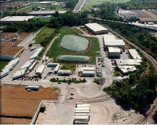
PCB Inc - Missouri
The PCB Inc. – Missouri site is located in Kansas City, Missouri. From 1982 to 1986, PCB Treatment, Inc. operated a business that treated and disposed of materials containing polychlorinated biphenyls (PCBs) at the site. These activities contaminated the walls and floors of the company’s 7-story building on site. EPA took down the building in 2005 and disposed of nearly 20,000 tons of contaminated materials at landfills. EPA also disposed of drums containing chemical wastes. A new mixed-use development is now located at the site. The 12-story building includes luxury apartments and first-floor retail space. The building opened in January 2019.
Last updated September 2019
As of December 2019, EPA had data on one on-site business. This business employed 2 people and generated an estimated $82,000 in annual sales revenue. For additional information click here.
For more information:
- Protecting Public Health Through Time-Sensitive Cleanups: Cleanup, Redevelopment and Continued Used of Removal Action Sites in the Kansas City Metropolitan Area (PDF)(13 pp, 3.1 MB)
- Superfund Site Profile Page
Pools Prairie
The Pools Prairie Superfund site is near Neosho, Missouri. Waste disposal and weed control practices at several military and private industrial facilities in the area contaminated groundwater and soil. EPA added the site to the National Priorities List (NPL) in 1999. The site’s potentially responsible parties (PRPs) are cleaning up contamination. EPA and the Missouri Department of Natural Resources are providing oversight of the cleanup. EPA and the PRPs have identified four source areas that resulted in groundwater contamination impacting nearby private drinking water wells. Residents with private drinking water wells in the area of groundwater contamination were offered connections to the public water supply. EPA and the PRPs have conducted removal activities to address soil contamination at the source areas. Additional soil cleanup, groundwater investigations and groundwater monitoring activities are ongoing. Industrial land uses continue on site, including a tiny house manufacturing business. Recreational, military, federal and public service uses are located above the groundwater plume.
Last updated September 2019
As of December 2019, EPA did not have economic data related to on-site businesses, or economic data were not applicable due to site use. For additional information click here.
For more information:
Prier Brass MFG Co
The Prier Brass MFG Co. site in Kansas City, Missouri, used to house a brass plumbing supply manufacturing facility and warehouse. These activities contaminated soil with metals. The company filed for bankruptcy and stopped operating in 1985. EPA led cleanup activities. Cleanup included treatment of contaminated soil, removal of debris and disposal of chemicals stored on site. A non-hazardous waste management company has operated on the site since 2005.
Last updated September 2019
As of December 2019, EPA had data on one on-site business. This business employed 5 people and generated an estimated $273,000 in annual sales revenue. For additional information click here.
For more information:
- Protecting Public Health Through Time-Sensitive Cleanups: Cleanup, Redevelopment and Continued Used of Removal Action Sites in the Kansas City Metropolitan Area (PDF)(13 pp, 3.1 MB)
- Superfund Site Profile Page
Riverfront
The 325-acre Riverfront Superfund site is in New Haven, Missouri. Site investigations began after the Missouri Department of Natural Resources detected contamination in public supply wells in 1986. EPA identified six areas, or operable units (OUs), where sources contributed to contamination of the site. EPA added the site to the National Priorities List (NPL) in 2000. Cleanup at OUs 1, 3, and 5 includes groundwater monitoring as well as land use and groundwater use restrictions. Sitewide groundwater monitoring continues. Cleanup for OU4 is underway and includes treating soil contamination in place. Cleanup is also underway for OU2 and OU6, the Industrial Drive source area and its resulting groundwater contamination plume, respectively. Cleanup includes treatment of the source area and downgradient plume, installing water treatment units for area homes, and restrictions on land and groundwater use. Several land uses continue at the site during cleanup. These include residential uses, businesses in an industrial park, and a New Haven Public Works property used to store yard waste, compost and gravel.
Last updated September 2019
As of December 2019, EPA had data on 10 on-site businesses. These businesses employed 142 people and generated an estimated $59,627,000 in annual sales revenue. For additional information click here.
For more information:
Shenandoah Stables
The 7-acre Shenandoah Stables Superfund site is located near Moscow Mills, Missouri. In 1971, a St. Louis waste oil hauler sprayed the horse arena with about 2,000 gallons of dioxin-contaminated oil for dust control. Afterward, several adults and children became ill, and many birds, rodents and horses died. In 1971, site operators removed contaminated soil for use as fill material for a new highway. In 1972, site operators disposed of more soil removed from the arena in a swampy area on site. EPA sampling in 1982 confirmed dioxin contamination of the arena soil. EPA added the site to the National Priorities List (NPL) in 1983. EPA started site cleanup in 1990. Cleanup activities included the removal and off-site burning of tons of dioxin-contaminated soils. Following the removal of site contaminants, cleanup of site storage structures and fencing further protected public health and safety. EPA took the site off the NPL in 2001. The site remains in continued use as a horse stable.
Last updated September 2019
As of December 2019, EPA did not have economic data related to on-site businesses, or economic data were not applicable due to site use. For additional information click here.
For more information:
South KC Radium
The South KC (Kansas City) Radium site is located in Kansas City, Missouri. EPA responded to a residence in October 2004 after the homeowner found an abandoned radiological source container under the porch. EPA removed the container and shipped it off for appropriate disposal. Follow-up sampling confirmed there was no residual radium remaining at the residence. The home where the radiological storage container was found remains an active residence.
Last updated September 2019
As of December 2019, EPA did not have economic data related to on-site businesses, or economic data were not applicable due to site use. For additional information click here.
For more information:
St. John Drum
The St. John Drum site is located in Kansas City, Missouri. The city of Kansas City (the City) planned to remove a building on a vacant lot, but found chemicals stored on site. In 2001, EPA removed drums and smaller containers of chemicals from the site. The City then removed the building. In 2006, a local organization, Northeast Arts KC, transformed the vacant lot into a community garden.
Last updated September 2019
As of December 2019, EPA did not have economic data related to on-site businesses, or economic data were not applicable due to site use. For additional information click here.
For more information:
- Protecting Public Health Through Time-Sensitive Cleanups: Cleanup, Redevelopment and Continued Used of Removal Action Sites in the Kansas City Metropolitan Area (PDF)(13 pp, 3.1 MB)
- Superfund Site Profile Page
St. Louis Airport/Hazelwood Interim Storage/Futura Coatings Co.
 St. Louis Airport/Hazelwood Interim Storage/Futura Coatings Co.The St. Louis area Formerly Utilized Sites Remedial Action Program (FUSRAP) site includes many properties in two areas collectively referred to as the St. Louis Downtown site and the North County site. The U.S. Army Corps of Engineers currently manages the cleanup at all areas of the site. EPA conducts oversight of the cleanup. The St. Louis Downtown site includes the Mallinckrodt Chemical Plant and 63 additional vicinity properties. The St. Louis Downtown site is located in an industrial area in north St. Louis City on the western bank of the Mississippi River. From 1942 to 1957, under contracts with the U.S. government, the site was used for processing uranium ore. Byproducts containing radioactive residuals from the uranium processing were sent to property near the St. Louis Airport during this same timeframe. In 1966, some of this byproduct material was moved about half mile northeast to property on Latty Avenue for interim storage. Between 1977 and 1986, the U.S. Department of Energy brought additional contaminated soils to the Latty Avenue properties for interim storage. Residues from these operations contaminated other properties nearby as well as Coldwater Creek. Coldwater Creek flows through northern St. Louis County until it discharges into the Missouri River. The North County site consists of the St. Louis Airport site properties, the Latty Avenue Properties (which include the Hazelwood Interim Storage site and the Future Coatings Company), Coldwater Creek, which extends 15 miles from the St. Louis Airport site to the Missouri River, and over 148 additional vicinity properties located along haul routes and within the 10-year flood plain of Coldwater Creek. EPA added the North County site to the National Priorities List (NPL) in 1989. Cleanup activities included soil removal and disposal. Active commercial and industrial businesses, residential homes, and recreational areas are located on site. These include retail stores as well as metal salvage and steel fabrication facilities, residential properties and parks within the 10-year floodplain of Coldwater Creek, and a section of the St. Louis Riverfront Trail. Portions of the site also continue to support public services uses. These include railroad lines, bridges and part of a floodwall that protects the St. Louis area from Mississippi River floodwaters.
Last updated September 2019
As of December 2019, EPA had data on 93 on-site businesses. These businesses employed 4,616 people and generated an estimated $1,685,568,484 in annual sales revenue. For additional information click here.
For more information:
Studer Container Service
The Studer Container Service site is located in Kansas City, Missouri. EPA responded to the site in 2012 after the property owner discovered 55-gallon drums and containers of waste that had been dumped on his property. The containers held various waste materials that were not properly secured. Some containers had contents that could easily catch fire. EPA removed and properly disposed of the materials. The owner continues to operate a scrap metal recycling facility at the site.
Last updated September 2019
As of December 2019, EPA had data on one on-site business. EPA did not have further economic details related to this business. For additional information click here.
For more information:
- Protecting Public Health Through Time-Sensitive Cleanups: Cleanup, Redevelopment and Continued Used of Removal Action Sites in the Kansas City Metropolitan Area (PDF)(13 pp, 3.1 MB)
- Superfund Site Profile Page
Syntex Facility
The Syntex Facility Superfund site is in an agricultural area in Verona, Missouri. Initial use of the 180-acre area along the Spring River was for agricultural and recreational purposes. Hoffman-Taff began manufacturing chemicals on site in the 1960s. Hoffman-Taff produced 2,4,5-trichlorophenoxy-acetic acid for the U.S. Department of Defense as part of the production of Agent Orange. Hoffman-Taff leased part of the facility to Northeaster Pharmaceutical and Chemical Company (NEPACCO) for the production of hexachlorophene, a chemical antiseptic. Syntex Agribusiness (Syntex) bought the facility in 1969, with NEPACCO continuing to operate until 1972. Dioxin was an intermediate byproduct of chemical production and purification of hexachlorophene. Waste disposal in several areas at the facility contaminated soil and groundwater. Fish downstream in the Spring River also showed signs of contamination. State and federal agencies began investigating the facility for pollution releases in the 1980. EPA added the Syntex facility to the National Priorities List (NPL) in 1983. EPA removed and treated contaminated soil using thermal techniques, and capped and revegetated removal areas. The shallow aquifer in the area is used by rural households for domestic purposes and some agriculture. Water utilities and large-scale agricultural operations use the deep aquifer. A chemical manufacturing facility currently makes nutritional supplements on site.
Last updated September 2019
As of December 2019, EPA had data on one on-site business. This business employed 68 people and generated an estimated $88,851,000 in annual sales revenue. For additional information click here.
For more information:
Times Beach
The 1-square-mile Times Beach Superfund site is located 20 miles southwest of St. Louis, Missouri. The site is a formerly incorporated city that sprayed its roads with waste oil to control dust in the early 1970s. During a 1982 investigation, EPA discovered that the city used dioxin-contaminated oil. During the same period, the nearby Meramec River flooded the city and residents had to evacuate their homes. Afterward, the Centers for Disease Control and Prevention recommended the permanent relocation of the evacuated residents. EPA added the site to the National Priorities List (NPL) in 1983. EPA also transferred funds to the Federal Emergency Management Agency (FEMA) for the permanent relocation of residents and businesses in 1983. All residents successfully relocated by the end of 1986. The state of Missouri then took ownership of the site. Cleanup activities finished in 1997. In 1999, a state park opened at the restored site. EPA took the site off the NPL in 2001. The Route 66 State Park includes a portion of old Route 66, including the historic bridge across the Meramec River. The park provides more than 7 miles of trails for hiking, biking and equestrian use. Visitors can see a range of wildlife, including turkeys, geese, deer and more than 40 species of birds. Other park facilities include picnic areas and a boat ramp that provides access to the Meramec River. In 2012, EPA completed a reassessment of the park to determine, in part, if any residual dioxin contamination remained above the recently revised non-cancer reference dose. The reassessment concluded that current use of the Route 66 State Park does not pose risks to public visitors or park workers.
Last updated September 2019
As of December 2019, EPA had data on one on-site business. This business employed 4 people. For additional information click here.
For more information:
Valley Park TCE
The Valley Park TCE Superfund site is in Valley Park, Missouri. The site consists of two source areas and an area-wide contaminant plume. Wainwright Industries and Valley Technologies operated metal processing facilities at the two source areas. Wainwright Industries stopped operating at the facility in 1979. Several other nonmanufacturing businesses have been housed at the Wainwright property since that time. Valley Technologies continues to operate on site. The site consists of the following four OUs: OU1 - Wainwright Remedial Soil, OU2 - Valley Technologies Soil, OU3 - Wainwright Remedial Groundwater, and OU4 - Valley Technologies Groundwater and Area Wide Plume. OU1 addresses the soil contamination in an area within and next to the property formerly owned by Wainwright Industries. OU2 addresses the soil contamination within and next to the property currently owned by Valley Technologies. OU3 addresses groundwater contamination beneath OU1. OU4 addresses the groundwater contamination beneath OU2 and the portions of the commingled, contaminated groundwater plume not addressed by OU3. OU1 and OU3 make up Wainwright Operable Unit (WOU). The selected remedy for WOU included removal of contaminated vapors from soil, removal and off-site disposal of contaminated surface soil, monitoring, removal and treatment of contaminated groundwater, and institutional controls. The OU2 remedy included removal of shallow contaminated soils and removal of remaining contaminated vapor in soil. The OU4 remedy included removal and treatment of contaminated groundwater and institutional controls. Under EPA and state oversight, a potentially responsible party completed construction of the WOU remedy in 1999. EPA completed construction of the OU2 remedy in 2006. Because the WOU and OU2 remedies did not adequately address all site contamination, investigations for future cleanup are ongoing. A landscaping business currently operates on the WOU property. Valley Technologies continues to operate on the OU2 property. Surrounding areas have remained in residential, commercial, industrial and recreational use during cleanup.
Last updated September 2019
As of December 2019, EPA had data on 5 on-site businesses. These businesses employed 58 people and generated an estimated $7,846,000 in annual sales revenue. For additional information click here.
For more information:
Westlake Landfill
The 200-acre West Lake Landfill Superfund site is in Bridgeton, Missouri. In 1939, the land began being used for rock quarrying and crushing activities. Beginning in the early 1950s, parts of the site property were used for landfilling of municipal solid waste and construction debris. Two areas became radiologically contaminated in 1973 when soils mixed with uranium ore processing residues were used as daily cover in the landfilling operation. The U.S. Nuclear Regulatory Commission investigated the site in the 1970s and found two areas impacted by radiological materials at the site. EPA added the site to the National Priorities List (NPL) in 1990. In 2008, EPA decided on a cleanup plan for the radiological and non-radiological areas of the site, which included installing a landfill cover, restricting future land use and monitoring groundwater. In 2018, EPA amended the cleanup plan for the radiological areas of the site, which now includes partial excavation, off-site disposal, and placement of an engineered cover over the landfill when excavation is complete. The responsible parties are now designing the remedies for both the radiological and non-radiological areas, with oversight by EPA. EPA will select a cleanup plan for the site’s groundwater after the responsible parties finish investigating the groundwater contamination. Parts of the site not previously used as a landfill continue to be used for industrial purposes. These areas include a solid waste transfer station and an asphalt/concrete batch plant. Another area of the site continues to be used for tractor-trailer storage.
Last updated September 2019
As of December 2019, EPA did not have economic data related to on-site businesses, or economic data were not applicable due to site use. For additional information click here.
For more information:
Wheeling Disposal Service Co., Inc., Landfill
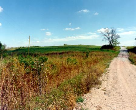 Wheeling Disposal Service Co., Inc., LandfillThe 20-acre Wheeling Disposal Service Co., Inc., Landfill Superfund site is located south of Amazonia, Missouri. Wheeling Disposal Service Company operated a sanitary and industrial landfill on site starting in the early 1970s. The landfill closed in 1986. Former waste disposal activities resulted in site-wide contamination. EPA field investigations detected contamination in monitoring wells, springs and soil on site. In 1989, EPA placed the site on the National Priorities List (NPL). Cleanup included upgrading the existing landfill cap with a clay and soil cover and monitoring groundwater and surface water. Land use restrictions do not allow farming on the capped area. Outside of the capped landfill, about half the site is used for farming. The other half is covered with woodland or native grasses. A private wildlife preserve on site is used for recreational hunting. EPA took the site off the NPL in October 2000.
Last updated September 2019
As of December 2019, EPA did not have economic data related to on-site businesses, or economic data were not applicable due to site use. For additional information click here.
For more information: