Superfund Sites in Reuse in Colorado
If you are having trouble viewing the map in your browser, click the 'View larger map' link below
Asarco, Inc. (Globe Plant)
The ASARCO, Inc. (Globe Plant) site is located in Globeville, an industrial, commercial and residential area near the South Platte River in Denver, Colorado. Various metal and refining operations took place on site between 1886 and 2006. Historical operations contaminated soil, sediment, groundwater and surface water with metals and other chemicals. Cleanup is ongoing. EPA proposed the site for the National Priorities List (NPL) in 1993. EPA removed it from NPL listing consideration in 2014. Site characterization and cleanup took place under a series of agreements between the state of Colorado and ASARCO. Crossroads Commerce Park opened on site in 2016. The business park includes warehousing, distribution and light industrial businesses. The facility provides about 1 million square feet of space. There is also ecological habitat and recreational use associated with the Heron Pond Natural Area located within operable unit (OU) 5. South of Heron Pond is the Colorado National Guard Recruiting center. Commercial and residential areas, schools and parks are located within the OU3 portion of the site where soil remediation has occurred.
Last updated September 2019
As of December 2019, EPA had data on 402 on-site businesses. These businesses employed 4,057 people and generated an estimated $1,087,737,935 in annual sales revenue. For additional information click here.
For more information:
Bonita Peak Mining District
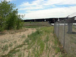
The Bonita Peak Mining District Superfund site is located in San Juan County, Colorado. This large site includes 48 mining-related source areas in a geographic area covering 60 square miles. Hazardous substances consisting of heavy metals from past mining activity negatively affects ecological receptors in three primary drainages at the site: Mineral Creek, Cement Creek and the Upper Animas River. These drainages reach a confluence at the Animas River near the town of Silverton. The Animas River flows south from Silverton toward Durango and is used for drinking water, recreation and agriculture. There are over 400 abandoned or inactive mines at the site. Mining at the site occurred from the 1870s until 1991. EPA and the state of Colorado began investigating the area in the 1990s. The last remaining mining operator at the site, Sunnyside Gold Corporation, intermittently treated mine-impacted water from the Sunnyside Mine, beginning in the late 1980s. Water treated at the Sunnyside Mine was discharged into the Upper Cement Creek portion of the Site. Water treatment ended in 2005 after Sunnyside Gold Corporation transferred its discharge permit and treatment plant to an undercapitalized mining operator, and water quality in the Animas River again began to decline. Between 1991 and 2015, EPA, Sunnyside Gold Corporation, the state of Colorado, and the U.S. Bureau of Land Management all performed or oversaw reclamation and Superfund cleanup activities in the Upper Animas watershed aimed at improving downstream water quality. On August 5, 2015, an EPA team investigating the Gold King Mine as a source of metals inadvertently triggered a release of 3 million gallons of acidic, mine-influenced waters. Since October 2015, EPA has been operating an interim water treatment plant in Gladstone, Colorado, to treat water from the Gold King Mine. EPA added the site to the National Priorities List (NPL) in September 2016. A sitewide remedial investigation is ongoing and EPA is reviewing possible cleanup approaches. Parts of the site are under federal management by the U.S. Bureau of Land Management and the U.S. Forest Service. Tourism, retail and recreation have emerged as key industries in the area, including ongoing, high-volume all-terrain vehicle use on high alpine roads. There is an advanced-terrain ski area north of Silverton.
Last updated September 2019
As of December 2019, EPA did not have economic data related to on-site businesses, or economic data were not applicable due to site use. For additional information click here.
For more information:
Broderick Wood Products
 Broderick Wood ProductsThe 64-acre Broderick Wood Products (BWP) Superfund site is located north of Denver, Colorado, in unincorporated Adams County. BWP operated a wood-treating facility on site from 1947 to 1982. BWP treated power poles, fence posts, railroad ties and other wood products on the property. Operators disposed of hazardous waste from the process in two unlined impoundments on site. In 1984, EPA added the site to the National Priorities List (NPL) due to contaminated groundwater, soil and sludge. Broderick Investment Company (BIC), the potentially responsible party, completed most of the cleanup between 1989 and 1994. In 2003 and 2004, Union Pacific Railroad worked with EPA, the state and BIC on a rail line embankment across the site. The project supported a larger effort to improve rail service and reduce rail congestion in the Denver area. As part of this project, parties made improvements to site cleanup systems. In 2005, BIC constructed an access road at the site’s northern boundary. This road served as the primary access point and helped facilitate redevelopment. In January 2007, BIC sold most of the site property to Scott Contracting. Brannan Sand & Gravel acquired the property in 2013. It operates an asphalt plant on site.
Last updated September 2019
As of December 2019, EPA had data on one on-site business. This business employed 5 people and generated an estimated $6,845,000 in annual sales revenue. For additional information click here.
For more information:
California Gulch 

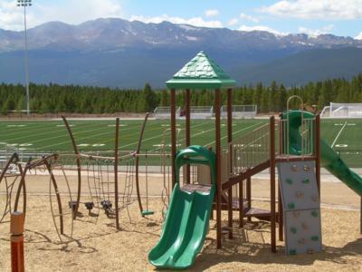 California GulchLocated in Lake County, Colorado, the 18-square-mile California Gulch Superfund site includes the city of Leadville and surrounding area. Beginning in 1857, prospectors and companies mined the area extensively for heavy metals. Mining operations left mining byproducts on site. These materials contain heavy metals that contaminated native soils and waterways, like the Arkansas River. EPA added the site to the National Priorities List (NPL) in 1983. Cleanup actions in over 80 percent of the site, including the city of Leadville, are complete. EPA has removed those areas from the NPL. Over the years, EPA worked with the state, the community and the site’s potentially responsible parties to coordinate the continued residential, commercial and industrial uses of the site, as well as redevelopment and ecological restoration work. Currently, a 250-home mixed use development is underway at the Old Railyard site, also known as Poverty Flats. This development includes commercial and retail space, single-family homes, townhomes and condominiums. The $1.5-million Lake County Community Park and Sports Complex opened on site in 2009. The complex includes a synthetic turf athletic field built on a former zinc smelter. One of EPA’s national partners, the United States Soccer Foundation, awarded a $10,000 grant to develop initial plans for the field. Community support also led to the creation of a 21,000-square-foot concrete skate park that opened in fall 2013. Additionally, a community-driven initiative called the Huck Finn Park Project upgraded an existing Leadville park into a skate board park along with new ice-skating facilities. These include a warming hut, restrooms, concessions and park equipment storage. Moreover, the community also incorporated reuse of mining byproducts into the design of the Mineral Belt Trail, which opened in 2000. This nationally-recognized recreation trail is built around the city along a railroad grade, which weaves through the historic mining district highlighting the community’s history and heritage. Recreational reuse at the site also includes the Arkansas River Trail, a 5-mile loop along the Upper Arkansas River. Leadville’s extensive recreational opportunities and 10,000-foot elevation attract endurance athletes for a variety of events. In 1998, EPA and the state signed agreements to provide public access to open space near the Arkansas River. State and local governments bought more than 2,300 acres of ranch land that serve as wildlife habitat and recreational resources. After decades of cleanup that benefited the ecology of the watershed, Colorado Parks and Wildlife honored the site with a Gold Medal Waters designation in 2014. The designation notes the accomplishment of the Upper Arkansas River’s improved water quality and revitalized habitat for trout and other wildlife. Also in 2014, EPA Region 8 celebrated the project with its Excellence in Site Reuse Award, recognizing several parties for their leadership and sustained involvement with key reuse projects at the site.
Last updated September 2019
As of December 2019, EPA had data on 196 on-site businesses. These businesses employed 1,318 people and generated an estimated $116,687,346 in annual sales revenue. For additional information click here.
For more information:
- Recreational and Ecological Use at Superfund Sites Story MapEXIT
- Recreation and Tourism Reuse and the Benefit to Community: California Gulch Superfund Site (PDF) (13 pp, 1.1 MB, About PDF)
- Superfund Site Profile Page
- Video: Making a Difference in Communities: California Gulch Superfund Site, Leadville, Colorado
- Video: California Gulch: From Metals to Medals
- Video: California Gulch: Revitalizing the Future of a Mining Mega Site
Captain Jack Mill
The Captain Jack Mill Superfund site is located about 1.5 miles south of Ward, in Boulder County, Colorado. The site is in the headwaters of upper Left Hand Creek in a narrow valley called California Gulch. Mining for gold and silver in the region began in 1860 and ended in 1992. Historic mining operations contaminated soil and surface water. EPA added the site to the National Priorities List (NPL) in 2003. Cleanup of surface contamination included consolidating and capping waste. EPA completed this work in 2012. Cleanup of contamination below ground is ongoing. This work includes containing and treating contaminated water in the mine tunnel system. There is also a residence on the site and several nearby. The majority of the land is privately held.
Last updated September 2019
As of December 2019, EPA did not have economic data related to on-site businesses, or economic data were not applicable due to site use. For additional information click here.
For more information:
Central City, Clear Creek
The 400-square-mile Central City, Clear Creek Superfund site includes the former mining towns of Central City and Black Hawk, Colorado. For almost a century, vast deposits of gold and silver ores in the area supported a profitable mining industry. In the early 1900s, business in Central City and Black Hawk dramatically declined. This decline left the towns with a weakened economy and deteriorating infrastructure. The mining industry also left behind waste rock and mine tailings that contaminated the Clear Creek watershed. EPA added the site to the National Priorities List (NPL) in 1983. In partnership with the state, EPA conducted cleanup in stages. After Colorado amended its laws to allow gaming in the former mining towns, parties worked with casino developers to clean up areas of the two towns to support casinos, hotels and restaurants. As parties developed the former mining property, they conducted cleanup actions. In 2009, EPA made additional cleanup funding available. These resources supported the capping of additional mine waste piles, putting sediment and drainage controls in place, and treating water to restore Clear Creek. Cleanup goals include protection of the Clear Creek watershed. The watershed provides water for agriculture and local drinking water supply, as well as a wide range of recreational opportunities, including rafting, kayaking and fishing. Today, limited mining continues in some areas of the site. The Central City Business Improvement District constructed the Central City Parkway to facilitate access to city businesses and homes. The historic Argo gold mill on site hosts tours and serves as a tourism attraction. Argo mill owners are currently exploring redevelopment opportunities for the mill, which is currently in the concept phase. Site cleanup is ongoing.
Last updated September 2019
As of December 2019, EPA had data on 2 on-site businesses. These businesses employed 4 people and generated an estimated $141,000 in annual sales revenue. For additional information click here.
For more information:
Chemical Sales Co. 
The 5-square-mile Chemical Sales Co. (CSC) Superfund site is in Denver, Colorado. Residential, commercial, industrial and municipal land uses are located on site. CSC, a wholesale distributor of commercial and industrial chemicals, detergents and water leisure products, occupied a warehouse on site in 1976. CSC activities led to the contamination of soil and area groundwater. In 1989, EPA removed leaking and corroded drums from the property. Acting on behalf of EPA, the state began additional cleanup actions in 1989. EPA added the site to the National Priorities List (NPL) in 1990. Between 1986 and 1995, the public water district connected over 400 residences to the municipal water supply. Following cleanup, operation and maintenance activities are ongoing. Groundwater and land use restrictions are in place at the site. In 1995, ACME Metals was owned by G.L. Bryan Investments, who purchased the property from CSC in a March 1995 prospective purchaser agreement. In 2009, G.L. Bryan Investments sold the property to Monaco I. ACME Metals continues to operate on the site.
Last updated September 2019
As of December 2019, EPA had data on 62 on-site businesses. These businesses employed 996 people and generated an estimated $390,976,757 in annual sales revenue. For additional information click here.
For more information:
Denver Radium Site 
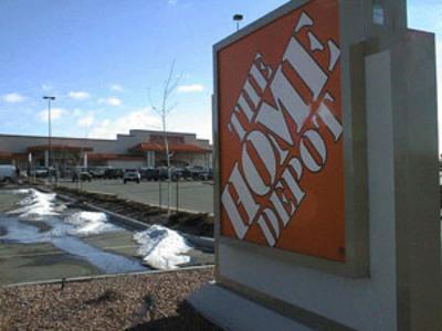 Denver Radium SiteThe Denver Radium Superfund site, located in Denver, Colorado, consists of over 65 properties along the South Platte River Valley. In the early 1900s, Denver ore-processing facilities provided a domestic source of radium for nearby businesses. After the radium industry’s collapse in the 1920s, radioactive substances remained in locations across the Denver area. Parties often used these substances as fill or for paving materials. EPA listed the site on the National Priorities List (NPL) in 1983. Most site properties now support commercial or industrial uses. There are also public service uses, a few residential properties and open space on site. EPA and the state of Colorado designed a flexible cleanup plan that would protect human health and the environment while allowing for future redevelopment. Redevelopment has taken place at several cleaned-up properties. Home Depot USA, Inc. (Home Depot) located one of their retail stores on the site. Cleanup work at the Home Depot location included covering contaminated soils with a protective soil cap designed for the store's parking lot. EPA developed a prospective purchaser agreement (PPA) and a Covenant Not to Sue to address Home Depot's concerns regarding the company’s potential responsibility for site contamination. The requirements of the PPA ensured the site’s soil cap maintenance over time. In 2001, EPA’s Superfund Redevelopment Initiative supported a regional seed pilot at the site. The city of Denver used pilot funds to develop a range of future land use options for the Shattuck Chemical part of the site. Other reuses at the site include Ruby Hill Park, which provides a community swimming pool and other recreation resources, and Encore Evans Station, a 224-apartment complex.
Last updated September 2019
As of December 2019, EPA had data on 76 on-site businesses. These businesses employed 1,250 people and generated an estimated $356,386,286 in annual sales revenue. For additional information click here.
For more information:
- Reuse and the Benefit to Community: A Beneficial Effects Economic Case Study for the Denver Radium Superfund Site (PDF)(21 pp, 4. 3MB)
- Superfund Site Profile Page
Eagle Mine
The Eagle Mine Superfund site is located in Eagle County, Colorado, about 1 mile from Minturn and 75 miles west of Denver. Beginning in the 1880s, a 110-acre gold and silver mine operated on site. In 1938, Eagle Mine transitioned to support zinc mining, which left high levels of metals in the soil, surface water and groundwater. Zinc mining operations ended in 1977. Copper and silver mining and production continued at Eagle Mine until its closure in 1984. EPA added the site to the National Priorities List (NPL) in 1986. Cleanup included the removal of contaminated soils and sediments; containment of mine seepage and runoff; monitoring of surface water, groundwater, pool water and stream water; and land use controls. The potentially responsible party conducted most cleanup actions between 1989 and 2001. After cleanup, community members began using the adjacent Eagle River again as a recreation resource. In 2004, a developer purchased 750 acres of site property for construction of a residential golf course community. In 2009, a new developer with smaller-scale plans took over the project. EPA and the state are currently working with the developer to make sure that all necessary investigation and cleanup steps occur to prepare the property for residential redevelopment. Groundwater treatment and monitoring are ongoing. With EPA’s mission to protect human health and the environment in mind, EPA established the Superfund Task Force in May 2017 to provide recommendations for improving and expediting site cleanups and promoting redevelopment. Based on the Superfund Task Force recommendations, EPA identified the site as a Redevelopment Opportunity site – a site with the greatest expected redevelopment potential.
Last updated September 2019
As of December 2019, EPA did not have economic data related to on-site businesses, or economic data were not applicable due to site use. For additional information click here.
French Gulch
The French Gulch Superfund site is located along French Creek near Breckenridge, Colorado, about two miles upstream of where French Creek meets with the Blue River. Extensive surface and underground mining took place in the French Gulch valley from the 1850s to the 1970s. The site includes mine wastes and the flooded mine pool associated with the former Wellington-Oro Mine. EPA investigations in the 1980s found that the Wellington-Oro Mine was a major source of contamination in French Creek and Blue River. The U.S. Bureau of Reclamation identified several areas of contamination releases in the late 1980s and early 1990s. Under an agreement with EPA, B&B Mines consolidated and capped mining wastes and installed drainage ditches to reduce contamination getting into waterways. B&B Mines completed this work in 1999. The town of Breckenridge and Summit County bought 1,800 acres of land from B&B Mines in 2001. This purchase included the Wellington-Oro Mine. Under a 2005 consent decree with EPA, Breckenridge and Summit County built a water treatment plant for the Wellington-Oro Mine. The plant began operation in November 2008 and groundwater treatment continues. The part of the site acquired by Breckenridge and Summit County is now part of the Golden Horseshoe recreational and open space area. EPA, the state of Colorado, Brynn Grey V, LLC, and Wellington Neighborhood, LLC signed a prospective purchaser agreement in 1999 for an 85-acre property next to the mine, which was developed into a residential neighborhood. The agreement limits Wellington Neighborhood, LLC’s liability for existing contamination. The agreement also lays out requirements for the group to complete restoration of the Union Mill and the Neighborhood Fill and Cover Areas, and to ensure proper cover of impacted soils in the future.
Last updated September 2019
As of December 2019, EPA did not have economic data related to on-site businesses, or economic data were not applicable due to site use. For additional information click here.
For more information:
Lowry Landfill 
 Lowry LandfillThe 507-acre Lowry Landfill Superfund site is in Aurora, Colorado. In 1964, the former owner of the land deeded the site to the city and county of Denver. The localities operated a municipal landfill on site from the mid-1960s until 1984. The landfill accepted industrial and municipal wastes. After 1984, the site continued to accept municipal solid waste until 1990. Storage practices on site resulted in potentially harmful gas releases, contaminated groundwater and soils. As a result, EPA added the site to the National Priorities List (NPL) in 1984. EPA’s cleanup included a groundwater barrier wall, a groundwater treatment plant, a landfill cover and a landfill gas collection system. The groundwater treatment plant uses green remediation practices. After EPA completed construction of cleanup components, the city of Denver, Waste Management and local utility Xcel Energy partnered to reuse the site’s landfill gas. In 2008, a landfill gas-to-energy plant began operating at the site. The plant uses landfill gas from Lowry Landfill and the adjoining Denver Arapahoe Disposal site, which is an active landfill. The plant uses four combustion engines to convert methane gas from both landfill sites into 3.2 megawatts of electrical power annually. This process reduces greenhouse gases and provides electricity for about 3,000 households. The plant also removes about 5,000 tons of methane from the landfill annually. This is the equivalent of removing 22,000 cars from the road each year.
Last updated September 2019
As of December 2019, EPA had data on 2 on-site businesses. These businesses employed 37 people and generated an estimated $8,718,000 in annual sales revenue. For additional information click here.
For more information:
- Superfund Site Profile Page
- Video: Turning Pollution into Electricity
Nelson Tunnel/Commodore Waste Rock
The Nelson Tunnel/Commodore Waste Rock Pile Superfund site is about 1 mile north of Creede, Colorado. The Site was mined from the 1890s until 1976 to produce silver, gold and other metals. The Nelson Tunnel discharges acid mine drainage directly into West Willow Creek. The tunnel and waste rock pile are contaminating West Willow Creek with metals. West Willow Creek joins East Willow Creek to form Willow Creek, which is a tributary of the Rio Grande River, a state-designated Gold Medal fishery. EPA added the Site to the National Priorities List (NPL) in 2008. In 2008 and 2009, EPA conducted a removal action to stabilize the Commodore Waste Rock Pile. In 2011, EPA completed the site’s remedial investigation, which assessed the nature and extent of contamination. EPA is currently conducting the site’s feasibility study to explore appropriate cleanup options. EPA’s Superfund Redevelopment Initiative (SRI) and Region 8 are providing regional seed funding for a reuse situation assessment to determine whether future use of the site can leverage local tourism to support local economic development. Recreational activities occur in a portion of the site where the Bachelor Loop Historic Tour, a 17-mile driving tour, allows tourists to learn about the historic mining district above Creede. The tour crosses portions of Operable Unit 2, which is the Nelson Tunnel portion of the site.
Last updated September 2019
As of December 2019, EPA did not have economic data related to on-site businesses, or economic data were not applicable due to site use. For additional information click here.
For more information:
Pennsylvania Mine
The Pennsylvania Mine site is in Summit County, Colorado. The mine operations began in 1879. It produced gold, silver, lead, copper and zinc. The mine continued regular operations until 1908. Mining then continued intermittently until the mid-1940s, when the mine was abandoned. Acid mine drainage from the site carried contamination into Peru Creek, a tributary of the Snake River. Mining waste and tailing deposits on the surface at the mine site are often washed into surface water during large runoff events. Cleanup activities included capping mine waste to prevent erosion and containing acid mine drainage. Due to the short construction season at high altitude, cleanup work was done in phases over several years. Optional additional phases included treatment of acid mine drainage contained on the site, wetland restoration and creation of a new wetland. The site includes public lands managed by the U.S. Forest Service and is part of the White River National Forest. The area is a popular year-round recreation destination for camping, hiking, biking, running, cross-country skiing and back-country skiing.
Last updated September 2019
As of December 2019, EPA did not have economic data related to on-site businesses, or economic data were not applicable due to site use. For additional information click here.
For more information:
Sand Creek Industrial
The 550-acre Sand Creek Industrial Superfund site is in Denver and Commerce City, Colorado. An oil refinery, a pesticide manufacturing facility, an herbicide chemical plant and a landfill contributed to contamination of soil and groundwater. EPA placed the site on the National Priorities List (NPL) in 1983. Cleanup included removal of buildings, rail cars and tanks, removal and treatment of contaminated soil, landfill capping, and gas collection and treatment. After cleanup, EPA took the site off the NPL in 1996. Operation and maintenance activities at the site are ongoing. Groundwater and land use restrictions are in place at the site. The site is zoned for light and heavy industrial land uses. Commercial and industrial facilities continue to operate at the site.
Last updated September 2019
As of December 2019, EPA had data on 87 on-site businesses. These businesses employed 1,989 people and generated an estimated $603,756,679 in annual sales revenue. For additional information click here.
For more information:
Smeltertown Site
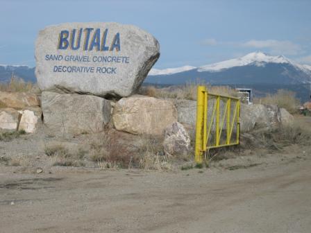 Smeltertown SiteThe 120-acre Smeltertown Superfund site is located near Salida in Chaffee County, Colorado. Many industrial businesses operated on the site over the past century, including lead-zinc smelting and wood-treating businesses. Facility operations contaminated soil, groundwater and surface water. After timber operations ended in 1965, the Butala Construction Company began using the area for sand and gravel mining. EPA began investigating the site in 1986. EPA selected cleanup plans for the site in 1996 and 1998. The companies responsible for the contamination removed and placed contaminated materials in an on-site capped repository, which was then fenced. Monitoring of groundwater and surface water of the adjacent Arkansas River are ongoing. Institutional controls restrict land and groundwater use. Today, the Butala Construction Company continues to operate a sand and gravel quarry on site. The National Park Service listed the former smelter’s 365-foot smokestack on the National Register of Historic Places in 1976. In 2015, a highway marker was created to relay the smokestack’s status and historical importance.
Last updated September 2019
As of December 2019, EPA had data on one on-site business. This business employed 18 people and generated an estimated $3,300,000 in annual sales revenue. For additional information click here.
For more information:
Smuggler Mountain
The 110-acre Smuggler Mountain Superfund site is located in Aspen, Colorado. Between 1879 and 1920, silver and lead mines operated on site. Mining and smelting activities created byproducts and waste materials containing metals and lead. Piles of exposed waste materials eventually spread and mixed with area soils. In the 1980s, soil analyses identified high levels of lead and cadmium. To address area-wide contamination, EPA added the site to the National Priorities List (NPL) in 1986. Cleanup focused on the original mine site, Smuggler Mine, and the northeastern edge of Aspen. Pitkin County and New Smuggler Mine Corporation led cleanup actions. Activities included covering and revegetating areas of mine waste. The parties also secured former mine areas to prevent further contamination and tested residents’ blood-lead levels. After cleanup, EPA took the site off the NPL in September 1999. A 116-acre residential area now occupies a major portion of the site. The residential area includes condominiums, mobile home communities, a tennis club and single-family homes. A local company reopened the mine to extract silver and as a tourist attraction for Colorado travelers. Visitors can tour the mine site and its public use helps bring new income and investments to the community. In addition, several businesses operate on site.
Last updated September 2019
As of December 2019, EPA had data on 33 on-site businesses. These businesses employed 61 people and generated an estimated $5,123,319 in annual sales revenue. For additional information click here.
For more information:
Standard Mine
The 10-acre Standard Mine Superfund site is located in the Ruby Mining District of Gunnison Nation Forest in Gunnison County, Colorado. Silver mining began in the southern Ruby Mining District in 1874 and continued at several mine sites in the area until 1974. Standard Mine was one of the three largest producing silver mines in the Ruby Mining District. Mining activities at the site contaminated soil, surface water and groundwater with heavy metals. EPA added the site to the National Priorities List (NPL) in 2005. EPA selected the cleanup plan for the site in 2011. The cleanup has two phases. EPA completed the first phase in 2017 by conducting source control and setting up a monitoring program to assess the effectiveness of source controls. Monitoring results will determine whether the second phase of cleanup, a passive water treatment system, is needed. Part of the site is owned and operated by the U.S. Forest Service. Therefore, EPA and the state are coordinating with the Forest Service on all cleanup activities. The site is currently used for recreational purposes such as hiking, biking, and camping in the summer, and skiing and snowmobiling in the winter.
Last updated September 2019
As of December 2019, EPA did not have economic data related to on-site businesses, or economic data were not applicable due to site use. For additional information click here.
For more information:
Summitville Mine 
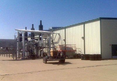
The 1,400-acre Summitville Mine Superfund site is a former gold mine in Rio Grande County, Colorado. The site sits at an elevation of 11,000 feet near the timberline in the San Juan Range of the Colorado Rockies. The area was a gold mine beginning in the late 1800s. By 1984, Summitville Consolidated Mining Corporation began open-pit mining for gold, copper and silver. Mining processes contaminated the surrounding area, including Wightman Fork Creek and Terrace Reservoir. Mining operations did not stop until the company announced its pending bankruptcy and informed the state of Colorado (the State) that financial support for site operations would not continue beyond December 15, 1992. On December 16, 1992, EPA Region 8 assumed control and immediately began emergency removals to address the open pit mine, contaminated soil and sediment. EPA placed the site on the National Priorities List (NPL) in 1994. Today, EPA and the State have reclaimed and revegetated the former mine lands to prevent further contamination of surrounding creeks and streams. A treatment plant removes high metals concentrations from acid mine drainage originating at the site. The treatment plant significantly contributes to improving water quality and restoring fish and aquatic life in the Alamosa River and Terrace Reservoir. The treatment plant uses a significant amount of electricity; EPA and the State have been looking to reduce this expense and footprint. While solar is not practical at high elevations, the community solar garden concept intrigued the site team. Parties subscribe to portions of a large solar project and have their utility bills credited as if the panels were located on their roof. An initial 10-kilowatt subscription was entered into for a community solar garden in Antonito, a town 40 miles to the south at a much lower elevation. This has worked out so well that the State, the lead agency for the site’s long-term operation and maintenance activities, recently entered into a significantly larger subscription with a new solar array. Construction of the array is underway. When operational, the share of the array dedicated to Summitville will generate up to 1.2-million kilowatt hours of electricity annually. This will make Summitville Mine the first Superfund site in Region 8 and the first Superfund-lead site in the nation to be powered with electricity generated entirely by photovoltaic technology.
Last updated September 2019
As of December 2019, EPA did not have economic data related to on-site businesses, or economic data were not applicable due to site use. For additional information click here.
For more information:
Uravan Uranium Project (Union Carbide Corp.)
The 700-acre Uravan Uranium Project (Union Carbide Corp.) Superfund site is located in Uravan, Colorado. A radium recovery plant began operating on site in 1912. From the 1936 to 1984, the plant processed uranium and vanadium. Site activities left wastes on site and contaminated soil and groundwater. EPA placed the site, which included the town of Uravan, on the National Priorities List (NPL) in 1986. Cleanup involved moving more than 3 million cubic yards of mill wastes and contaminated materials along the San Miguel River to secure repositories on Club Mesa, removing 350 million gallons of liquid waste from groundwater collection, as well as removal and cleanup of materials and contaminated soil from a 400-acre area surrounding the facility. Remedial crews dismantled on-site mills, town materials, domestic waste, and other structures as part of the cleanup. Site cleanup finished in 2008. Two parts of the site were deleted from the NPL in 2005 and 2007. Today, land use is restricted by fencing, and surrounding land uses consist mostly of fall and winter grazing of beef cattle. Recreation activities – mountain biking, four-wheel driving, camping and rafting – take place near the site and at the site areas taken off the NPL. Limited mine reclamation and exploration drilling efforts also take place near the site. Publicly accessible county roads E-22 and Y-11 remain in use on the site. In the future, the potentially responsible party (PRP) will transfer the site to the U.S. Department of Energy’s (DOE) Legacy Management program, the Bureau of Land Management (BLM) and Montrose County. As of 2018, institutional controls for each of the transferred lands are under consideration by the PRP, the Colorado Department of Public Health and Environment, DOE, EPA, Montrose County, and BLM.
Last updated September 2019
As of December 2019, EPA did not have economic data related to on-site businesses, or economic data were not applicable due to site use. For additional information click here.
For more information:
Vasquez Boulevard and I-70
 Vasquez Boulevard and I-70The Vasquez Boulevard and Interstate-70 (VB/I70) Superfund site covers 4.5 square miles in Denver, Colorado. The former Omaha & Grant Smelter and the Argo Smelter operated on site. Smelting operations began as early as 1878. These operations contaminated soil and groundwater. EPA added the site to the National Priorities List (NPL) in 1999. Cleanup included sampling of over 4,500 residential properties and removal of contaminated soil at about 800 residential properties. Excavated areas were backfilled with clean soil. As part of cleanup efforts, EPA and the Colorado Department of Public Health and Environment’s Community Health Program helped to provide residents information about health risks. Residents continue to live on site. Ten schools and seven parks remain in use. While the residential cleanups are complete, investigations and additional activities to address contaminated materials at the former smelter locations are ongoing. The former Omaha & Grant Smelter location now houses the Union Pacific Railroad Company, a bottling company, the Denver Coliseum and various other commercial and industrial businesses, as well as Globeville Landing Park. The former Argo smelter location is in a highly industrial/commercial area at the intersection of Interstate 70 and Interstate 25. EPA is working closely with the state and the city and county of Denver to expedite cleanup activities and support future redevelopment efforts. As of 2018, the city completed a drainage project aimed at flood mitigation and better stormwater drainage for the Elyria, Swansea, Cole, Clayton and Globeville neighborhoods. The project will also provide for more natural habitat and recreation in the area.
Last updated September 2019
As of December 2019, EPA had data on 38 on-site businesses. These businesses employed 1,009 people and generated an estimated $145,380,240 in annual sales revenue. For additional information click here.
For more information:
- Reuse and the Benefit to Community: Vasquez Boulevard & I-70 Superfund Site (PDF)(147 pp, 4.3 MB)
- Superfund Site Profile Page
Woodbury Chemical Co.
The 15-acre Woodbury Chemical Co. Superfund site is in Commerce City, Colorado. Woodbury Chemical Company made pesticides at the site from the late 1950s until 1971. Operations and waste disposal practices contaminated soil at the site. EPA added the site to the National Priorities List (NPL) in 1983. Cleanup included removal of contaminated soil and debris for treatment and disposal away from the site. Cleanup concluded in 1992 and EPA removed the site from the NPL in 1993. EPA did not require any land use restrictions. No additional cleanup actions are required at the site and based on the cleanup levels achieved, the site could be used for commercial, industrial, residential and public service uses.
Last updated September 2019
As of December 2019, EPA did not have economic data related to on-site businesses, or economic data were not applicable due to site use. For additional information click here.
For more information: