Superfund Sites in Reuse in Louisiana
If you are having trouble viewing the map in your browser, click the 'View larger map' link below
Agriculture Street Landfill 

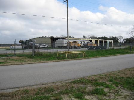
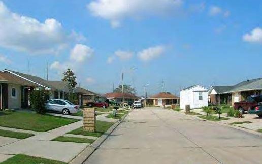 Agriculture Street LandfillThe 95-acre Agriculture Street Landfill Superfund site is located in New Orleans, Louisiana. A municipal landfill operated on site from 1909 to 1957. From the 1970s through the late 1980s, parties developed about 47 acres of the site for private and public uses. The area previously supported 67 single-family homes, multi-family dwellings, retail businesses, an elementary school, a community center, a recreation center and an electrical substation. Before 1994, access to the undeveloped portion of the former landfill was unrestricted. This access allowed unauthorized waste disposal and exposure to contaminants. EPA placed the site on the National Priorities List (NPL) in 1994. Between 1997 and 2001, EPA excavated and disposed of nearly 70,000 tons of material. EPA replaced this material with a permeable layer below ground, clean fill and sod. Hurricanes Katrina and Rita destroyed many structures on site. After these hurricanes, only single-family homes, several in-home businesses and the electrical substation remained. All other structures on site await demolition or redevelopment. The rest of the site remains undeveloped and vegetated. In 2014, the Superfund Redevelopment Initiative provided support to develop a reuse zones concept map and redevelopment site profile to promote redevelopment. In 2018, the U.S. Army Corps of Engineers completed the temporary relocation of a rail line adjacent to the undeveloped area. This is part of an infrastructure improvement project along the Florida Canal.
Last updated September 2019
As of December 2019, EPA had data on 5 on-site businesses. These businesses employed 6 people and generated an estimated $266,000 in annual sales revenue. For additional information click here.
For more information:
American Creosote Works, Inc. (Winnfield Plant)
 American Creosote Works, Inc. (Winnfield Plant)The 34-acre American Creosote Works, Inc. Superfund site is located in Winnfield, Louisiana. From 1901 to 1979, companies treated wood on site. In 1981, Stallworth Timber Company bought the site and continued wood treatment. Site operations contaminated soil and storage areas. Site inspections by the Louisiana Department of Environmental Quality between 1982 and 1986 found chemical spills, abandoned pits and containers, and off-site contamination. EPA added the site to the National Priorities List (NPL) in 1992. Initial cleanup included destruction of liquid contaminants, soil caps, soil treatment and monitoring of groundwater. A local construction firm currently uses part of the site for storage of heavy equipment. The city of Winnfield and Winn Parish are using the southern portion of the site for joint fire training exercises. Future enhancements to the fire training facility are planned.
Last updated September 2019
As of December 2019, EPA did not have economic data related to on-site businesses, or economic data were not applicable due to site use. For additional information click here.
For more information:
- Finding a Market for Recovered Creosote: Green Remediation at the American Creosote Works, Inc. (Winnfield Plant) Superfund Site in Northern Louisiana (PDF) (10 pp, 934 K, About PDF)
- Superfund Site Profile Page
Bayou Bonfouca 
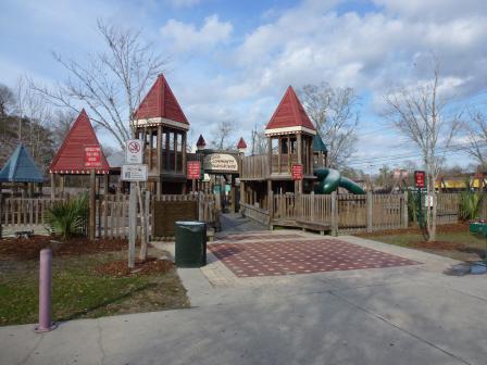 Bayou BonfoucaThe 54-acre Bayou Bonfouca Superfund site is located in Slidell, Louisiana. A commercial wood treating plant operated on site for more than 100 years. A fire destroyed the plant in the early 1970s and released large volumes of creosote directly into the bayou. Years of unregulated waste disposal practices released contaminants into the soil, bayou and surrounding area. EPA added the site to the National Priorities List (NPL) in 1983. Cleanup included removing and consolidating on-site contaminated soils, dredging Bayou Bonfouca’s contaminated sediments, incinerating contaminated soils and sediments on site, and removing and treating contaminated groundwater. Operations and maintenance activities are ongoing. The Louisiana Department of Environmental Quality (LDEQ) operates and maintains the site’s groundwater pump-and-treat system. LDEQ also performs routine groundwater monitoring. Today, the city of Slidell (the City) uses part of the site for public operations offices and other city services. Other parts of the site, including the bayou, are devoted to aquatic life conservation and recreational and public uses. During cleanup, EPA installed a boat ramp to access the bayou. Later, site owners donated this prime waterfront property to the City. The boat ramp is now available for public use and provides boat access to Bayou Bonfouca. The City also coordinated with EPA and LDEQ to develop community green space and a city park, known as Heritage Park. The park includes playgrounds, picnic areas, walking/jogging paths, restrooms and a gazebo for performances and community gatherings. In 2012, the City received a $1.5 million grant to promote boating access along Bayou Bonfouca near the site. Coordination among the City, LDEQ and EPA paved the way for the Slidell Municipal Marina. The project includes floating docks, piers, trails and other amenities to encourage recreational boating on Bayou Bonfouca. The new marina provides boaters with access to Heritage Park and downtown Slidell from Lake Pontchartrain. Slidell Municipal Marina opened in the summer of 2018. In May 2018, EPA Region 6 recognized the community’s efforts to support beneficial site reuse with an Excellence in Site Reuse Award.
Last updated September 2019
As of December 2019, EPA had data on 5 on-site businesses. These businesses employed 130 people and generated an estimated $7,454,993 in annual sales revenue. For additional information click here.
For more information:
- Bayou Bonfouca Superfund Site - Before and After
- Redevelopment of the Bayou Bonfouca Superfund Site (PDF)(3 pp, 2.8 MB)
- Superfund Site Profile Page
Bayou Verdine 
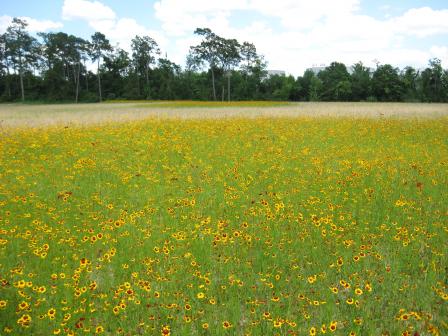 Bayou VerdineThe Bayou Verdine site is located in the Calcasieu Estuary in Lake Charles, Louisiana. Surrounding areas support commercial and heavy industrial uses, with some natural riparian areas. Over time, contaminants from heavy industry, refinery operations and stormwater runoff accumulated in sediments and surface water of Bayou Verdine. In 1999, EPA began studying the Calcasieu Estuary and found high levels of metals and hazardous chemicals. In 2011, EPA and the responsible parties, Phillips 66 and Sasol North America, entered an agreement for the cleanup of a two-mile stretch of Bayou Verdine. The parties removed contaminated sediments and put them in a containment cell on the refinery property. They then capped the containment cell. Phillips 66 also reinforced parts of the bayou shoreline, which runs through the Phillips 66 refinery property, to prevent future erosion. To improve the ecological function of the area, EPA and the parties worked together on ecological enhancements. After sediment removal, a pond west of the containment cell remained as wildlife habitat. The parties connected the pond to Bayou Verdine through a drainage bioswale designed to reduce erosion and provide additional habitat for wildlife and fish. The parties also seeded the containment cell cap with native wildflowers to create pollinator habitat. In October 2015, EPA Region 6 presented the Greenovations Award to Phillips 66, Sasol and other stakeholders for their work on the site.
Last updated September 2019
As of December 2019, EPA did not have economic data related to on-site businesses, or economic data were not applicable due to site use. For additional information click here.
For more information:
- Recreational and Ecological Use at Superfund Sites Story MapEXIT
- Ecological Revitalization on the Bayou: Bayou Verdine in Calcasieu Parish, Louisiana (PDF)(10 pp, 6.7 MB)
- Video: Restoring the Bayou Verdine: Improving Our Communities Exit
- Superfund Site Profile Page
Central Wood Preserving Co.
The 17-acre Central Wood Preserving Co. Superfund site is located in East Feliciana Parish, Louisiana. From the 1950s to 1973, the Central Creosoting Company operated a wood-treating facility at the site. Wood-treating products contaminated site soils, sediments and groundwater. In 1991, the company filed for bankruptcy and closed the facility. Initial cleanup actions included removing tanks and contaminated soils near the main facility and installing a fence around the site. EPA placed the site on the National Priorities List (NPL) in 1999. Additional cleanup work includes treating contaminated soils, filling excavated areas with clean soil, replanting these areas and monitoring groundwater. EPA worked with the community to include future use considerations in site cleanup and restoration plans. The East Feliciana Parish reuse plan allowed for site grading and planting of Loblolly Pine seedlings, Cherrybark Oak trees and grasses. The Parish uses the site as a staging area for brush and wood debris collected after hurricane/storm-related events and residential tree maintenance.
Last updated September 2019
As of December 2019, EPA did not have economic data related to on-site businesses, or economic data were not applicable due to site use. For additional information click here.
For more information:
Delatte Metals
The 57-acre Delatte Metals Superfund site is located in Tangipahoa Parish, near Ponchatoula, Louisiana. In the 1960s, two battery recycling and smelting operations were active on site. Facility operations and waste disposal practices resulted in soil, sediment, surface water and groundwater contamination. EPA placed the site on the National Priorities List (NPL) in 1999. Cleanup activities included excavation, solidification and disposal of contaminated soil, installation of a permeable reactive barrier to neutralize the acidity of groundwater, and decontamination and disposal of on-site buildings and concrete slabs. Cleanup also included site fencing, institutional controls, and groundwater monitoring. Following cleanup, EPA took the site off the NPL in 2005. A residence and a machine shop are currently located on site.
Last updated September 2019
As of December 2019, EPA had data on one on-site business. This business employed 3 people and generated an estimated $41,000 in annual sales revenue. For additional information click here.
For more information:
Gulf Coast Vacuum Services
 Gulf Coast Vacuum ServicesThe 12.8-acre Gulf Coast Vacuum Services Superfund site is located near Abbeville, Louisiana. Starting in 1969, Gulf Coast Vacuum Services (GCVS) operated a vacuum truck facility and stored oil drilling mud on site. These operations involved dumping waste materials and disposing of used rinse water in on-site pits. The waste disposal practices contaminated soil and groundwater. A citizen complaint led to the discovery of the site in 1980. EPA added the site to the National Priorities List (NPL) in 1989. Cleanup activities included soil stabilization and capping. About 8 acres of the site are now cleaned up and available for unrestricted use. In September 1999, site owners and the Vermilion Parish Police Jury (VPPJ) entered into a site use and access agreement. VPPJ currently uses part of the site for vehicle maintenance activities. As part of the agreement, VPPJ maintains the access roads and gates. EPA took the site off the NPL in 2001.
Last updated September 2019
As of December 2019, EPA had data on one on-site business. This business employed 10 people. For additional information click here.
For more information:
Gulf State Utilities-North Ryan Street
 Gulf State Utilities - North Ryan StreetThe 20-acre Gulf State Utilities North Ryan Street Superfund site is located on the Calcasieu River in Lake Charles, Louisiana. Beginning in 1916, various companies manufactured gas at the site. Site operators discharged coal tar byproducts into wetlands surrounding the site. Operators also repurposed a 6-acre wetlands area as a landfill and disposed of contaminated electrical equipment, drums, transformer oil and other wastes there. With the availability of natural gas later in the century, coal gas production activities ended at the site in 1932. In 1988, utility workers digging a trench found oily material seeping from the ground. Investigations found that site activities had contaminated soil, sediment and groundwater with hazardous chemicals. EPA proposed the site for listing on the National Priorities List (NPL) in 1995. Cleanup included removing contaminated soil and sediment, dewatering, and on-site consolidation and capping of contamination. After completing river dredging, the potentially responsible party (PRP) covered part of the southern bank of the Calcasieu River with a mat of concrete blocks to help stabilize the shoreline and protect the restored area. The remedy also included land and groundwater use restrictions. Long-term groundwater monitoring is ongoing. The site’s remedy allows for continued use of the site for industrial and commercial purposes. The site is home to the Lake Charles Division Service Center of Entergy Gulf States Louisiana, LLC, an electrical power production and retail distribution company.
Last updated September 2019
As of December 2019, EPA had data on one on-site business. This business employed 150 people and generated an estimated $1,180,000 in annual sales revenue. For additional information click here.
For more information:
Highway 71/72 Refinery
 Highway 71/72 RefineryThe 215-acre Highway 71/72 Refinery site is located in Bossier City, Louisiana. Between 1923 and 1929, the Louisiana Oil Refining Corporation built a refinery on site to produce home heating and fuel oil. The former refinery property changed hands several times during refinery operations. By the mid-1950s, property owners had dismantled, removed and sold most of the refinery equipment. In 1964, the Louisiana Department of Highways acquired two tracts of the site property and constructed a right-of-way for Interstate 20. In November 1966, property owner Cities Service Company (CSC) announced plans for demolition of remaining refinery structures and cleanup of the property. CSC, and later OXY USA, Inc. (OXY), began further environmental investigations in 1985. They found that cleanup activities conducted in the mid-1960s had not adequately addressed contamination at the former refinery. EPA proposed placing the former refinery property on EPA’s National Priorities List (NPL) in February 1995. EPA did not finalize the site on the NPL. The site’s potentially responsible party (PRP) addressed the cleanup using the Superfund Alternative Approach. This requires the same investigations, cleanup process and standards required for sites listed on the NPL. EPA required two removal actions to address immediate threats caused by surface soil contamination and indoor air contamination. OXY and Glenn Springs Holdings, Inc. (GSHI) performed the actions on behalf of PRP CanadianOxy Offshore Production Co. (COOPCO). EPA selected a final cleanup remedy in September 2000 to address remaining contamination. EPA, the state and the PRP worked together on a cleanup that would allow safe site development and be compatible with ongoing land uses at the site. Cleanup activities include groundwater remediation; soil sampling for specific contaminants of concern; cleanup of contaminated soil discovered during sampling or uncovered during earthmoving activities; a groundwater monitoring program; and indoor air sampling and mitigation of indoor air contamination. Large-scale demolition and excavation were not feasible cleanup options in the heavily developed area. The remedy also required groundwater use restrictions, monitoring and periodic notifications for people living and working on site of the contamination and cleanup, available services and groundwater use restrictions. GSHI completed construction of the groundwater treatment system in 2010. An ordinance, adopted by Bossier City in 2000, prohibits the installation of groundwater wells and prohibits use of groundwater from existing wells within site boundaries. All residents obtain drinking water from the city’s public water supply. The selected remedy protects human health and the environment while allowing businesses and residences to remain in place. It also made new development possible. Today, site uses include single-family homes, apartment buildings, commercial buildings, restaurants, public parks, churches and light industrial businesses. An operating pipeline and highway cross the site. About 3,500 people live in the former refinery area.
Last updated September 2019
As of December 2019, EPA had data on 48 on-site businesses. These businesses employed 471 people and generated an estimated $48,800,000 in annual sales revenue. For additional information click here.
For more information:
- Reuse and the Benefit to the Community: Highway 71/72 Refinery Site (PDF)(14 pp, 2.3 MB, About PDF)
- Superfund Site Profile Page
Madisonville Creosote Works
The 29-acre Madisonville Creosote Works Superfund site is located in St. Tammany Parish, about 1.5 miles from Madisonville, Louisiana. A creosote wood-treating facility began operations on site around 1956. Facility operations contaminated soil and groundwater with hazardous chemicals. EPA added the site to the National Priorities List (NPL) in 1986. The site’s long-term remedy included low-temperature thermal desorption, a dense non-aqueous phase liquid (DNAPL) recovery trench system, institutional controls to prevent human exposure to contaminants, and groundwater monitoring. Cleanup activities finished in 2000. Following construction of the site’s remedy, operation and maintenance activities are ongoing. A state air monitoring station is located on site.
Last updated September 2019
As of December 2019, EPA did not have economic data related to on-site businesses, or economic data were not applicable due to site use. For additional information click here.
For more information:
Mallard Bay Landing Bulk Plant
The 10-acre Mallard Bay Landing Bulk Plant (MBLP) Superfund site is located in Cameron Parish, northeast of Grand Chenier, Louisiana. The site consists of two 5-acre areas separated by Talen’s Marine, a marina and dock. From early 1980 through 1983, the MBLP facility operated as a crude oil refinery. In 1987, the owners filed for bankruptcy and the facility closed. An inspection in 1993 revealed oily liquids and sludges in tanks and other environmental concerns. Initial cleanup activities included the removal and off-site disposal of oil and waste material from on-site tanks. EPA placed the site on the National Priorities List (NPL) in 2000 to address remaining contamination. In 2003 and 2004, EPA removed all remaining tank sludges, contaminated soil and structures. After cleanup, EPA took the site off the NPL in 2005. Talen’s Marine is currently using the site as a staging and storage area.
Last updated June 2017
As of December 2019, EPA had data on one on-site business. EPA did not have further economic details related to this business. For additional information click here.
For more information: